E1082 V. 2
Public Disclosure Authorized
Public Disclosure Authorized
Public Disclosure Authorized
Public Disclosure Authorized
PROJECT NO. NSD18976
FINAL REPORT TO
THE UNITED REPUBLIC OF TANZANIA
ON
ENVIRONMENTAL AND SOCIAL ASSESSMENT
OF THE
MARINE AND COASTAL MANAGEMENT PROJECT (MACEMP)
Prepared by:
Jacques Whitford Environment Limited
3 Spectacle Lake Drive
Dartmouth, NS B3B 1W8
CANADA
Tel: +1 902 468 7777
Fax: +1 902 468 9009
24 January 2005
TABLE OF CONTENTS
Page No.
1.0
INTRODUCTION.................................................................................................................................. 1
1.1
Project Purpose.......................................................................................................................... 1
1.2
Operational Policy Context ....................................................................................................... 1
2.0
ADMINISTRATIVE FRAMEWORK, POLICIES AND LEGISLATION........................................... 3
2.1
MACEMP Administrative Framework ..................................................................................... 3
2.1.1 Responsible Agency..................................................................................................... 3
2.1.2 Management and Implementation Structure ................................................................ 3
2.2
Relevant Policies and Legislation ............................................................................................. 3
2.2.1 Policies and Legislation for Mainland Tanzania .......................................................... 4
2.2.2 Policies and Legislation for Zanzibar........................................................................... 6
2.2.3 Policies and Legislation Applicable to both Mainland Tanzania and Zanzibar ........... 7
2.2.4 International Agreements ............................................................................................. 7
3.0
PROJECT DESCRIPTION .................................................................................................................... 9
3.1
Component 1: Sound Management of the EEZ......................................................................... 9
3.2
Component 2: Sound Management of the Coastal and Marine Environment ......................... 10
3.3
Component 3: Coastal Community Action Fund .................................................................... 13
3.4
Project Alternatives ................................................................................................................. 13
4.0
PROJECT AREA ................................................................................................................................. 15
4.1
Marine and Coastal Ecosystems.............................................................................................. 15
4.1.1 Physical Oceanography and Climate.......................................................................... 15
4.1.2 Marine and Coastal Habitats ...................................................................................... 17
4.1.3 Important Species ....................................................................................................... 18
4.1.4 Current Status of Marine Protected Areas and Marine Management Areas .............. 19
4.2
Communities ........................................................................................................................... 19
4.2.1 Population................................................................................................................... 19
4.2.2 Households ................................................................................................................. 20
4.2.3 Social Characteristics of Initial Target Geographic Areas ......................................... 21
5.0
IMPACT ASSESSMENT METHODOLOGY .................................................................................... 22
5.1
Selection of Valued Aspects.................................................................................................... 22
5.2
Potential Impacts of the Project on Valued Aspects................................................................ 24
5.3
Impact Evaluation.................................................................................................................... 24
5.4
Determination of Mitigation, Monitoring and Evaluation....................................................... 31
5.5
Information Collection ............................................................................................................ 31
6.0
ENVIRONMENTAL AND SOCIAL IMPACT ASSESSMENT........................................................ 33
6.1
Valued Environmental Aspects ............................................................................................... 33
6.1.1 Marine Ecosystems .................................................................................................... 33
6.1.1.1 Existing Conditions ................................................................................................................. 33
6.1.1.2 Effects Assessment.................................................................................................................. 34
6.1.2 Coastal Ecosystems .................................................................................................... 35
6.1.2.1 Existing Conditions ................................................................................................................. 35
MACEMP
ESA
Ę Final Report Ę 24 January 2005
Page i
6.1.2.2 Effects Assessment.................................................................................................................. 37
6.2
Valued Socio-cultural Components......................................................................................... 38
6.2.1 Social Capital ............................................................................................................. 38
6.2.1.1 Existing Conditions ................................................................................................................. 39
6.2.1.2 Effects Assessment.................................................................................................................. 40
6.2.2 Vulnerable Groups ..................................................................................................... 41
6.2.2.1 Existing Conditions ................................................................................................................. 41
6.2.2.2 Effects Assessment.................................................................................................................. 42
6.2.3 Cultural Property and Antiquities............................................................................... 42
6.2.3.1 Existing Conditions ................................................................................................................. 43
6.2.3.2 Effects Assessment.................................................................................................................. 43
6.3
Valued Economic Components ............................................................................................... 44
6.3.1 Commercial and Artisanal Fisheries .......................................................................... 44
6.3.1.1 Existing Conditions ................................................................................................................. 44
6.3.1.2 Effects Assessment.................................................................................................................. 46
6.3.2 Tourism ...................................................................................................................... 47
6.3.2.1 Existing Conditions ................................................................................................................. 47
6.3.2.2 Effects Assessment.................................................................................................................. 48
6.3.3 Coastal Forest Resource Use...................................................................................... 49
6.3.3.1 Existing Conditions ................................................................................................................. 49
6.3.3.2 Effects Assessment.................................................................................................................. 50
6.3.4 Mariculture ................................................................................................................. 51
6.3.4.1 Existing Conditions ................................................................................................................. 51
6.3.4.2 Effects Assessment.................................................................................................................. 51
6.3.5 Other Livelihood Activities........................................................................................ 52
6.3.5.1 Existing Conditions ................................................................................................................. 53
6.3.5.2 Effects Assessment.................................................................................................................. 53
6.4
Valued Institutional Components............................................................................................ 54
6.4.1 National and Local Government ................................................................................ 54
6.4.1.1 Existing Conditions ................................................................................................................. 55
6.4.1.2 Effects Assessment.................................................................................................................. 58
6.4.2 NGOs, CBOs and the Private Sector.......................................................................... 59
6.4.2.1 Existing Conditions ................................................................................................................. 60
6.4.2.2 Effects Assessment.................................................................................................................. 63
6.5
Cumulative Effects .................................................................................................................. 64
6.5.1 TASAF II.................................................................................................................... 64
6.5.2 JSDF Activities .......................................................................................................... 66
6.5.3 Local Government Support Programme (LGSP) ....................................................... 67
6.5.4 PADEP ....................................................................................................................... 67
6.5.5 European Union Programmes .................................................................................... 68
6.5.6 Restoration of Cultural Heritage Sites........................................................................ 68
6.5.7 The South West Indian Ocean Fisheries Project ........................................................ 69
6.5.8 The Targeted Research Project on Coral Reef Management ..................................... 69
6.5.9 The Tanzania Coastal Management Partnership ........................................................ 70
6.5.10 The National Strategy for Growth and Poverty Reduction ........................................ 70
6.5.11 Summary of Cumulative Effects Assessment ............................................................ 71
7.0
EXISTING MITIGATIVE POLICIES AND LEGISLATION............................................................ 73
7.1
Environmental Management ................................................................................................... 73
7.1.1 Mainland Tanzania..................................................................................................... 73
7.1.2 Zanzibar...................................................................................................................... 74
7.2
Coastal Zone and Marine Management................................................................................... 75
7.2.1 Mainland Tanzania..................................................................................................... 75
MACEMP
ESA
Ę Final Report Ę 24 January 2005
Page ii
7.2.2 Zanzibar...................................................................................................................... 75
7.2.3 The Union................................................................................................................... 76
7.3
Fisheries Management............................................................................................................. 76
7.3.1 Mainland Tanzania..................................................................................................... 76
7.3.2 Zanzibar...................................................................................................................... 78
7.4
Coastal Forest Management .................................................................................................... 79
7.4.1 Mainland Tanzania..................................................................................................... 79
7.4.2 Zanzibar...................................................................................................................... 79
7.5
Land Management................................................................................................................... 80
7.5.1 Mainland Tanzania..................................................................................................... 80
7.5.2 Zanzibar...................................................................................................................... 81
7.6
Cultural Property and Antiquities............................................................................................ 81
8.0
RECOMMENDATIONS FOR ENVIRONMENTAL MANAGEMENT ........................................... 83
8.1
Recommendations for Mitigation............................................................................................ 83
8.2
Environmental Assessment Process and Procedures for Sub-projects .................................... 85
8.2.1 Categorisation of Sub-projects for Environmental Assessment ................................. 85
8.2.2 The Environmental Assessment Process .................................................................... 86
8.2.3 Public Consultation and Disclosure ........................................................................... 87
8.2.4 Environmental Management Plans for Sub-projects.................................................. 87
8.3
Recommendations for Project Monitoring and Evaluation ..................................................... 87
8.3.1 Impact indicators ........................................................................................................ 87
8.3.2 Monitoring and Evaluation Procedures ...................................................................... 88
9.0
CONSULTATIONS............................................................................................................................. 91
9.1
Consultation Programme......................................................................................................... 91
9.2
Stakeholder Comments and Concerns..................................................................................... 92
10.0
BIBLIOGRAPHY ................................................................................................................................ 95
MACEMP
ESA
Ę Final Report Ę 24 January 2005
Page iii
LIST OF TABLES
Page No.
Table 2.1
Coastal and Marine Resource Management Policies and Legislation for Mainland Tanzania ..5
Table 2.2
Coastal and Marine Resource Management Policies and Legislation for Zanzibar...................6
Table 2.3
Coastal and Marine Resource Management Policies and Legislation Applicable to both
Mainland Tanzania and Zanzibar ...............................................................................................7
Table 2.4
International Agreements Relevant to Coastal and Marine Resource Management in
the URT ......................................................................................................................................7
Table 3.1
Sub-components and Activity Descriptions for Sound Management of the EEZ ......................9
Table 3.2
Sub-components and Activity Descriptions for Sound Management of the Coastal and
Marine Environment.................................................................................................................11
Table 3.3
Sub-components and Activity Descriptions for the Coastal Community Action Fund............13
Table 4.1
Marine Management Areas in the URT (including MPAs and Local ICM Programmes) .......19
Table 4.2
Population density for coastal regions of the URT...................................................................20
Table 4.3
Household Access to Social Services.......................................................................................21
Table 5.1
Identified Valued Aspects ........................................................................................................23
Table 5.2
Summary of Potential Impacts of Component 1 (Sound Management of the EEZ)
on Valued Aspects....................................................................................................................25
Table 5.3
Summary of Potential Impacts of Component 2 (Sound Management of the Coastal and
Marine Environment) on Valued Aspects ................................................................................27
Table 5.4
Summary of Potential Impacts of Component 3 (Coastal Community Action Fund)
on Valued Aspects....................................................................................................................29
Table 6.1
Assessment of Impacts on Marine Ecosystems........................................................................34
Table 6.2
Assessment of Impacts on Coastal Ecosystems .......................................................................38
Table 6.3
Assessment of Impacts on the Social Capital...........................................................................40
Table 6.4
Economic Activities for Male and Female Headed Households..............................................41
Table 6.5
Assessment of Impacts on Vulnerable Groups.........................................................................42
Table 6.6
Assessment of Impacts on Cultural Property and Antiquities..................................................43
Table 6.7
Assessment of Impacts on Fisheries.........................................................................................46
Table 6.8
Visitors to Tanzania Marine Reserves......................................................................................47
Table 6.9
Assessment of Impacts on Tourism..........................................................................................48
Table 6.10
Assessment of Impacts on Coastal Forest Resource Use .........................................................50
Table 6.11
Assessment of Impacts on Mariculture ....................................................................................52
Table 6.12
Assessment of Impacts on Other Livelihood Activities ...........................................................54
Table 6.13
District-level Authorities Within Coastal Mainland Tanzania .................................................56
Table 6.14
Regions and Districts within Zanzibar .....................................................................................58
Table 6.15
Assessment of Impacts on National and Local Government....................................................59
Table 6.16
NGOs Active in the URT .........................................................................................................61
Table 6.17
Assessment of Impacts on NGOs, CBOs and the Private Sector .............................................63
Table 6.18
Assessment of Cumulative Effects Associated with Development Programmes.....................71
MACEMP
ESA
Ę Final Report Ę 24 January 2005
Page iv
Table 8.1
Summary of Recommended Mitigation for MACEMP by Project Component.......................84
Table 8.2
Impact Indicator Recommendations for Monitoring and Evaluation.......................................89
Table 9.1
Record of Scoping Workshop, Focus Groups and Stakeholder Interviews..............................91
Table 9.2
Summary of Stakeholder Comments and Concerns .................................................................93
LIST OF FIGURES
Page No.
Figure 2.1
MACEMP Management and Implementation Structure ............................................................4
Figure 4.1
Geographical Areas of Focus for Initial MACEMP Sub-projects............................................16
Figure 6.1
Relationships between National and Local Government in Mainland Tanzania .....................55
Figure 6.2
Relationships between National and Local Government in Zanzibar ......................................57
LIST OF APPENDICES
Appendix A
Triggered World Bank Safeguard Policies
Appendix B
MACEMP Administrative Framework
Appendix C
Existing Biophysical Environment
Appendix D
Social Characteristics of Initial Target Geographic Areas
Appendix E
Stakeholder Interview Materials
Appendix F
Environmental Screening Process Forms
Appendix G
Types of Projects that Require EIA in Mainland Tanzania
Appendix H
Activities which do not Require an EIA Certificate and Activities which do require an EIS in
Zanzibar
Appendix I
World Bank Categorisation of Projects for EA
Appendix J
Environmental Management Plan Matrix for Sub-projects
Appendix K
Stakeholder Consultations
MACEMP
ESA
Ę Final Report Ę 24 January 2005
Page v
LIST OF ACRONYMS
AED
Academy for Educational Development
AIGA
Alternative Income Generating Activity
BMU
Beach Management Unit
CARE
CARE Tanzania
CBFM
Community-based Forest Management
CBO
Community-based Organization
CEAS
Coastal Environmental Award Scheme
CHICOP
Chumbe Island Coral Park Ltd.
CI Chumbe
Island
CITES
Convention on International Trade on Endangered Species
CMA
Community Management Area
CMAP
Community Mitigation Action Plan
CPUE
Catch Per Unit Effort
DCCFF
Department of Commercial Crops, Fruits and Forestry [Zanzibar]
DFMP
Department of Fisheries and Marine Products
DOE
Department of Environment
DoE-VPO
Division of Environment-Vice President's Office
EA
Environmental
Assessment
EACC
East African Coastal Current
EAP
Environmental Action Plan
EEZ
Exclusive Economic Zone
EIA
Environmental Impact Assessment
EIS
Environmental Impact Statement
EMP
Environmental Management Plan
EM
Environmental
Monitoring
ESA
Environmental and Social Assessment
ESMF
Environmental and Social Management Framework
EU
European Union
GEF
Global Environment Facility
GOOS
Global Ocean Observing System
IBAs
Important Bird Areas
ICM
Integrated Coastal Management
IMS
Institute of Marine Sciences - Zanzibar
IUCN
International Union for the Conservation of Nature/ The World Conservation Union
IUCN EARO Eastern African Regional Office of the International Union for the Conservation of Nature
JEBA
Jumuiya Endelevu Bagamoyo (JEBA Society)
JOCDO
Jozani Credit Development Organization
JSDF
Japanese Social Development Fund
LGA
Local Government Authority
LGRP
Local Government Reform Programme
LGSP
Local Government Support Programme
MACEMP
Marine and Coastal Environment Management Project
MACT
Marine Action Conservation Tanzania
MANREC
Ministry of Agriculture, Natural Resources, Environment and Co-operatives
MCS
Monitoring, Control and Surveillance
MLF
Marine Legacy Fund
MMA
Marine Management Area
MMP
Mangrove Management Project
MNCY
Ministry of National Culture and Youth
MACEMP
ESA
Ę Final Report Ę 24 January 2005
Page vi
MNRT
Ministry of Natural Resources and Tourism
MPA
Marine Protected Area
MR
Marine Reserve
MSME
Micro, Small and Medium Enterprises
NEMC
National Environment Management Council
NGO
Non-government Organization
NSGRP
National Strategy for Growth and Reduction of Poverty
PADEP
Participatory Agricultural Development and Empowerment Project
PCU
Project Coordination Unit
PF
Process
Framework
PIM
Project Implementation Manual
PMU
Project Management Unit
PORALG
President's Office for Regional Administration and Local Government
PRA
Participatory Rural Appraisal
RAMSAR
Convention on Wetlands of International Importance
REMP
Rufiji Environment Management Project
RIPS
Rural Integrated Project Support
SACCO
Savings and Credit Cooperative Societies
SAMP
Special Areas Management Plan
SHIRIKISHO Shirikisho la kuhifadhi Mazingira ya Bahari Kanda ya Kusini (The Southern Zone
Confederation for the Conservation of the Marine Environment)
SWIOFP
South West Indian Ocean Fisheries Project
TAFIRI
Tanzania Fisheries Research Institute
TASAF
Tanzania Social Action Fund
TAWLAE
Tanzania Association of Women Leaders in Agriculture and the Environment
TCMP
Tanzania Coastal Management Partnership
TCZCDP
Tanga Coastal Zone Conservation and Development Programme
UNESCO
United Nations Education, Science and Culture Organization
URT
United Republic of Tanzania
USA
United States of America
USAID
United States Agency for International Development
VPO
Vice President's Office
WB
World
Bank
WIO
Western Indian Ocean
WIOMSA
Western Indian Ocean Marine Science Association
WWF
World Wildlife Fund
ZRG
Zanzibar Revolutionary Government
MACEMP
ESA
Ę Final Report Ę 24 January 2005
Page vii
ACKNOWLEDGEMENTS
This report was prepared by Dr. Kent Gustavson (Project Manager), Dr. Jay Walmsley (Senior Scientist) and
Ms. Zoļ Kroeker (Analyst) of Jacques Whitford Environment Limited. Dr. Dan Walmsley, of Walmsley
Environmental Consultants, served as an advisor on the project. The authors would like to acknowledge the
invaluable assistance provided by Ms. Saada Juma, of Agenda, who prepared the background Situation
Analysis report and other information that served as input to the ESA. The project co-ordinators for the United
Republic of Tanzania were Mr. Baraka Mngulwi (Ministry of Natural Resources and Tourism, Tanzania), Mr.
Magese Bulayi (Ministry of Natural Resources and Tourism, Tanzania), Mr. Sheha Hamdan (Ministry of
Agriculture, Natural Resources, Environment and Co-operatives, Zanzibar), and Mr. AM Othman (Ministry of
Agriculture, Natural Resources, Environment and Co-operatives, Zanzibar). The authors would also like to
acknowledge the co-operation and assistance provided by the many personnel within the Government of
Tanzania and the Revolutionary Government of Zanzibar. Dr. Jack Ruitenbeek (H.J. Ruitenbeek Resource
Consulting Limited), Ms. Indu Hewawasam (World Bank, Tanzania Office), and Dr. Roxanne Hakim (Social
Development Department, World Bank) provided important guidance as part of the World Bank Task Team.
MACEMP
ESA
Ę Final Report Ę 24 January 2005
Page viii
DEFINITIONS
Environmental
The process of managing the environmental aspects of a policy, strategy, programme
Assessment:
or sub-project from the earliest stages of identifying the potential activities to their
completion and evaluation. The process encompasses identification of potential
adverse impacts, assessment of those impacts, design and implementation of measures
to avoid, minimise, mitigate or compensate for adverse impacts, and development of
appropriate management and monitoring measures.
Environmental
An environmental assessment instrument to identify and assess major potential
Impact Assessment: environmental impacts of proposed sub-projects, evaluate alternatives and design
appropriate mitigation, management and monitoring measures.
Environmental
An instrument that details the measures to be taken during the implementation of a
Management Plan: project to eliminate or offset adverse environmental impacts, or to reduce them to
acceptable levels; and the actions needed to implement these measures.
Environmental
Monitoring is the systematic measuring and recording of physical, social and
Monitoring:
economic variables associated with project impacts. The objective of monitoring is to
provide information on the characteristics and functioning of the occurrence and
magnitude of impacts, and whether mitigation measures have been carried out.
Environmental
An environmental assessment instrument in which the sub-projects are likely to have
Review:
minimal impacts, but are to be reviewed using a standardised checklist to identify
possible impacts and appropriate mitigation measures.
Environmental
A process of identifying the potential adverse environmental and social impacts of
Screening:
proposed sub-projects and, based on the level of impact anticipated, the corresponding
level of environmental assessment required (i.e., the most appropriate environmental
assessment instrument needed to address potential impacts and environmental issues
associated with sub-projects). The screening process indicates whether an
environmental assessment is required for a particular sub-project and, if it is required,
which of the three environmental instruments (Environmental Review, Limited
Environmental Assessment, or Environmental Impact Assessment) should be applied.
Limited
An environmental assessment instrument used to assess whether a sub-project is likely
Environmental
to cause environmental impacts that merit consideration by an environmental
Assessment:
specialist, and which mitigation measures should be incorporated into the sub-project
design. Detailed checklists, customised for different types of sub-projects, would
normally be used and supplemented on a case-by-case basis.
Marine Protected
Marine Protected Areas (MPAs) are areas of the marine environment that are reserved
Area:
under national, tribal, or local laws or regulations to provide long-term protection for
part or all of the natural and cultural resources therein. In relation to the Process
Framework, the reference to MPAs includes Marine Management Areas (MMA) and
Community Management Areas (CMAs).
Process
The Process Framework is an instrument of the United Republic of Tanzania prepared
Framework:
in compliance with the World Bank Safeguard Policy on Involuntary Resettlement
(OP4.12). The purpose of the Process Framework is to clarify principles,
organizational arrangements and design criteria to be applied to the implementation of
MPAs, CMAs or MMAs as supported by MACEMP.
Public
The process of engaging affected people and other interested parties in open dialogue
Consultation:
through which a range of views and concerns can be expressed in order to inform
decision-making and help build consensus.
Scoping:
The process for identifying the potential environmental and social impacts of the
project to be evaluated. In the process, consultations with principal stakeholders are
required in order to inform them about the proposed project activities, and to solicit
their views.
MACEMP
ESA
Ę Final Report Ę 24 January 2005
Page ix
Stakeholders:
Stakeholders are those affected by the outcomes (negatively or positively) or those
who can affect the outcome of a proposed intervention. Stakeholders can include:
borrowers; directly affected groups including the poor and disadvantaged; indirectly
affected groups such as NGOs and private sector organizations; and the World Bank
management staff, and shareholders.
Sub-Projects:
Sub-projects are initiatives undertaken as supported by the Coastal Village Fund
(Component 3) of MACEMP, or as supported by TASAF. Sub-projects are aimed at
supporting income generation within coastal communities. Initiatives may include the
demand of technical, physical or social services, including alternative income
generating activities (AIGAs).
United Republic of The United Republic of Tanzania consists of Tanzania (the Mainland and several
Tanzania (URT):
near-shore islands, including Mafia Island) and Zanzibar (the islands of Unguja and
Pemba).
MACEMP
ESA
Ę Final Report Ę 24 January 2005
Page x
EXECUTIVE SUMMARY
This document presents the Environmental and Social Assessment (ESA) for the Marine and Coastal
Environment Management Project (MACEMP) (the Project) of the United Republic of Tanzania (URT).
MACEMP is a 6-year project anticipated to begin mid 2005. The purpose of the Project is to improve
management of coastal and marine resources, to enhance the contribution of these resources to economic
growth, to reduce poverty, and to develop the scientific understanding of the marine and coastal resources and
major threats to them. The Project will:
Ę
Strengthen marine management institutions in Zanzibar and on the Mainland, with a focus on creating a
common governance regime for the Exclusive Economic Zone (EEZ) (Component 1);
Ę
Support coastal area planning and the establishment of a network of marine protected areas (MPAs) and
marine managed areas (MMAs) for conservation of biodiversity and sustainable utilisation of coastal and
marine resources (Component 2); and
Ę
Create an enabling environment for environmentally sustainable investment along the coast
(Component 3).
The principal MACEMP implementing agencies in Tanzania include MNRT (for Mainland Tanzania) and
MANREC (for Zanzibar). Within MNRT, the principal implementing partners will include the Department of
Fisheries and the Department of Antiquities, while within MANREC it will include the Department of
Fisheries, the Department of Environment, and Department of Commercial Crops, Fruits and Forestry.
Over the course of MACEMP, the Project could potentially involve activities focused anywhere within the
coastal zone or the broader EEZ. Individual sub-project opportunities will be identified as the Project
proceeds, based on results achieved in initially selected project target areas. For the first two years of the
Project, the geographical areas of focus for Component 2 (Sound Management of the Coastal and Marine
Environment) and Component 3 (Coastal Community Action Fund) will include the following:
Ę
Rufiji-Kilwa-Mafia Complex
Ę
Trans-boundary MPA with Mozambique (Mnazi Bay-Ruvuma Estuary area)
Ę
Latham Island
Ę
Mnemba Island Marine Conservation Area
Ę
Menai Bay Marine Conservation Area
Ę
Pemba Channel Marine Conservation Area (includes Misali Island Conservation Area)
The potential impacts of MACEMP were evaluated for identified valued environmental aspects (including
marine ecosystems and coastal ecosystems), valued socio-cultural aspects (including social capital, vulnerable
groups, and cultural property and antiquities), valued economic aspects (including commercial and artisanal
fisheries, tourism, coastal forest resource use, mariculture, and other livelihood activities) and valued
institutional aspects (including national and local government, and NGOs, CBOs and the private sector).
Appropriate mitigation measures that will reduce the significance of negative impacts on valued aspects are
identified. For all valued aspects, there are no predicted significant residual negative impacts of the Project
after application of the identified mitigation measures.
The cumulative impact assessment focused on other development programmes specifically affecting the
marine environment, coastal socio-economic conditions or cultural property, and/or use of the marine
environment, and included the following:
Ę
The Tanzania Social Action Fund (TASAF II);
Ę
Japan Social Development Fund (JSDP) activities;
Ę
The Local Government Support Programme (LGRP);
MACEMP
ESA
Ę Final Report Ę 24 January 2005
Page xi
Ę
The Participatory Agricultural Development and Empowerment Project (PADEP);
Ę
European Union Programmes;
Ę
Restoration of Cultural Heritage Sites in Mainland Tanzania and Zanzibar;
Ę
The South West Indian Ocean Fisheries Project;
Ę
The Targeted Research Project on Coral Reef Management;
Ę
The Tanzania Coastal Management Partnership (TCMP); and
Ę
The National Strategy for Growth and Reduction of Poverty
In addition to the development programmes listed above, there are other site-specific coastal zone
management initiatives in coastal areas of the URT. It will be important for MACEMP to effectively link with
these projects where area-based activities overlap. All such donor activities should, in fact, be co-ordinated
through MACEMP, as the larger, coast-wide programme.
Existing URT policies and legislation will serve to mitigate many of the negative impacts of the Project, as
well as enhance the positive impacts in support of the Project's objectives. The relevant policies and
legislation fall under the following categories:
Ę
Environmental management;
Ę
Coastal zone management;
Ę
Fisheries management;
Ę
Coastal forest management;
Ę
Land management; and
Ę
Cultural property and antiquities.
The pertinent feature of the policies and legislation are summarised, with the emphasis on key mitigations for
MACEMP. In addition to the national policies and legislation analysed here, there are several local-level
policies that may apply, but these will vary substantially by region and community. It will be important for
MACEMP to review the applicability of these once individual sites and sub-projects have been identified. Of
particular relevance are Village Land Use Plans and Village By-laws.
The table below summarises the recommended mitigation measures by project component. With respect to
sub-projects implemented under Component 3 (Coastal Community Action Fund), environmental assessment
process and procedures are also described in this report as the appropriate safeguard for evaluating the
potential impacts of individual sub-projects. With respect to MACEMP support for existing and emerging
MPAs under Component 2 (Sound Management of the Coastal and Marine Environment), a Process
Framework is provided as a separate document.
As part of recommendations for environmental management, requirements for monitoring and evaluation are
described to compensate for uncertainties and information gaps in the impact assessment and, more generally,
to ensure that actual residual negative impacts are no greater than as predicted in the assessment.
Recommendations for monitoring and evaluation are in keeping with the principle of adaptive management,
whereby policies, practices or procedures are adjusted appropriately during project implementation to improve
the efficacy of management strategies and mitigation measures.
MACEMP
ESA
Ę Final Report Ę 24 January 2005
Page xii
Summary of Recommended Mitigation for MACEMP by Project Component
Project Component
Recommended Mitigation
Component 1: Sound
Ę MACEMP to develop project phasing strategy with MCS to co-ordinate transfer of activities and/or appropriate division of specific programme activities.
Management of the EEZ
The allocation of social development grants should be done through parallel financing with MACEMP.
Ę MACEMP-related investments in fishing port facilities may trigger national EIA process, depending on project design.
Component 2: Sound
Ę Effective facilitation and assistance at the village level during the preparation of Community Mitigation Action Plans (CMAPs) (see Process
Management of the Coastal and
Framework).
Marine Environment
Ę For MACEMP activities that support management of mangrove ecosystems and rehabilitation of cultural sites, ensure early engagement and involvement
at the village level, ensuring representation and participation of vulnerable groups, as well as resource user groups. Due to existing imbalances in power
and representation that exist within communities, outreach activities will need to ensure the development of effective engagement of all livelihood
activity groups, genders (especially women) and ages (especially youth and elderly). Engagement may be effective through existing village-level rules of
association (e.g., religious leaders, unofficial leaders for specific ethnic groups) (see also recommendations of the Process Framework). An initial village-
level rapid social assessment will be required to acquire necessary information to further inform the development of appropriate engagement processes.
Ę Identification of target cultural heritage sites for rehabilitation to involve the Department of Antiquities (MNRT) in Mainland Tanzania, Department of
Archives, Museums and Antiquities in Zanzibar, and district governments to ensure consistency with national policies and regional priorities.
Subsequent development of investment proposals to involve local government and villages adjacent to sites to ensure consistency with local values and
aspirations.
Ę Incorporate plan information from specific Mangrove Management Plans as part of the site-specific project opportunities identification.
Ę MACEMP to co-ordinate with other smaller donor-funded programmes for the restoration of cultural heritage sites.
Component 3: Coastal
Ę Use of environmental assessment process and procedures for all alternative livelihood sub-projects investments under the Coastal Community Action
Community Action Fund
Fund prior to approval to help ensure activities operate within acceptable environmental parameters specific to the coastal and marine environment.
Ę MACEMP-related investments in mariculture may trigger the national EIA process, depending on project design. Development of guidelines for solar
salt production developments to help ensure appropriate siting and reduction of conflicts with competing coastal resource users. Training and placement
at the regional or district level of mariculturalists, with expertise in siting, design and operation. Development of guidelines for mariculture development
to help ensure appropriate siting and reduction of conflicts with competing coastal resource users (e.g., siting of fish ponds in high saline areas that have
poor mangrove forests).
Ę Training of District Environment Officers in the use of environmental assessment methodologies to facilitate appraisal of MACEMP/TASAF sub-project
proposals. Training would focus on general EIA screening skills, as well as elements of MACEMP sub-projects that would be distinct from those of sub-
projects that would typically be experienced through TASAF.
Ę Early engagement and involvement at the village level, ensuring representation and participation of vulnerable groups, as well as resource user groups.
Due to existing imbalances in power and representation that exist within communities, outreach activities will need to ensure the development of
effective engagement of all livelihood activity groups, genders (especially women) and ages (especially youth and elderly). Engagement may be effective
through existing village-level rules of association (e.g., religious leaders, unofficial leaders for specific ethnic groups) (see also recommendations of the
Process Framework). An initial village-level rapid social assessment will be required to acquire necessary information to further inform the development
of appropriate engagement processes.
Ę During sub-project evaluation, consider TCMP-developed Coastal Activity Guidelines and plan information from specific Mangrove Management Plans,
and ensure consistency of sub-projects with existing Village Land Use Plans.
Ę Complete a rapid assessment of commercial tour operators and develop a spatial database of users (database to be periodically updated). Based on
location and type of activity, relevant operators should be provided the opportunity to annually review a summary of projects funded under the Coastal
Community Action Fund Ł provided for information only. The intent is to allow the commercial tourism sector to identify potential opportunities, as well
as potential conflicts.
Ę Tanzanian commercial fishing operators should also be provided the opportunity to annually review a summary of projects funded under the Coastal
Community Action Fund Ł provided for information only. The intent is to allow the commercial fisheries sector to identify potential opportunities, as
well as potential conflicts.
MACEMP
ESA
Ę Final Report Ę 24 January 2005
Page xiii
1.0
INTRODUCTION
This document presents the Environmental and Social Assessment (ESA) for the Marine and Coastal
Environment Management Project (MACEMP) (the Project) of the United Republic of Tanzania (URT)1.
1.1
Project Purpose
MACEMP is a 6-year project anticipated to begin mid 2005. The purpose of the Project is to improve the
management of coastal and marine resources, with a view to contributing to economic growth and poverty
reduction in coastal communities. The Project emphasizes the establishment of an effective regulatory and
institutional framework, participatory planning and the creation of an enabling environment for integrated
coastal and marine resources management and private investment. Project financing will be secured through
an IDA credit, a GEF grant and Tanzanian government commitments. In addition, bilateral co-financing or
parallel financing will be sought during project preparation.
Beneficiaries will include relevant national and local level agencies responsible for the management of marine
resources, coastal communities of Mainland Tanzania and Zanzibar and the broader society who will benefit
through increased revenues from marine and coastal resources. Key expected outcomes include:
Ę
Increased incomes through improved management of marine resources, increased productivity and added
value from improved post-harvest processing and market access;
Ę
Reduced vulnerability of communities to external shocks through diversification of local production
systems, diminished market risks through mutually beneficial private sector and community partnerships,
and stabilization and reversal of current trends in marine resources degradation and productivity where
possible;
Ę
Increased government revenues from improved management of off-shore fisheries; and
Ę
Improved ecosystem services and conservation of globally significant marine and coastal biodiversity.
1.2
Operational Policy Context
The URT and its funding partner, the World Bank (WB), wish to ensure that the MACEMP is carried out in
line with Tanzania's emerging environmental legislation and the applicable WB Safeguard Policies. A WB
review has determined that the Project is unlikely to cause significant negative impacts on the biophysical and
social environments, and has been classified as a Category B project. Projects are placed in Category B when
their impacts are likely to be site specific, relatively easy to mitigate and reversible within reason. Both the
URT and the WB have determined that an ESA is required.
The ESA and any resulting recommendations with respect to mitigation policies, programmes and procedures
is consistent with the National Environmental Policy (1992) and the Environmental Management for
Sustainable Development Act (1996) of Zanzibar, as well as the National Environmental Policy (1997), the
National Environmental Management Act (1983) and the recently promulgated Environmental Management
Act (2004) of Mainland Tanzania.
For this project, the WB has triggered the following Safeguards (Appendix A):
a) Environmental Assessment (OP 4.01), to be addressed through the ESA.
b) Natural Habitats (OP/BP 4.04), to be addressed through the ESA.
c) Cultural Property (OPN 11.03, being revised as OP 4.11), to be addressed through the ESA.
1 The United Republic of Tanzania consists of Tanzania (the mainland and several near-shore islands, including Mafia
Island) and Zanzibar (the Island of Unguja and the Island of Pemba).
MACEMP
ESA
Ę Final Report Ę 24 January 2005
Page 1
d) Involuntary Resettlement (OP/BP 4.12), to be addressed through a separate Process Framework (PF)
document.
With respect to the management of cultural property, the United Nations definition is adopted, where cultural
property includes "...sites having archaeological (prehistoric), palaeontological, historical, religious, and
unique natural values...[and]...encompasses both remains left by previous human inhabitants and unique
natural environmental features such as canyons and waterfalls." (WB OPN 11.03). The general policy of the
WB is to assist in the preservation and avoid the elimination of cultural property.
With respect to the conservation of natural habitats, the WB "...supports the protection, maintenance, and
rehabilitation of natural habitats and their functions..." (WB OP 4.04). Further, borrowers are also expected to
apply a precautionary approach to natural resource management. The WB will not support projects that
involve the significant conversion or degradation of critical natural habitats. The ability of the borrower to
implement appropriate conservation and mitigation measures is also to be evaluated. Institutional capacity
development for effective environmental management becomes a necessary component of projects where such
capacity is found to be lacking.
The ESA document identifies possible impacts and required mitigation. In addition, environmental assessment
process and procedures are described as the appropriate safeguard with respect to the potential impacts of
MACEMP sub-projects. Also of concern is the extent to which the Project may change the conditions of
access to coastal areas; this requires the development of a PF based on participatory processes and on
recognizing that project activities can be used beneficially to enhance the positions of those that might
otherwise be negatively affected by restricting access to resources. The PF is documented in a separate report,
but is considered to be an integral part of the required mitigation.
The process followed in the preparation of the ESA, as well as the recommendations made regarding
mitigation, monitoring and evaluation, is in keeping with the WB Policy on Disclosure of Information (World
Bank 2002). Specifically, this includes: making the draft ESA report available in the URT at a public place
accessible to project-affected groups and local non-government organisations (NGOs); transmission of the
report to the WB prior to the initiation of the formal appraisal of the Project; and making the report widely
available through the World Bank InfoShop.
MACEMP
ESA
Ę Final Report Ę 24 January 2005
Page 2
2.0
ADMINISTRATIVE FRAMEWORK, POLICIES AND LEGISLATION
2.1
MACEMP Administrative Framework
2.1.1
Responsible Agency
The principal MACEMP implementing agencies in Tanzania include MNRT (for Mainland Tanzania) and
MANREC (for Zanzibar). Within MNRT, the principal implementing partners will include the Department of
Fisheries and the Department of Antiquities, while within MANREC it will include the Department of
Fisheries, the Department of Environment, and Department of Commercial Crops, Fruits and Forestry. Other
partners will include Directorates within the Vice President's Office, Ministry of Foreign Affairs, Ministry of
Lands, President's Office Ł Ministry of Regional Administration and Local Governments (PO-RALG), and
non-government organisations (NGOs) active in promoting sustainable community-based coastal and marine
resources management in the URT (MNRT 2004).
2.1.2
Management and Implementation Structure
The project management and implementation structure is shown in Figure 2.1. A Project Steering Committee,
consisting of seven members drawn from the public (Permanent Secretaries), will be responsible for providing
overall policy guidance, and will ensure that MACEMP activities are carried out in accordance with the
Project Implementation Manual. A MACEMP Technical Committee, consisting of directors from various
relevant ministries and leaders from the private sector, will provide project guidance and inter-ministerial co-
ordination. MNRT and MANREC will be responsible for ensuring the smooth and efficient implementation of
the Project's various technical programmes.
There will be two Project Management Units (PMUs) (Mainland and Zanzibar) for day-to day project
implementation and activity planning. A single Project Coordination Unit (PCU) will be established for joint
and harmonized reporting to the WB and other donors on performance monitoring and evaluation;
disbursement; procurement above threshold and financial management; and facilitation of independent
auditing. Decision-making on implementation of activities, contracting, preparation of terms of references,
etc. will be handled by PMUs in Zanzibar and Mainland, with clearance and approval from the Technical
Committee as needed.
Further details regarding the management and implementation structure can be found in the Project
Implementation Manual (MNRT 2004) and is provided in Appendix B.
2.2
Relevant Policies and Legislation
There are several pertinent policies and legislation regarding land use and natural resource management
within the URT. Environment, natural resources (including fisheries) and tourism are considered non-union
issues as defined by the Constitution of the United Republic of Tanzania (1977) and, therefore, are dealt with
by Mainland Tanzania and Zanzibar separately. As a result, marine and coastal resources are governed by two
distinct sets of laws and regulations. There are, however, URT policies and legislation for union matters that
are applicable to the MACEMP. In addition to government policies and legislation, there are specific
international obligations which are relevant to MACEMP.
The focus of this section is on pertinent policies and legislation that speak specifically to the governance or
land use and natural resources management, including planning. A more extensive review of policies and
legislation, along with an analysis of their relationship to MACEMP, has been identified as one of the desired
project activities.
MACEMP
ESA
Ę Final Report Ę 24 January 2005
Page 3
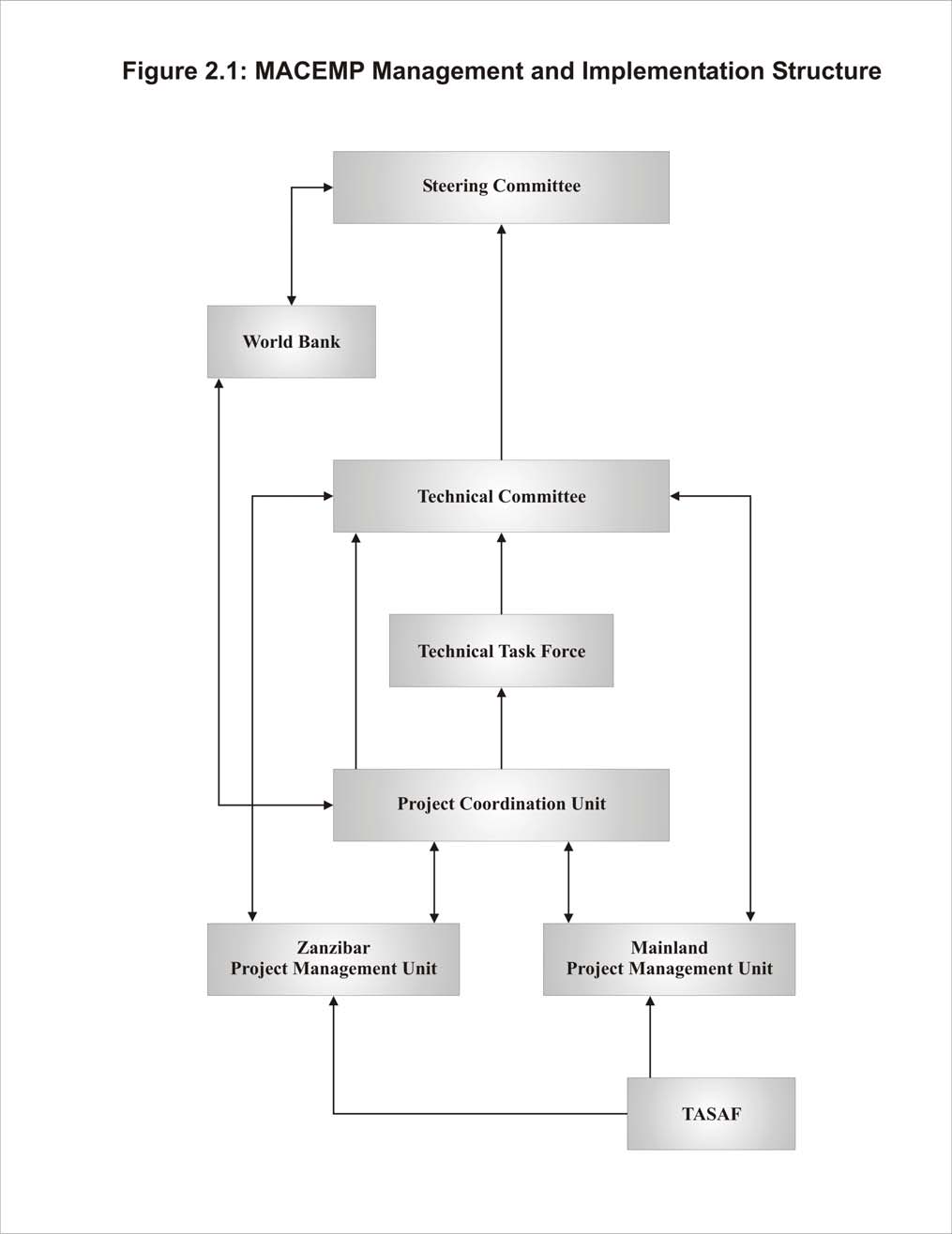
Figure 2.1
MACEMP Management and Implementation Structure
2.2.1
Policies and Legislation for Mainland Tanzania
Table 2.1 lists the relevant coastal and marine resource management policies and legislation applicable to
Mainland Tanzania. General functions of the policies and legislation in management are highlighted, as well
as the direct linkages with MACEMP activities.
MACEMP
ESA
Ę Final Report Ę 24 January 2005
Page 4
Table 2.1
Coastal and Marine Resource Management Policies and Legislation for Mainland
Tanzania
Policy or
Function in Coastal and Marine
Legislation
Resource Management
Linkages with MACEMP
Environmental
Overall management of the potential
Ę Review and approval of environmental impact statements
Management Act
impacts on the environment of coastal
for triggered activities.
(2004)
activities.
Ę Identification of projects or types of projects for which
environmental auditing or monitoring is required, and
ensure compliance with national environmental quality
standards, pollution control and waste management.
Ę Prepare and co-ordinate implementation of Environmental
Action Plans, public awareness and education programmes,
and provision of environmental advice and technical
support.
National
Establishment of the Mainland Tanzania
Ę Defines overall policy objectives with respect to (among
Environmental Policy policy to protect and manage environmental
others): the sustainable, secure and equitable use of
(1997)
assets.
resources; prevention and control of the degradation of land,
water and vegetation; conservation and enhancement of
natural and human-made heritage; improve the condition
and productivity of degraded areas; and raise awareness and
understanding of the linkages between environment and
development, and promote participation in environmental
action.
Marine Parks and
Provides for the establishment, management Ę Consultative process established for the generation and
Reserves Act (1994) and monitoring of marine parks and
modification of general management plans for each MPA.
reserves.
Ę The Act provides individual parks with powers to regulate
activities within its spatial boundaries.
Ę Village Liaison Committees report to the Village Councils,
and serve as the main interface between a park and the local
communities.
Fisheries Act (2003), Provides for protection, conservation, and
Ę Provides for government functions and marine management
and Regulations
regulation and control of fish, fish products,
approaches that support MACEMP activities. Focuses on
and aquatic flora and its products.
management and enforcement of fishing, aquaculture
development, and conservation of fish and fish habitat.
National Fisheries
Policy and strategy statement with respect
Ę Policy support for the conservation and protection of the
Sector Policy and
to the conservation, management and
environment; maximal use of available resources so as to
Strategy Statement
development of fish resources.
increase domestic production; increase opportunity for
(1997)
employment in fisheries; and increase the export of fish
products.
National Integrated
Describes principals and attributes of
Ę Defines strategies and implementing mechanisms,
Coastal Environment integrated coastal management, rationale for
particularly with respect to planning and integrated
Management Strategy a national strategy, and statements of overall
management, conservation, research and monitoring,
(2003)
vision, mission, goal and strategies.
stakeholder participation, and capacity-building for
management.
Forest Act (2002)
Provides for the conservation and
Ę Describes the development and implementation of
management of forests, including mangrove
management plans, community-based forest management
and other coastal forests.
(CBFM) (including both Village Land Forest Reserves,
Community Forest Reserves), and the permitting and
licensing of forest uses.
National Tourism
Describes overall environmental, social,
Ę Defines policy objectives for eco-tourism and cultural
Policy (1999)
economic and cultural objectives, as well as
tourism, including general principles for development with
specific policy strategies, with respect to
respect to development planning, environmental protection,
tourism development in Mainland Tanzania,
impact assessment, and community participation.
including coastal tourism.
Ę Guidelines for Coastal Tourism Development in Tanzania
(2003), but unlikely to apply to MACEMP activities.
Land Act (1999)
Establishes all land as public land vested in Ę Reserved lands under the Act can include marine parks and
the President. Defines categories of land,
reserves.
including general land, reserved land and
Ę Transfer of general or village land can be undertaken, once
village land, which have different resource
the required authority has been provided.
management regimes.
Ę Right of long-term occupancy is protected.
Village Land Act
Defines and determines border demarcation Ę Village lands fall under the management of the Village
(1999)
for village land, on which coastal resources
Council.
will be managed by the village government. Ę MACEMP projects on village land will require agreement
Ensures that the principle of sustainability is
by village government and local authorities.
upheld on village land.
MACEMP
ESA
Ę Final Report Ę 24 January 2005
Page 5
2.2.2
Policies and Legislation for Zanzibar
Table 2.2 lists the relevant coastal and marine resource management policies and legislation applicable to
Zanzibar.
Table 2.2
Coastal and Marine Resource Management Policies and Legislation for Zanzibar
Policy or
Function in Coastal and Marine
Legislation
Resource Management
Linkages with MACEMP
Environmental
Overall management of the potential
Ę EIA screening, and review and approval of environmental
Management for
impacts on the environment of coastal
impact statements for triggered activities.
Sustainable
activities, including ensuring the
Ę Establishment of national environmental standards,
Development Act
environmentally sound and healthy quality
guidelines and codes of good environmental practice.
(1996), and
of life of the people of Zanzibar, promoting Ę Ensure compliance with environmental standards, pollution
Regulations
the sustainable use of renewable natural
control and waste management.
resources, preservation of biological and
Ę Preparation of Environmental Action Plans, Community
cultural diversity, and strengthening
Environmental Management Plans, and Integrated Coastal
institutional capabilities for protecting the
Area Management Plans.
environment.
Ę Establishment of a national protected areas system.
National
Establishment of the Zanzibar policy to
Ę Defines overall policy objectives with respect to (among
Environmental Policy protect and manage environmental assets.
others): development of a programme of integrated coastal
for Zanzibar (1992)
zone management, conservation of indigenous plants and
animals, and conservation of cultural heritage.
The Establishment of Establishment of the semi-autonomous body Ę Unit to manage nature conservation areas or national
Zanzibar Nature
with the purpose of conserving terrestrial,
protected areas; to build the capacity for nature
Conservation Areas
aquatic or marine ecosystems through the
conservation and management of nature conservation areas;
Management unit Act establishment and management of nature
to advise, educate and promote the private sector, local
(1999)
conservation areas.
communities, and government departments on issues
concerning nature conservation; and to educate the public
on the importance of nature conservation.
Fisheries Act (1988), Provides for protection, conservation, and
Ę Provides for government functions and marine management
and Regulations
regulation and control of fish, fish products,
approaches consistent with MACEMP activities. Focuses
(1993)
and aquatic flora.
on management and enforcement of fishing, aquaculture
development, and conservation of fish and fish habitat
(including establishment of parks and sanctuaries).
Fisheries Policy
Policy and strategy statement with respect
Ę Policy support for: increasing the fish catch; promote
(1985)
to the conservation, management and
fishers to fish offshore; ensure the availability of affordable
development of fish resources.
fishing materials; exploit offshore resources; increase
aquaculture production; establish adequate cold storage
facilities; improve the economic condition of fishers;
promote conservation of the marine environment; promote
integrated coastal zone management; promote efficient
marketing; and promote the production and marketing of
seaweed.
Forest Resources
Established to promote the protection,
Ę Provides a means for managing coastal forest resource use.
Management and
conservation and development of forest
Ę Formation of Community Forest Management Areas
Conservation Act
resources for the social, economic and
involves the participation of local communities in
(1996)
environmental benefits of the people of
establishing management agreements, management
Zanzibar.
activities, the rules of use, and the delegation of
management responsibilities to local community groups.
National Forest
Relevant goals of policy include:
Ę Focus includes the development of community forest
Policy for Zanzibar
strengthening the role of forestry in
policies (production and income generation, and
(1995)
alleviating poverty and increasing equity in
involvement of communities in planning and management),
resource management and utilisation; and
and conservation and management of mangrove resources
protecting and conserving forest resources
as part of ICM.
including wildlife and flora, and enhancing
the role of forest resources in maintaining
soil and water conservation and other
environmental benefits.
Zanzibar Tourism
Describes the vision and mission of tourism Ę Defines policy strategies with respect to tourism and the
Policy (2004)
development in Zanzibar, which is highly
environment, and culture and traditions.
dependent on the use of the coastal zone.
Ę Describes general approaches for achieving local benefits
Supports Tourism Zoning Plan to further
and community participation.
guide development.
Land Tenure Act
Establishes all land as public land vested in Ę Ownership of trees on a property is separate from the right
(1992) and Land
the President, and administered by the
of occupancy.
Tenure (Amendment) Minister responsible for land affairs. It
Ę No person may destroy or misuse land.
Act (2003)
defines rights of occupancy of land,
Ę Any person doing research or any activity affecting land in
granting and leasing of public land. Makes
Zanzibar is required to provide the Government with
provision for protection of land resources.
information on request.
MACEMP
ESA
Ę Final Report Ę 24 January 2005
Page 6
2.2.3
Policies and Legislation Applicable to both Mainland Tanzania and Zanzibar
Table 2.3 lists the relevant coastal and marine resource management policies and legislation applicable to both
Mainland Tanzania and Zanzibar.
Table 2.3
Coastal and Marine Resource Management Policies and Legislation Applicable to both
Mainland Tanzania and Zanzibar
Policy or
Function in Coastal and Marine
Linkages with MACEMP
Legislation
Resource Management
Territorial Sea and
Provides for the implementation of the Law Ę Asserts the rights of the URT to control, within the
Exclusive Economic of the Sea Convention, and establishes the
Territorial Seas and EEZ: exploration or exploitation of
Zone Act (1989)
Territorial Sea and Exclusive Economic
resources; research; drilling, constructing or operation of
Zone (EEZ) of the URT.
any structure or device; and any economic activity.
Deep Sea Fishing
Legal establishment of the Deep Sea
Ę May provide legal foundation for sound management of the
Authority Act (1998) Fishing Authority to regulate deep sea
EEZ by establishing a common governance regime for the
fishing (and other uses) in the EEZ.
EEZ.
2.2.4
International Agreements
Table 2.4 lists the international agreements relevant to coastal and marine resource management in the URT,
identifying those on which the URT is a signatory country. All government-supported projects should be
consistent with these international obligations. In some cases, there are clear linkages to MACEMP activities
in support of the fulfilment of the international agreements.
Table 2.4
International Agreements Relevant to Coastal and Marine Resource Management in
the URT
International
Relevance to Coastal and Marine
Agreement
Resource Management
Linkages with MACEMP
Convention on
Framework agreement for the conservation Ę Achievement of MACEMP objective to improve the
Biological Diversity
and sustainable use of biological resources,
management of coastal and marine resources will
(1992)
and includes general provisions in support
contribute to the conservation of biological diversity.
of marine conservation. The URT
subsequently developed a National
Biodiversity Strategy and Action Plan
(2000), and Mainland Tanzania developed
the Coastal Biodiversity Conservation
Strategy (1995).
Cartagena Protocol on Supplementary agreement of the Convention Ę MACEMP aims to protect the marine environment. This
Biosafety (2000)
on Biological Diversity. The Protocol seeks
will include protection against perceived detrimental
to protect biological diversity from potential
genetically modified organisms.
risks that may be posed by living modified
organisms resulting from modern
biotechnology. These may include marine
organisms.
Convention on
Restricts the trade of endangered species,
Ę Development of fisheries through MACEMP activities,
International Trade on including some marine and coastal species
including changes to the management of the EEZ, must
Endangered Species
in the URT. In support, URT signed the
exclude any trade of endangered species.
(CITES) (1979)
Regional Lusaka Agreement (1994) on co-
operative enforcement operations directed at
illegal trade in wild fauna and flora.
Convention on the
Convention addresses species that migrate
Ę There are migratory marine species that will be
Conservation of
across one or more national jurisdictional
potentially impacted by MACEMP Ł in particular,
Migratory Species of
boundary. States are to take co-operative
Dugong is a listed species under the convention.
Wild Animals (1979)
and appropriate necessary steps to conserve
such species and their habitat, through
research, provision of protection, and
conservation and management agreements.
Convention Concerning To identify and protect cultural and natural
Ę Potential MACEMP sites (i.e., ruins of Kilwa Kisiwani
the Protection of the
heritage sites of outstanding and universal
and Songo Mnara) are recognised World Cultural
World's Cultural and
value.
Heritage Sites.
Natural Heritage (the
World Heritage
Convention) (1977)
MACEMP
ESA
Ę Final Report Ę 24 January 2005
Page 7
Table 2.4
International Agreements Relevant to Coastal and Marine Resource Management in
the URT
International
Relevance to Coastal and Marine
Agreement
Resource Management
Linkages with MACEMP
Convention on
Promotion of the conservation and wise use Ę Members are required to manage wetland sites in such a
Wetlands of
of wetlands by national action and
way as to avoid changes in their ecological character.
International
international co-operation. Takes into
Importance
account a wide range of wetland types,
(RAMSAR) (2000)
functions and values, and encourages
adoption of an integrated management
approach.
United Nations
Enables nations to manage and regulate use Ę Allows for the development of URT-based regulation and
Convention on the Law of marine resources to a distance of 200 nm.
management of the EEZ, and the natural resources within
of the Sea (1985)
it.
Convention for the
Aims to ensure sound environmental
Ę MACEMP activities support the URT's commitment to
Protection,
management of the maritime and coastal
achieve the objectives of the convention, and are
Management and
areas of the East African region. Provides a
consistent with the elements of the convention.
Development of the
framework for the protection and
Marine and Coastal
development of marine and coastal
Environment of the
resources. Protocols developed under the
Eastern African Region convention focus on the conservation of
(the Nairobi
flora and fauna, and on measures for
Convention) and
combating marine and coastal pollution.
Related Protocols
(1996)
International
Aims to protect the marine environment
Ę The marine and coastal environment of the URT is
Convention on Oil
from oil pollution, particularly from ships,
threatened by oil pollution. Tanzania has developed a
Pollution Preparedness, offshore units, sea ports and oil handling
National Contingency Plan that may be linked to some of
Response and Co-
facilities.
the MACEMP activities.
operation (1990)
Basel Convention on
Aims to reduce transboundary movements
Ę Although peripheral to MACEMP, the transportation of
the Control of
of hazardous wastes to a minimum
hazardous waste by sea could impact the marine
Transboundary
consistent with the environmentally sound
environment should a spill occur.
Movements of
and efficient management of such wastes; to
Hazardous Wastes and minimize the amount and toxicity of wastes
their Disposal (1989)
generated and ensure their environmentally
sound management as closely as possible to
the source of generation; and to assist lesser
developed countries in environmentally
sound management of the hazardous and
other wastes they generate. This includes
waste that may enter the marine
environment, particularly if transported by
sea.
Bamako Convention on Whereas the Basel Convention explicitly
Ę Although peripheral to MACEMP, the transportation of
the Ban of the Import
excludes radioactive wastes within its scope
hazardous waste by sea could impact the marine
into Africa and the
of application, the Bamako Convention has
environment should a spill occur.
Control of
expressly included such wastes within its
Transboundary
regulatory ambit. Again, this Convention
Movement and
prohibits importation or exportation to
Management of
Africa of hazardous substances banned or
Hazardous Wastes
refused registration in the country of
within Africa (1991)
manufacture on account of human health or
environmental concerns.
MACEMP
ESA
Ę Final Report Ę 24 January 2005
Page 8
3.0
PROJECT DESCRIPTION
MACEMP aims to improve management of coastal and marine resources, to enhance the contribution of these
resources to economic growth, to reduce poverty, and to develop the scientific understanding marine and
coastal resources and major threats to them. The Project will:
Ę
Strengthen marine management institutions in Zanzibar and on the Mainland, with a focus on creating a
common governance regime for the Exclusive Economic Zone (EEZ) (Component 1);
Ę
Support coastal area planning and the establishment of a network of marine protected areas (MPAs) and
marine managed areas (MMAs) for conservation of biodiversity and sustainable utilisation of coastal and
marine resources (Component 2); and
Ę
Create an enabling environment for environmentally sustainable investment along the coast
(Component 3).
3.1
Component 1: Sound Management of the EEZ
Component 1 aims to establish and implement a common governance regime for the EEZ that contributes to
long-term sustainable use and management. This will be accomplished by: 1) supporting the creation of a
common governance regime for the EEZ; 2) improving revenue generation from the EEZ; and 3) developing
an EEZ resource management strategy. MACEMP will provide support for activities that contribute to an
integrated system of marine resource management, focusing on institutional capacity building to enable the
development of effective governance. The main implementing and collaborating agencies include the Ministry
of Foreign Affairs, Vice President's Office, MANREC, MNRT, Navy, Tanzanian Fisheries Research Institute
(TAFIRI), Ministry of Lands and Human Development, universities, Ministry of Trade and Industries,
Ministry of Finance, National Environment Management Council (NEMC) and Meteorology Department.
To address these objectives, the component is split into three subcomponents, each with various activities
(Table 3.1).
Table 3.1
Sub-components and Activity Descriptions for Sound Management of the EEZ
Sub-component Activity
Description
Planning Common Governance Regime
Support domestic dialogue on boundaries and governance
for the EEZ
Review legal mandate and policy
Design Marine Legacy Fund (MLF)
Design EEZ resource monitoring strategy
Research and monitoring Ł stock assessment
Implementation of EEZ Common
Boundary delineation
Governance Regime
Training programme Ł operational agencies
Training programme Ł research and monitoring agencies
Infrastructure and equipment
MLF implementation
MLF capitalization
Implement EEZ resource monitoring strategy
Monitoring, control and surveillance (MCS) operations
Developing and Supporting Partnerships
Support international and regional dialogue on boundaries and governance
in EEZ Management
Support private sector dialogue
Support specific investments (e.g., Dar and Zanzibar fish landing ports)
Sub-component 1a Ł EEZ Planning Support. The existing legal framework for Mainland Tanzania and
Zanzibar provides for separate legal regimes in the management and conservation of marine resources.
However, they share the same EEZ and it is in their mutual interest to ensure the sustainable management of
the marine resources. This subcomponent will support the creation of a common governance regime for the
EEZ by:
Ę
Establishing a common EEZ authority capable of decision-making on behalf of the Union.
Ę
Engaging stakeholders to establish an acceptable institutional structure for common governance.
MACEMP
ESA
Ę Final Report Ę 24 January 2005
Page 9
Ę
Reviewing the current legal mandate and policy, with the view to develop a regulatory framework and
establish a legal mandate to ensure that resources are safeguarded.
Ę
Planning a financial sustainability mechanism or Marine Legacy Fund (MLF) for supporting activities in
the EEZ. This will be substantiated by studies on the revenue generation potential, marketing and value-
added supply, and reforming of the taxation and licensing system for revenue retention.
Ę
Developing an EEZ Resource Management Strategy. The strategy will serve as a guide for best
management practices of EEZ resources within the URT, including marine monitoring as an early
warning system for environmental change.
Ę
Developing and supporting research on the status of resources and major threats. This will include
collaboration with regional initiatives such as the South West Indian Ocean Fisheries Programme
(SWIOFP) stock assessment.
Sub-component 1b Ł Implementation of EEZ Common Governance Regime. The subcomponent will
implement the planned common governance regime for the EEZ. It will include implementation of the EEZ
Resource Management Strategy, implementation of the MLF, institutional capacity building, and carrying out
monitoring, control and surveillance (MCS).
With regard to capacity building, key implementing agencies will be supported to improve their infrastructure
and equipment for management. These institutions will also be supported to strengthen their human resource
capacity through on-the-job training, short courses in specialized fields, training at undergraduate and
postgraduate levels, and secondment to institutions in other countries. Capacity building through MCS
operational training is expected to continue with support from MACEMP.
MCS will be one of the main activities of the common governance regime for the EEZ. The current South
African Development Committee (SADC) MCS project in the EEZ is expected to come to an end in 2005 and
will transfer most of its activities to MACEMP for the purposes of continuity. The assistance will cover
patrolling at sea and aerial patrols. MACEMP will also support MCS information and vessel monitoring
systems.
Sub-component 1c Ł Developing and Supporting Partnerships in EEZ Management. This subcomponent
will support:
Ę
International and regional dialogs on boundaries (finalising EEZ boundaries with Comoros and the
Seychelles) and governance. The project will support participation of staff from implementing agencies to
participate in regional initiatives, such as the Indian Ocean Tuna Commission.
Ę
Dialog with the private sector currently involved in or developing business in the harvesting of resources
within the EEZ, with the aim of improving sector sustainability and food security in the URT.
Ę
Specific community investments through upgrading and rehabilitation of local ports and fish market
infrastructure to decrease preventable post-harvest losses (e.g., cooling and storage facilities).
3.2
Component 2: Sound Management of the Coastal and Marine Environment
Component 2 of MACEMP aims to establish and support a comprehensive system of managed marine areas
within the Territorial Seas (12 nm from the coast) of the URT, building on integrated coastal management
strategies that empower and benefit coastal communities.
Specifically, the component aims to: 1) support integrated coastal management (ICM) planning at national and
district levels; 2) support development of a comprehensive, effective and representative system of marine
management areas (MMAs), marine protected areas (MPAs) and community management areas (CMAs); and
3) increase the area under protection within MPAs and CMAs to enable the URT meet commitments made at
the World Park Congress. This component will support activities leading to strengthening capacity of key
MACEMP
ESA
Ę Final Report Ę 24 January 2005
Page 10
agencies involved in marine management, supporting existing and emerging MMAs, MPAs and CMAs, and
encourage cross-border, community and private sector partnerships in marine and coastal conservation.
The primary beneficiaries of this component will be existing MPAs and CMAs, local communities at the
project sites, and implementing and collaborating agencies, including the Marine Parks and Reserves Unit
(MNRT), MANREC, National Protected Areas Board (Zanzibar), Vice President's Office (NEMC, DoE),
District Councils, relevant research institutions, community-based organisations (CBOs), and NGOs.
Component 2 is split into three subcomponents, which are summarised in Table 3.2 and described below.
Table 3.2
Sub-components and Activity Descriptions for Sound Management of the Coastal and
Marine Environment
Sub-component Activity
Description
Integrated Coastal Management Planning
Local government capacity building Ł resource assessment and mapping
Support
Local government capacity building Ł village ICM planning
Local government capacity building Ł development of spatial plans
ICM planning support (Zanzibar)
ICM planning support (Mainland)
National plan for MPAs/CMAs
Implementation of Network of MMAs and General MPA management training
MPAs
Support for existing MPAs, CMAs and MMAs
Support for emerging MPAs, CMAs and MMAs
Support for management of mangrove ecosystems
Support rehabilitation of cultural heritage sites
Developing and Supporting Partnerships in Regional partnerships Ł protected area initiatives
ICM
Community partnerships Ł demonstration pilot projects
Community partnerships Ł expansion pilot projects
Private sector partnerships Ł MSME capacity building
Private sector partnerships Ł credit scheme
Sub-component 2a Ł Integrated Coastal Management Planning Support. This subcomponent is designed to
improve the livelihoods of coastal communities through supporting integrated coastal area planning. This
involves collaborative district and local planning within ICM governance structures developed nationally.
Currently Mainland Tanzania has a National Integrated Coastal Environment Management Strategy with
detailed action plans, but Zanzibar has no established ICM policy. For Zanzibar, the main focus will be to
identify issues for ICM planning, review policies and laws where relevant, and develop ICM action plans.
Both the Mainland and Zanzibar will be supported for developing a national system plan for MMAs, MPAs
and CMAs and implementing area-specific action plans.
Implementation of the national plans will be at a district or local level. MACEMP will provide support for
human and infrastructure capacity building, particularly with regard to implementation of procedures in the
Environmental Management Act (2004). The sub-component will support capacity to review environmental
and social resource assessment procedures (e.g., creating awareness of EIA guidelines). It will include an
awareness-raising programme to local authorities on the importance of ICM planning and implementation.
There will also be capacity building with regard to integrated management at a community level. Specifically,
focus will be on strengthening the capacity of district and village-level environmental committees for
management and planning of shared areas. Support will be provided to develop and implement collaborative
resource management action plans. This may include: 1) identification of areas of collaborative management;
2) resource assessment and mapping; and 3) technical support for communities to formulate and implement
by-laws. Support shall include provision of specific skills, such as negotiation and conflict resolution, as well
as strengthening capacity for vulnerable resource user groups (e.g., women, youth). MACEMP will also
support targeted capacity building by environmental civil organisations directly contributing to the project
objectives.
MACEMP
ESA
Ę Final Report Ę 24 January 2005
Page 11
Environmental education and awareness raising activities are a key element to capacity building. These will
be supported by the Project and will aim to build commitment to the MPA/CMA, increase appreciation for the
importance of local marine resources, develop awareness of threats to related biodiversity and, especially,
their relationships to long-term use values among local communities and the wider public.
Sub-component 2b Ł Implementation of Network of MMAs and MPAs. This subcomponent will support
direct investments and capacity building for local communities in existing and emerging MMAs, MPAs and
CMAs. The objective is to improve protection of threatened habitats and species, and conserve marine and
coastal ecosystems through improvements in management and a reduction in destructive practices. This sub-
component concentrates 90% of its effort on site-specific support, with about 10% allocated to umbrella
support to core institutions.
Site-specific support will be provided for existing MPAs, MMAs and CMAs at five emerging sites, two
mangrove areas at Chwaka Bay and Rufiji, and an unspecified number of cultural heritage sites. MACEMP
support will be used for general MPA management training, development of management plans, establishment
of co-management agreements, and the implementation of plans in the form of boundary demarcation, site
infrastructure, and start-up operations. General management plans are required as guides in the
implementation of the development and conservation activities for both existing and emerging MMAs, MPAs
and CMAs.
Of particular importance to the conservation network are the mangrove sites of the Rufuji Delta (Mainland
Tanzania) and Chwaka-Menai-Jozani (Unguja). MACEMP support will enable marine parks and forestry
departments to address pressures and threats that are facing mangroves in these areas. For the Mainland,
support will be provided to update the existing Mangrove Management Plan, and for Zanzibar, a management
plan will be prepared. Support will also be provided for community-based conservation activities in the
project areas.
Additionally, MACEMP will provide support in raising awareness of the value of cultural heritage. Sub-
project co-financing will be provided to restore or rehabilitate cultural sites. Specific areas that are targeted by
the project during the first two years include: Kilwa, Livingstone House, Maruhubi/Mtoni ruins, Mangapwani
ruins, the cave system at Kiwengwa, Mtende, and Chwaka.
Sub-component 2c Ł Developing and Supporting Partnerships in ICM. Successful ICM is reliant upon the
development of effective co-management structures and partnerships, at the regional and community level,
and with the private sector.
There are important marine biodiversity areas on both the northern and southern boundaries with Kenya and
Mozambique respectively, which require regional co-operation to manage and conserve. Currently, there are
no transboundary conservation initiatives in place that would ensure the protection of areas. The project will
extend support to developing transboundary MMAs.
Strengthening of community partnerships will be done through replicating co-management models currently
piloted in Kilwa and the coastal areas of Zanzibar. Support of the consultative process for developing resource
management plans shall be provided.
In addition, MACEMP will support the creation of an enabling environment for environmentally sustainable
micro, small and medium enterprise (MSME) growth along the coast. Funding will be used to identify local
investment opportunities and constraints. Support will also be extended to local business councils to provide
and disseminate business information to the community. Action plans to improve the business climate will be
developed and implemented and may include: government taxation issues; private sector incentives for
MSMEs; and market assessment and promotion. Facilitation of credit availability will be through support to
MACEMP
ESA
Ę Final Report Ę 24 January 2005
Page 12
NGOs to provide training to potential borrowers, and to local government to facilitate the movement of micro-
lenders to and within the project sites.
The project will also facilitate small lending operations through creating savings and credit co-operative
societies (SACCOSs) and village banks where they do not exist, and strengthening existing SACCOS and
village banks by offering training in SME lending and outreach to members. MACEMP will provide the
resources needed to ensure that implementing agencies have the capacity to implement these activities.
3.3
Component 3: Coastal Community Action Fund
The objective of Component 3 is to empower coastal communities to access opportunities so that they can
request, implement and monitor sub-projects that contribute to improved livelihoods and sustainable marine
management. This will be achieved through the establishment of a Coastal Village Fund, under the Tanzania
Social Action Fund (TASAF II), and the enhancement of coastal community capacity (Table 3.3 and
described below).
Table 3.3
Sub-components and Activity Descriptions for the Coastal Community Action Fund
Sub-component Activity
Description
Coastal Village Fund
Sub-project grants (via TASAF II)
Coastal Community Capacity
MACEMP awareness creation
Enhancement
Coastal community training
Sub-component 3a Ł Coastal Village Fund. Under TASAF, a Coastal Village Fund will be created as a
principal means for households to directly access MACEMP funding. This fund will be used for financing
demand-driven sub-projects aimed at supporting income generation within coastal communities. The
initiatives may include the demand of technical, physical, or social services to support potential community
sub-projects, including alternative income generating activities (AIGAs). The expected output from this sub-
component will be a reduction in poverty and improved quality of life as a result of enhanced enterprise
management capacity and access to financial support.
Sub-component 3b Ł Coastal Community Capacity Enhancement. This sub-component will include
community-driven initiatives aiming at informing people about natural resource management and the need and
benefits from improved practices. It will also include support for initiatives aimed at providing skills needed
to design, implement and effectively manage projects at community levels. Activities will facilitate
participatory community involvement and selection of priorities, as well as training in managerial, budgeting,
and financial accountability for the procurement of goods and materials. It will also focus on strengthening the
capacity of communities to establish linkages with other organizations, particularly CBOs and NGOs
interested in supporting collaborative management activities. A coastal village co-ordinator will be appointed
to assist villages in accessing the TASAF II funding, by identifying possible projects and providing process
support.
3.4
Project Alternatives
The proposed project design resulted from over two years of discussions and negotiations, which included key
ministries from Mainland Tanzania and Zanzibar. Project preparation and associated sector work also
involved numerous workshops and meetings focused on establishing priorities, identifying sites, and
determining the means for best addressing poverty issues in coastal areas. For example, important insights
were received during a one week workshop in Zanzibar in May 2004, as part of preparatory activities. The
workshop included about 60 participants from various levels of government, the donor community, the private
sector, civil society and NGOs. Similar additional workshops were held on the subjects of project
implementation arrangements, and monitoring and evaluation. The resultant approach and design respects the
outcome of this process, and reflects the complementary initiatives of other development partners that have
MACEMP
ESA
Ę Final Report Ę 24 January 2005
Page 13
been active in this area. During this process, several alternative approaches and designs of the Project were
considered, but rejected for the reasons provided below:
Ę
No Project. The coastal districts remain among the poorest in the URT, and MACEMP provides an
opportunity to target these populations directly by acting concurrently on their environmental and
economic vulnerability. Sound management of coastal resources, many of which are over-exploited or
sub-optimally utilized, will contribute directly to improved incomes and to reduced vulnerability to rapid
external change. In addition, increased local empowerment, through enhancing community management
of the resource base and through better definition of coastal and marine property rights and
responsibilities, will in turn lead to more sustainable use of the resource base. Without MACEMP this is
unlikely to occur.
Ę
Direct Budget Support. Because the Project addresses similar themes to those in the National Strategy for
Growth and Reduction of Poverty (NSGRP), one alternative considered was to cast the project in terms
that would be suitable for inclusion within annual NSGRP operations. This alternative was rejected
because: a) a traditional long implementation cycle would better permit targeted interventions;
b) leveraging of Global Environment Facility (GEF) resources is not possible under budget support
initiatives; 3) testing two concurrent development hypotheses relating to the linkages between
environmental integrity and coastal poverty required closer supervision efforts and greater monitoring and
evaluation efforts than is usually possible within budget support.
Ę
No EEZ Governance Component. The original project was conceived to focus on coastal livelihoods,
with no explicit link to far offshore resources within the EEZ. The URT subsequently identified EEZ
governance as a critical complementary objective. Its absence would have undermined the potential
financial sustainability of many of the other initiatives in the coastal areas.
Ę
More Components. Early plans for the Project were more complex, specifying scientific knowledge
management, private sector development, and community planning as separate distinct components. The
separation of these components was rejected when it was determined that it would be more efficient to
integrate these activities within the current component structure.
Ę
Explicit Inclusion of Community-driven Development Sub-projects within MACEMP. This alternative
was rejected when it was determined that the existing TASAF could efficiently accommodate
MACEMP's sub-project delivery requirements with minimal additional cost.
Ę
Single Implementing Agency. Extensive discussions focused on the possibility of having a single
implementing agency within the URT to deal with both the Zanzibar and Mainland Tanzania activities.
Advantages of that arrangement might have resulted in fewer management staff and lower costs. This
alternative was, however, rejected because: a) it may have marginalized some activities on Zanzibar,
which would be contrary to the spirit of the project to promote local empowerment; b) it would have
increased project implementation risks because it may have encountered additional capacity constraints;
and c) other projects (e.g., the Japanese Social Development Fund, JSDF) are using the two implementing
agency model, and it would have been more difficult to co-ordinate activities with those projects.
MACEMP
ESA
Ę Final Report Ę 24 January 2005
Page 14
4.0
PROJECT AREA
Over the course of MACEMP, the Project could potentially involve activities focused anywhere within the
coastal zone or the broader EEZ. Individual sub-project opportunities will be identified as the Project
proceeds, based on results achieved in initially selected project target areas. For the first two years of the
Project, the geographical areas of focus for Component 2 (Sound Management of the Coastal and Marine
Environment) and Component 3 (Coastal Community Action Fund) will include the following (Figure 4.1):
Ę
Rufiji-Kilwa-Mafia Complex;
Ę
Trans-boundary MPA with Mozambique (Mnazi Bay-Ruvuma Estuary area);
Ę
Latham Island;
Ę
Mnemba Island Marine Conservation Area;
Ę
Menai Bay Marine Conservation Area; and
Ę
Pemba Channel Marine Conservation Area (includes Misali Island Conservation Area).
The Mnazi Bay site is of interest within the context of a regional transboundary initiative with Mozambique Ł
a stand-alone project is already in place, financed by UNDP/IUCN/GEF, and will run for approximately two
more years. The existing Misali Island Conservation Area is within the potential Pemba Channel Conservation
Area. Taken as a whole, the above sites broadly represent the primary types of marine environments and
coastal communities that will be impacted by MACEMP over the lifespan of the Project. Additional sites will
be selected as part of the preparation of Annual Work Plans and based on progress and impact in initial target
areas.
4.1
Marine and Coastal Ecosystems
The Tanzania coastline from Tanga to Mtwara stretches between 4o 38' S and 10o 30' S, a distance of about
800 km. The coastal zone extends eastwards from the continental margin, and includes the nearshore islands
off the mainland coast, including the islands and islets of the Mafia-Songo Songo archipelago. The coastal
zone of the Tanzania mainland is approximated to be 30,000 km2 and its continental shelf adds a further
17,500 km2. The approximate size of the EEZ for Tanzania is 223,000 km2.
The marine and coastal ecosystems in the URT are diverse and resource-rich. The following provides a
description of the natural environment of the marine and coastal ecosystems of the URT, based on the reviews
by Wells et al. (2004) and Juma (2004), which provided a review of the current knowledge of the Tanzanian
coastal and marine systems from over 20 sources of information.
4.1.1
Physical Oceanography and Climate
Climate and physical oceanography are dominant factors in determining ecological character of the marine
environment of the URT. The climate of the URT is dominated by the monsoon seasons. The north-east
monsoon predominates from November to February with relatively gentle winds and higher air temperatures
(>30║C). Between June and September, the south-east monsoon predominates with winds blowing more
strongly in the opposite direction and marked by lower air temperatures (< 25║C). Average rainfall for the
coastal area in the URT ranges from 800 mm to 1,200 mm per year.
The dominant current is the East African Coastal Current (EACC), which flows north along the coast, flowing
fastest during the south-east monsoon. At this time of the year, it meets the East African coast at the latitude
of Mtwara, but in the north-east monsoon, the entire systems shifts north and it meets the mainland closer to
the latitude of Mafia Island. The EACC affects primarily offshore waters but also causes down-welling, which
results in a predominance of low nutrient, warm and clear water that encourages the extensive coral growth
and benthic productivity associated with the coast. Tides also create strong currents, particularly as they tend
to be large along much of the coastline (2 m to 4 m).
MACEMP
ESA
Ę Final Report Ę 24 January 2005
Page 15

#
Horohoro
Muheza
Pemba
Figure 4.1
Channel
Area
Tanga #Y
#
Y
Wete
Geographical Areas
Pemba
of Focus for Initial
Island
#
Y
#
Y
Mkoani
MACEMP
Maziwe
Pangani
Sub-Projects
Pangani
Mkwaju#
Mnemba
Unguja Island
Zanzibar
Chumbe Island
#
Y
Matiowiru#
Fungu Yasini
Map Features
#
Y
Bagamoyo
Bagamoyo
Menai Bay
#
Y
District Headquarters
#
Settlement
Bongoyo
Dar-es-Salaam
Sand Beaches
#
Y
Major Roads
Latham Island
#
Rivers
Kimbiji
Coral Reefs
Msorwa
#
Areas of Initial Focus
Current Marine Protected Areas
Mangroves
Coastal Districts
Kibiti
#
Other Districts
Kilindoni
#
Y
UTETE
#
Y
Mafia Island
c
e
a
n
Bathymetry (masl)
Rufiji
0-20 m
Muhoro
#
20 - 100 m
O
100 - 200 m
200 - 500 m
Rufiji - Kilwa - Mafia
500 - 1000 m
Complex
i
a
n
1000 - 2000 m
Mitega
2000 - 3000 m
#
d
> 3000 m
Kilwa Kivinje
I
n
#
Y
# Kilwa Masoko
#
KIzimbani
Kilwa
Scale 1:2,400,000
Mkuru
#
0
40
80
120
Kilometres
Lindi
Lindi
#
Y
Project: NSD18976
Mnazi Bay
Date: January 19, 2005
Mtwara#Y
Mtwara
4.1.2
Marine and Coastal Habitats
The marine and coastal areas have a wide variety of habitats. These include:
Ę
Coral reefs: The coral reefs of URT cover an estimated 3,580 km2, and are found along at least two thirds
of the country's coastline. The areas of greatest concentration are Tanga, Pemba, Unguja, Mafia, the
Songo Songo archipelago, and Mtwara. Fringing and patch reefs predominate and are generally close to
land because of the relative narrowness of the continental shelf. Fringing reefs are narrow (usually 1 to 3
km wide) but may be more extensive where the shelf broadens around islands.
Ę
Mangroves: A total of eight species of mangrove (Avicennia marina, Bruguiera gymnorrhiza, Ceriops
tagal, Heritiera littoralis, Lumnitzera racemosa, Rhizophora mucronata, Sonneratia alba, Xylocarpus
granatum) are found in Mainland Tanzania, with an additional species, Xylocarpus mulluccensis, occuring
in Zanzibar. On the Mainland, mangroves cover about 108,300 ha, while those on Zanzibar cover about
18,000 ha (6,000 ha in Unguja and 12,000 ha in Pemba).
Ę
Seagrass beds: Twelve species of seagrass occur in URT, with the dominant species being
Thalassodendron ciliutum, Thalassia hemprichii and Syringodium isoetifolium. Usually several seagrass
species occur together in mixed vegetation that forms extensive meadows. The area covered by seagrass
beds and the relative species densities in URT are not known. In general, seagrass beds are widely
distributed in intertidal and sub-tidal mud and sand flats and sand bars, coastal lagoons, in sandy areas
around the bases of shallow, patch and fringing reefs and in mangrove creeks exposed to low tide. They
are found in abundance in sheltered areas of the coast in Tanga, the tidal zones fronting the deltas of
Ruvu, Wami and Rufiji rivers and around Kilwa. They also occur in Pemba, Unguja and Mafia Islands.
Ę
Cliffs and rocky shores: Much of the coastline consists of low (4 m high) limestone coral cliffs with
numerous coralline islets, originating from fossilised coral reefs. The cliffs and islets were formed when
reefs were built during the Pleistocene (130,000 years ago) and subsequently exposed by a drop in sea
level. Fossilised coral reefs extend up to 1 km inland in some places.
Ę
Small islands: The URT has numerous small islands dotted along the coast, particularly where the
continental shelf widens. The most remote is Latham Island (<3 ha in area), a weathered fossil coral
island. Most of these islands are uninhabited, although they may be used frequently by fishermen for
camping, and in populated areas are increasingly being used for recreation and tourism. Many
(particularly those off Pemba and Unguja) have remnants of natural coastal forest with endemic species.
Ę
Beaches and dunes: Sandy beaches are a predominant feature of the coast of the URT. Much of the
mainland coast is lined with beach, as well as the eastern shore of Unguja. Sandy beaches tend to be very
dynamic ecosystems, and in many parts of the country they change markedly with the season or on
longer-time scales through natural processes of accretion and erosion.
Ę
Estuaries and coastal lagoons: Rivers influence the coast and marine environment by discharging water,
sediments, nutrients and pollutants, and create productive brackish water environments in estuaries. The
main rivers and estuaries include: Umba, Pangani, Msangasi, Wami, Ruvu, Ruaha Mkuu and Rufiji,
Matandu, Mbwemburu, Lukuledi and Ruvuma.
Ę
Tidal flats: Much of the shore is dominated by mud and saline flats, but these habitats have been little
studied. Bare flats are often highly saline and may have few if any large organisms, but often have
abundant invertebrate life, particularly if they are regularly inundated, and thus become important feeding
areas for birds.
MACEMP
ESA
Ę Final Report Ę 24 January 2005
Page 17
Ę
Offshore habitats and neritic zone: The continental shelf of the URT covers about 20,000 km2, the
Territorial Seas cover approximately 36,000 km2, and the EEZ covers about 200,000 km2. For most of
these areas there is very little information. The offshore waters are generally less productive than, for
example, those in Western Africa, largely due to the lack of upwellings. Productivity varies seasonally as
it is dependent on seasonal changes in the growth of phytoplankton, which flourishes when waters are
warm; this is turn ultimately influences the distribution of large pelagic fish (such as tuna, king fish and
marlin) and results in the seasonality of fisheries for these species. However, the inter-relationships
between fish stocks, phytoplankton and physical oceanography in the URT has yet to be studied.
Detailed descriptions of identified valued ecological aspects, including coral reefs, mangroves, seagrass beds,
estuaries and coastal lagoons, and offshore habitats are provided in Section 6 and Appendix C.
4.1.3
Important Species
The dugong, Dugong dugon, is an endangered species on the African continent and is almost extinct in the
URT. It is in Appendix 1 of CITES and is listed on the IUCN Red List as Vulnerable. Information on its
distribution and abundance in the URT is scarce and is mainly in the form of anecdotal reports and incidental
sightings. Dugongs were reported to be relatively abundant and widely distributed prior to the mid-1970s,
with incidental gillnet capture of 3 to 5 animals per day. Now they are very rare, with only 32 sightings in the
whole country between January 2000 to May 2003. The Mafia-Rufiji-Kilwa area has probably the largest
remaining concentration in the country, between Jaja in Rufiji and Somanga in Kilwa. Other relatively recent
sightings include near Moa in Muheza District and in the northern part of Pemba Island.
There is little information on other marine mammals in the URT. Eight species of dolphin have been recorded
and dolphins are often caught accidentally in tuna/billfish/marlin nets, particularly off Nungwi (Unguja). The
most common species are probably the Indo-Pacific bottlenose dolphin, Tursiops aduncus, the Indo-Pacific
humpback dolphin, Sousa chinensis, and the spinner, Stenella longirostris. Menai Bay has a significant
population of 150 resident bottlenose and 75 humpback dolphins. Humpback and other whale species pass
through Tanzanian waters on migration (and may calve in Mnazi Bay).
A wide variety of coastal birds and seabirds are found in the URT, particularly in mangrove forests, intertidal
flats and on rocky cliffs. Open water areas, such as the Zanzibar and Mafia channels and the Indian Ocean
itself, provide rich feeding grounds for true seabirds such as terns, gannets, brown noddies and boobies.
Waders and shorebirds visit the URT in large numbers each year between August and May to feed,
particularly on intertidal flats at low tides. Important bird areas (IBAs), designated by Birdlife International
through a widely accepted scientific process, provide an indication of priority bird conservation areas. Ten
IBAs have been designated along the coast (see Appendix C for details).
All five species of sea turtles found in the West Indian Ocean occur in URT waters: the green turtle, Chelonia
mydas, and the hawksbill turtle, Eretmochelys imbricata, both of which nest, are the most common; the olive
ridley turtle, Lepidochelys olivacea, the loggerhead turtle and the leatherback turtle are occasionally seen. All
species of sea turtles are listed on Appendix 1 of CITES; the green turtle, olive ridley and loggerhead are
categorized by IUCN as Endangered, while the leatherback and hawksbill are classified as Critically
Endangered. In 1988, there was a nesting population of about 300 green turtles and there are thought to be
only about 50 hawksbill nests annually. The olive ridley is a rare visitor nesting in small numbers. Marine
turtles are threatened by habitat destruction, over harvesting for meat and eggs, incidental capture in gillnets,
and disturbance of nesting beaches through construction.
The knowledge of fish species found in URT waters is not comprehensive. However, almost 400 reef species
have been recorded off Mafia Island. Rare and threatened fish include the coelacanth, which has been recently
been discovered in the URT. Seahorses are a group that is an indicator of the health of seagrass beds; many
MACEMP
ESA
Ę Final Report Ę 24 January 2005
Page 18
species under threat globally. Seahorses are known to occur in Mafia, Songo Songo and Mnazi Bay. Sharks
are poorly known but are also thought to be declining in the URT. Anecdotal evidence suggests that Songo
Songo and Mafia may be important fish spawning areas.
Equally little is known about the status and distribution of invertebrates. The threatened coconut crab is an
indicator of relatively undisturbed areas and occurs on Misali and Chumbe, and probably other small islands.
Sea cucumbers have drastically declined throughout the inshore waters of the URT, and MPAs may be their
last available refugia. Many of the commercial species of molluscs are thought to be over-exploited, whether
for food or for their shells, but distribution and abundance data are lacking.
4.1.4
Current Status of Marine Protected Areas and Marine Management Areas
A summary of existing MPAs and marine management areas in Mainland Tanzania and Zanzibar is provided
in Table 4.1. The estimated total coverage of subtidal waters by MPAs is 1,378 km2 (including closed reefs
within the Tanga collaborative fishery management areas). This is equivalent to 7.7% of the continental shelf
(to 200 m depth). The total area of managed marine area is considerably larger as it would include the
collaborative fishery management areas in Muheza, Tanga and Pangani Districts.
Table 4.1
Marine Management Areas in the URT (including MPAs and Local ICM Programmes)
Marine Management Area
Date
Established
Size (km2)
MAINLAND TANZANIA
Maziwe Island Marine Reserve
1981
2.6
Tanga collaborative fishery management areas (total area = 1603 km2, of which 28 km2 is no-
1996-2000 *26.4
take) covering coastal areas of Muheza, Tanga and Pangani Districts; set up as joint initiatives
between local communities and districts; area includes closed reefs and Maziwe Island Marine
Reserve
Saadani National Park: a new protected area, up-grading the previous Game Reserve, and
2004 -
potentially extending protection into the sea
Dar es Salaam Marine Reserves System Ł comprises 4 islands, designated as Marine Reserves
1975 26.0
in 1975, and in 1998 placed under the mandate of MPRU
Kinondoni Integrated Coastal Area Management Programme
2000
Mafia Island Marine Park (total area = 822 km2, of which 75% is marine) Ł multiple use
1995 615.0
marine park with zoning
Rufiji Environmental Management Programme Ł a large programme covering the entire delta,
1998 -
but with a coastal component
Mnazi Bay-Ruvuma Estuary Marine Park (total area = 650 km2) 2000
200.0
ZANZIBAR
Misali Island Conservation Area (total area 23 km2 including terrestrial; no-take = 1.4 km2) Ł
1998 21.6
an NGO and community-managed MPA
Ngezi Forest Reserve (14.4 km2) Ł proposed for re-designation as a Nature Reserve; includes
1959 -
mangroves
Menai Bay Conservation Area Ł a community-managed MPA
1997
470.0
Mnemba Island Conservation Area (no take) Ł privately managed MPA, supported through
2002 0.15
Conservation Corporation Africa
Chumbe Island Coral Sanctuary (all no take) Ł management delegated to a private company
1994
0.3
Kilwengwa Controlled Area Ł established in 2000 but never managed
2000
17.5
Jozani National Park Ł a pilot ICM site and protected forest area, Zanzibar's first national park
2004
-
* Excluding Maziwe Marine Reserve as this is listed separately.
4.2
Communities
4.2.1
Population
Tanzania's coastal region covers approximately 15% of the country's land area and is home to about 21% of
the country's population (Juma 2004). In Mainland Tanzania, the coastal population is an estimated 7.0
million living in 30, 000 km2 of coastal area, with a growth rate of 2 to 6 % (TCMP 2001a). There is extensive
migration in coastal areas from rural communities to larger urban centres. The largest urban centres on the
MACEMP
ESA
Ę Final Report Ę 24 January 2005
Page 19
coastal mainland include Dar es Salaam, Tanga and Mtwara (Table 4.2). Dar es Salaam has the greatest
population density (977 individuals/km2), the population having grown by 83% between 1988 and 2002 (Juma
2004).
In Zanzibar (Unguja Island and Pemba Island), population growth rate is estimated at 3 %, with the greatest
rise in population growth occurring in coastal regions (Juma 2004). In 1993, 45% (745,299) of Zanzibar's
population lived in 63 villages and settlements along the coast (Department of Environment et al. 1997). The
urban population for Zanzibar has increased from 32 % of the total population in 1988, to 40 % of the total in
2002 (Juma 2004).
Table 4.2
Population density for coastal regions of the URT
Region
Land Area (km2) Total
Population Population Density
(#/km2)
Coast 32,407
638,015
20
Dar es Salaam
1,393
1,360,850
977
Lindi 66,046
646,550
10
Mtwara 16,707
889,494
53
Tanga 26,808
1,283,636
48
Unguja 1,464
622,459
260-390
Pemba 868
362,166
Source: Adapted from TCMP (2001b), Juma (2004), and Zanzibar Revolutionary Government (2002).
4.2.2
Households
Households in coastal communities tend to be large families with low per capita incomes and high illiteracy
rates. They have relatively poor access to public services such as water and sanitation, especially in rural
areas. They are faced with poor housing conditions, little to no access to credit and market facilities, few
personal savings, and lack of property ownership (TCMP 2001b). The average size of coastal households is
4.9 persons in Mainland Tanzania, and 5.3 per household in Zanzibar (Lema 2003; Juma 2004). Many coastal
villages, especially on the Mainland, have high fertility rates, countered by a high population migration to
larger urban centres. In Mainland Tanzania, 35% of the households are Muslim, 30% Christian, and 35% have
indigenous beliefs. In Zanzibar, more than 99% of the households are Muslim.
Education levels among coastal communities are low. One quarter of Tanzanian adults have no education and
29% are illiterate. Twice the number of women compared to men having no or little education. Access to
credit and savings is also low, although community-based loan programmes are emerging, including micro-
credit revolving funds (e.g., upatus). Most households that have surplus earnings store their savings in the
house or use it to buy food (Lķon et al. 2004).
Many coastal communities remain relatively isolated due to poor infrastructure such as roads,
communications, electrical service, water supply, and ports. The National Bureau of Statistics household
budget survey in 2000-2001 indicated that 2% of households in rural areas have electricity, 6% have bank
accounts, 25% have modern walls, and 45% need to travel more than 1 km for drinking water.
Access to health resources remains an issue for coastal households, with the demand for social services being
directly related to a lack of safe drinking water, and access to medical facilities being hampered by a need for
infrastructure investments. The average distance for communities to access hospital facilities ranges from 29
km in Tanga to 2.8 km in Dar es Salaam (Table 4.3). Life expectancy in coastal regions is 47 years for men
and 50 years for women; this is marginally greater than the national average of 44.56 yrs. Infant mortality
remains high in coastal areas with a large number of malnutrition cases among children under five. The most
common disease in coastal areas is malaria, affecting 69% of children and 60% of adults (Juma 2004).
Records for Zanzibar indicate that malaria was responsible for 48% of all outpatient services in 1999 (ZMCP
2001). Households in coastal communities are also faced with other notable diseases including HIV/AIDS,
cholera, and schistosomiasis.
MACEMP
ESA
Ę Final Report Ę 24 January 2005
Page 20
Table 4.3
Household Access to Social Services
Tanga
Coast
Mtwara
Dar es Salaam
Health
Households within 6 km of health facility (%)
62
74
87
98
Mean distance to hospital (km)
29
24.5
19.2
2.8
Water
Households with piped/protected drinking water (%)
46
35
52
94
Households within 1 km of drinking water (dry season) (%)
41
56
41
84
Source: TCMP (2003).
Coastal communities in Mainland Tanzania and Zanzibar are highly dependent on natural resources extraction
for their livelihood activities. Traditional activities undertaken in coastal communities are based around
subsistence and small-commercial initiatives. These are activities that either provide food or a source of
shelter, or which involve income-generation within the local market. Key activities include: artisanal fisheries,
agriculture and animal husbandry, mariculture, salt and lime production, beekeeping, small-scale trade and
crafts, and mangrove and coastal thicket-related activities. In coastal villages, fishing is the main livelihood
activity for male-headed households, while farming is the main activity for female-headed households (Wells
et al. 2004). A characteristic of households in coastal communities is the necessity to undertake several
livelihood activities simultaneously to supplement incomes and ensure a consistent food source for family
members.
4.2.3
Social Characteristics of Initial Target Geographic Areas
MACEMP implementation will initially focus on selected target areas of Mainland Tanzania and Zanzibar. In
support of the impact assessment of MACEMP activities focused in these areas, the specific social
characteristics of the Kilwa District, Rufiji District, Mafia District, Mtwara District, Pemba Island, Unguja
Island, and Latham Island (see Figure 4.1) are considered. This description is provided in Appendix D.
MACEMP
ESA
Ę Final Report Ę 24 January 2005
Page 21
5.0
IMPACT ASSESSMENT METHODOLOGY
5.1
Selection of Valued Aspects
The issues scoping process for this impact assessment involved the following:
Ę
A review of background documents prepared for the Project, including the draft Project Implementation
Manual (PIM) and the draft Situation Analysis documenting existing information relating to social and
environmental circumstances important to MACEMP;
Ę
A review of documents prepared for previous development projects or as part of independent scientific
research in the United Republic of Tanzania;
Ę
A scoping workshop with key stakeholders and government agency representatives;
Ę
Observations from field visits conducted by the study team as part of the consultation programme (see
Section 9); and
Ę
Follow-up consultations with government (i.e., MNRT and MANREC) and the WB Task Team.
The information collected and comments received were used to identify the valued aspects for the impact
assessment, and prioritise them as being of "high", "moderate" or "low" priority. For the purposes of the ESA,
those of low priority were not assessed further. Valued aspects were given a low priority if:
1. There is a weak causal link (direct or indirect) between any MACEMP activity and potential impacts on
the valued aspect in question;
2. The valued aspect is a low policy priority within the URT; and/or
3. All identified potential impacts on the valued aspect are positive, but indirect.
The last selection criterion, in particular, was necessary in order to appropriately focus the ESA. MACEMP is
a broad-based project that is anticipated to have numerous indirect, positive impacts on many environmental,
socio-cultural, economic and institutional aspects throughout the URT. A full assessment of these is not
required to ensure MACEMP is compliant with WB Safeguards and URT environmental assessment policies
and legislation.
A valued aspect was categorised as being of moderate priority where there is the potential for negative
impacts or direct positive impacts, but where the valued aspect is not likely a priority investment area for
MACEMP (based on either the Project Description or as indicated by demand as revealed through the ESA
consultation process) or is not currently a prominent activity in the marine or coastal environment. Valued
aspects categorised to be moderate priority were assessed in the ESA, but were grouped with other aspects that
could be similarly treated. The same applied to valued aspects that were rated as high priority and were similar
in nature (e.g., coral reefs, seagrass beds and offshore habitats are grouped together as marine ecosystems).
The appropriate selection of valued aspects ensured that the issues of greatest importance were addressed, and
reflects an informed understanding of the existing conditions within the URT, as well as the environmental
and social importance of specific valued aspects. The identified valued aspects, with their associated priority
ratings, are shown in Table 5.1.
MACEMP
ESA
Ę Final Report Ę 24 January 2005
Page 22
Table 5.1
Identified Valued Aspects
Priority
Scoping
Considerations
(high, moderate
or low)
Valued Environmental Aspects
Coral Reefs
Ę Potential direct positive impact.
High
Ę Management of marine resources a priority investment area for
MACEMP Ł assess jointly with other marine aspects as "Marine
Ecosystems".
Seagrass Beds
Ę Potential direct positive impact.
High
Ę Management of marine resources a priority investment area for
MACEMP Ł assess jointly with other marine aspects as "Marine
Ecosystems".
Offshore Habitat and Neritic
Ę Potential direct positive impact.
High
Zone
Ę Management of marine resources a priority investment area for
MACEMP Ł assess jointly with other marine aspects as "Marine
Ecosystems".
Mangrove Forests
Ę Potential direct positive impact.
High
Ę Management of coastal resources a priority investment area for
MACEMP Ł assess jointly with other coastal aspects as "Coastal
Ecosystems".
Sandy Beaches
Ę Potential direct positive impact.
High
Ę Management of coastal resources a priority investment area for
MACEMP Ł assess jointly with other coastal aspects as "Coastal
Ecosystems".
Important Bird Areas
Ę Potential direct positive impact.
High
Ę Management of coastal resources a priority investment area for
MACEMP Ł assess jointly with other coastal aspects as "Coastal
Ecosystems".
Valued Socio-cultural Aspects
Social Capital
Ę Potential direct positive (long-term) and negative (short-term) impact.
High
Ę Identified for direct investment by MACEMP.
Human Capital
Ę Potential direct positive impact.
High
Ę Priority investment area for MACEMP Ł to be evaluated in the ESA as
part of other identified valued aspects (i.e., individual Valued Economic
Aspects and Valued Institutional Aspects).
Vulnerable Groups
Ę Potential direct positive (long-term) and negative (short-term) impact.
High
Ę Identified for direct investment by MACEMP.
Cultural Property and
Ę Potential direct positive impact.
High
Antiquities
Ę Identified for direct investment by MACEMP.
Human Health and Public
Ę Potential indirect positive impact.
Low
Services
Ę Public health, sanitation and public services not for direct investment by
MACEMP.
Ę Food security impacted through investments in other identified valued
aspects.
Valued Economic Aspects
Commercial and Artisanal
Ę Potential direct positive (long-term) and negative (short-term) impact.
High
Fisheries
Ę Management of fisheries resource a prominent focus for MACEMP.
Tourism
Ę Potential direct positive impact.
High
Ę Management of natural resources, on which tourism is directly
dependent, a prominent focus for MACEMP.
Coastal Forest Resource Use
Ę Potential direct positive impact (long-term) and negative impact (short-
High
term).
Ę Management of coastal forest resource a prominent focus for
MACEMP.
Mariculture
Ę Potential direct positive impact.
High
Ę Management of coastal and marine environment a prominent focus for
MACEMP.
Agriculture and Animal
Ę Potential direct positive impact.
Moderate
Husbandry
Ę Not likely a priority investment area for MACEMP Ł incorporate
assessment with "Other Livelihood Activities".
Salt Production
Ę Potential direct positive impact.
Moderate
Ę Not likely a priority investment area for MACEMP Ł incorporate
assessment with "Other Livelihood Activities".
Small-scale Trade and
Ę Potential direct positive impact.
Moderate
Handicrafts
Ę Not currently a prominent activity in the coastal zone Ł incorporate
assessment with "Other Livelihood Activities".
MACEMP
ESA
Ę Final Report Ę 24 January 2005
Page 23
Table 5.1
Identified Valued Aspects
Priority
Scoping
Considerations
(high, moderate
or low)
Heavy Industry
Ę Heavy industry (primarily in Dar es Salaam and Tanga) and offshore
Low
natural gas development and exploration operating in the coastal zone,
but highly localised.
Ę Not a sector for investment by MACEMP.
Valued Institutional Aspects
National and Local
Ę Potential negative impact (restricted capacity to participate effectively in
High
Government
MACEMP and to monitor adequately).
NGOs, CBOs and the Private
Ę Potential negative impacts (on current operations, and capacity to
High
Sector
participate effectively in MACEMP and to monitor adequately.
5.2
Potential Impacts of the Project on Valued Aspects
Based on the results of the scoping process, impact matrices (Tables 5.2, 5.3 and 5.4) were developed to
identify potential impacts of the three Project components on identified valued aspects. The identification of
the potential impacts is based on consideration of the specific activities described in Section 3. A potential
impact does not necessarily indicate a predicted impact, but warrants further analysis. The specific nature of
the impacts is evaluated and discussed in subsequent sections of this report.
Each identified potential impact shown on Tables 5.2, 5.3 and 5.4 was coded according to the following:
N = negative impact (direct or indirect);
P = direct positive impact; or
N/P = both negative and positive impacts.
The selection of the valued aspects and identification of the potential impacts were detailed in a scope of work
document and submitted to the MNRT and MANREC for government review and comment prior to
completion of the impact evaluation.
5.3
Impact Evaluation
The impact evaluation was based on an analysis of the impacts of the Project on the existing environment. A
description of the existing conditions for each valued aspect was provided as a basis for the evaluation of
impacts. The existing conditions focused on characteristics relevant to the potential project impacts within the
temporal and spatial boundaries defined for the assessment.
For the purposes of the ESA, the temporal boundaries were defined from project implementation (mid-2005)
to the end of the six-year funding commitment (2011). For environmental aspects, the applied spatial
boundaries were defined as all coastal ecosystems within Zanzibar (Pemba and Unguja) and the Government
Districts along coastal Mainland Tanzania, and all marine ecosystems within the EEZ. For socio-cultural and
economic aspects, the applied spatial boundaries were all coastal communities that will potentially be directly
or indirectly affected by MACEMP activities. This is primarily coastal communities that currently utilise
marine resources. For institutional aspects, the applied boundaries were government, NGO and private sector
institutions that will potentially be involved in or affected by MACEMP activities.
MACEMP
ESA
Ę Final Report Ę 24 January 2005
Page 24
Table 5.2
Summary of Potential Impacts of Component 1 (Sound Management of the EEZ) on Valued Aspects
ups
d
erty
o
cal
ystems
y
s
tems
t
and
ties
L
Project Sub-Component and
op
i
h
oo
t
or
c
os
le Gro
nt
Activity
Characteristics of Potential Impacts
Ecos
E
b
Pr
i
vel
and
al
tiqui
t
ure
al
tal
n
mercial and
a
nal Fisheries
tal Fores
L
on
s
, CBOs
as
t
ur
A
vities
urism
as
ti
Marine
Co
Social Capital
Vulnera
Cul
and
Com
Artis
To
Co
Resource Use
Maricul
Other
Acti
Na
Governme
NGO
Private Sec
Planning Common Governance Regime for the EEZ
Support domestic dialogue on
boundaries and governance
Ł Ł Ł Ł Ł Ł Ł Ł Ł Ł P Ł
No negative impacts anticipated.
Review legal mandate and policy
Ł
Ł
Ł
Ł
Ł
Ł
Ł
Ł
Ł
Ł
P
Ł
No negative impacts anticipated.
Design Marine Legacy Fund
(MLF)
Ł Ł Ł Ł Ł Ł Ł Ł Ł Ł P Ł
Impact assessment for design phase only. Implementation to be
assessed as part of separate MACEMP sub-component.
Design EEZ resource monitoring
strategy
Ł Ł Ł Ł Ł Ł Ł Ł Ł Ł P Ł
Impact assessment for design phase only. Implementation to be
assessed as part of separate MACEMP sub-component.
Research and monitoring Ł stock
assessment
Ł Ł Ł Ł Ł Ł Ł Ł Ł Ł P Ł
Increase in baseline information should increase efficacy of EEZ
management.
Implementation of EEZ Common Governance Regime
Boundary delineation
Ł Ł Ł Ł Ł Ł Ł Ł Ł Ł P P
Potential to increase certainty in planning for management and
operations.
Training programme -
operational agencies
Ł Ł Ł Ł Ł Ł Ł Ł Ł Ł P Ł
Increase in government capacity should increase efficacy of EEZ
management.
Training programme Ł research
and monitoring agencies
Ł Ł Ł Ł Ł Ł Ł Ł Ł Ł P Ł
Increase in government capacity should increase efficacy of EEZ
management.
Infrastructure and equipment
Ł Ł Ł Ł Ł Ł Ł Ł Ł Ł P Ł
Increase in government capacity should increase efficacy of EEZ
management.
MLF implementation
Potential negative impacts on fisheries with increase in rent
capture and financial incentive for illegal fishing.
Ł Ł Ł Ł Ł N Ł Ł Ł Ł P Ł
Longer-term indirect positive impacts on fisheries through better
management of the resources.
Secured long-term government financing mechanisms should
increase efficacy of EEZ management.
MLF capitalization
Ł Ł Ł Ł Ł Ł Ł Ł Ł Ł P Ł
Increase in government capacity should increase efficacy of EEZ
management.
Implement EEZ resource
monitoring strategy
Ł Ł Ł Ł Ł Ł Ł Ł Ł Ł P Ł
Increase in monitoring information should increase efficacy of
EEZ management.
Monitoring, control and
Potential negative impacts on commercial fisheries with
surveillance (MCS) programme
restrictions in access, and increased costs to comply with MCS
Ł Ł Ł Ł Ł N Ł Ł Ł Ł P Ł
requirements.
Increase in monitoring information should increase efficacy of
EEZ management.
MACEMP
ESA
Ę Final Report Ę 24 January 2005
Page 25
Table 5.2
Summary of Potential Impacts of Component 1 (Sound Management of the EEZ) on Valued Aspects
ups
d
erty
o
cal
ystems
y
s
tems
t
and
ties
L
Project Sub-Component and
op
i
h
oo
t
or
c
os
le Gro
nt
Activity
Characteristics of Potential Impacts
Ecos
E
b
Pr
i
vel
and
al
tiqui
t
ure
al
tal
n
mercial and
a
nal Fisheries
tal Fores
L
on
s
, CBOs
as
t
ur
A
vities
urism
as
ti
Marine
Co
Social Capital
Vulnera
Cul
and
Com
Artis
To
Co
Resource Use
Maricul
Other
Acti
Na
Governme
NGO
Private Sec
Developing and Supporting Partnerships in EEZ Management
Support international and
No negative impacts anticipated.
regional dialogue on boundaries
Ł Ł Ł Ł Ł Ł Ł Ł Ł Ł P P
and governance
Support private sector dialogue
Ł
Ł
Ł
Ł
Ł
Ł
Ł
Ł
Ł
Ł
P
P
No negative impacts anticipated.
Support specific investments
Assumes specific community investments under this activity will
(e.g., Dar and Zanzibar fish
Ł Ł Ł Ł Ł P Ł Ł Ł Ł Ł Ł
be focused on fisheries.
landing ports)
N = negative impact (direct or indirect); P = direct positive impact.
MACEMP
ESA
Ę Final Report Ę 24 January 2005
Page 26
Table 5.3
Summary of Potential Impacts of Component 2 (Sound Management of the Coastal and Marine Environment) on
Valued
Aspects
ups
d
erty
o
cal
ystems
y
s
tems
t
and
ties
L
Project Sub-Component
op
i
h
oo
t
or
c
os
le Gro
nt
and Activity
Characteristics of Potential Impacts
Ecos
E
b
Pr
i
vel
and
al
tiqui
t
ure
al
tal
n
mercial and
a
nal Fisheries
tal Fores
L
on
s
, CBOs
as
t
ur
A
vities
urism
as
ti
Marine
Co
Social Capital
Vulnera
Cul
and
Com
Artis
To
Co
Resource Use
Maricul
Other
Acti
Na
Governme
NGO
Private Sec
Integrated Coastal Management Planning Support
Local government capacity
Increase in government capacity should increase efficacy of
building Ł resource assessment
Ł Ł Ł Ł Ł Ł Ł Ł Ł Ł P Ł
management.
and capacity mapping
Local government capacity
Increase in government capacity should increase efficacy of
building Ł village ICM planning
Ł Ł P Ł Ł Ł Ł Ł Ł Ł P Ł
management.
Potential direct positive impacts on social capital with improved
linkages with village-level governance.
Local government capacity
Increase in government capacity should increase efficacy of
building Ł development of
Ł Ł Ł Ł Ł Ł Ł Ł Ł Ł P Ł
management.
spatial plans
ICM planning support (Zanzibar)
Ł Ł Ł Ł Ł Ł Ł Ł Ł Ł P P
Advancement of government planning should increase efficacy of
management.
ICM planning support
(Mainland)
Ł Ł Ł Ł Ł Ł Ł Ł Ł Ł P P
Advancement of government planning should increase efficacy of
management.
National plan for MPAs/CMAs
Ł Ł Ł Ł Ł Ł Ł Ł Ł Ł P P
Advancement of government planning should increase efficacy of
management.
Implementation of Network of MMAs and MPAs
General MPA management
training
Ł Ł Ł Ł Ł Ł Ł Ł Ł Ł P P
Increase in government and NGO/CBO capacity should increase
efficacy of management.
Support for existing MPAs,
Potential negative impacts on social capital if planning and
CMAs and MMAs
implementation not integrated with local decision-making processes.
Potential negative impacts on vulnerable groups.
P P N N Ł N/P Ł N/P N/P N/P N N
Potential negative impacts on resource users (i.e., fisheries, coastal
forests, mariculture and other livelihood activities), while longer-term
impacts expected to be positive with improved resource management.
Potential negative impacts on government and NGO/CBO partners if
capacity not adequate.
MACEMP
ESA
Ę Final Report Ę 24 January 2005
Page 27
Table 5.3
Summary of Potential Impacts of Component 2 (Sound Management of the Coastal and Marine Environment) on
Valued
Aspects
ups
d
erty
o
cal
ystems
y
s
tems
t
and
ties
L
Project Sub-Component
op
i
h
oo
t
or
c
os
le Gro
nt
and Activity
Characteristics of Potential Impacts
Ecos
E
b
Pr
i
vel
and
al
tiqui
t
ure
al
tal
n
mercial and
a
nal Fisheries
tal Fores
L
on
s
, CBOs
as
t
ur
A
vities
urism
as
ti
Marine
Co
Social Capital
Vulnera
Cul
and
Com
Artis
To
Co
Resource Use
Maricul
Other
Acti
Na
Governme
NGO
Private Sec
Support for emerging MPAs,
Potential negative impacts on social capital if planning and
CMAs and MMAs
implementation not integrated with local decision-making processes.
Potential negative impacts on vulnerable groups.
P P N N Ł N/P Ł N/P N/P N/P N N
Potential negative impacts on resource users (i.e., fisheries, coastal
forests, mariculture and other livelihood activities), while longer-term
impacts expected to be positive with improved resource management.
Potential negative impacts on government and NGO/CBO partners if
capacity not adequate.
Support for management of
Potential negative impacts on social capital if planning and
mangrove ecosystems
implementation not integrated with local decision-making processes.
Potential negative impacts on vulnerable groups.
Ł P N N Ł Ł Ł N/P
N/P
N/P
N N
Potential shorter-term negative impacts on resource users (i.e., coastal
forests, mariculture and other livelihood activities), while longer-term
impacts expected to be positive with improved resource management.
Potential negative impacts on government and NGO/CBO partners if
capacity not adequate.
Support rehabilitation of cultural
Potential negative impacts on social capital if planning and
heritage sites
implementation not integrated with local decision-making processes.
Ł Ł N Ł P Ł P Ł Ł Ł N N
Potential direct positive impact on the state of cultural heritage sites
and associated tourism businesses.
Potential negative impacts on government and NGO/CBO partners if
capacity not adequate.
Developing and Supporting Partnerships in ICM
Regional partnerships Ł
protected area initiatives
Ł Ł Ł Ł Ł Ł Ł Ł Ł Ł P P
Development of partnerships should increase efficacy of
management.
Community partnerships Ł
demonstration pilot projects
Ł Ł P Ł Ł Ł Ł Ł Ł Ł P P
Development of partnerships should increase efficacy of
management, and social capital.
Community partnerships Ł
expansion pilot projects
Ł Ł P Ł Ł Ł Ł Ł Ł Ł P P
Development of partnerships should increase efficacy of
management, and social capital.
Private sector partnerships Ł
MSME capacity building
Ł Ł Ł Ł Ł Ł Ł Ł Ł Ł P P
Development of partnerships should increase efficacy of
management.
Private sector partnerships Ł
credit scheme
Ł Ł Ł Ł Ł Ł Ł Ł Ł Ł P P
Development of partnerships should increase efficacy of
management.
N = negative impact (direct or indirect); P = direct positive impact.
MACEMP
ESA
Ę Final Report Ę 24 January 2005
Page 28
Table 5.4
Summary of Potential Impacts of Component 3 (Coastal Community Action Fund) on Valued Aspects
ups
d
erty and
o
cal
t
Project Sub-Component
ystems
y
s
tems
L
and
op
i
h
oo
t
or
and Activity
c
os
Characteristics of Potential Impacts
le Gro
nt
Ecos
E
b
i
vel
and
al Pr
t
ure
al
tal
mercial and
a
nal Fisheries
tal Fores
L
on
s
, CBOs
as
vities
urism
as
ti
Marine
Co
Social Capital
Vulnera
Cultur
Antiquities
Com
Artis
To
Co
Resource Use
Maricul
Other
Acti
Na
Governme
NGO
Private Sec
Coastal Village Fund
Sub-project grants (via TASAF
Potential negative or positive impacts on marine and coastal
II)
N/P N/P N/P N/P N/P N/P N/P N/P N/P N/P Ł Ł ecosystems, social capital, vulnerable groups, cultural property
and antiquities, and all identified livelihood activities, depending
on the nature of the specific sub-project.
Coastal Community Capacity Enhancement
MACEMP awareness creation
Ł Ł P P Ł Ł Ł Ł Ł Ł Ł Ł
Potential direct positive impacts on village-level social capital
and vulnerable groups through outreach activities.
Coastal community training
Ł Ł P P Ł Ł Ł Ł Ł Ł Ł Ł
Potential direct positive impacts on village-level social capital
and vulnerable groups through building of community capacity.
N = negative impact (direct or indirect); P = direct positive impact.
MACEMP
ESA
Ę Final Report Ę 24 January 2005
Page 29
Potential impacts on valued environmental, socio-cultural, economic and institutional aspects were evaluated
based on application of specific criteria to each identified potential impact. The evaluation criteria included
the following:
Ę
Intensity. The strength of the impact.
Ę
Geographic extent. The spatial extent of the area impacted.
Ę
Duration. The time during which the impact continues.
Ę
Frequency. The rate of the occurrence, or the time it takes for the impact to repeat.
Ę
Reversibility. The ability of the system to return to the existing condition, as defined by the system
elements, structures and functions, prior to the impact.
Ę
Thresholds. The system may currently be operating near a threshold or point of criticality, whereby being
pushed beyond this critical point results in substantial or drastic changes. Alternatively, specific
environmental standards, guidelines or objectives may be exceeded.
For the assessment of environmental aspects (and not socio-cultural, economic and institutional aspects) two
addition important criteria were applied:
Ę
Resiliency. The speed and ease at which the system returns to the existing condition, as defined by the
system elements, structures and functions, prior to the impact.
Ę
Rarity. Specific impacted elements within the system may be rare or endangered.
For the assessment of socio-cultural, economic and institutional aspects (and not environmental aspects) two
addition important criteria were applied:
Ę
Equity. Specific groups may be negatively impacted more than others. Similarly, certain groups may
benefit more than others from the Project or related development opportunities. In other words, impacts
may not be impartial.
Ę
Opportunities and constraints. Impacts may substantially restrict or enhance future development options
or opportunities. There may be socio-economic or institutional constraints that reduce positive impacts or
enhance negative impacts.
For each criterion, impacts were described and weighting was qualitatively applied, forming the basis for the
evaluation. A distinction was made between direct and indirect impacts. Impacts were then identified as
significantly adverse, adverse (non-significantly), or positive. For each identified impact, the probability or
likelihood of occurrence was characterised. Uncertainties, information gaps (unknowns), and data quality
issues were similarly described, as applicable.
An examination of potential cumulative impacts was also part of the assessment. Cumulative impacts may
occur where there are indirect, synergistic or complex interactions with other projects. This includes those
both ongoing and planned (i.e., projects that are occurring or that can be reasonably expected to occur in the
future).
For the purposes of the ESA, the cumulative impact assessment focused on other development programmes
specifically affecting the marine environment, coastal socio-economic conditions or cultural property, and/or
use of the marine environment. The cumulative effects associated with the following were examined:
Ę
The Tanzania Social Action Fund (TASAF II);
Ę
Japan Social Development Fund (JSDP) activities;
Ę
The Local Government Support Programme (LGRP);
Ę
The Participatory Agricultural Development and Empowerment Project (PADEP);
MACEMP
ESA
Ę Final Report Ę 24 January 2005
Page 30
Ę
European Union Programmes;
Ę
Restoration of Cultural Heritage Sites in Mainland Tanzania and Zanzibar;
Ę
The South West Indian Ocean Fisheries Project;
Ę
The Targeted Research Project on Coral Reef Management;
Ę
The Tanzania Coastal Management Partnership (TCMP); and
Ę
The National Strategy for Growth and Reduction of Poverty
5.4
Determination of Mitigation, Monitoring and Evaluation
Appropriate mitigation measures that will reduce the significance of negative impacts on valued aspects were
identified. For each valued aspect, a concluding statement was made regarding the residual impacts of the
Project after the application of the identified mitigation measures.
Monitoring and evaluation was identified, where required, to compensate for uncertainties and information
gaps in the impact assessment and, more generally, to ensure that actual residual negative impacts are no
greater than as predicted in the assessment. Recommendations for monitoring and evaluation were in keeping
with the principle of adaptive management, whereby policies, practices or procedures are adjusted
appropriately during project implementation to improve the efficacy of management strategies and mitigation
measures.
With respect to sub-projects implemented under Component 3 (Coastal Community Action Fund),
environmental assessment process and procedures were described as the appropriate safeguard for evaluating
the potential impacts of individual sub-projects. With respect to MACEMP support for existing and emerging
MPAs under Component 2 (Sound Management of the Coastal and Marine Environment), a PF was provided
as a separate document.
5.5
Information Collection
The description of existing conditions and the effects assessment were based primarily on existing secondary
information, including background documents prepared for the Project, the draft PIM, as well as the draft
Situation Analysis that was prepared to document existing information relating to social and environmental
circumstances important to MACEMP. A review of documents prepared for previous development projects or
as part of independent scientific research in the URT was also conducted. Identification of all relevant
documents was assured through discussions with key stakeholders including government officials, non-
governmental organizations (NGOs), academic institutions, and donor agencies.
An important element of the research was conducting interviews with key stakeholders to validate the
secondary information obtained during the literature and document review. These interviews also allowed the
Project Team to gather additional information on coastal communities and activities to supplement the
available secondary information. A semi-structured interview guide was used to ensure the consistent and
systematic collection of information (Appendix E). Questions covered several topics, including: livelihoods
(existing and alternative livelihoods); consultation and communication processes; conflicts and dispute
resolution; and monitoring and evaluation. A project information description was provided to stakeholders at
the start of each interview. Mapping was also incorporated into the sessions as a valuable means to help the
participants understand the Project, and allow them to identify community resources and activities. These
interviews were not designed to collect information at the level of the household, but targeted individuals that
were particularly knowledgeable of the district in question or of identified valued components, and who could
speak to the issues affecting specific stakeholder groups as a whole.
MACEMP
ESA
Ę Final Report Ę 24 January 2005
Page 31
Several focus group sessions were held in cases where there are several stakeholders within an organization,
or where more than one organization has similar interests in the Project. Focus groups are interactive sessions
where participants are encouraged to provide comment on various topics and develop ideas as a group.
Sessions were facilitated by a member of the Project Team. Discussion topics raised during the focus group
sessions were based on the semi-structured interview guide.
The research was conducted during missions based in Dar es Salaam. However, field visits were made to key
sites to conduct local interviews, expand the document and data search, and make personal observations
regarding the characteristics and local use of sites. The sites included locations within:
Ę
The Rufiji District;
Ę
The Kilwa District;
Ę
Mnazi Bay-Ruvuma Estuary Marine Park and area;
Ę
Mnemba Island Conservation Area;
Ę
Menai Bay Conservation Area; and
Ę
Misali Island Conservation Area.
All sites have been selected for initial targeting by MACEMP. The selected sites represent different levels of
previous marine management intervention, from relatively mature management areas (i.e., Misali Island
Conservation Area) to effectively "greenfield" sites (i.e., within Kilwa District).
MACEMP
ESA
Ę Final Report Ę 24 January 2005
Page 32
6.0
ENVIRONMENTAL AND SOCIAL IMPACT ASSESSMENT
6.1
Valued Environmental Aspects
6.1.1
Marine Ecosystems
Marine ecosystems in the URT, and the resources provided by them, are critical to the well-being of coastal
communities, many of which rely on activities in the marine environment for their livelihood. For this
assessment, marine ecosystems are defined as all natural resource systems from the low water mark to the 200
nm boundary of the EEZ. The focus of the assessment is on recognised sensitive or critical habitats including
coral reefs, seagrass beds, and offshore habitats and the neritic zone, and species at risk, including dugongs
(Dugong dugon). Sea turtles are considered under Section 6.1.2 Coastal Resources as their critical habitat is
nesting beaches.
6.1.1.1
Existing Conditions
Coral Reefs
Coral reefs are found on about one third of the coastline of Tanzania (TCMP 2001b), covering an estimated
area of 3,500 km2 (Wells et al. 2004). Most of these are comprised of fringing and patch reefs, restricted to a
narrow strip (usually 1-3 km wide) along the coast (TCMP 2001b). The islands of Unguja, Pemba and Mafia,
as well as numerous small islands along the coast, are mainly surrounded by fringing reefs. Along the coast of
Mainland Tanzania, coral reefs form a fringing reef, almost continuous in some areas, only broken in the
vicinity of rivers and bay mouths such as in the delta of the Rufiji and Ruvuma rivers.
There is a high coral diversity and good coral reef growth in many areas. There are 140 recorded coral species
in Tanzania. The areas of greatest concentration of coral reefs are Tanga, Pemba, Unguja, Mafia, the Songo
Songo archipelago and Mtwara (see Appendix C). Live hard coral cover ranges from about 10% to over 50%
in areas. The areas are home to a variety of associated organisms including sponges, soft corals, crustaceans,
molluscs, echinoderms, fish and several other groups of animals, as well as algae. Although there is
information on the coral cover for the URT, there is a paucity of information on associated species, especially
those that may be at risk with the ongoing degradation of corals in the area. Corals also provide spawning
areas and refuge for fish.
The closeness of the reefs to land makes them prone to human impact, although all marine ecosystems are
potentially threatened. The greatest threats to corals are mining of live corals for lime production, destructive
fishing methods (e.g., dynamite fishing), diving and anchoring of boats and natural factors such as coral
bleaching (the El Ni±o event of 1998 reduced the average live coral cover from 52% to 26%) and the crown-
of-thorns starfish.
Seagrass Beds
In the URT, seagrass beds are found predominantly in sub-tidal areas in all bays, most inshore areas and on
the west side of most islands, including Mafia Island, Pemba and Unguja. The most extensive beds are in
areas of the Tanga coast and deltas of Ruvu, Wami and Rufiji rivers, and around Kilwa (see Appendix C).
The inshore area from Njao Gap to to Port Cockburn is particularly productive, with extensive algal and
seagrass beds.
Seagrass beds provide breeding, nursery and feeding areas for numerous invertebrate and vertebrate species,
including commercially important species of finfish and shellfish. They are a vital food source for various
MACEMP
ESA
Ę Final Report Ę 24 January 2005
Page 33
herbivores, including certain species of sea urchins, which derive their nutrition from direct consumption of
detrital seagrasses. They also provide shelter and food for resident and transient adult animals, including
dugongs, a species at risk.
Dugongs are almost extinct in the URT. They are listed in the IUCN Red List as Vulnerable and in Appendix
1 of CITES. Dugongs were reported to be relatively abundant and widely distributed prior to the mid-1970s,
with incidental gillnet capture of 3-5 animals per day. Now they are very rare, with only 32 sightings in the
whole country between January 2000 and May 2003 (Muir et al. 2003). There is a small and threatened
population in the Mafia-Rufiji-Kilwa area, between Jaja in Rufiji and Somanga in Kilwa. Records since 2000
suggest that 8-10 dugongs are killed annually for their meat and oil, but accidental entanglement and
drowning in gillnets occurs often (Wells et al. 2004). Other threats include degradation of seagrass beds, its
main food supply.
Seagrass beds are being damaged by natural and human activities that include illegal fishing methods (e.g.,
beach seining, shallow water trawling), regular anchoring of fishing and tourist boats, excessive sedimentation
increasing turbidity and reducing light penetration, and changes in shoreline dynamics.
Offshore Habitats and Neritic Zone
The continental shelf of the URT covers about 20,000 km2, the Territorial Sea (to 12 nm) covers about 36,000
km2, and the EEZ covers about 200,000 km2 (Wells et al. 2004). For most of this area, there is little
ecological information available. Some surveys of benthic habitats have been carried out. A recent multi-
national bathymetric survey has found that deep-water canyons (typical habitat of the coelacanth) fringe much
of the continental shelf of Mainland Tanzania, particularly in the south (Wells et al. 2004). The offshore
waters are generally less productive than, for example, those in Western Africa, largely due to the lack of
strong upwelling. Productivity varies seasonally as it is dependent on phytoplankton, which flourish when
waters are warm; this is turn influences the distribution of large pelagic fish, such as tuna, king fish and
marlin, and results in the seasonality of fisheries for these species. However, the inter-relationships between
fish stocks, temperature and phytoplankton in the URT has yet to be studied, and fish stock assessments in this
zone have not been undertaken (Wells et al. 2004).
6.1.1.2
Effects Assessment
Analysis of the potential positive and negative impacts of MACEMP on marine ecosystems is provided in
Table 6.1.
Table 6.1
Assessment of Impacts on Marine Ecosystems
Potential Impacts
Ę Conservation of important marine resources and conservation of species at risk (e.g., dugongs) through establishment and support
of CMAs, MMAs and MPAs.
Ę Development of existing and alternative livelihoods relieves pressure on certain marine resources, particularly with the
development of alternative, land-based livelihoods.
Ę Conversely, development of existing and alternative livelihoods by artisanal fishers may increase marine resource use outside
CMAs, MMAs and MPAs.
Significance Evaluation
Criteria Description
of
Impact
Intensity of Impact
Medium
Geographic Extent of Impact
Primarily nearshore (within the EEZ to a lesser extent)
Duration of Impact
Long-term (>10 Years)
Frequency of Occurrence
Ongoing
Reversibility of Impact
Reversible
Thresholds Unknown
Resiliency
Varies according to the ecosystem and the specific (coral
communities slower to develop than seagrass beds)
Rarity
Impact on vulnerable species
MACEMP
ESA
Ę Final Report Ę 24 January 2005
Page 34
Table 6.1
Assessment of Impacts on Marine Ecosystems
Significance of Unmitigated Impacts
Ę Long-term/ongoing positive effects are likely to be experienced if conservation areas are managed effectively, including proper
monitoring, control and surveillance. The positive impact is likely to extend into areas that are not protected, improving resource
availability near the managed areas.
Ę Ongoing positive effects on the marine environment if land-based livelihood activities are developed, or if marine-based activities
are developed that result in less intense, more diffuse impacts.
Ę Displacement of artisanal fishermen to offshore areas and new fisheries with livelihood investments will alleviate pressure on the
nearshore marine environment, but will increase pressure offshore and in fisheries new to artisanal fishermen.
Likelihood
Ę Support for existing CMAs, MMAs and MPAs and establishment of new ones at the following are likely: Rufiji-Kilwa-Mafia
Complex; Mnazi Bay-Ruvuma Estuary; Latham Island; Mnemba Conservation Area; Menai Bay Conservation Area; Misali
Conservation Area and Pemba Channel Conservation Area. In these areas positive impacts are likely.
Ę Risk that establishment of new CMAs, MMAs and MPAs will not expand beyond initial priority areas due to uncertainty in
effective securement of long-term funding, and potential loss of momentum after MACEMP termination.
Ę Demand by coastal villages for investment in current fishing activities and alternative marine resource based livelihoods highly
likely. Increases in fishing capacities will increase pressures on marine resources regionally.
Uncertainties, Information Gaps and Data Quality
Ę The spatial extent of the impact in each area is currently uncertain due to undefined boundaries for emerging CMAs, MMAs and
MPAs. The impacts on the marine environment will be area-specific and dependent on the management strategy applied to each
area, the types of user restrictions, compliance and enforcement.
Ę Marine ecosystem threshold values are currently unknown. Phase shifts in coral reefs, in particular, are well-documented in other
regions. It is probable that dugong populations are currently nearing or have fallen below the minimum viable population size.
Mitigation
Ę Use of environmental assessment process and procedures for all alternative livelihood sub-projects investments under the Coastal
Community Action Fund prior to approval to help ensure activities operate within acceptable environmental limits.
Ę MACEMP-related development of post harvesting facilities and investments in mariculture may trigger national EIA process,
depending on project design.
Ę Effective facilitation and assistance at the village level during the preparation of Community Mitigation Action Plans (CMAPs)
(see Process Framework) and the development of proposals for funding under the Coastal Community Action Fund to encourage
appropriate community choices that avoid unacceptable impacts on marine ecosystems.
Monitoring and Evaluation
The following indicators should be measured and monitored:
Ę Livelihood activities at the village level, focusing on the collection of information on the spatial intensity of marine resource use
by marine ecosystem type as an indicator of the pressure on the resource.
Ę Health of coral reefs and seagrass beds within CMAs, MMAs and MPAs (specific measures to be determined).
Residual Negative Impacts: Not Significant
6.1.2
Coastal Ecosystems
Coastal ecosystems include a range of resources, from intertidal to terrestrial, that provide a variety of
livelihood opportunities to communities living in coastal areas. For the purpose of this assessment, coastal
ecosystems are defined as brackish, freshwater and terrestrial systems that are above the low water mark, and
whose character is influenced significantly by proximity to the coastline (i.e., by coastal climate, geology and
topography etc.). Although coastal ecosystems include a variety of habitats such as sandy beaches and dunes,
rocky shores and cliffs, estuaries and coastal lagoons, islands, coastal forests, and tidal flats (see Section 4.1),
the focus of the assessment is on mangrove forests as important ecosystems, sandy beaches as nesting habitat
for marine turtles and important bird areas (IBAs) as habitat for migratory birds. IBAs may include a variety
of habitat types, including islands, tidal flats, mangrove and coastal forests and estuaries.
6.1.2.1
Existing Conditions
Mangrove Forests
Mangrove forests in the URT cover an area of 136,300 ha, consisting of 108,300 ha on the Mainland and
about 18,000 ha in Zanzibar (6,000 ha in Unguja, and 12,000 ha in Pemba). There are a total of eight species
on the Mainland (Avicennia marina, Bruguiera gymnorrhiza, Ceriops tagal, Heritiera littoralis, Lumnitzera
racemosa, Rhizophora mucronata, Sonneratia alba, Xylocarpus granatum), with an extra species, Xylocarpus
mulluccensis, occuring in Zanzibar (Whitney et al., 2003).
MACEMP
ESA
Ę Final Report Ę 24 January 2005
Page 35
Mangroves are found in all coastal districts, concentrated on gently sloping shores, river mouths, estuaries,
creeks and bays (Wells et al. 2004). The largest continuous mangrove forests are in Tanga, Muheza, Rufiji,
Kilwa, and Mtwara (see Appendix C). The Rufiji Delta supports the largest mangrove forest (53,000 ha) in
Eastern Africa, almost 40% of the nation's mangrove stocks. Other large mangrove stands occur at the
estuaries of the major rivers such as Pangani, Wami, Ruvu, Matandu, Mbwemkuru and Ruvuma rivers, and
well developed mangrove forests are found on Mafia Island. Much of the Pemba coastline is fringed with
mangroves. On Unguja, the largest area is around Chwaka Bay.
Mangroves provide a range of environmental goods and services. Most notable is their function as nursery
grounds for valuable fish and shellfish species, habitats (feeding ground) for shore birds and waders, breeding
and protective habitat for a variety of marine fauna, shoreline protection, pollution filtration, and nutrient and
sediment trapping. They are intensively used for fishing, production of salt, energy and construction. It is
estimated that over 150,000 people make their living directly from mangrove resources in Tanzania (TCMP
2001b).
Mangrove condition or quality, however, varies from locality to locality, and is primarily related to the extent
to which the forests have been harvested. There has been a severe deterioration of mangrove quality near
urban centres such as Maruhubi in Zanzibar, Kunduchi, Mbweni and Mtoni in Dar es Salaam, and forests
around Tanga town, while less accessible areas in Rufiji District are in better condition (Wagner 2003).
Sandy Beaches
Sandy beaches are a predominant feature of the coast of the URT. Sandy beaches tend to be very dynamic
ecosystems and, in many parts of the country, they change markedly with the season or on longer-time scales
through natural processes of accretion and erosion. In some areas, these processes are greatly accentuated by
human activities such as sand mining and coastal construction and engineering activities (Whitney et al.,
2003).
Certain sandy beaches of the URT are recognized as turtle nesting areas (see Appendix C). All five species of
sea turtles found in the West Indian Ocean occur in URT waters. The green turtle (Chelonia mydas) and the
hawksbill turtle (Eretmochelys imbricate) are the most common, while the olive ridley turtle (Lepidochelys
olivacea), loggerhead turtle (Caretta caretta) and leatherback turtle (Dermochelys coriacea) are occasionally
seen. All species of sea turtles are listed on Appendix 1 of CITES. The green turtle, olive ridley and
loggerhead turtles are categorized by IUCN as endangered; the leatherback and hawksbill are classified as
critically endangered (Wells et al. 2004).
Most reported nests are those of the green turtle (>1000), and there are currently thought to be about 50
hawksbill nests annually. The olive ridley may also nest in small numbers. Recent records show the
following important nesting sites (Muir 2002):
Ę
Beaches on the Pangani coast (some of these may be individuals that previously nested on Maziwe Island,
which has been flooded);
Ę
Beaches of Mkwaja, in the northern part of Saadani Game Reserve;
Ę
Mbudya Island off Dar es Salaam;
Ę
Mafia Island along the east coast at Kifinge Bay, Mchangani and along the eastern shores of Juani and
Jibondo islands (hawksbill turtles lay about 6 nests per year; greens turtles about 150 per year);
Ę
Ras Dema in Rufiji District;
Ę
Kipumbwi and Kilwa Kisiwani in Kilwa;
Ę
Songo Songo archipelago (as many as 800 turtles a year estimated for some areas);
MACEMP
ESA
Ę Final Report Ę 24 January 2005
Page 36
Ę
Beaches at Mikindani, Msimbati and other locations in Mtwara District;
Ę
Latham Island;
Ę
Unguja Island on the beaches between Jambiani and Makunduchi, on Mnemba Island, and on small islets
at Mwanamwana, north of Tumbatu Island; and
Ę
Misali Island and other beaches on Pemba.
Marine turtles are threatened by habitat destruction, over harvesting for meat and eggs, incidental capture in
gillnets, and disturbance of nesting beaches through construction (Wells et al. 2004).
Important Bird Areas
A wide variety of coastal birds and seabirds are found in the URT (see Appendix C), particularly in mangrove
forests, intertidal flats and on rocky cliffs. Waders and shorebirds visit the URT in large numbers each year
between August and May to feed, particularly on intertidal flats at low tides.
IBAs, designated by Birdlife International, provide an indication of priority bird conservation areas. Ten
IBAs have been designated along the coast (Baker and Baker 2002) including:
Ę
Tanga North (IBA 35) Ł Kibo salt pans, south-west of Moa village (surveyed only once but with
important populations of greater sandplovers and curlew sandpipers);
Ę
Tanga South (IBA 36) Ł south of Mtangata Bay (salt pans, beach and mangroves important for greater
sandplovers and crab plovers);
Ę
Dar es Salaam (IBA 21) Ł intertidal mud flat (up to 25 km2 in area), with salt pans, mangroves, river
inlets and small islets (tidal range of up to 4 m, and important for crab plovers, roseate terns, saunders
terns and numerous migrants in the northern winter);
Ę
Rufiji Delta (IBA 32) - recognized locally and internationally as an important wintering ground for
migrant birds and likely to be important for numerous wetland and water birds, but poorly known;
Ę
Mafia Island (IBA 12) - staging ground for various Palearctic migrant species (Mafia Island Marine Park,
in particular, provides feeding grounds for a variety of wading birds and acts as a nesting area for open-
billed storks (Anastomus lamelligerus) and fish eagles (Haliaetus vocifer));
Ę
Mnazi Bay (IBA 28) Ł important area for migratory birds with salt pans and mangroves on small islands
that provide major wader roosts;
Ę
Zanzibar South Coast (IBA 44) Ł important roseate tern colony on a small islet off Chumbe Island, with
crab plovers and terek sandpipers and other waders in Kiwani and Kombeni Bays
Ę
Zanzibar East Coast (IBA 45) Ł Chwaka Bay is a key area for crab plovers and greater sandplovers, and
up to 15% of the world population of Saunder's tern may winter here;
Ę
Pemba (IBA 76) Ł mainly important for endemic terrestrial species but a large number of dimorphic egrets
and crab plovers have been observed and the mangroves may provide important bird roosts and feeding
grounds; and
Ę
Latham Island (IBA 27) - critically important for its masked booby colony, and also an important
breeding site for sooty terns, brown noddies, swift terns, and black-naped terns. It is considered the most
important seabird island off the coast of East Africa.
6.1.2.2
Effects Assessment
Analysis of the potential positive and negative impacts of MACEMP on coastal ecosystems is provided in
Table 6.2.
MACEMP
ESA
Ę Final Report Ę 24 January 2005
Page 37
Table 6.2
Assessment of Impacts on Coastal Ecosystems
Potential Impacts
Ę Conservation of important coastal resources and conservation of species at risk (turtles, birds, and coconut crab), through
establishment and support of CMAs, MMAs and MPAs.
Ę Improved conservation of mangroves.
Ę Development of existing and alternative livelihoods relieves pressure on certain coastal resources.
Ę Conversely, development of certain existing and alternative livelihoods may increase coastal resource use pressures outside CMAs,
MMAs and MPAs.
Significance Evaluation
Criteria Description
of
Impact
Intensity of Impact
Medium to high
Geographic Extent of Impact
Coastal zone above low water mark
Duration of Impact
Long-term (>10 Years)
Frequency of Occurrence
Ongoing
Reversibility of Impact
Reversible
Thresholds Unknown
Resiliency
Varies according to the ecosystem and specific impact (mangroves
may be slow to recover; beaches are naturally dynamic)
Rarity
Impact on vulnerable species
Significance of Unmitigated Impacts
Ę Long-term/ongoing positive effects are likely to be experienced if conservation areas are managed effectively, including proper
monitoring, control and surveillance.
Ę Ongoing positive effects on the coastal environment if appropriate activities are developed that result in sustainable resource use.
Likelihood
Ę Support for existing CMAs, MMAs and MPAs and establishment of new ones in the following areas are likely: Rufiji-Kilwa-Mafia
Complex; Mnazi Bay-Ruvuma Estuary; Latham Island; Mnemba Conservation Area; Menai Bay Conservation Area; Misali
Conservation Area and Pemba Channel Conservation Area. In these areas positive impacts are likely.
Ę Risk that establishment of new CMAs, MMAs and MPAs will not expand beyond initial priority areas due to uncertainty in the
security of long-term funding, and potential loss of momentum after MACEMP termination.
Ę Investment through the Coastal Village Action Fund in current and alternative coastal resource-based livelihoods will occur, but it
is not certain that these will be any more sustainable, or less destructive, than current practices that are unsustainable in many areas.
Uncertainties, Information Gaps and Data Quality
Ę The spatial extent of the impact in each area is currently uncertain due to undefined boundaries for emerging CMAs, MMAs and
MPAs. The impacts on the coastal environment will be area-specific and dependent on the management strategy applied to each
area, the types of user restrictions, compliance and enforcement.
Ę The extent of the impact associated with investments under the Coastal Community Action Fund is currently uncertain because
sub-projects are not yet defined. The impact on the coastal environment will be area-specific and dependent on management
strategies and capacity, and the type of sub-projects funded.
Ę Coastal ecosystem threshold values are currently unknown.
Mitigation
Ę Use of environmental assessment process and procedures for all alternative livelihood sub-projects investments under the Coastal
Community Action Fund prior to approval to help ensure activities operate within acceptable environmental parameters.
Ę MACEMP-related development of post harvesting facilities and investments in mariculture may trigger national EIA requirements,
depending on project design.
Ę Effective facilitation and assistance at the village level during the preparation of Community Mitigation Action Plans (CMAPs)
(see Process Framework) and the development of proposals for funding under the Coastal Community Action Fund to encourage
appropriate community choices that avoid unacceptable impacts on coastal ecosystems.
Monitoring and Evaluation
The following indicators should be measured and monitored:
Ę Livelihood activities at the village level, focusing on the collection of information on the spatial intensity of coastal resource use by
coastal ecosystem type as an indicator of the pressure on the resource.
Ę Health of mangrove forests within CMAs, MMAs and MPAs (specific measures to be determined).
Residual Negative Impacts: Not Significant
6.2
Valued Socio-cultural Components
6.2.1
Social Capital
Social capital is defined as the attitudes and values that govern interactions among individuals, and the norms
and traditions through which community-level decisions are made and individuals have access to power. It is
defined by a social group's characteristics, intra-group and inter-group relationships, and the relationships of
those groups at the village level with public and private institutions.
MACEMP
ESA
Ę Final Report Ę 24 January 2005
Page 38
6.2.1.1
Existing Conditions
Rural coastal communities are composed both of individuals closely related by birth or marriage and, in
contrast, of unrelated individuals who have migrated from other regions in search of better livelihood
opportunities (Juma 2004). The strength and extent of the familial relationships within and between villages,
and the degree to which the presence of transient individuals has influenced social interactions, varies by
community. Extended family structures and kinship groups remain an important determinant of the strength of
relationships between individuals within the community.
There are several social capital structures (i.e., those that enhance local decision-making capabilities and
performance of institutions) apparent in coastal communities in Mainland Tanzania and Zanzibar, although
the level of organization and participation in decision-making varies greatly between locations. In general,
coastal villages are organized internally into social groups based on participation in common livelihood
activities (e.g., fishing groups and co-operatives), based on gender or age (e.g., women's groups, youth
groups), to fulfill a common need (e.g., savings and credit associations), or to facilitate the provision of
emotional and spiritual support (e.g., religious institutions through local mosques). These groups function to
bring individuals together around common problems or issues that they face, and assist them in coping with
difficult situations (e.g., income or food insecurity).
Decision-making in villages is based on consensus, and involves several levels of communication. This
includes decision-making at the household level, at an activity/social group level and then at the community or
village level. Households tend to be controlled by men, although women are decision-makers in female-
headed households. It is largely within the household that important natural resource management decisions
are made. Relationships between individuals within communities are based on expectations of mutual
obligation, honesty, reciprocity, and mutual respect (Juma 2004). Within villages, however, certain
stakeholder groups tend to be dominant, better represented and more influential on the decisions made by
village government. For example, in many villages, women do not have an influence or voice concerning the
decisions that are made, while in some villages, their involvement appears more established (Chando 2002).
In addition, unofficial leaders within communities, including, for example, wealthy individuals, religious
leaders and fortune-tellers, may have a substantial influence in decisions behind the scenes (Juma 2004).
Many coastal villages are active politically. A study conducted in coastal communities in Tanga, Lindi, Mafia
Island, Pemba Island and Unguja Island, found that the general level of political participation was high, with
91% of heads of households voting in recent local elections (Lķon et al. 2004). Villagers in coastal
communities also have access to government decision-making and activities through local government
structures such as the Village Council and village committees (see Section 6.5.1).
Different communities have a different level of awareness and experience with development assistance and
aid programmes. In essence, two types of communities can be distinguished. Enhanced communities are
typified by their strong knowledge of conservation issues, experience with development aid initiatives and
engagement processes (e.g., participatory rural appraisal, or PRA). There is often a previous presence of
NGOs or CBOs in the community, and well-defined roles and responsibilities (e.g., communities located in
areas where there are existing MPAs - Mafia Island, Chumbe Bay). Greenfield communities are those that
have little to no experience with externally-initiated consultation. For these communities, the internal social
capital may be well developed, but experience in being involved with development projects is lacking, and
effectively linking project activities within community-level processes will require greater effort.
MACEMP
ESA
Ę Final Report Ę 24 January 2005
Page 39
6.2.1.2
Effects Assessment
Analysis of the potential positive and negative impacts of MACEMP on social capital is provided in
Table 6.3.
Table 6.3
Assessment of Impacts on the Social Capital
Potential Impacts
Ę Local government capacity building focused on village ICM planning has potential direct positive impacts on social capital by
strengthening the linkages between district, ward and village government, and engagement of groups within villages.
Ę Support for existing and emerging MPAs, CMAs and MMAs, management of mangrove ecosystems, and rehabilitation of cultural
heritage sites may have a negative impact on social capital if planning and implementation is not appropriately integrated with
village level decision-making processes.
Ę The development of community partnerships in ICM through pilot projects will potentially enhance social capital.
Ę Development of existing and alternative livelihoods through the Coastal Community Action Fund may either positively or
negatively impact on social capital, depending on engagement and approval processes adopted. MACEMP outreach activities and
community capacity building will have a potential positive impact on social capital.
Significance Evaluation
Criteria Description
of
Impact
Intensity of Impact
Low (for enhanced communities) to moderate (for greenfield
communities)
Geographic Extent of Impact
Coastal communities that are directly impacted by MACEMP
activities, and other communities linked through familial relations
Duration of Impact
Long-term (>10 Years)
Frequency of Occurrence
Ongoing
Reversibility of Impact
Reversible
Thresholds Unknown
Equity
Enhanced or reduced (depending on engagement processes)
Opportunities
Enhanced or reduced (depending on engagement processes)
Significance of Unmitigated Impacts
Ę Ongoing, long-term positive impacts associated with local government capacity building, development of community partnerships
in ICM, outreach activities, and community capacity building.
Ę Ongoing, long-term negative impacts associated with support for MPAs, management of mangrove ecosystems, rehabilitation of
cultural heritage sites, and development of existing and alternative livelihoods through the Coastal Community Action Fund if
inappropriate engagement and consultation processes used during implementation.
Likelihood
Ę Support for existing CMAs, MMAs and MPAs and establishment of new ones in the following areas is likely: Rufiji-Kilwa-Mafia
Complex; Mnazi Bay-Ruvuma Estuary; Latham Island; Mnemba Conservation Area; Menai Bay Conservation Area; Misali
Conservation Area and Pemba Channel Conservation Area. In these areas, negative impacts on social capital are likely if MPA
planning and implementation processes are not adequate.
Ę Investment through the Coastal Community Action Fund in current and alternative livelihoods, support for management of
mangrove ecosystems, and rehabilitation of cultural heritage sites will occur, and negative impacts on social capital are likely if
sub-project planning and implementation processes not adequate.
Uncertainties, Information Gaps and Data Quality
Ę The specific impacts on social capital associated with MACEMP activities will be dependent on the characteristics of the villages
targeted. Availability of village-level information on social capital varies.
Ę The extent of the impacts associated with support for village ICM planning, emerging MPAs, CMAs and MMAs, management of
mangrove ecosystems, rehabilitation of cultural heritage sites, and the development of community partnerships in ICM is currently
unknown because specific sites have yet to be defined.
Ę The extent of the impacts associated with investments under the Coastal Community Action Fund is currently uncertain because
sub-projects are not yet defined.
Mitigation/ Enhancement of Positive Effects
Ę For MACEMP activities that support existing and emerging MPAs, effective facilitation and assistance at the village level during
the preparation of Community Mitigation Action Plans (CMAPs) Ł see Process Framework.
Ę For MACEMP activities that support management of mangrove ecosystems, rehabilitation of cultural sites, and the development of
proposals for funding under the Coastal Community Action Fund ensure early engagement and involvement at the village level.
Due to existing imbalances in power and representation that exist within communities, outreach activities will need to ensure the
development of effective engagement of all livelihood activity groups (e.g., fisheries, mangrove, aquaculture, agriculture), genders
(especially women) and ages (especially youth and elderly). Engagement may be effective through existing village-level rules of
association (e.g., religious leaders, unofficial leaders for specific ethnic groups) (see also recommendations of the Process
Framework). An initial village-level rapid social assessment will be required to acquire necessary information to further inform the
development of appropriate engagement processes.
Monitoring and Evaluation
The following indicators should be measured and monitored:
Ę Number of individuals with a positive perception over the level of empowerment in natural resources management.
Ę Number of villages that have developed community-level natural resources management plans.
Residual Negative Impacts: Not Significant
MACEMP
ESA
Ę Final Report Ę 24 January 2005
Page 40
6.2.2
Vulnerable Groups
Vulnerable persons are those characterized by higher risk and reduced ability to cope with change or negative
impacts. This may be based on socio-economic condition, gender, age, disability, ethnicity, or criteria that
influence people's ability to access resources and development opportunities. Vulnerable persons in relation
to MACEMP may include the elderly, orphans, people with disabilities, HIV/AIDS affected or infected
persons, widows, widowers, people suffering form serious illness, and women and children at risk of being
dispossessed of their productive assets. It is important to examine the manner and extent to which vulnerable
groups may be affected by the Project, as these groups may not have a voice through existing social and
institutional processes.
6.2.2.1
Existing Conditions
Coastal communities in the URT are susceptible to increasing numbers of vulnerable individuals, and have
characteristic risk factors that can lead to vulnerability, such as a lack of social services and health
infrastructure. Current challenges faced in the URT include: high mortality of children, increasing HIV/AIDs
infection among adults and children, rural-urban migration, lack of education for women, and a lack of
programmes or plans for youth development (both education and economic) (ZRG 2002).
Within the URT, there are approximately 3.5 million persons living with disabilities (USAID 2003), of which
40,000 of these persons live in Zanzibar (ZRG 2002). In addition, over 1.5 million or 41.75 per 1000 people
were living with HIV in 2001. While potential for infection is unevenly distributed based on gender, age and
social groups, the population most likely to be affected are economically capable adults between the ages of
15-45 in rural areas (Government of Tanzania 2003). In 1999, there were 44,250 confirmed cases of AIDS
reported, with a cumulative analysis of 600,000 AIDS cases between 1983 and 1999. Poverty continues to be
recognized as a major factor in HIV infection.
Youth on Mainland Tanzania and Zanzibar (those between the ages of 15 and 35 years of age) represent over
30% of the total population and provide an important segment of the work population. Women represent over
half of the population and are highly active in agricultural production, trading and some fishing activities
(Table 6.4). Traditionally, women in coastal communities are involved in household activities, including the
collection of fuelwood and water, production of food and subsistence fisheries, while men are mainly involved
in cultivation of food and cash crops, fishing and small scale business and trade. While women have equal
legal rights, they are often hindered by education disparities based on gender (e.g., higher rate of illiteracy
than men), less involvement in the formal commercial sector, and less access to productive assets such as
land. In some cases, gender-based discrimination influences control and ownership (TCMP 2003). For
example, a UNICEF report in 2001, report that 24% of women farmed on their husband's land and 46%
farmed on borrowed land (ZRG 2002).
Table 6.4
Economic Activities for Male and Female Headed Households
Male-headed Households (%)
Female-headed Households (%)
Total
Farming and Livestock Keeping 35.7
52.4
38.4
Fishing 38.1
9.7
34.5
Mining
0.1
0.1
Tourism 0.1
0.1
Petty Trading
7
16.5
8
Other Activities
5.7
7.8
6.4
Government Employee
8.5
1
7.3
Employee of parastatal, NGO, other
2.5
1.4
Unemployed 1.1
1.2
Source: Adapted from Lķon et al. (2004).
MACEMP
ESA
Ę Final Report Ę 24 January 2005
Page 41
6.2.2.2
Effects Assessment
Analysis of the potential positive and negative impacts of MACEMP on vulnerable groups is provided in
Table 6.5.
Table 6.5
Assessment of Impacts on Vulnerable Groups
Potential Impacts
Ę Support for existing and emerging MPAs, CMAs and MMAs, and management of mangrove ecosystems may have a negative
impact on vulnerable individuals if planning and implementation does not engage and ensure the participation of these groups.
Ę Development of existing and alternative livelihoods through the Coastal Community Action Fund may either positively or
negatively impact on vulnerable groups, depending on engagement and approval processes adopted.
Ę MACEMP outreach activities and community capacity building will have a potential positive impact on vulnerable groups.
Significance Evaluation
Criteria Description
of
Impact
Intensity of Impact
Low (for enhanced communities) to moderate (for greenfield
communities)
Geographic Extent of Impact
Vulnerable groups within coastal communities that are directly
impacted by MACEMP activities
Duration of Impact
Long-term (>10 Years)
Frequency of Occurrence
Ongoing
Reversibility of Impact
Reversible
Thresholds Unknown
Equity
Enhanced or reduced (depending on engagement processes)
Opportunities
Enhanced or reduced (depending on engagement processes)
Significance of Unmitigated Impacts
Ę Ongoing, long-term positive impacts associated with outreach activities and community capacity building.
Ę Ongoing, long-term negative impacts associated with support for MPAs, management of mangrove ecosystems, and development
of existing and alternative livelihoods through the Coastal Community Action Fund if inappropriate engagement and consultation
processes used during implementation.
Likelihood
Ę Support for existing CMAs, MMAs and MPAs and establishment of new ones in the following areas is likely: Rufiji-Kilwa-Mafia
Complex; Mnazi Bay-Ruvuma Estuary; Latham Island; Mnemba Conservation Area; Menai Bay Conservation Area; Misali
Conservation Area and Pemba Channel Conservation Area. In these areas, negative impacts on vulnerable groups are likely if
MPA planning and implementation processes are not adequate.
Ę Investment through the Coastal Community Action Fund in current and alternative livelihoods, and support for management of
mangrove ecosystems will occur, and negative impacts on vulnerable groups are likely if sub-project planning and implementation
processes not adequate.
Uncertainties, Information Gaps and Data Quality
Ę The specific impacts on vulnerable groups associated with MACEMP activities will be dependent on the characteristics of the
villages targeted. Availability of village-level information varies.
Ę The extent of the impacts associated with emerging MPAs, CMAs and MMAs, and management of mangrove ecosystems is
currently unknown because specific sites have yet to be defined.
Ę The extent of the impacts associated with investments under the Coastal Community Action Fund is currently uncertain because
sub-projects are not yet defined.
Mitigation/ Enhancement of Positive Effects
Ę For MACEMP activities that support existing and emerging MPAs, effective facilitation and assistance at the village level during
the preparation of CMAPs Ł see Process Framework.
Ę For MACEMP activities that support management of mangrove ecosystems and the development of proposals for funding under
the Coastal Community Action Fund, ensure early engagement and involvement of villages that actively ensures representation
and participation of vulnerable groups. Will require initial village-level rapid social assessment to acquire necessary information.
Monitoring and Evaluation
The following indicators should be measured and monitored:
Ę Number of individuals, disaggregated by vulnerable group categories (e.g., women, youth), with a positive perception over the
level of empowerment in natural resources management.
Ę Number of operating village-level groups representing vulnerable persons.
Ę Number and value of sub-project investments through the Coastal Community Action Fund targeting vulnerable groups.
Residual Negative Impacts: Not Significant
6.2.3
Cultural Property and Antiquities
Cultural property includes sites having archaeological (prehistoric), palaeontological, historical, religious, and
unique natural value, and encompasses both remains left by previous human inhabitants and unique natural
environmental features.
MACEMP
ESA
Ę Final Report Ę 24 January 2005
Page 42
6.2.3.1
Existing Conditions
The primary cultural sites within the coastal zone are ruins associated with historic settlements. The Kilwa
World Heritage Site was registered by UNESCO in 1981 due to the unique ruins found at Kilwa Kivinje,
Kilwa Masoko, Kilwa Kisiwani, Songo Mnara, and Sanje ya Kati (Juma 2004). Ruins from Arab, Portuguese,
and German colonialism predominate. For example, the ruins of Husuni Kubwa Palace are believed to be the
earliest surviving major building on the East African coastline. A detailed survey, listing more than 140 sites
on coastal Mainland Tanzania, can be found in MNCY (1980).
On Unguja Island, Zanzibar Town, Kidichi, Mangapwani, Kizimbani, the Bihole ruins and the Tumbatu ruins
have been identified as cultural sites of particular interest and importance (Juma 2004). Similarly, on Pemba
Island there is Ras Mkumbuu, the Pujini ruins, Mtambwe Mkuu, Chambani, Nduuni, Kiungoni, Jambangome,
Chwaka, Kichokochwe, Old Fort and Ndagoni (Chake Chake).
Tanzanian cultural heritage sites are generally in poor condition. Most sites are not currently being protected,
and are deteriorating from both natural and human impacts. The URT is pursuing a policy of encouraging the
participation of communities in the conservation of cultural heritage sites. For example, individuals,
institutions and organisations may receive wardenship to manage cultural sites under the supervision and
guidance of the Antiquities Department, MNRT (Juma 2004).
6.2.3.2
Effects Assessment
Analysis of the potential positive and negative impacts of MACEMP on cultural property and antiquities is
provided in Table 6.6.
Table 6.6
Assessment of Impacts on Cultural Property and Antiquities
Potential Impacts
Ę Potential positive impacts on cultural property associated with the MACEMP-funded rehabilitation of cultural heritage sites.
Significance Evaluation
Criteria Description
of
Impact
Intensity of Impact
High for selected sites
Geographic Extent of Impact
Restricted to immediate area of selected sites
Duration of Impact
Long-term (>10 Years)
Frequency of Occurrence
Ongoing
Reversibility of Impact Irreversible
Thresholds n/a
Equity
A limited number of sites will be selected for rehabilitation
Opportunities and Constraints
Enhanced
Significance of Unmitigated Impacts
Ę Long-term, positive impacts on cultural heritage sites for those sites selected for rehabilitation.
Likelihood
Ę Rehabilitation of selected cultural heritage sites highly likely.
Uncertainties, Information Gaps and Data Quality
Ę Number of cultural heritage sites that will be rehabilitated and specifics regarding the required work are currently unknown. Sites
to be identified and assessment of desired investments to be conducted during MACEMP implementation.
Mitigation/ Enhancement of Positive Effects
Ę Identification of target sites for rehabilitation to involve the Department of Antiquities (MNRT) in Mainland Tanzania, Department
of Archives, Museums and Antiquities in Zanzibar, and district governments to ensure consistency with national policies and
regional priorities.
Ę Subsequent development of investment proposals to involve local government and villages adjacent to sites to ensure consistency
with local values and aspirations.
Monitoring and Evaluation
The following indicators should be measured and monitored:
Ę Number of sites undergoing or having undergone rehabilitation, and value of investments.
Residual Negative Impacts: None
MACEMP
ESA
Ę Final Report Ę 24 January 2005
Page 43
6.3
Valued Economic Components
6.3.1
Commercial and Artisanal Fisheries
Commercial fisheries include industrial offshore fishing activities, nearshore commercial operators, and
onshore processing. Artisanal fisheries involve fishing households (as apposed to commercial companies)
using a relatively small amount of capital, relatively small fishing vessels, making short fishing trips close to
shore, mainly for local consumption (subsistence and direct sale).
6.3.1.1
Existing Conditions
Artisanal Fisheries
Fishing in Mainland Tanzania and Zanzibar is an integral part of the culture and social fabric of coastal
communities. In the URT, there are an estimated 43,000 marine fishermen, of which 42,500 are small-scale
artisanal fishermen (TCMP 2003). In Zanzibar, there are about 19,000 artisanal fishermen, and about 25% of
all employment is related to fishing (direct and indirect employment) (Juma 2004). Ninety-five percent of all
artisanal fishing occurs on coral reefs (Juma 2004). Primarily, fishing is undertaken by men, although women
in coastal communities are also involved in the fisheries, including shellfish harvesting, shell collection and
the collection of octopi. Many fishermen in URT live below the poverty line and fishing is both an important
source of income and an essential food source (Juma 2004). Nutritionally, fish comprise 32.7% of the animal
protein consumption of the population in Tanzania, with a substantially higher dependence (90%) for coastal
communities (Lema 2003; Juma 2004).
Artisanal fisheries along the URT coastline are nearshore and primarily dependent on coral reef environments,
with some fishing activities being undertaken in mangrove creeks and over seagrass beds. Fishermen
normally fish the same grounds generation to generation. Most communities have common collection areas
for landings. The gear used for artisanal fishing is typically non-mechanized. Common vessels used include
dugout canoes, outrigger canoes, planked sailboats, and dhows. The typical means of propulsion of boats are
paddles, long poles and sails. Less than 10% of the vessels used in artisanal fisheries are motorized boats,
although this varies considerably by region (e.g., 27% in Dar es Salaam versus 2% in Mtwara) (Juma 2004).
Traditional fishing methods most commonly used include: the use of shark nets, gill nets, hand lines, and traps
to harvest demersal species such as bream, group, parrot fish, rabbit fish, snappers, sharks, rays and skates; the
use of purse seine nets, ring nets, cast nets, scoop nets, and surface gill nets to harvest pelagic species such as
sardines, tuna, mackerel, kingfish, sailfish and marlin; hand collecting, trapping and spearing for lobster and
octopus; the use of seine nets, clothes, traps and trawl nets for shrimp and prawn; and collection of sea
cucumber and molluscs by hand at low tide (Lķon et al. 2004). The use of destructive fishing practices also
continues to occur, including the use of drag nets, beach seines, poison, spearguns and dynamite.
Due to a lack of infrastructure (e.g., cold storage facilities) and undeveloped markets, most of the fish landed
by artisanal fishermen is sold locally on a cash basis. Some fish are dried and sent to Dar es Salaam for sale
and, in some cases, larger buyers, such as commercial seafood companies, buy local catches for processing
and sale to export markets (Lķon et al. 2004). The lack of proper storage facilities and access to markets is a
significant limitation for the development of fisheries in coastal communities. Post harvest loss remains high,
anecdotally reported to be up to 50% of the catch.
There is no stock assessment information available from which to estimate the condition of the fishery or the
sustainable yield. However, there is some information available on changes in catch and effort that does
provide an indication of the condition of the coral reef fisheries. In Zanzibar, total catch has remained
MACEMP
ESA
Ę Final Report Ę 24 January 2005
Page 44
relatively steady throughout the 1990s, while the number of fishing vessels increased by 35% and the number
of fishermen increased by 235% (MALNR 1999). This increase in effort without a corresponding increase in
catch indicates that production limits of the resource are being reached.
Key problems for artisanal fishermen in coastal communities include: poor fishing gear; lack of support
services such as infrastructure (roads, plants, markets, market information); lack of capital and access to loans;
absence of organized and legal fishermen organizations/associations (e.g., co-operatives); lack of knowledge
on appropriate methods of fishing and marketing of catch; lack of alternative sources of livelihoods; and
declining catches (Juma 2004; Lema 2003; stakeholder interviews). Resource use conflicts are evident
between the inshore commercial prawn trawlers and the artisanal fishermen, being most notable in the Rufiji
area, as well as between artisanal fishermen and seaweed harvesters.
Migratory fishermen, from Kenya, Mozambique or within the URT, are believed to form a large component of
the artisanal fishing population (e.g., at times surpassing the number of local-based fishermen, depending on
the time of year and location), although statistics are not available. This has caused conflict with local
fishermen due to concerns over the additional stress placed on the natural resource base and use of destructive
fishing practices.
Commercial Fisheries
Commercial fisheries activities along the coastline of Tanzania and around Zanzibar include deep-sea fishing
(predominately long line and purse seine), coastal trawling and on-shore fish processing. The industrial
foreign offshore fishery in Tanzania is focused on migratory fish such as tuna, sailfish, sardines, marlin and
swordfish. Coastal prawn fishing by Tanzanian commercial vessels is taking place within inshore waters
along Tanzania's coast, specifically around the Rufji Delta and Wami and Ruvu river estuaries in Bagamoyo
and Pangani River in the Tanga Region (Lema 2003).
Commercial fisheries operate with relatively large mechanized vessels, with a focus on serving the export
market. Export products from marine fisheries in Tanzania include fish fillets, prawns, lobsters, crabs,
seashells, beche-de-mer, octopus, fish maws, squids and aquarium fish. However, the vast majority of
Tanzanian commercial fishery operations are focused on the coastal prawn fisheries. The overall contribution
of the fisheries sector to the URT GDP was 2.9% in 1999 (Lema 2003), with marine fisheries accounting for
just under 20% of commercial fishery production in the country.
Between 1988 and 2003, over 60 foreign trawlers received licences from the MNRT to harvest in deep-water
areas of the EEZ. However, Zanzibar also licenses an unknown number of additional vessels. The
government receives fisheries revenue from the foreign industrial fishery through license fees, export
royalties, miscellaneous tariffs and taxes, and landing and mooring fees (Juma 2004).
The Tanzanian commercial prawn fishery is allowed to operate from March to November, but this season may
be reduced to April to September in the near future. In addition, fishing times are restricted between 6 am and
6 pm, with the primary purpose of minimising conflicts with artisanal fishermen (Lema 2003). The Rufiji and
Kilwa areas have been the most productive, with harvests ranging from over 500 to nearly 1,000 tonnes per
year between 1988 and 1992. Remaining harvests from further north (Kisiju, Bwejuu, Mafia, Pangani,
Saadani, Mdegani and Bagamoyo areas) ranged from approximately 22 to as high as 85 tonnes per year.
There are currently 25 nationally registered trawlers, ranging in size from a length of 10 to 25 m.
Issues facing the commercial fishery industry in Tanzania include lack of infrastructure such as road systems
to access coastal landing areas, limitations in cold storage and processing facilities, inadequate fish market
facilities, and lack of diverse market channels for fish products. In addition, there have been some resource
MACEMP
ESA
Ę Final Report Ę 24 January 2005
Page 45
use conflicts between artisanal fishing activities and the operation of commercial vessels in coastal regions.
With respect to the foreign vessel EEZ fishery, a near-complete lack of harvest and stock assessment
information greatly hinders effective management.
6.3.1.2
Effects Assessment
Analysis of the potential positive and negative impacts of MACEMP on artisanal and commercial fisheries is
provided in Table 6.7.
Table 6.7
Assessment of Impacts on Fisheries
Potential Impacts
Ę Potential negative impacts associated with implementation of the Marine Legacy Fund (MLF) due to increase in rent capture and
additional financial incentive for illegal, destructive fishing.
Ę Potential negative impacts on commercial fisheries associated with MCS programme due to increased enforcement of access
restrictions and increased costs to comply with MCS requirements.
Ę Potential for investment in Dar es Salaam and Zanzibar fish landing ports to positively impact commercial and artisanal fisheries.
Ę Support for existing and emerging MPAs, CMAs and MMAs may have a negative impact on fisheries due to restrictions in access
to the resources, although long-term impacts may be positive due to improved resource management.
Ę Development of existing and alternative livelihoods through the Coastal Community Action Fund may either positively or
negatively impact on fisheries, depending on the characteristics of the specific sub-projects (i.e., sub-projects may involve
investments in fisheries that enhance net benefits, or involve investments in other livelihoods that compete with fisheries for
limited natural resources).
Significance Evaluation
Criteria Description
of
Impact
Intensity of Impact
Low (negative impacts) to moderate (positive impacts)
Geographic Extent of Impact
Coastal communities that are directly impacted by MACEMP
activities, and other communities linked through livelihood
activity relationships
Duration of Impact
Short-term (negative impacts) and long-term (positive impacts)
Frequency of Occurrence
Ongoing
Reversibility of Impact
Reversible
Thresholds Unknown
Equity
Enhanced or reduced (depending on specific investments)
Opportunities and Constraints
Enhanced or reduced (depending on specific investments)
Significance of Unmitigated Impacts
Ę Short-term, low-level, negative impacts on fishing operators impacted by enhancement of rent capture mechanisms, improved
enforcement (i.e., prevention of current illegal practices), and increased costs to comply with MCS. Impacts will not persist in the
long-term as individual fishing operators adjust practices.
Ę Long-term, positive impacts with investment in Dar es Salaam and Zanzibar fish landing ports.
Ę Short-term, negative impacts associated with support for MPAs, becoming ongoing, positive impacts in the long-term.
Ę Ongoing, long-term positive impacts associated with investment in fishing through the Coastal Community Action Fund, with
short-term, negative impacts on fisheries if other investments reduce overall access to resources or the quality of the resource.
Likelihood
Ę Support for existing CMAs, MMAs and MPAs and establishment of new ones in the following areas is likely: Rufiji-Kilwa-Mafia
Complex; Mnazi Bay-Ruvuma Estuary; Latham Island; Mnemba Conservation Area; Menai Bay Conservation Area; Misali
Conservation Area and Pemba Channel Conservation Area. In these areas, negative impacts on fisheries are likely if MPA
planning and implementation processes are not adequate.
Ę Negative impacts on fisheries likely with investments in current and alternative livelihoods through the Coastal Village Action
Fund if sub-project planning and implementation processes not adequate.
Uncertainties, Information Gaps and Data Quality
Ę Analyses of potential production from URT fisheries lacking. No comprehensive stock assessments have been completed, and
information on sustainable yields are not available, hindering effective management of the fishery. Some historical catch and
effort information is available, from which inferential analyses can be conducted to support management.
Ę Information on commercial fisheries rents and operations lacking, preventing a more detailed analysis of the potential impacts of
the MLF and MCS programmes.
Ę Community-level information on livelihood activities (e.g., types of activities, use or production levels, resource use patterns, and
geographic location of activities) generally not available, preventing a more detailed analysis of the potential impacts associated
with support for existing and emerging MPAs, or with investments through the Coastal Village Action Fund.
MACEMP
ESA
Ę Final Report Ę 24 January 2005
Page 46
Table 6.7
Assessment of Impacts on Fisheries
Mitigation
Ę Implementation of a Monitoring and Learning Strategy, that will include activities that: develop an understanding among
stakeholders regarding the Project's objectives and methodology; develop a sense of ownership of the Project among stakeholders;
heighten overall environmental awareness among stakeholders; and provide information on the economic implications for
stakeholders regarding MACEMP sub-project activities.
Ę For MACEMP activities that support existing and emerging MPAs, effective facilitation and assistance at the village level during
the preparation of CMAPs Ł see Process Framework.
Ę For MACEMP activities that support the development of proposals for funding under the Coastal Community Action Fund, ensure
early engagement and involvement at the village level through existing fisheries committees and co-operatives. Will require initial
village-level rapid social assessment to acquire necessary information.
Monitoring and Evaluation
The following indicators should be measured and monitored:
Ę CPUE of artisanal fisheries, disaggregated by gear type and target fish (e.g., pelagic, coral reef).
Ę Employment in village-level shore-based fish processing and marketing activities.
Ę Number and value of fisheries sub-project investments through the Coastal Community Action Fund.
Ę Value added (national level) of the commercial harvesting and processing sector.
Residual Negative Impacts: Not Significant
6.3.2
Tourism
Tourism includes coastal resorts and accommodation, as well as tour operators that utilise marine resources as
part of providing a service to tourists.
6.3.2.1
Existing Conditions
Tourism activities in coastal areas of the URT include sport-fishing, diving, snorkelling, swimming, and other
recreation and ecotourism-related activities. In select coastal areas, several hotels, resorts and small-scale
guest houses have been developed. Types of accommodation range from high-end resorts, to smaller locally
owned and operated guesthouses charging as little as Tsh 5,000 per night for basic accommodation (TCMP
2001a). The majority of tourism facilities in Mainland Tanzania are concentrated near larger urban areas such
as Dar es Salaam, Tanga, Bagamoyo and Mtwara, with a smaller, more informal accommodation sector of
small guest houses and hotels along the coast near Pangani and Kilwa (TCMP 2001a).
Tourism in Tanzania is a major source of foreign exchange, accounting for 16% of national GDP and nearly
25% of total export earnings (TCMP 2003). The National Integrated Tourism Master Plan (2001) of
Mainland Tanzania identifies coastal areas as important sites for future tourism developments with potential
tourism features identified including tourism related to geological sites, beaches, and archaeological and
historical sites. The scope for large-scale tourism is limited in many coastal areas as a result of remoteness
such as poor or sometimes impassable roads and limited air service (TCMP 2003). Tour operators are also
challenged with high capital costs related to setting up systems for water and power needs outside urban
centres. There is increasing eco-tourism activity in Tanzanian coastal areas in relation to existing marine
parks and reserves found along the coastline. In Mafia, major recent investments have been made in the
tourism sector and there are several tourist hotels and activities geared towards the exploration of marine life,
cultural sites, and forest biodiversity (Juma 2004). Although visitor numbers are still relatively low
(Table 6.8), they are expected to rise.
Table 6.8
Visitors to Tanzania Marine Reserves
Location
Number of Visitors (2001)
Mafia Island Marine Park
4,000
Maziwi Marine Reserve
173
Dar es Salaam Marine Reserve
(Includes the islands of Mbudya, Bongoyo, Pangavini, and Fungu Yasini)
7,200
Source: TCMP (2001a).
MACEMP
ESA
Ę Final Report Ę 24 January 2005
Page 47
In the coastal areas of Mainland Tanzania, tourist attractions include:
Ę
Bagamoyo Town and the adjacent Kaole Ruins;
Ę
The beaches and near-shore islands around Dar es Salaam and Mafia Island;
Ę
The Saadani Game Reserve;
Ę
The natural and cultural environment of Pangani;
Ę
The World Heritage Sites of Kilwa Kisiwano and Songo Mnara;
Ę
The beaches of Mtwara and south of Dar es Salaam;
Ę
Various coral reefs sites for diving and snorkelling.
Further tourism development that has been identified by the National Integrated Tourism Master Plan (1991)
includes the high-priority areas of the Kilwa District, Saadani National Park, the Pangani and Bagamoyo
areas, Mafia Island, as well as Dar es Salaam and area. The policy priority is to encourage small resort-based
tourism that takes advantage of cultural and eco-tourism potential. Tourism management plans are in the
process of being prepared for the priority areas (Juma 2004).
Zanzibar has experienced consistent growth in tourism, with approximately four-fold increase in arrivals from
1985 to 2001 (20,000 to nearly 100,000 visitors per year), although numbers seem to have stabilised in recent
years (Juma 2004). Currently, there are 255 registered hotels and guesthouses on Unguja Island, offering over
4,000 rooms, and a further 16 hotels and guest houses on Pemba Island, offering 124 rooms.
The Government of Zanzibar has allocated several sites specifically for tourism development, including:
Ę
On Unguja Island Ł Chuini, Nyajale and Mangapwani (122 ha and 6 km of shoreline); Kendwa-Nungwi
(30 ha and1.5 km of shoreline); Muyuni, Matemwe, Pwani, Mchangani and Kiwengwa (100 ha and 1.3
km of shoreline); Michamvi, Wejuu, Paje, Uroa, chwaka and Makunduchi (214 ha and 9 km of shoreline);
and Kizimkazi (12 ha).
Ę
On Pemba Isalnd Ł Verani, Vumawimbi, and Ufukweni (40 ha); Mtangani and Kwakaimu (13 ha); and
Wambaa (30 ha).
Conflicts between tourism development and communities have arisen, primarily associated with access and
use of the foreshore and beach areas (e.g., tourism operators being unhappy with fishing vessel landing sites
or seaweed farming areas being near beach resorts, or simply the presence of local residents on beaches used
by tourists). There has also been conflict between fishermen and dive operators over preferred coral reef sites.
6.3.2.2
Effects Assessment
Analysis of the potential positive and negative impacts of MACEMP on tourism is provided in Table 6.9.
Table 6.9
Assessment of Impacts on Tourism
Potential Impacts
Ę Potential for positive impacts on the tourism sector with the rehabilitation of cultural heritage sites, thereby adding value to the
tourism product available in both Mainland Tanzania and Zanzibar.
Ę Developments or activities supported by the Coastal Community Action Fund may either positively or negatively impact on tour
operators (both commercial and village-level) that utilise coastal and marine resources, depending on the characteristics of the
specific sub-projects.
Significance Evaluation
Criteria Description
of
Impact
Intensity of Impact
Low (negative impacts) to moderate (positive impacts)
Geographic Extent of Impact
Specific cultural heritage sites, and coastal and marine areas
utilised by tour operators
Duration of Impact
Short-term (negative impacts) and long-term (positive impacts)
Frequency of Occurrence
Ongoing
Reversibility of Impact
Reversible
MACEMP
ESA
Ę Final Report Ę 24 January 2005
Page 48
Table 6.9
Assessment of Impacts on Tourism
Thresholds Unknown
Equity
Enhanced or reduced (depending on specific investments)
Opportunities and Constraints
Enhanced or reduced (depending on specific investments)
Significance of Unmitigated Impacts
Ę Ongoing, long-term positive impacts associated with the rehabilitation of cultural heritage sites.
Ę Short-term, negative, relatively low-magnitude and spatially restricted impacts on tour operators associated with sub-projects funded
by the Coastal Community Action Fund, where such sub-projects compete with coastal and marine resource use.
Likelihood
Ę Positive impacts with rehabilitation of cultural sites highly likely.
Ę Negative impacts on tour operators (both commercial and village-level) likely with investments in current and alternative livelihoods
through the Coastal Village Action Fund if sub-project planning and implementation processes not adequate.
Uncertainties, Information Gaps and Data Quality
Ę Community-level information on livelihood activities (e.g., types of activities, use or production levels, resource use patterns, and
geographic location of activities) generally not available, preventing a more detailed analysis of the potential impacts associated with
support for existing and emerging MPAs, or with investments through the Coastal Community Action Fund.
Mitigation/ Enhancement of Positive Effects
Ę Complete a rapid assessment of commercial tour operators and develop a spatial database of users (database to be periodically
updated). Based on location and type of activity, relevant operators will be provided the opportunity to annually review a summary
of projects funded under the Coastal Community Action Fund.
Ę For MACEMP activities that support the development of proposals for funding under the Coastal Community Action Fund, ensure
early engagement and involvement at the village level, being sure to include representatives of groups that provide services to
tourists. Will require initial village-level rapid social assessment to acquire necessary information.
Monitoring and Evaluation
The following indicators should be measured and monitored:
Ę Employment in village-level tourism service sector.
Residual Negative Impacts: Not Significant
6.3.3
Coastal Forest Resource Use
Coastal forest resource use includes all activities that utilise mangroves and other coastal forests. This
includes harvesting for construction, fuel wood, and charcoal production, as well as beekeeping.
6.3.3.1
Existing Conditions
Many households in coastal communities rely on mangrove trees to meet a variety of residential and
commercial needs. Residential and production energy needs range from cooking and heating needs in the
home to use as fuel for salt and lime production, and drying and frying fish. Mangrove trees are also a
valuable source of timber used for construction poles for fences and homes (Juma 2004). Beekeeping is
undertaken in mangrove thickets, where communities manage bee hives for honey production. This honey is
sold locally.
Activities in mangrove forests along Mainland Tanzania's coastline are regulated under existing Mangrove
Management Plans, overseen by the national government but often managed locally by nearby villages
adjacent to mangrove forests. Mangroves are classified into four categories according to their quality and
allowed use: a) protected forests (research use only); b) productive forests (allowing wood harvesting and
beekeeping); c) areas for forest-requiring products (allowing research, training and demonstration,
beekeeping), and d) development areas for aquaculture, salt production and recreation (Juma 2004).
Harvesting of wood for commercial sale requires a license and fees to be paid; however, harvesting of poles
for domestic construction is generally overlooked (Juma 2004).
In Zanzibar, coral rag forests constitute approximately 37% of the areas of Pemba Island and Unguja Island,
while mangrove forests cover approximately 8% of the land. Most of the forests in the coral rag areas are
closed for wood cutting, with small areas noted as being well-preserved for the purposed of local sacred
rituals (Juma 2004). Nonetheless, these forests are being cleared at an estimated rate of 500 ha/yr. The
demand for wood has been estimated at approximately four times the sustainable supply on Zanzibar,
MACEMP
ESA
Ę Final Report Ę 24 January 2005
Page 49
resulting in the need for substantial imports now and into the future from the Mainland. The livelihood of an
estimated 80% of the rural population in Zanzibar is supported by coastal forest resource use.
6.3.3.2
Effects Assessment
Analysis of the potential positive and negative impacts of MACEMP on coastal forest resource use is
provided in Table 6.10.
Table 6.10
Assessment of Impacts on Coastal Forest Resource Use
Potential Impacts
Ę Support for existing and emerging MPAs, CMAs and MMAs, and support for management of mangrove ecosystems may have a
negative impact on coastal forest resource use due to restrictions in access to the resources, although long-term impacts may be
positive due to improved resource management.
Ę Development of existing and alternative livelihoods through the Coastal Community Action Fund may either positively or
negatively impact on coastal forest resource use, depending on the characteristics of the specific sub-projects (i.e., sub-projects may
involve forest livelihood investments that enhance net benefits, or involve investments in other livelihoods that compete for limited
natural resources).
Significance Evaluation
Criteria Description
of
Impact
Intensity of Impact
Low (negative impacts) to moderate (positive impacts)
Geographic Extent of Impact
Coastal communities that are directly impacted by MACEMP
activities, and other communities linked through livelihood
activity relationships
Duration of Impact
Short-term (negative impacts) and long-term (positive impacts)
Frequency of Occurrence
Ongoing
Reversibility of Impact
Reversible
Thresholds Unknown
Equity
Enhanced or reduced (depending on specific investments)
Opportunities and Constraints
Enhanced or reduced (depending on specific investments)
Significance of Unmitigated Impacts
Ę Short-term, negative impacts associated with support for CMAs, MMAs and MPAs, becoming ongoing, positive impacts in the
long-term.
Ę Ongoing, long-term positive impacts associated with investments in coastal forest livelihood activities through the Coastal
Community Action Fund, with short-term, negative impacts on coastal forest resource use if other investments reduce overall
access to resources or the quality of the resource.
Likelihood
Ę Support for existing CMAs, MMAs and MPAs and establishment of new ones in the following areas is likely: Rufiji-Kilwa-Mafia
Complex; Mnazi Bay-Ruvuma Estuary; Latham Island; Mnemba Conservation Area; Menai Bay Conservation Area; Misali
Conservation Area and Pemba Channel Conservation Area. In these areas, negative impacts on coastal forest resource use are likely
if MPA planning and implementation processes are not adequate.
Ę Negative impacts on coastal forest resource use likely with investments in current and alternative livelihoods through the Coastal
Community Action Fund if sub-project planning and implementation processes not adequate.
Uncertainties, Information Gaps and Data Quality
Ę Lack current information on the current stock and condition of mangroves (last thorough inventory in 1991 for preparation of
Mangrove Management Plans), except for specific sites (e.g., Tanga, Bagamoyo, and Rufuji).
Ę Community-level information on livelihood activities (e.g., types of activities, use or production levels, resource use patterns, and
geographic location of activities) generally not available, preventing a more detailed analysis of the potential impacts associated
with support for existing and emerging MPAs, or with investments through the Coastal Community Action Fund.
Mitigation/ Enhancement of Positive Effects
Ę Implementation of a Monitoring and Learning Strategy, that will include activities that: develop an understanding among
stakeholders regarding the Project's objectives and methodology; develop a sense of ownership of the Project among stakeholders;
heighten overall environmental awareness among stakeholders; and provide information on the economic implications for
stakeholders regarding MACEMP sub-project activities.
Ę Incorporate plan information from specific Mangrove Management Plans as part of the site-specific project opportunities
identification under MACEMP Component 3, and during the preparation of CMAPs for Component 2 sub-projects Ł see Process
Framework.
Ę For MACEMP activities that support existing and emerging MPAs, effective facilitation and assistance at the village level during
the preparation of CMAPs Ł see Process Framework.
Ę For MACEMP activities that support the development of proposals for funding under the Coastal Community Action Fund, ensure
early engagement and involvement at the village level through village-level mangrove management groups and harvesters. Will
require initial village-level rapid social assessment to acquire necessary information.
Monitoring and Evaluation
The following indicators should be measured and monitored:
Ę Number of individuals reporting livelihood reliance on coastal forest resource use.
Ę Number and value of coastal forest resource use sub-project investments through the Coastal Community Action Fund.
Residual Negative Impacts: Not Significant
MACEMP
ESA
Ę Final Report Ę 24 January 2005
Page 50
6.3.4
Mariculture
Mariculture is defined as the farming of aquatic organisms, including fish, molluscs, crustaceans, and aquatic
plants. Specific activities in the URT include seaweed farming, fish farming (fish ponds), and oyster culture.
6.3.4.1
Existing Conditions
Small-scale mariculture operations, such as seaweed farming, fish farming, and shellfish (e.g., oysters), have
emerged in a number of coastal communities. Undertaken primarily by women, these have been initiated by
the communities, often encouraged by the government or through conservation activities and as a source of
alternative livelihood. Experimental seaweed farming was introduced in Tanzania in the eighties and has been
encouraged by the URT as a coastal activity. In Zanzibar, seaweed farming has been extremely successful,
and the industry now accounts for approximately 25% of Zanzibar's export income (TCMP 2003).
Throughout Zanzibar, there are about 170 ha of seaweed plots adjacent to villages, providing households with
a regular source of cash income (TCMP 2001b). In Mainland Tanzania, there are about 600 ha of seaweed
plots involving approximately 50 villages. Primary areas of commercial importance are on the Mainland
include Tanga, Muheza, Pangani, Mtwara, and Lindi (Juma 2004). It is estimated that this industry employs
more than 30,000 people throughout the URT (TCMP 2003; Juma 2004).
Seaweed farming is undertaken in the nearshore by setting up racks (strings tied between wooden pegs) in
shallow water, or using floating lines in deeper waters. After harvesting, the seaweed is dried for sale and
eventual export for use in textiles, pharmaceuticals, food and cosmetics. Other mariculture activities in
coastal communities include culturing finfish (e.g., chanos chanos, mullet cephalus) in brackish water (often
in mangrove areas) and some prawn farming. Under the Mainland's Mangrove Management Programme,
mariculture activities are allowed within specific zones. This includes the culture of molluscs, mangrove
crabs, and the pond or cage culture of finfish. Outside of coastal forests, other areas used for mariculture
include coastal wetlands and coral reef areas (for culture of giant clams and pearl oyster, or corals for the
aquarium trade).
The development of mariculture initiatives is challenged by the costs and technology required for certain
mariculture activities such as hatcheries and grow-out ponds for fish farming. There have been previous
attempts to develop specific projects, involving the culture of oysters, rabbit fish, tilapia, and prawns;
however, the transfer of knowledge and adoption of necessary technologies by the local communities, poor
siting, resource use conflicts, and product marketing difficulties have all lead to poor results (TCMP 1999b).
Communities are also challenged by management costs (Ngwale et al. 2004). In some cases, there have been
conflicts between maricultural activities and fishing activities in the nearshore. For example, prawn farming
projects in Rufiji and Mafia have met with resistance to their developments as it was feared that clearing of
mangrove areas to build ponds would cause erosion that could affect seaweed farmers and fishermen (Juma
2004).
6.3.4.2
Effects Assessment
Analysis of the potential positive and negative impacts of MACEMP on mariculture is provided in Table 6.11.
MACEMP
ESA
Ę Final Report Ę 24 January 2005
Page 51
Table 6.11
Assessment of Impacts on Mariculture
Potential Impacts
Ę Support for existing and emerging MPAs, CMAs and MMAs, and support for management of mangrove ecosystems may have a
negative impact on mariculture due to restrictions in access to the resources, although long-term impacts may be positive due to
improved resource management.
Ę Development of existing and alternative livelihoods through the Coastal Community Action Fund may either positively or
negatively impact on mariculture, depending on the characteristics of the specific sub-projects (i.e., sub-projects may involve
mariculture investments that enhance net benefits, or involve investments in other livelihoods that compete for limited natural
resources).
Significance Evaluation
Criteria Description
of
Impact
Intensity of Impact
Low (negative impacts) to moderate (positive impacts)
Geographic Extent of Impact
Coastal communities that are directly impacted by MACEMP
activities, and other communities linked through livelihood
activity relationships
Duration of Impact
Short-term (negative impacts) and long-term (positive impacts)
Frequency of Occurrence
Ongoing
Reversibility of Impact
Reversible
Thresholds Unknown
Equity
Enhanced or reduced (depending on specific investments)
Opportunities and Constraints
Enhanced or reduced (depending on specific investments)
Significance of Unmitigated Impacts
Ę Short-term, negative impacts associated with support for CMAs, MMAs and MPAs, becoming ongoing, positive impacts in the
long-term.
Ę Ongoing, long-term positive impacts associated with investments in mariculture livelihood activities through the Coastal
Community Action Fund, with short-term, negative impacts on mariculture if other investments reduce overall access to resources
or the quality of the resource.
Likelihood
Ę Support for existing CMAs, MMAs and MPAs and establishment of new ones in the following areas is likely: Rufiji-Kilwa-Mafia
Complex; Mnazi Bay-Ruvuma Estuary; Latham Island; Mnemba Conservation Area; Menai Bay Conservation Area; Misali
Conservation Area and Pemba Channel Conservation Area. In these areas, negative impacts on mariculture are likely if MPA
planning and implementation processes are not adequate.
Ę Negative impacts on mariculture likely with investments in current and alternative livelihoods through the Coastal Community
Action Fund if sub-project planning and implementation processes not adequate.
Uncertainties, Information Gaps and Data Quality
Ę Community-level information on livelihood activities (e.g., types of activities, use or production levels, resource use patterns, and
geographic location of activities) generally not available, preventing a more detailed analysis of the potential impacts associated
with support for existing and emerging MPAs, or with investments through the Coastal Village Action Fund.
Mitigation/ Enhancement of Positive Effects
Ę Implementation of a Monitoring and Learning Strategy, that will include activities that: develop an understanding among
stakeholders regarding the Project's objectives and methodology; develop a sense of ownership of the Project among stakeholders;
heighten overall environmental awareness among stakeholders; and provide information on the economic implications for
stakeholders regarding MACEMP sub-project activities.
Ę Training and placement at the regional or district level of mariculturalists, with expertise in siting, design and operation.
Ę Development of guidelines for mariculture development to help ensure appropriate siting and reduction of conflicts with competing
coastal resource users (e.g., siting of fish ponds in high saline areas that have poor mangrove forests).
Ę For MACEMP activities that support existing and emerging MPAs, effective facilitation and assistance at the village level during
the preparation of CMAPs Ł see Process Framework.
Ę For MACEMP activities that support the development of proposals for funding under the Coastal Community Action Fund, ensure
early engagement and involvement those involved in mariculture at the village level. Will require initial village-level rapid
assessment to acquire necessary information.
Monitoring and Evaluation
The following indicators should be measured and monitored:
Ę Number of individuals reporting livelihood reliance on mariculture.
Ę Number and value of mariculture sub-project investments through the Coastal Community Action Fund.
Residual Negative Impacts: Not Significant
6.3.5
Other Livelihood Activities
Other livelihood activities specifically include agriculture and animal husbandry, salt production, and small
scale trade and handicrafts.
MACEMP
ESA
Ę Final Report Ę 24 January 2005
Page 52
6.3.5.1
Existing Conditions
Agriculture and Animal Husbandry
The majority of the coastal population is engaged in some type of agriculture, either subsistence production of
small food crops (i.e., rice, cassava, sweet potatoes, peas, traditional vegetables) or some production of cash
crops (i.e., coconuts, cashew nuts, fruit, spices, oil seeds) (Juma 2004). Agriculture in coastal communities is
dominated by small holders who are generally located in areas with poor infrastructure and who undertake
deep soil farming and coral rag farming. In Zanzibar, about 60 % of cultivated land is used for tree crops such
as cloves and coconuts (Juma 2004). Agricultural activities in coastal communities are principally undertaken
by women.
A number of constraints exist for agricultural developments in coastal communities including threats of
vermin, use of poor and inadequate tools (i.e., the use of hand hoes as the main implement), unreliable
rainfall/water sources, lack of education on agricultural technology and developments, low market prices for
products and unfertile and insufficient land (Juma 2004).
Many households in coastal communities also raise livestock. This is primarily for subsistence needs and
includes raising indigenous species of cattle, chickens, goats and sheep. Most coastal areas on Mainland
Tanzania such as Mtwara, Lindi, the Coast Region and Dar es Salaam have few animal husbandry activities
(Juma 2004). In Zanzibar, animal husbandry is small-scale and but some villages have some community-
based animal husbandry activities. Some of the key constraints to raising livestock in coastal areas include
tsetse fly problems (although Zanzibar reports to have eradicated this problem) and lack of grazing areas.
Salt Production
Many coastal communities are involved in salt making either full time or as a seasonal occupation (Juma
2004). Most salt production is undertaken in mangrove forest reserves and consists of solar evaporation
processing and in some smaller cases, boiling seawater, the latter requiring substantial wood use (for example,
in the Rufiji area, it was found that production of 20 kg of salt required approximately five 200 cm x 15 cm
mangrove logs) (Juma 2004). In 1991, it was estimated that solar salt pans occupied 3,100 ha of cleared
coastal forest (Semesi and Mzara1991). A 30 m by 30 m evaporation pan can yield approximately 2.5 tonnes
of salt in one evaporation cycle (about 3 weeks) (MNRT 1991). Salt extraction activities are primarily
undertaken during the dry season (Ngwale et al. 2004). Production in coastal communities contributes over
75% of the total salt produced in Tanzania (TCMP 2001b).
Small-scale Trade and Handicrafts
Household members in some coastal communities are undertaking small-scale trade and handicraft activities
seasonally to supplement their incomes. This includes women selling produce such as coconuts, vegetables,
fried fish and palm wine and producing crafts such as mats, rags, pottery, batiks, and some weaving. Coastal
forests are an important source of raw materials for carpentry, carving, and weaving. Men may be involved in
small-scale trades such as drying fish in the sun, tailoring, and carpentry. Increasing the amount of small-scale
trade and handicrafts in coastal communities is impeded by lack of markets and problems with availability of
materials.
6.3.5.2
Effects Assessment
Analysis of the potential positive and negative impacts of MACEMP on agriculture and animal husbandry,
salt production, and small-scale trade and handicrafts is provided in Table 6.12.
MACEMP
ESA
Ę Final Report Ę 24 January 2005
Page 53
Table 6.12
Assessment of Impacts on Other Livelihood Activities
Potential Impacts
Ę Support for existing and emerging MPAs, CMAs and MMAs, and support for management of mangrove ecosystems may have a
negative impact on agriculture and animal husbandry, salt production, and small-scale trade and handicrafts due to restrictions in
access to the resources, although long-term impacts may be positive due to improved resource management.
Ę Development of existing and alternative livelihoods through the Coastal Community Action Fund may either positively or
negatively impact on agriculture and animal husbandry, salt production, and small-scale trade and handicrafts, depending on the
characteristics of the specific sub-projects (i.e., sub-projects may involve supporting investments that enhance net benefits, or
involve investments in livelihoods that compete for limited natural resources).
Significance Evaluation
Criteria Description
of
Impact
Intensity of Impact
Low (negative impacts) to moderate (positive impacts)
Geographic Extent of Impact
Coastal communities that are directly impacted by MACEMP
activities, and other communities linked through livelihood
activity relationships
Duration of Impact
Short-term (negative impacts) and long-term (positive impacts)
Frequency of Occurrence
Ongoing
Reversibility of Impact
Reversible
Thresholds Unknown
Equity
Enhanced or reduced (depending on specific investments)
Opportunities and Constraints
Enhanced or reduced (depending on specific investments)
Significance of Unmitigated Impacts
Ę Short-term, negative impacts associated with support for CMAs, MMAs and MPAs, becoming ongoing, positive impacts in the
long-term.
Ę Ongoing, long-term positive impacts associated with investments in agriculture and animal husbandry, salt production, and small-
scale trade and handicraft livelihood activities through the Coastal Community Action Fund, with short-term, negative impacts on if
other investments reduce overall access to resources or the quality of the resource.
Likelihood
Ę Support for existing CMAs, MMAs and MPAs and establishment of new ones in the following areas is likely: Rufiji-Kilwa-Mafia
Complex; Mnazi Bay-Ruvuma Estuary; Latham Island; Mnemba Conservation Area; Menai Bay Conservation Area; Misali
Conservation Area and Pemba Channel Conservation Area. In these areas, negative impacts on agriculture and animal husbandry,
salt production, and small-scale trade and handicraft are likely if MPA planning and implementation processes are not adequate.
Ę Negative impacts on agriculture and animal husbandry, salt production, and small-scale trade and handicraft likely with investments
in current and alternative livelihoods through the Coastal Community Action Fund if sub-project planning and implementation
processes not adequate.
Uncertainties, Information Gaps and Data Quality
Ę Community-level information on livelihood activities (e.g., types of activities, use or production levels, resource use patterns, and
geographic location of activities) generally not available, preventing a more detailed analysis of the potential impacts associated
with support for existing and emerging MPAs, or with investments through the Coastal Community Action Fund.
Mitigation/ Enhancement of Positive Effects
Ę Implementation of a Monitoring and Learning Strategy, that will include activities that: develop an understanding among
stakeholders regarding the Project's objectives and methodology; develop a sense of ownership of the Project among stakeholders;
heighten overall environmental awareness among stakeholders; and provide information on the economic implications for
stakeholders regarding MACEMP sub-project activities.
Ę Development of guidelines for solar salt production developments to help ensure appropriate siting and reduction of conflicts with
competing coastal resource users.
Ę For MACEMP activities that support existing and emerging MPAs, effective facilitation and assistance at the village level during
the preparation of CMAPs Ł see Process Framework.
Ę For MACEMP activities that support the development of proposals for funding under the Coastal Community Action Fund, ensure
early engagement and involvement of stakeholders at the village level. Will require initial village-level rapid social assessment to
acquire necessary information.
Monitoring and Evaluation
The following indicators should be measured and monitored:
Ę Number of individuals reporting reliance on other livelihood activities, by type of activity (e.g., agriculture and animal husbandry,
salt production, small scale trade and handicrafts).
Ę Number and value of sub-project investments for other livelihood activities (e.g., agriculture and animal husbandry, salt production,
small scale trade and handicrafts) through the Coastal Community Action Fund.
Residual Negative Impacts: Not Significant
6.4
Valued Institutional Components
6.4.1
National and Local Government
National government includes agencies in both Mainland Tanzania and Zanzibar with a direct role or
responsibility in the implementation of MACEMP, or which may be impacted by MACEMP activities. Local
government includes district authorities, urban authorities and village authorities.
MACEMP
ESA
Ę Final Report Ę 24 January 2005
Page 54
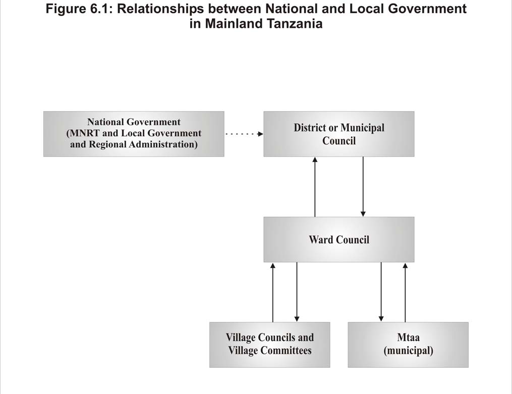
6.4.1.1
Existing Conditions
The approach to governance in the URT is one of decentralisation. The national government's role is to
develop policies and regulations that are, in turn, implemented through district and village-level government
(Juma 2004). There are differences in the institutional structures and roles between the Mainland and
Zanzibar.
Mainland Tanzania
Figure 6.1 shows the typical government organisation in Mainland Tanzania. On the Mainland, the primary
central government authority responsible for the management of natural resources is the MNRT. Within the
MNRT, there are five separate departments Ł Fisheries; Forestry and Beekeeping; Wildlife; Tourism; and
Antiquities. The Fisheries Division oversees the development and management of fisheries, mariculture, and
marine parks. It serves to provide advice to district governments on planning and management issues. The
management of all mangroves and coastal forest use activities is overseen by the Division of Forestry and
Beekeeping. The departments of Tourism and Antiquities will also be potentially impacted by MACEMP, as
these sectors are affected. The national government has District Commissioner Offices, with Divisional
Secretaries, at the district level, which function to provide policy guidance regionally.
Figure 6.1
Relationships between National and Local Government in Mainland Tanzania
MACEMP
ESA
Ę Final Report Ę 24 January 2005
Page 55
In Mainland Tanzania, five administrative regions have Local Government Authorities (13 in total) that fall
within the coastal zone (Juma 2004) (Table 6.13).
Table 6.13
District-level Authorities Within Coastal Mainland Tanzania
Region Local
Government
Authority
Tanga
Tanga Municipal Council
Muheza District Council
Pangani District Council
Coast
Bagamoyo District Council
Mkuranga District Council
Mafia District Council
Dar es Salaam
Kinondoni Municipal Council
Temeke Municipal Council
Ilala Municipal Council
Lindi
Lindi Town Council
Kilwa District Council
Mtwara
Mtwara Town Council
Mtwara Rural District Council
The District Councils and Municipal Councils are responsible for implementation and enforcement of national
policies and legislation that address natural resource management (among others). Implementation is
operational through the District Natural Resource Offices, which have personnel dedicated to fisheries,
forestry and beekeeping, and wildlife. It is at this level that the effective implementation of national policies
and programmes is dependent on the available technical and management expertise.
Within each district or municipality, there are several wards. Within each rural area ward, there is a Ward
Council that represents a number of villages. Village-level government operates through a Village Council,
under which there are five committees to address issues at the community level. The committees include:
security; environment; community development; health; and finance and planning. The Village Council has
the direct local-level responsibility for the planning and implementation of projects, and for making decisions
regarding such matters as land allocation and community resource use. In practice, however, their activities
tend to be more narrowly focused on revenue collection and enforcement. Of particular relevance to
MACEMP are the village environment committees or other similar committees, whose responsibilities include
the management and conservation of marine resources. In urban municipalities, individual Mtaa provide
representation below the ward level (i.e., there is no Village Council or Village Committees) and have
established relationships with the municipal Ward Council.
Coastal communities are also associated through the Village Assembly, who must approve decisions made by
village governments before being sent to the ward level for subsequent review and approval (which,
subsequently must in turn be reviewed and approved at the district level). Specifically with respect to coastal
resource management, the business of the Village Assembly includes the development of resolutions
respecting desired land allocation, fishing practices, forest resource management (including silviculture and
harvesting activities), natural resource use fees, and penalties and fines.
In Mainland Tanzania, the current capacity of the Fisheries Division, the NEMC, and supporting research
institutions (i.e., TAFIRI) is limited, both in terms of staff levels and training. Approximately 50% of
Fisheries Division staff have specialised training in the fields of oceanography, marine biology or fisheries
biology, although only 15% have BSc degrees or higher (MNRT 2001). NEMC, who has the mandated
responsibility for the environmental screening of projects, has 10 professional staff nationally, and no
Environmental Officers at the district or municipal level (Juma 2004). The training of staff at the district
level, however, has been initiated. Under the new Environmental Management Act (2004), Districts
Authorities are to appoint Environment Officers. At the district level, the majority of government staff have
certificate or diploma level training (80%). A much smaller number have specialised training in some aspect
of ICM (i.e., coastal planning, PRA, reef monitoring, or mariculture).
MACEMP
ESA
Ę Final Report Ę 24 January 2005
Page 56
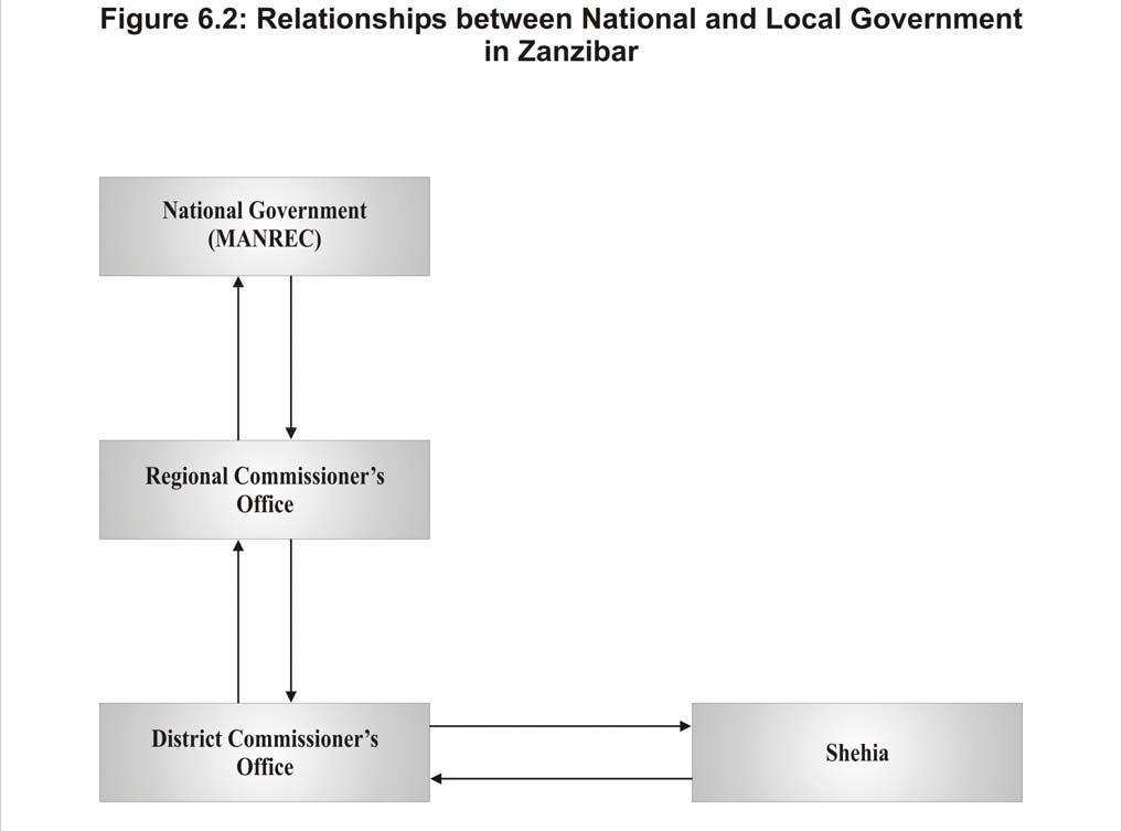
Zanzibar
Figure 6.2 shows the typical government organisation in Zanzibar. Within the URT, Zanzibar operates in
many areas as a distinct state, governed by the Revolutionary Council and House of Representatives.
Federally, management of natural resources falls primarily under the jurisdiction of MANREC. There are a
number of separate departments within MANREC, including: the Department of Fisheries and Marine
Products; the Department of Commercial Crops, Fruits and Forests; the Department of the Environment; the
Department of Livestock; the Department of Irrigation; the Department of Co-operatives; and the Commission
for Research and Extension.
Figure 6.2
Relationships between National and Local Government in Zanzibar
On Zanzibar, there are five administrative regions, each divided into two districts (Juma 2004) (Table 6.14).
Each region is led by a Regional Commissioner, and a Regional Agricultural Development Officer deals with
natural resource management issues. The Regional Commissioner is also assisted by a Regional
Administrative Officer and Regional Development Committee, the latter to co-ordinate all development
activities within their respective areas. This structure is paralleled at the district level. In addition, however,
there are subject-matter specialists for forestry, fisheries and the environment at the district level (Juma 2004).
Both regional and district agencies are involved in planning and the implementation of government policy, as
well as the mobilisation of communities.
MACEMP
ESA
Ę Final Report Ę 24 January 2005
Page 57
Table 6.14
Regions and Districts within Zanzibar
Regions Districts
Unguja
Urban West
Urban
West
South
Central
South
North
North A
North B
Pemba
North
Wete
Micheweni
South
Chakechake
Mkoani
Below the district level, there are Shehias, which are administrative units under the responsibility of a Sheha,
who is appointed by the Regional Commissioner. A Shehia often encompasses a number or villages. The
Sheha is the Chief Government Officer and reports directly to the District Commissioner. Each Sheha has an
advisory committee of not less than 12 members (Juma 2004). In addition, committees at the local level may
be established to address specific issues (e.g., for managing the use of natural resources), but the number and
specific function of committees varies considerably across Zanzibar.
As in Mainland Tanzania, the current capacity of the Department of Commercial Crops, Fruits and Forestry
(DCCFF), the Department of Fisheries and Marine Products (DFMP), and the Department of Environment is
limited, both in terms of staff levels and training. A substantial proportion of staff (40-50%) do have at least
certificate or diploma level education (Juma 2004). This includes training in fisheries management and other
fields of natural resources management (such as forestry, marine environmental management, and wildlife
management). Those trained in ICZM, EIA and PRA are also on staff; however, training for these related,
more specialised skills has been complete by only 10-15% of the staff, with Pemba notably having much
fewer trained personnel than Unguja (Juma 2004).
In addition to the union government institutions that are responsible for non-union issues, union agencies may
be impacted by MACEMP. Of specific concern is the Ministry of Foreign Affairs. As a union agency, it has
the authority to control and regulate scientific research within the EEZ, as well as the development of
regulations with respect to the conservation of the marine environment.
Specific concerns related to national and local government relevant to MACEMP include: general lack of
staffing and funding capacity to effectively carry-out existing mandates for natural resource management,
particularly at the local government level (districts, wards, and village); overlapping jurisdiction of agencies
with respect to management of activities in the marine environment and coastal zone (see Section 2 regarding
policy and legislation framework); and lack of technical capacity in key programme areas of MACEMP,
including the need for special knowledge in mariculture, stock assessment, social research, and environmental
and natural resource economics (e.g., need for mariculturalists to provide expertise for appropriate siting and
design of developments).
6.4.1.2
Effects Assessment
Analysis of the potential positive and negative impacts of MACEMP on national and local government is
provided in Table 6.15.
MACEMP
ESA
Ę Final Report Ę 24 January 2005
Page 58
Table 6.15
Assessment of Impacts on National and Local Government
Potential Impacts
Ę Potential positive impacts associated with sub-components of MACEMP, including: Planning Common Governance Regime for
EEZ; Implementation of EEZ Common Governance Regime; Developing and Supporting Partnerships in EEZ Management;
Integrated Coastal Management Planning Support; and Developing and Supporting Partnerships in ICM.
Ę Potential negative impacts associated with support for existing and emerging MPAs, CMAs and MMAs; for management of
mangrove ecosystems; and for rehabilitation of cultural heritage sites including work overload on key implementing agencies
(e.g., MNRT and MANREC).
Significance Evaluation
Criteria Description
of
Impact
Intensity of Impact
Moderate
Geographic Extent of Impact
National, district, ward and village government offices for all
administrative jurisdictions involved in MACEMP
implementation
Duration of Impact
Short-term (negative impacts) and long-term (positive impacts)
Frequency of Occurrence
Ongoing
Reversibility of Impact
Reversible
Thresholds Unknown
Equity
Enhanced (positive impacts) and reduced (negative impacts)
Opportunities and Constraints
Enhanced (positive impacts) and reduced (negative impacts)
Significance of Unmitigated Impacts
Ę Long-term positive impacts on national and local government in coastal jurisdictions associated with capacity building activities
for: planning common governance regime for EEZ; implementation of EEZ common governance regime; developing and
supporting partnerships in EEZ management; integrated coastal management planning support; and developing and supporting
partnerships in ICM.
Ę If above identified positive impacts are not adequate in building capacity, short-term negative impacts due to immediate work
requirements imposed on government for: existing and emerging MPAs, CMAs and MMAs; management of mangrove
ecosystems; and rehabilitation of cultural heritage sites.
Likelihood
Ę Identified positive impacts highly likely.
Ę Identified negative impacts likely if staffing adjustments no made during the planning stage.
Uncertainties, Information Gaps and Data Quality
Ę Some information available at the national and district level regarding numbers of government staff, education and training (see
Juma 2004), but detailed information of capabilities, particularly at the district level and below, is generally lacking.
Mitigation/ Enhancement of Positive Effects
Ę Capacity building efforts are included as part of MACEMP activities. Some training needs may be met through existing
programmes at the Institute of Marine Sciences in Zanzibar, and the Faculty of Aquatic Sciences and Technology at USDM
(more detailed assessment of staff and programme capacities required).
Ę Thorough assessment of local government training needs. Training of District Environmental Officers in EIA process and
screening procedures will be required.
Ę Diffusion of work burden through use of opportunistic implementation arrangements (e.g., implementation of Component 3
activities through TASAF) and implementation of other donor-funded coastal and marine management programmes through
MACEMP to realise administrative efficiencies.
Ę Assess applicability and review consistency of activities with Village Land Use Plans, Village By-laws and other local-level
natural resource management planning Ł compliance with existing plans and by-laws (rather than "re-inventing the wheel") will
reduce work requirements on government.
Monitoring and Evaluation
The following indicators should be measured and monitored:
Ę Number of local government staff trained in EIA process and screening, and other required specialisations.
Ę Time required for decisions to be rendered regarding MACEMP funding proposals.
Residual Negative Impacts: Not Significant
6.4.2
NGOs, CBOs and the Private Sector
NGOs are organisations funded through private sources and are independent of national and local government
agencies. They tend to be organisations with a primary cultural or social development agenda. They can
include academic institutions, private voluntary organisations (international development aid agencies), and
co-operative development organisations. CBOs are private non-profit organisations that work in a community
to improve some aspect of the community normally dealing with interventions at the community level and
generally working on social issues. The private sector includes enterprises using private investments for
profit, and is not taken to include a specific marine resource use sector (e.g., fisheries), but is meant to be
inclusive of business activities and the investment climate as a whole.
MACEMP
ESA
Ę Final Report Ę 24 January 2005
Page 59
6.4.2.1
Existing Conditions
NGOs and CBOs
Table 6.16 provides a list of NGOs working in the natural resource sector in coastal areas of the URT.
Involvement in marine and coastal management is largely project and area-specific. There are a small number
of network organizations (e.g., the Southern Zone Confederation for Conservation of the Marine Environment
Ł Shirikisho Ł network in Mtwara and Lindi regions formed under the auspices of the Rural Integrated
Programme Support) (Juma 2004). There is also a network of forest conservation groups dealing with Joint
Forest Management. Size and organisational complexity ranges, from smaller local groups, to large
international NGOs (e.g., World Wide Fund for Nature, WWF; International Union for the Conservation of
Nature, IUCN).
Main areas of focus include:
Ę
Conservation of biodiversity Ł management of MPAs, establishing systems of community-based marine
resource management (involving local user groups in both management and benefit regimes), restoration
of habitats, promotion of sustainable use, and conservation of species of concern (e.g., dugongs, turtles);
Ę
Community well-being Ł promotion of alternative livelihoods, and empowerment of disadvantaged and
vulnerable groups;
Ę
Lobbying and advocacy for policy, legal and institutional reforms;
Ę
Capacity building Ł technical support to community-based projects, assistance to communities in
interpretation of government laws and regulations, developing resource management plans, and
specialized training, education and awareness raising; and
Ę
Monitoring, and research and development.
Traditionally, NGOs formulate and implement projects parallel to the government efforts. Organisations that
are well-connected and better resourced have their own extension staff and reporting systems, with no or little
involvement of the government. Of late, NGOs are striving to integrate within local government
administration, operating through the District Councils and Village Committees in development and
conservation programmes.
At community level, NGOs render technical support to community-based projects and are also familiar with
community problems and needs, and are generally accepted by communities. They also assist communities in
interpreting laws and regulations, assist in organising communities, and providing services for education and
training. Together with government donor-supported programmes, NGOs have been responsible for formation
of community groups through which they operate. This is either within or outside the government
administrative structure, depending on the area.
Most of the local NGO and CBOs were initiated by donor-supported programmes and are vulnerable to
changes in external factors such as financing and technical support on which their long-term persistence
depends. They are generally characterised as having relatively few staff to offer extension services, with one
individual per field of specialization. Higher staffing ratios are found within international NGOs. To
overcome the problem and help build a sense of local ownership in the project, most NGOs now make use of
District Council staff.
The Private Sector
There is a general lack of development of the private sector in coastal communities due to lack of market
access, lack of supporting infrastructure at the village level, and poor transportation networks, among others.
Access to credit for the development of small businesses, and a lack of entrepreneurship skills among rural
residents, is also an issue.
MACEMP
ESA
Ę Final Report Ę 24 January 2005
Page 60
Table 6.16
NGOs Active in the URT
NGO Charactersitics
Area
of
focus
IUCN
A union of governments, government agencies, and non-
Advises and assists governments, organizations and local communities in devising conservation
governmental organisations, scientists and experts working at the
strategies and implementation and protect the coral reef of Tanzania. Current initiatives:
field and policy levels to protect nature.
Ę Mnazi Bay Ł Ruvuma Estuary Marine Park, Tanzania. Working in collaboration with Marine
Park and Reserve Unit to establish and prepare a strategy for the park.
Ę Collaborative Fisheries Management Areas in Tanga. A community-based fisheries
management approach of multiple use reserves, known as Collaborative Management Areas
(CMAs). Six CMAs in operation, covering 1,604km2 each with its own management plan.
Villageshave voluntarily closed certain reefs to allow fish stock replenishment and
reefrecovery.
Ę Rufiji Environmental Management Plan (REMP). Biodiversity assessment and builds capacity
for preparation and implementation of environmental management plans at both districts and
village level.
Ę Tanga Coastal Zone Conservation and Development Project (TCZCDP). Build capacity with
integrated coastal management at community based fisheries resources and coastal forestry
including coastal management, gender and governance
Ę Pangani Integrated River Basin Management. Promotes dialogue among stakeholders and the
resource users. Assessment of environmental flows. Analyse environmental economics of the
water resources related in the basin.
WWF
Independent conservation organisation and a global network of
Supports current MPAs across the region and has positively influenced the designation of new
national organizations, associates, and programme offices. Science- MPAs. Of particular note is support to Mafia Island Marine Park., the Mafia-Rufiji-Kilwa
based, solution-oriented conservation projects and policy work with Seascape Project, and projects on lowland coastal forests (Zaraninge forest and Matumbi forest).
capacity building and environmental education.
CARE Tanzania
An international organization that works for humanitarian relief and CARE now works in 13 districts in Tanzania, strengthening civil society, basic and girls'
development in 66 countries. CARE initial operations in Tanzania
education, nutrition and food distribution, health, HIV/AIDS, integrated conservation and
1994 to 1996 focused on refugees. Now manage a large
development, education, and agricultural development. In the coastal area, CARE manages
development programme in several areas.
projects for the Jozani-Chwaka Bay Conservation Area and Misali Island Conservation Area.
Chumbe Island Coral Private company created for the management of Chumbe Island.
Chumbe Island is an uninhabited island with coral rag forest and bordered, on its western shore,
Park Ltd (CHICOP)
The project is non-commercial, while operations follow commercial by a fringing coral reef of exceptional biodiversity and beauty. It was the first Marine Park in
principles.
Tanzania and only private marine park in the world. The reserve includes a reef sanctuary and
protected forest.
Shirikisho
A community initiated organization and NGO that deals with
Shirikisho development objectives, relate to media are: promote regional rural media to give
coastal management in Lindi and Mtwara districts through Rural
villagers voice; promote rural media to give villagers access to information.
Integrated Project Support (RIPS). RIPS project works with coastal
communities to reduce dynamite fishing and raise awareness about
the importance of coastal resources.
ACDI/VOCA
Working with FMC Corporation to promote environmentally sound Working with the entire seaweed industry, including local private-sector developers; other
and sustainable production and marketing of certain types of high-
integrated coastal management projects, government authorities and USAID, to promote growth
value seaweed used in pharmaceuticals and food processing.
and expansion.
Efficient delivery of technical assistance and equipment and
strengthens links between small-scale producers and profitable
markets. Implementing the Smallholder Empowerment and
Economic Growth through Agribusiness & Association
Development programme (SEEGAAD)
Global Ocean
International organisation that deals with global ocean observing
The organisation is still in its initial stages in Tanzania.
Observing System
system. Monitors key stone ecosystems including the Indian Ocean
(GOOS)
region through monitors on the ground and remote sensing
MACEMP
ESA
Ę Final Report Ę 24 January 2005
Page 61
Table 6.16
NGOs Active in the URT
NGO Charactersitics
Area
of
focus
Jumuiya Endelevu
Umbrella organisation of community based which provide
Works closely to implement ICM action plan
Bagamoyo (JEBA
economic and social support. The NGO support the seaweed
society)
farming.
ENVIRO-CARE
A community initiative organisation and NGO, which provides a
Reduction of the incidence of contagious diseases in the Mwembetanga district of Zanzibar (an
specialist, rapid-response monitoring service environmentally.
island off the coast of Tanzania) has inadequate sewerage and sanitation systems
Tanzania Association
Works closely with TCMP to implement ICM plans. The
Group formation, participatory planning and management of the group activities, lobbying and
of Women Leaders in beekeeping and processing of bee products project by the Kisiju
negotiation skills, conflict resolution and record keeping of the group undertakings. Leadership
Agriculture and the
Pwani. Responsible for implementation and management of the
skills
Environment
project.
(TAWLAE)
The Academy for
An independent, non-profit international organization dedicated to
Working with a large number of government agencies, local and international NGOs and local
Educational
promoting human development through education, communication, communities. Produce a video "Voices from the Coast", Develop a pilot national television
Development (AED)
and information
programme, With local district officials, organize successful Coastal Environmental Awards
Schemes.
Marine Action
A local non-governmental promotes environmental marine
Supports marine environment protection projects, fosters interaction between Tanzanian scientists
Conservation
conservation, and protection in Tanzania.
and foreign institutions and individuals. Restoration of coral reef ecosystems by transplanting
Tanzania (MACT)
corals in dynamited sites at Kunduchi Fishing Village. Supports local community with eco-
tourism in the Dar es Salaam Marine Reserve System.
Western Indian Ocean A non-governmental and non-profit regional organization,
Participating in the building of marine science and technological capability of the WIO region by
Marine Science
promoting the educational, scientific and technological development focusing communication among the scientific community of WIO and institutional linkages
Association
of all aspects of marine sciences throughout the Western Indian
within the region
(WIOMSA)
Ocean (WIO) region.
Jozani Environmental A local umbrella group of villages formed to help CARE and
Conservation education and forest protection. Establish village forests reserves adjacent to the
Conservation
Zanzibar's government manage resources. Represents villagers in
proposed National Park (The Jozani-Chwaka Bay Conservation Area).
Association (JECA)
close proximity. Chwaka Bay supports the largest block of
mangrove forest on Zanzibar, internationally important wintering
population of the crab plover.
Misali Island
Implementing a community based natural resources management
Management plans.
Conservation
project, supported by CARE Tanzania.
Association (MICA)
MACEMP
ESA
Ę Final Report Ę 24 January 2005
Page 62
There is relatively little involvement of the commercial private sector in rural coastal villages, particularly as
it is associated with use of coastal and marine areas. Commercial fishing activities are addressed under
Section 6.3.1 (Fisheries).
6.4.2.2
Effects Assessment
Analysis of the potential positive and negative impacts of MACEMP on NGOs, CBOs and the private sector
is provided in Table 6.17.
Table 6.17
Assessment of Impacts on NGOs, CBOs and the Private Sector
Potential Impacts
Ę Potential positive impacts associated with boundary delineation as part of implementation of EEZ common governance regime,
support of international and regional dialogue on boundaries and governance, and support of private sector dialogue as these
activities can be expected to increase certainty in planning for management and operations (affecting NGOs, CBOs and the
private sector).
Ę Potential positive impacts associated with ICM planning support, development of a national plan for MPAs, general MPA
management training, and the development and support of partnerships in ICM (regional, community and private sector
partnerships) as these activities will support and supplement the current efforts of NGOs and CBOs.
Ę Potential negative impacts associated with support for existing and emerging MPAs, CMAs and MMAs, for management of
mangrove ecosystems, and for rehabilitation of cultural heritage sites if NGO and CBO capacity not adequate. There may be
delivery constraints due to the unavailability of qualified staff.
Significance Evaluation
Criteria Description
of
Impact
Intensity of Impact
Moderate
Geographic Extent of Impact
Country and community-level offices of NGOs for all involved
in MACEMP implementation; district and centrally-located
private sector operations
Duration of Impact
Short-term (negative impacts) and long-term (positive impacts)
Frequency of Occurrence
Ongoing
Reversibility of Impact
Reversible
Thresholds Unknown
Equity
Enhanced (positive impacts) and reduced (negative impacts)
Opportunities and Constraints
Enhanced (positive impacts) and reduced (negative impacts)
Significance of Unmitigated Impacts
Ę Long-term positive impacts on NGOs, CBOs and the private sector for those operating in coastal jurisdictions associated with
boundary delineation as part of implementation of EEZ common governance regime, support of international and regional
dialogue on boundaries and governance, and support of private sector dialogue.
Ę Long-term positive impacts on NGOs and CBOs in coastal jurisdictions associated with ICM planning support, development of a
national plan for MPAs, general MPA management training, and the development and support of partnerships in ICM.
Ę If MACEMP activities are not adequate in building capacity, short-term negative impacts due to immediate work requirements
imposed on NGOs and CBOs for: existing and emerging MPAs, CMAs and MMAs; management of mangrove ecosystems; and
rehabilitation of cultural heritage sites. However, NGOs and CBOs unlikely to take on new work tasks associated with
MACEMP unless they believe resourcing and capacities are adequate.
Likelihood
Ę Identified positive impacts highly likely.
Ę Identified negative impacts likely.
Uncertainties, Information Gaps and Data Quality
Ę Some information available at the national and district level regarding the capacity of NGOs and CBOs operating in the coastal
areas of the URT (see Juma 2004), but detailed information is generally lacking.
Ę Little information available regarding the operations of the private sector, particularly in rural coastal areas.
Mitigation/ Enhancement of Positive Effects
Ę Diffusion of work burden through use of opportunistic implementation arrangements (e.g., implementation of Component 3
activities through TASAF) and implementation of other donor-funded coastal and marine management programmes through
MACEMP to realise operational efficiencies.
Ę NGOs, CBOs and the private sector will respond to opportunities.
Monitoring and Evaluation
Ę Number of MACEMP sub-projects of activities with private sector investment.
Residual Negative Impacts: Not Significant
MACEMP
ESA
Ę Final Report Ę 24 January 2005
Page 63
6.5
Cumulative Effects
Development programmes that have the potential to interact with the Project and result in cumulative effects
include:
Ę
The Tanzania Social Action Fund (TASAF II);
Ę
Japan Social Development Fund (JSDP) activities;
Ę
The Local Government Support Programme (LGSP);
Ę
The Participatory Agricultural Development and Empowerment Project (PADEP);
Ę
European Union Programmes;
Ę
Restoration of Cultural Heritage Sites in Mainland Tanzania and Zanzibar;
Ę
The South West Indian Ocean Fisheries Project;
Ę
The Targeted Research Project on Coral Reef Management;
Ę
The Tanzania Coastal Management Partnership (TCMP); and
Ę
The National Strategy for Growth and Reduction of Poverty.
Each of the above programmes consists of numerous sub-project activities and it is beyond the scope of this
study to examine the cumulative effects associated with the interactions between these individual sub-projects
and MACEMP. Any negative sub-project-specific impacts are best mitigated and positive impacts enhanced
through identified MACEMP implementation processes, practices and procedures.
In addition to the development programmes discussed here, there are other site-specific coastal zone
management initiatives in coastal areas of the URT. For example, the WWF Tanzania Programme Office, in
partnership with the Vice-Presidents Office, NEMC, the TCMP and the District Authorities of Rufiji, Mafia
and Kilwa, has begun the 5-year (2004-2009) Rufiji-Mafia-Kilwa Seascape Project to develop and implement
a marine and coastal resource management programme (Juma 2004). The primary components include: 1)
collaborative engagement; 2) village planning; 3) improved livelihood support; 4) habitat and species
protection; and 5) data and information for management. There are also other smaller projects funded by
Ireland (Tanga ICM), Norway (mangrove management) and Finland (artisanal fisheries project). It will be
important for MACEMP to effectively link with these projects where area-based activities overlap.
All such donor activities should, in fact, be co-ordinated through MACEMP, as the larger, coast-wide
programme. Co-ordination and information sharing with other donors, many of which have ongoing
programmes in marine and coastal areas, will, in part, take place through the Development Partner Group on
Environment, an informal information sharing mechanism. However, to compliment this, a more formal
mechanism needs to be developed with the government in a lead role. It is expected that the MACEMP will
also set up a web-site which will contain project-related information, progress on indicators and news from
target sites.
6.5.1
TASAF II
The objective of the TASAF is to empower communities to manage interventions that contribute to improving
their livelihoods, by supporting community sub-projects targeted at improving service access to health,
education, water and sanitation, banking and markets; transferring cash through labour-intensive public
works; and supporting income generation for households with vulnerable individuals. TASAF targets three
groups: 1) service poor communities, where investments close the existing gaps in social services delivery; 2)
food insecure communities, where investments lead to cash transfer to able-bodied poor through the creation
of economically viable community assets; and 3) vulnerable persons and disadvantaged groups, where
investments support income generating activities by care givers.
MACEMP
ESA
Ę Final Report Ę 24 January 2005
Page 64
The implementation of MACEMP sub-projects associated with Component 3 (Coastal Community Action
Fund) will occur through TASAF. The necessary MACEMP funds would be "ring-fenced" for placement in
dedicated accounts and subsequent allocation at the district level. The working relationship between TASAF
and MACEMP should be specified in their respective legal agreements.
It is expected that the following interventions will be implemented as a part of the MACEMP community
package:
Ę
Advocacy, Information and Mobilization. This will include community-driven initiatives aimed at
informing people about natural resource management and the need and benefits from improved practices.
A coastal resources management package to inform the communities will be prepared based on needs
assessment. Communities and households will be mobilised and sensitised to facilitate formation of
resource user groups to formulate sustainable livelihood options.
Ę
Capacity Enhancement. This will include support for initiatives to provide skills needed to design,
implement and effectively manage projects at community level. Activities will facilitate participatory
community involvement and selection of priorities, as well as training in managerial, budgeting, and
financial accountability for the procurement of goods and materials. It will also focus on strengthening the
capacity of communities to establish linkages with other organizations, particularly CBOs and NGOs
interested in supporting collaborative management activities. Activities to strengthen and provide
technical support to District Environmental Officers who would be involved in the appraisal of sub-
project proposals are also envisioned. These would be further supported by the development and
awareness creation of environmental impact assessment guidelines to evaluate proposed community
activities.
Ę
Improvement of Quality and Increased Sustainable Utilization of Coastal Resources. This package will
support community-driven initiatives to improve coastal community livelihoods. The initiatives may
include the demand of technical, physical, or social services to support potential community sub-projects,
including alternative income generating activities (AIGAs), such as: fishery-based (fishery aggregation
devices to increase fish catch, fish processing, sustainable aquarium-fish collection, fish cage aquaculture,
small-scale fish landing site infrastructure, medium-scale fish infrastructure such as small docks, and
complementary fish processing devices such as ice plants and refrigeration units); coastal-based non-
fishery (pearl or shellfish culture in shallow water, seaweed/algae farming, value added industry
associated with pearl or shellfish culture, value added industry associated with algae farming); coastal-
based non-traditional fishery (brackish water agriculture, sustainable mangrove production, mangrove
honey and wax production, fish fry nursery); other coastal (complementary industries, joint food product
value added, eco-tourism ventures).
The TASAF approach is to create partnerships between communities and local government authorities
(LGAs). A National Village Fund is established to finance sub-projects, which are identified through a
community-level demand-driven process. The National Village Fund, in turn, feeds Village Level Funds,
managed by the respective Village Council, Shehia Advisory Council, or Mtaa Committee. The management
of individual sub-projects are the immediate responsibility of elected Community Management Committees,
which report to the Village Council, Shehia Advisory Council, or Mtaa Committee. In addition, Local Service
Providers directly implement sub-projects, and are procured by individual Community Management
Committees. The primary function of the Local Service Provider is the supervision of sub-project
implementation according to a developed community sub-project handbook. These activities will require:
provision of technical supervision to ensure compliance to local government regulations, norms and standards;
assistance to the Community Management Committee in project planning; and job training of beneficiaries to
ensure the necessary technical skills.
MACEMP
ESA
Ę Final Report Ę 24 January 2005
Page 65
A Coastal Village Co-ordinator is to be appointed and assigned to each village (an individual co-ordinator
may have responsibility for a number of villages). The Coastal Village Co-ordinator will be responsible for:
assisting with the mobilisation of communities and households, and facilitating the formulation of resource
user groups; facilitating the identification and formulation of sustainable livelihood options (sub-projects);
assisting communities with the process of applying for funding of community-driven initiatives; and
facilitating access of support to communities with respect to sub-project design and the establishment of
potentially beneficial linkages with other organisations (i.e., NGOs and CBOs). It is important that the co-
ordinator be respected and have some authority within the community served. This person should also have
specific knowledge and understanding of the social and environmental issues faced by the villages served, and
have experience in developing proposals and group communication and facilitation. This person should not be
a district of national government official, but may be involved in village-level government or a local NGO or
CBO.
It will also be necessary for selected sub-projects to be consistent with regional and local government policies,
regulations and bylaws on the construction of facilities, such as fisheries landing sites. This should be built
into the selection criteria to inform decisions on funding sub-projects. The screening tool should principally
cover the marine and coastal environmental management issues associated with potential MACEMP sub-
projects. It will be necessary for MACEMP to build capacity at the district level (e.g., District Environmental
Officer), as local government staff would be involved in the appraisal of the MACEMP/TASAF sub-project
proposals. Training would focus on elements of MACEMP sub-projects that would be distinct from those of
sub-projects that would typically be experienced through TASAF.
6.5.2
JSDF Activities
A Japan Social Development Fund (JSDF) of US$1.8 million has been approved for the Tanzania
Community-based Coastal Resources Management and Sustainable Livelihood Project. The objectives of the
project are to overcome the problems of poverty and resource degradation in the coastal areas through
enhancing the livelihoods of poor and vulnerable groups in the coastal communities. Implementation of the
JSDF began mid 2004, and the project is scheduled for completion in 2006.
Communities in the coastal area of Menai Bay, Mnemba Island, and Misali Island (Zanzibar), and in Kilwa
District, Rufiji District, and Mafia Island (Mainland Tanzania) will participate in the activities supported by
the project. Specific activities include:
Ę
Raising environmental awareness in local communities, through: a) demonstrations of best practices in the
management of coastal resources, and identification of profitable activities; b) provision of training to
villagers in coastal resource planning, coastal and fisheries management policies, livelihood skills,
environmental monitoring, reporting and regulation; and c) establishment of a pilot coast-watch network,
through technical advisory services, training and purchase of communication tools and small boats for
patrol activities.
Ę
Preparation and implementation of Collaborative Fisheries Management Plans with the participation of
locally recruited fisheries planning teams, village natural resource committees, village environmental
committees and CBOs.
Ę
Testing of innovative approaches for social development, including: a) improving the business
environment through the establishment of a forum to facilitate dialogue among communities, the private
sector, and government; and b) providing business development opportunities through provision of
technical advisory services and goods to support income generation activities for seaweed enterprises,
fisheries, coast-watch network, shellfish and mud crab farming, and aquaculture production.
The implementation of these activities will be through contracted NGOs. The Tanzania Community-based
Coastal Resources Management and Sustainable Livelihood Project will follow MACEMP procedures, in
MACEMP
ESA
Ę Final Report Ę 24 January 2005
Page 66
which the MACEMP PMUs will be responsible for contracting the implementing NGOs. The JSDF-funded
project will be use separate criteria for determining eligibility for funding, but will rely on MACEMP
mechanisms for programme delivery.
6.5.3
Local Government Support Programme (LGSP)
The LGSP consists of three components:
Ę
Local Government Grants. Investments are in accordance with local needs as determined through
participatory planning and budgetary processes. Investments focus on capital purchases associated with
small-scale sub-projects that may include, for example, water development, the rehabilitation or
expansion of existing education infrastructure, sanitation systems, roads, bridges, and health
infrastructure.
Ę
Dar es Salaam Upgrading and Institutional Strengthening. As part of this component, the Community
Infrastructure Upgrading Programme is targeted at unplanned and under-serviced residential areas in Dar
es Salaam. The Operations and Management/Revenue Enhancement Programme will improve local
expenditure and local revenue collections to support such expenditure.
Ę
Management and Institutional Development. This component supports the President's Office Ł Regional
Administration and Local Government (PO-RALG) in the implementation, monitoring, evaluation and
audits of the Project and the transfer programme supported by local government grants.
There are no linkages between or overlaps in the activities of LGSP and those of MACEMP evident. There is
the potential for the LGSP and MACEMP to compete for local government resources given that both rely on
local governments for programme delivery. However, both projects include explicit capacity-building
components to address these concerns.
6.5.4
PADEP
The Participatory Agricultural Development and Empowerment Project (PADEP) operates separately in
Zanzibar and the Mainland. The overall objective is to increase agricultural productivity and production and to
improve farm income and food security in order to reduce poverty. In Zanzibar, the specific objectives are: a)
empowering the farming communities to engage in profitable farming activities; b) strengthen institutional
capacities and co-ordination to identify, plan, implement, monitor and evaluate agricultural activities; c)
enhancing increased agricultural productivity and production through the use of better land management
practices and crop livestock intensification; and d) enhancing private sector participation in marketing of
agricultural inputs and outputs and provision of essential support services.
In the Mainland, the specific objectives are: a) empowering self-selected rural communities and farmer's
groups to make decisions regarding choice of sustainable and renumerative productive technologies; b)
sharing of costs by the public sector and participants; c) enhancing demand for products and services provided
by the private sector in rural areas by increasing the purchasing power of participating groups and
encouraging the growth of savings; d) promoting improved land and crop husbandry practices; e) supporting
the ongoing decentralisation process at the district level; and f) partially financing maintenance and/or
construction of roads, bridges, and other small sub-projects to improve access to markets.
In practice, PADEP activities have focused on agricultural development away from the coastal zone. There are
no explicit linkages between or overlaps in the activities of PADEP and those of MACEMP evident. Activities
need not be co-ordinated. It is possible that coastal communities will be in a position to receive support from
both programmes, particularly in Zanzibar.
MACEMP
ESA
Ę Final Report Ę 24 January 2005
Page 67
6.5.5
European Union Programmes
The European Commission Regional Programme for Sustainable Management of Coastal Zones focuses on
the countries of the southwest Indian Ocean. Funding of the URT component may occur through MACEMP,
pending the results of further discussions.
Under this programme, the European Commission is currently providing funds for two relevant projects
(World Bank 2004): the SADC Monitoring, Control and Surveillance (MCS) Project,2 which is working to
establish enforcement capabilities for patrolling in the EEZ (including marine waters of the URT); and the
Sanitary Control Project,3 which is working to increase the access of fish products from developing countries
to the EU, and raise hygiene standards and income opportunities for small-scale fisheries. In addition, the
Tuna Tagging Project for the Southwest Indian Ocean is expected to begin by the end of 2004.
The MCS Project, in particular, has a number of roles and tasks that both compliment and overlap with
MACEMP activities (Juma 2004). More specifically, the MCS Project involves:
Ę
Providing air and sea surveillance of the EEZ;
Ę
Obtaining necessary air and sea patrol assets;
Ę
Supporting the monitoring of municipal and local fishery markets;
Ę
Aiding district offices and community fishery committees in the pursuit of prosecution; and
Ę
Training fisheries staff and related enforcement agencies.
The EU is currently negotiating a renewed fisheries agreement with the URT that will define the conditions
under which EU-based vessels will fish within the EEZ. This agreement will likely include provisions
regarding management responsibilities for the fishery to be assumed by the EU, as well as accompanying
social development grants to the URT.
The allocation of social development grants may be done through a possible parallel financing arrangement
with MACEMP. Appropriately targeted areas for development assistance may be an effective way to mitigate
potential negative impacts of the MACEMP.
6.5.6
Restoration of Cultural Heritage Sites
The restoration of cultural heritage sites in Mainland Tanzania is lead by the Department of Antiquities
(MNRT). The focus in the Kilwa District, with the internationally recognised site in Kilwa Masoko, is on: 1)
conserving monuments and ensuring that they are well-managed to prevent deterioration at the site; and 2)
promotion of the site through the provision of information to tourists and research activities. Current funding
commitments from the Government of Japan and the Government of France cease at the end of 2005. The
Antiquities Department is looking for ways to extend the current programmes to realise the full longer-term
benefits of activities. Further developments hope to more completely integrate restoration plans with tourism
development, and transportation and service infrastructure. Engagement and involvement of local
communities early in the planning process, and the development of linkages to local livelihood benefits, is
recognised as key to effective implementation.
Other priority sites for restoration activities include Bagamoyo (contract drafted with Sweden to carry out
activities similar to Kilwa Masoko) and Mafia (donor yet to be identified). There are preliminary plans for
other sites in the conceptual development stage. The WB and representatives of the Embassy of France have
2 See http://www.mcs-sadc.org/
3 See http://www.sfpacp.org/
MACEMP
ESA
Ę Final Report Ę 24 January 2005
Page 68
had informal discussions on the synergy between MACEMP and the French and Japanese support for cultural
property rehabilitation in the Kilwa area. The collaboration will need to be formalized with more consultation
with the Department of Antiquities and key implementation entities. It is expected that parallel financing and
potential for co-financing will be determined during appraisal and such possibilities will need to be
communicated to the WB by the URT. The co-ordination of efforts is an important potential way in which
greater development assistance efficiencies can be achieved. This work should be compliant with WB
Safeguards on Cultural Property (OP 11.03).
In Zanzibar, other than the phased-out project of restoration of areas of Stone Town, there are no other
initiatives related to the restoration of cultural heritage sites. MACEMP is to initiate the process of
rehabilitation of sites in Zanzibar to compliment activities in Mainland Tanzania.
6.5.7
The South West Indian Ocean Fisheries Project
The South West Indian Ocean Fisheries Project (SWIOFP) is one of three inter-linked projects in the
international waters focal area being prepared by the World Bank and the UNDP in response to country
requests for assistance in better managing the living resources and habitat of their shared marine ecosystems.
The SWIOFP consists of five major components:
Ę
Collection of data describing the various fish species (and particularly those under environmental or
human-related threat) in the 200 nm EEZ of the Project countries;
Ę
A fish pressure survey to estimate the commercial fishing pressure within the study area, from which
countries the pressure comes, the capture methods used, and the location of the pressure on a seasonal
basis;
Ę
Establishing a project management structure, with associated links between government managers of the
offshore resource along the East and Southeastern coast of Africa that would build capacity, provide a
forum to exchange essential information, and foster collaboration toward decision making that would
facilitate creation of a Southwest Indian Ocean Fisheries Commission, should such be warranted based on
the outcome of the proposed project; this would also undertake the coordination or linkage function with
the other two projects;
Ę
Formulation of intermediate management guidelines, protected areas and seasons to reduce threats to
endangered fish species and to control exploitation of fish stocks to environmentally sustainable levels
and to ensure linkages with artisanal fishers' needs and those of coastal biodiversity; and
Ę
The adoption by the end-of-project of a fisheries management strategy including appropriate institutions
at a national and regional level for implementation of this ecosystem approach to Large Marine
Ecosystems (LMEs) and their fishery resources.
There is an agreement between SWIOFP and MACEMP that all monitoring and stock assessment activities
within URT marine waters over the continental shelf and shelf-break areas, to a depth of 500 m, will be the
responsibility of MACEMP. All activities beyond this distance will be the responsibility of SWIOFP.
6.5.8
The Targeted Research Project on Coral Reef Management
The overall objective of the GEF-funded Targeted Research Project on Coral Reef Management is to align the
expertise and resources of the coral reef community around key research questions related to the resilience
and vulnerability of coral reef ecosystems, to integrate the results, and to disseminate them in formats readily
accessible to managers and decision-makers. A related objective is to build much-needed capacity for science-
based management of coral reefs in developing countries, where the majority of reefs are found. It is a
research-based project, focusing primarily on the monitoring of reef conditions.
MACEMP
ESA
Ę Final Report Ę 24 January 2005
Page 69
There are no explicit linkages between or overlaps in the activities of the Targeted Research Project on Coral
Reef Management and those of MACEMP evident.
6.5.9
The Tanzania Coastal Management Partnership
The Tanzania Coastal Management Partnership (TCMP) is an initiative established in 1997 within the Vice
President's Office, with support from USAID, to improve national coastal planning, policy and management,
and to co-ordinate local and national coastal resource management. The main implementing partners are the
University of Rhode Island and the NEMC. For the phase ending September 2003, TCMP:
Ę
Developed and supported adoption of a National Integrated Coastal Environmental Management Strategy
(2003);
Ę
Supported intersectional working groups addressing major economic opportunities along the coast (e.g.,
mariculture, tourism) to develop investment guidelines (Coastal Activity Guidelines) that includes
definition of "major economic development" under EIA guidelines, siting requirements, permit
procedures, good operational practices, and monitoring protocols;
Ę
Supported development of Local ICM Action Plan Guidelines, which were adopted in the districts of
Pangani, Bagamoyo and Mkuranga;
Ę
Supported development of a Guideline for Special Area Management Plans (SAMPs) for specific
geographical areas of concern;
Ę
Supported formation of the Science and Technical Working Group to identify management-related
research needs;
Ę
Supported the Coastal Environmental Award Scheme (CEAS) as a vehicle for awareness raising; and
Ę
Supported capacity building through coastal ecological courses for district officers, as well as "learning-
by-doing" training for government officials at the national level.
Now in its second phase (2003-2005), the initiative's main focus is implementation of the ICM Strategy
through specific proposed mechanisms, including: mainstreaming and integrating government activities,
supporting planning at the district level, capacity building and improved communication. In the future, TCMP
may operate within NEMC as a government agency.
There are clearly some important linkages between the objective and activities of TCMP and those of
MACEMP. USAID is to provide parallel financing for MACEMP Sub-component 2 (i.e., support for ICM
planning and capacity-building), co-ordinating efforts through MACEMP. In order to avoid other potential
inconsistencies in programme delivery and to take advantage of work done to date by TCMP, it is also
recommended that existing and developing Coastal Activity Guidelines, Local ICM Action Plan Guidelines,
and Special Area Management Plans be integrated into MACEMP activities.
6.5.10
The National Strategy for Growth and Poverty Reduction
The National Strategy for Growth and Poverty Reduction (NSGRP), finalized by the Government of Tanzania
in 2000, has three themes: a) growth and reduction of income poverty; b) improvement of human capabilities
and reduction of vulnerability; and c) achieving and sustaining an environment conducive for sustainable
development. The NSGRP has made some achievements. However, the Millennium Development Goal for
sub-Saharan Africa calls for a reduction in poverty to 24% of the population in 2015 (poverty defined as
living on less than US$1 per day) with an intermediate goal of 30% established for 2005. In 2004, overall
poverty levels in the URT are approximately 30%, but rural poverty levels remain substantially higher at 50%.
Local empowerment and participation through good governance is also regarded as a critical element in
poverty reduction; these efforts are complemented by Tanzania's ongoing programmes of decentralization of
government functions, and increased reliance on private sector investment. Sound environmental management
has also been endorsed as an important element of poverty reduction efforts, falling under the second pillar of
MACEMP
ESA
Ę Final Report Ę 24 January 2005
Page 70
the NSGRP through improvement of human capabilities and reduction of vulnerability. Specifically,
initiatives have been supported to improve environmental impact assessment, strategic environmental
assessment, and analysis of poverty-environment linkages.
The next phase, NSGRP II, is under development. Specific programme emphasis may shift. However, it is
clear the MACEMP is an important intervention to reduce coastal poverty within the framework of the
NSGRP. Programme implementation modalities and programme support areas are not likely to significantly
overlap. Functionally, MACEMP and NSGRP II will be mutually exclusive yet supporting of the overall goal
of poverty reduction.
6.5.11
Summary of Cumulative Effects Assessment
Analysis of the potential cumulative effects of MACEMP in conjunction with other donor-funded
development programmes is provided in Table 6.18.
Table 6.18
Assessment of Cumulative Effects Associated with Development Programmes
Development
Programme
Description of Potential Cumulative Effects
Significance of Effects
TASAF II
Ę Implementation of MACEMP Component 3 will
Ę Without mitigation, likely negative impacts
be through TASAF II.
on the marine and coastal environment and
Ę Potential for realisation of programme delivery
on government management (i.e.,
efficiencies, yet technical capacity may not be
investments inconsistent with regional and
sufficient at the local government level to
local government policies, regulations and
effectively screen MACEMP sub-projects; may
by-laws) as District Environmental Officers
result in approval of inappropriate sub-projects.
will likely not be familiar with management
issues specific to MACEMP sub-projects.
JSDF
Ę Potential for the realisation of increase in the
Ę Positive significant impacts predicted.
efficiency of programme delivery, and greater co-
ordination between donor programmes.
LGSP
Ę None - no linkages between or overlaps in
Ę No significant effects predicted.
activities.
PADEP
Ę None - no linkages between or overlaps in
Ę No significant effects predicted.
activities.
European Union
Ę Overlap between MCS project activities and
Ę Without mitigation, likely negative impacts
Programmes
MACEMP.
due to substantial overlap in programme areas
Ę Renewed fisheries agreement between EU and
and, thus, duplications or inconsistencies in
URT, including accompanying social development
delivery.
grants.
Restoration of Cultural
Ę Potential for conflicting/inconsistent programme
Ę Negative impacts due to lack of co-ordination
Heritage Sites
delivery due to interaction with smaller donor-
with other smaller donor-funded
funded projects (e.g., potential Mafia and
programmes, but impacts localised.
Bagamoyo project).
Ę Likely positive significant impacts associated
Ę French/UNESCO programme implemented
with the France/UNESCO programme.
through MACEMP, resulting in potential mutual
benefits and further enhancement of cultural
property.
South West Indian Ocean Ę Similar activities identified for monitoring and
Ę No significant effects, with agreed spatial
Fisheries Project
stock assessment within the URT EEZ
division of programme activities.
(Component 1 of MACEMP).
Targeted Research
Ę None - no linkages between or overlaps in
Ę No significant effects predicted.
Project on Coral Reef
activities.
Management
Tanzania Coastal
Ę Overlap of programme areas Ł parallel financing
Ę Positive impacts likely with co-ordination of
Management Partnership
for MACEMP Sub-component 2 (i.e., support for
TCMP activities through MACEMP.
ICM planning and capacity-building), co-
ordinating efforts through MACEMP.
National Strategy for
Ę MACEMP is an important intervention to reduce
Ę Programme implementation mechanisms and
Growth and Reduction of
coastal poverty within the framework of the
programme support areas are not likely to
Poverty
NSGRP.
significantly overlap.
Ę Potential for duplication of efforts with respect to Ę Functionally, MACEMP and NSGRP II will
the similar goals of improved environmental
be mutually exclusive, yet supporting of the
management and reduction of income poverty in
overall goal of poverty reduction.
rural areas.
MACEMP
ESA
Ę Final Report Ę 24 January 2005
Page 71
Table 6.18
Assessment of Cumulative Effects Associated with Development Programmes
Mitigation/ Enhancement of Positive Effects
Ę Development of a screening checklist for use by TASAF for approval of MACEMP Component 3 sub-projects (see Section 7).
Ę Training of District Environment Officers in the use of EIA methodologies to facilitate appraisal of MACEMP/TASAF sub-project
proposals. Training would focus on general EIA screening skills, as well as elements of MACEMP sub-projects that would be
distinct from typical TASAF sub-projects.
Ę MACEMP to develop project phasing strategy with MCS to co-ordinate transfer of activities and/or appropriate division of specific
programme activities. The allocation of social development grants should be done through parallel financing with MACEMP.
Ę MACEMP to co-ordinate with other smaller donor-funded programmes for the restoration of cultural heritage sites.
Ę MACEMP to co-ordinate activities to TCMP-developed Coastal Activity Guidelines as they may apply to sub-projects under the
Coastal Community Fund (Component 3) and utilise the guideline where appropriate, or incorporate necessary elements in sub-
project evaluation.
Ę Activities under Component 2.1 (ICM Planning Support) to co-ordinate with development of Local ICM Action Plan Guidelines.
Ę Activities under Component 2.1 (ICM Planning Support) and Component 3 (Coastal Community Action Fund) to co-ordinate with
development of individual Special Area Management Plans.
Ę MACEMP to effectively link with all donor-supported coastal and marine management projects where area-based activities
overlap Ł all such donor activities should be co-ordinated through MACEMP.
Monitoring and Evaluation
Ę None recommended.
MACEMP
ESA
Ę Final Report Ę 24 January 2005
Page 72
7.0
EXISTING MITIGATIVE POLICIES AND LEGISLATION
Existing URT policies and legislation will serve to mitigate many of the negative impacts of the Project, as
well as enhance the positive impacts in support of the Project's objectives (see also review by Shauri 2003).
The relevant policies and legislation fall under the following categories:
Ę
Environmental management;
Ę
Coastal zone management;
Ę
Fisheries management;
Ę
Coastal forest management;
Ę
Land management; and
Ę
Cultural property and antiquities.
The pertinent feature of the policies and legislation are summarised below, with the emphasis on key
mitigations for MACEMP. Although there are numerous elements of policies and legislation that are
consistent with MACEMP activities (see Section 2.0), they are not described in detail here.
In addition to the national policies and legislation analysed here, there are several local-level policies that may
apply, but these will vary substantially by region and community. It will be important for MACEMP to review
the applicability of these once individual sites and sub-projects have been identified. Of particular relevance
are Village Land Use Plans and Village By-laws. Some Village Land Use Plans have been developed into
accessible summary documents, while for many others the existing documentation remains as participatory
appraisal records. Village By-laws define local rules (e.g., natural resources uses that are allowed, how uses
will be managed, and penalties), procedures for handling offences, and procedures for dealing with money
collected either through fines or use fees.
7.1
Environmental Management
7.1.1
Mainland Tanzania
The Environmental Management Act (2004), which has recently been promulgated, provides for the overall
management of potential negative impacts on marine and coastal ecosystems due to MACEMP project
activities, particularly those involving physical works or livelihood activity investments. The Act defines the
functions to be preformed by the NEMC, as well as Environmental Management Officers and Environmental
Management Committees that are appointed at the district, municipal, ward, mtaa and village levels. The
roles and responsibilities of the various bodies include (s.17, s.18, s.31, s.36 and s.41):
Ę
Oversee the preparation and implementation of EIA;
Ę
Facilitate public participation in decision-making;
Ę
Identify requirements for environmental audits and environmental monitoring;
Ę
Ensure compliance with national environmental quality standards, pollution control and waste
management (including various enforcement functions for violations under the Act);
Ę
Undertake programmes for public environmental education and awareness;
Ę
Prepare and implement Environmental Action Plans (EAPs); and
Ę
Provide environmental advice and technical support to other government staff at various levels.
EAPs, prepared by district and municipal governments (s.42), are to identify environmental problems
prevalent within their jurisdiction and recommend measures to mitigate the problem. Prescriptions for
environmental management may include any measure allowed under the Act. With respect to the
management of unintended impacts on the coastal zone, the Act provides for the prohibition of human
activities of a permanent nature that are likely to compromise or adversely affect conservation or the
MACEMP
ESA
Ę Final Report Ę 24 January 2005
Page 73
protection of ocean shorelines (s.57). The specific types of activities are not specified. The Minister may
formulate guidelines with respect to the conduct of such activities or, after consultation with the Minister
responsible for local government authorities and other relevant institutions, make regulations for the
promotion of ICM (s.59). Also of note are provisions for NEMC to manage areas that are deemed to be
"environmentally sensitive" (s.51). This provision is of relevance since the target areas in MACEMP include
areas that may be considered "environmentally sensitive" yet fall outside the boundaries of the marine parks.
EIAs are to be undertaken for certain activities specified in the Act (s.81). Relevant to MACEMP, this may
be applied to forest related activities, agriculture, processing industries, and any activity "out of character with
its surroundings" or as may be prescribed by regulation. More specifically, the Forest Act (2002) requires that
EIAs be completed for agricultural, aquacultural of horticultural developments on an area of land greater than
5 ha, and for the construction of buildings on land exceeding 1 ha in area (s.18). The legislated process
defines the roles of government as including prescription of the issues that must be addressed, and required
consultations and public participation (s.90). In addition to the projects listed, the Minister may require
preparation of an impact statement for any activity likely to have an impact on the environment (s.103).
7.1.2
Zanzibar
The National Environmental Policy for Zanzibar (1992) identifies the pursuit of policies that are consistent
with MACEMP activities, including ICM. The Environmental Management for Sustainable Development Act
(1996) similarly provides for the overall management of potential negative impacts on marine and coastal
ecosystems due to MACEMP project activities, and provides the basis for establishing protected areas in
marine areas (among others) and development of integrated coastal area management (see Section 6.2).
Administration of the Act is through the Department of the Environment, which is responsible for ensuring
that environmental concerns are integrated into nation development planning and project implementation;
specifying standards, norms and criteria for the protection of the environment; managing and regulating EIA
requirements; promoting public awareness of environmental issues through education programmes; co-
ordinating the monitoring of trends in the use of natural resources; preparing and co-ordinating the
implementation of environmental actions plans at the national and local levels; and co-ordinating the
preparation and implementation of community environmental management plans and integrated coastal area
management plans (s.19). The Revolutionary Council on the Environment is the final decision-maker for all
environmental matters, and approves National Environmental Action Plans (s.12).
National Environmental Action Plans identify principal environmental problems, provide a framework for
integrating environmental concerns into plans and programmes, identify strategies for preventing, controlling
or mitigating any adverse impacts on the environment, assist in identifying priorities for action, and promote
the development of a national awareness of the efficient, sustainable and equitable use of the environment
(s.32). Similarly, Local Environmental Action Plans are to be prepared where environmental problems
require special, localised planning (especially associated with coastal areas) (s.33). Any community may also
develop its own Community Environmental Management Plan (s.35).
EIA screening and approval of Environmental Impact Statements (EISs) are also the responsibility of the
Department of Environment, and EIA procedures are detailed in Regulation (2002). Activities which are
explicitly excluded from EIA, and those that specifically require and EIS are provided in the schedules to the
Act. All other activities that are "likely to have a significant impact on the environment" are to be screened.
Relevant to MACEMP, excluded activities include: domestic, private and non-commercial activities; small-
scale businesses employing fewer than 10 people; operating tours (other than dive tours); rain-fed agriculture
operations of less than 10 ha; and small-scale warehousing (Schedule 1). Activities that explicitly require an
EIS include: developing an area in a port, harbour and marina; and aquaculture operations.
MACEMP
ESA
Ę Final Report Ę 24 January 2005
Page 74
7.2
Coastal Zone and Marine Management
7.2.1
Mainland Tanzania
The National Integrated Coastal Environment Management Strategy (2003) defines strategies and
implementing mechanisms for Mainland Tanzania, particularly with respect to planning and integrated
management, conservation, research and monitoring, stakeholder participation, and capacity-building for
management. These are consistent with MACEMP activities, yet it will be important to effectively link
MACEMP implementation with initiatives completed and currently underway (see Section 5.6, TCMP).
The Marine Parks and Reserves Act (1994) provides for the establishment, management and monitoring of
marine parks and reserves. Purposes for designation include: protection, conservation and restoration of
species and genetic diversity, and ecosystem processes; stimulating the development of underutilised natural
resources; promoting the sustainability of existing resources and the recovery of areas and resources; ensuring
the involvement of villages and local residents in the planning, development and management of the marine
park and reserves, and sharing in the benefits; promoting community-oriented education and dissemination of
information; and facilitating research and monitor conditions and uses (s.10). The Act provides for the
prohibition of certain activities within parks, for the ability to regulate access to and activities within parks, for
the zoning of uses within parks, and for the designation of a buffer zone where activities may be restricted.
The Marine Parks and Reserve Unit functions to establish and monitor the control, management and
administration of marine parks and reserves, and implement and enforce the provisions of the Act (s.3).
Among other functions, it is also to provide educational and informational services to local resident users of
any marine park or reserve. The Board of Trustees for Marine Parks and Reserves formulates policies on
marine parks and related facilities, oversees the use of funds, advises on the management of marine reserves,
advises and directs on designation of specified marine and coastal areas, and the drafting and implementation
of regulations (s.4). The Advisory Committee provides advice on the management and regulations, oversees
the operation of marine parks, and consults with the Warden on technical and operational matters (s.5). The
Act includes a requirement for consultation with affected villages regarding all aspects of the development of
parks and reserves, including any amendments to regulations, zoning and general management plan, and
management and conservation issues (s.7).
If implemented as described, the Act will serve to mitigate potential negative impacts associated with
MACEMP supported activities that support emerging and developing MPAs (Component 2). In particular,
the requirement for village-level consultation is consistent with the principles outlined in the PF.
7.2.2
Zanzibar
Zanzibar does not have a separate marine parks act, per se, or a separate policy on ICM. These functions are
largely provided for with the Environment Act (1996) and the National Environmental Policy for Zanzibar
(1992). Within the Act, an area may be declared for Integrated Coastal Area Management Planning where
there are significant environmental values and intensive human activity of significant economic and social
value (s.36). The Act also provides for the establishment of a national protected areas system in Zanzibar,
where the purpose of protected areas includes preservation, sustainable utilisation by residents, education,
management of biological diversity, scientific research, and environmentally sound tourism and recreation
(s.71). Controlled areas, reserves, sanctuaries, parks and conservation areas are all types of protected area that
may be established (s.73). Rules may prescribe the activities to be permitted or restricted in areas or specific
zones. The establishment of controlled areas are also specifically addressed by the proposed Fisheries Act
(2003) of Zanzibar. A National Protected Areas Board oversees the government's policy on protected areas,
makes recommendations regarding the areas that are suitable for protection, approves management plans, and
designates the appropriate management institution (s.81).
MACEMP
ESA
Ę Final Report Ę 24 January 2005
Page 75
The Establishment of Zanzibar Nature Conservation Areas Management Unit Act (1999), promulgated as a
supplement to the Environment Act (1996), established the Zanzibar Nature Conservation Areas Management
Unit to assist with the conservation of terrestrial, aquatic or marine ecosystems through the establishment and
management of nature conservation areas (s.3). Primary functions of the unit are to: manage nature
conservation areas and act as the management authority to manage any national protected area; manage areas
for nature conservation in ways that benefit local communities and facilitate their active participation in
management; support, and where appropriate participate in, other projects to conserve the natural ecosystems
of Zanzibar, especially those projects which facilitate conservation by local communities; build the capacity
for nature conservation and management of nature conservation areas; advise, educate and promote the private
sector, local communities, government departments and other institutions on issues concerning nature
conservation; educate the public on the importance of nature conservation; and promote awareness of nature
conservation areas (s.6). The National Protected Areas Board has the responsibility of implementing the Act,
and the Chief Conservator of the Unit answers to the Board.
7.2.3
The Union
The Territorial Sea and Exclusive Economic Zone Act (1989) provides for the implementation of the Law of
the Sea Convention, and establishes the Territorial Sea (up to 12 nm) and Exclusive Economic Zone (EEZ)
(from the Territorial Sea to 200 nm) of the URT. The Act prohibits, without agreement or permit from the
URT, the exploration or exploitation of resources; the carryout of research; drilling, constructing or operation
of any structure or device; carrying out any economic activity (s.10). This explicitly does not apply to fishing
by a citizen of the URT or a vessel registered in the URT. All allowable fisheries catch from the EEZ shall be
determined by the URT, such as to promote the proper conservation and management of the resource.
The Deep Sea Fishing Authority Act (1998) was developed to regulate deep sea fishing in the EEZ. Although
enacted, it has yet to come into force. It provides for the establishment of the Deep Sea Fishing Authority, a
union government body, which will have the primary function of: promotion, regulation and control of fishing
in the EEZ; the licensing of persons and ships; initiation and implementation of enforcement policies;
formulation and co-ordination of scientific research; formulation of fisheries policies; and negotiation of
fishing agreements (s.4). There is to be an Executive Committee to oversee operations, assisted by an
Advisory Committee. Component 1 of MACEMP (Sound Management of the EEZ) is centrally concerned
with the establishment of a common governance regime for the EEZ. The Deep Sea Fishing Authority Act
(1998) may provide legal foundation for this to be achieved, although the specific arrangements will be
determined through dialogue as supported by MACEMP.
7.3
Fisheries Management
7.3.1
Mainland Tanzania
The National Fisheries Sector Policy and Strategy Statement (1997) has the following goals:
Ę
Efficient use of available resources in order to increase fish production so as to improve availability, as
well as contribute to the growth of the economy;
Ę
Enhance knowledge of the fisheries resource base;
Ę
Establish national strategic and applied research programmes that are responsive to the fisheries sector;
Ę
Improve fisheries products utilisation and their marketability;
Ę
Establish national training and educational programmes based on assessed needs and optimise the use of
national and international institutions;
Ę
Integrate conservation and sustainable utilisation of the fisheries resources into the social economic
programmes of the community;
MACEMP
ESA
Ę Final Report Ę 24 January 2005
Page 76
Ę
Encourage and support all initiatives leading to the protection and sustainable use of the fish stock and
aquatic resources;
Ę
Protect the productivity and biological diversity of coastal and aquatic ecosystems through prevention of
habitat destruction, pollution and over exploitation;
Ę
Promote small scale, semi-intensive aquaculture systems with simple technologies and low capital
investment;
Ę
Promote the sound utilisation of the ecological capacity of water-based areas for aquaculture as a means to
promote diversification of income sources and diet;
Ę
Promote effective farm and fish health management practices favouring hygienic measures and vaccines;
Ę
Improve the involvement of the fishing communities in the planning, development and management of
fishery resources;
Ę
Improve the availability, accessibility and exchange of fisheries information;
Ę
Incorporate gender perspective in the development of the fisheries sector;
Ę
Strengthen collaboration on cross-sectoral issues between the fisheries sector and other sectors;
Ę
Develop and strengthen inter-sectoral co-operation in general fisheries development to minimise
operational conflicts;
Ę
Pursue an integrated fisheries programme of effective management of the coastal zone to meet the
ecological and economic needs of the present and future generations; and
Ę
Strengthen regional and international collaboration in the sustainable exploitation, management and
conservation of resources in shared water bodies and the EEZ.
MACEMP activities were developed to support these policy statements, and are an important means through
which the development of fisheries within Mainland Tanzania can be realised. There are no elements of
MACEMP that are contrary to fisheries sector policy.
The Fisheries Act (2003) provides for government functions and marine management approaches that are
consistent with MACEMP. In general, MACEMP activities are parallel to numerous sections of the Act. Of
particular relevance is mitigation of potential negative impacts on marine ecosystems due to increases in
fishing pressures, such as:
Ę
The ability to restrict the number, size and age of fishing vessels in any fishery (s.17);
Ę
Prohibit the use of certain types of fishing vessels and gears (s.17);
Ę
Imposed closed season for designated areas, species of fish and methods of fishing (s.17);
Ę
Prohibit fishing in designated areas (s.17);
Ę
Limit the amount, size, age and other characteristics of fish that may be caught, landed or traded (s.17);
Ę
Monitor the capacity of fishing fleets to avoid excessive fishing pressure, and establish a mechanism to
reduce excessive fishing capacity (s.17);
Ę
Facilitate the formation of community management units and authorised associations for the purpose of
protecting and conserving fishery resources (s.17 and s.30), and the development of management
agreements with Beach Management Units (s.18);
Ę
The requirement for a license to fish, or to sell or market fish, fish products, aquatic flora or their
products(s.22);
Ę
The conservation of any critical habitat or endangered species (s.23); and
Ę
Establishment of a Surveillance Unit, responsible for the general enforcement of the provisions of the Act
(s.32 and s.33), including the ability of officers to board vessels for inspection, enter premises, seizure of
fish or other evidence, arrest persons, and seize vessels and equipment (s.36.).
MACEMP
ESA
Ę Final Report Ę 24 January 2005
Page 77
7.3.2
Zanzibar
The Zanzibar Fisheries Policy (1985) states the following objectives:
Ę
To increase fish catches in artisanal fisheries in a sustainable manner;
Ę
To promote the artisanal fishers to use larger seaworthy vessels to enable them to fish offshore;
Ę
To ensure the availability of affordable fishing materials for fishers;
Ę
To exploit offshore resources in order to raise the economic well-being of fishers, raise the nutritional
status and contribute to foreign exchange;
Ę
To ensure that credit facilities promote maximum sustainable yield;
Ę
To stop the use of destructive fishing gear and techniques in artisanal fisheries;
Ę
To ensure the fishing communities live in harmony;
Ę
To increase exports of marine resources;
Ę
To increase the production of seaweed, cultured finfish, crustacean and mollusc species to complement
the declining production from capture fisheries;
Ę
To establish adequate cold storage facilities;
Ę
To improve the economic condition of fishers;
Ę
To promote the conservation of the marine environment;
Ę
To establish harmony between institutions involved in using coastal zone areas;
Ę
To promote efficient marketing and distribution channels; and
Ę
To promote the production and marketing of seaweed in order to increase income of farmers.
As with Mainland Tanzania, MACEMP activities were developed to support these policy statements.
Similarly, there are no elements of MACEMP that are contrary to Fisheries Division Policy,
Similar to Mainland Tanzania, the Fisheries Act (1988) of Zanzibar provides for a number of mechanisms to
mitigate against potential negative impacts on marine ecosystem. This includes the requirement for a license
to fish or to collect fish, fish product or aquatic flora (s.5), and for all vessels to be licensed (s.10). The Act
has typical provisions for the control of fishing activities, the protection of fish stock and marine conservation,
including: seasonal and area closures; fishing method restrictions; restrictions on the fish (species, size, age,
etc.) that may be caught, landed or sold (s.6). Specifically with respect to closures, the Director of Fisheries
may impose by order or as a condition of license: a) closed seasons for designated areas, species of fish or
methods of fishing; b) the prohibition of fishing in areas for all or designated species of fish or methods of
fishing; or c) establishment of territorial parks, or sanctuaries for any purpose whatsoever (s.6 and s.7).
The Minister may "declare any areas or waters to be a controlled area in relation to all fish, fish products or
aquatic flora or in relation to any species or kind of fish, fish product or aquatic flora" (s.7). The Act also
provides for the development of fisheries management plans. Minimum contents of the plans include: the
state of exploitation of each resource; its potential average, annual yield and the measures necessary to
achieve its optimum utilisation; and determine the amount, if any, to be taken by foreign fishing vessels (s.5).
Finally, for the general enforcement of the provisions of the Act, officers are granted the right to board vessels
or vehicles for inspection, examine fishing gear, enter premises, take samples of fish, seize fish, fishing gear
or vehicles, and arrest persons (s.19).
The Zanzibar Fisheries (Amendment) Act (1993) removes the reference to Territorial Parks in the Fisheries
Act (1988), and describes "controlled areas" in their place. These are defined as any marine or fresh water
area declared to be a park, reserve, sanctuary, natural conservation area or any area declared to be a
conservation area. In the event that an area is declared as a controlled area, the Director of Fisheries must
prepare (s.6):
Ę
An EIA for the area;
Ę
A management plan for the area;
MACEMP
ESA
Ę Final Report Ę 24 January 2005
Page 78
Ę
A socio-economic impact assessment; and
Ę
A management agreement with other responsible government institutions and the local community, in
addition to any other private investor or NGO wishing to manage the area.
A new Fisheries Act (2003) has been proposed. Key revisions include: establishment of a Fisheries
Development Fund, and provision for the discretionary establishment of the Marine Conservation Unit. The
intended specific functions of the Unit have yet to be defined.
7.4
Coastal Forest Management
7.4.1
Mainland Tanzania
The Forest Act (2002) assists with the mitigation of potential negative impacts of MACEMP on coastal forest
resource use due to the development of MPAs, CMAs and MMAs, or impacts due to investments in activities
funded under Component 3 (Coastal Community Action Fund). The Act provides for management plans,
community-based forest management (CBFM) (including both Village Land Forest Reserves, Community
Forest Reserves), permitting and licensing of forest uses, and the conservation of trees, wild plants and wild
animals. Village Land Forest Reserves apply to common land in a village area. Community Forest Reserves
are declared and managed through smaller groups within a community. CBFMs are defined as any forest
management in which the local residents have a prominent role. Procedures for and principals of CBFM are
described in the Community-based Forest Management Guidelines (2001).
Management plans may be created at different levels, including village forest management plans. Depending
on the type of reserve, the plan may define: environmental, economic and social objectives of management;
management activities; the existing characteristics of the surrounding areas and villages that use the forest
area; the areas from which benefits are derived; the access to the forest areas and uses that will be allowed
within the reserve; financial arrangements for management activities; procedures for resolving disputes; and
provisions for conservation and preservation (s. 11). Village Land Forest Management Plans are developed
and approved at the village level, and Village Council is responsible for managing the forest is accordance
with the plan (s.14). Community Forest Reserves are each managed by a community group, where there must
be opportunity provided for involvement of individuals residing in the area or with string traditional ties to the
forest (s. 42). The defined management group may be given a range of management responsibilities, and such
as the ability to use and sell any product derived from the forest area. The management agreements for forest
reserves may be in the form of Joint Management Agreements, which may involve the public and private
sector, NGOs, Village Councils, or community groups (s.16).
7.4.2
Zanzibar
The goals of the National Forest Policy for Zanzibar (1995) are: a) strengthening the role of forestry in
alleviating poverty and increasing equity in resource management and utilisation; b) strengthening the role of
forest resources in promoting economic development, in meeting demand for forest production, in creating
income and increasing national revenues and efficiency; and c) protecting and conserving forest resources
including wildlife and flora, and enhancing the role of forest resources in maintaining soil and water
conservation and other environmental benefits. The focus includes the development of community forest
policies (production and income generation, and involvement of communities in planning and management).
A stated policy is to conserve and manage Zanzibar's mangrove resources within the framework of a
programme of integrated coastal area management.
The Forest Resources Management and Conservation Act (1996) provides for the establishment of Nature
Forest Reserves and Community Forest Management Areas (a special type of Forest Reserve). The Act also
allows for the creation of Special Forest Management Areas, which are areas outside of Forest Reserves that
MACEMP
ESA
Ę Final Report Ę 24 January 2005
Page 79
require conservation and management controls due to excessive exploitation or encroachment (s.49). Nature
Forest Reserves are to be established in areas for the preservation of the environment, and for scientific,
educational, social or recreational uses that are compatible with environmental objectives (s.17). There are
specific restrictions on the types of activities that can occur within Forest Reserves, including forest
harvesting, land clearing, hunting or fishing, salt production, construction and agriculture (s.32), however,
authorisations may be provided under license (s.62). Persons with pre-existing rights, which are to be
infringed upon for an area to be designated, are to be granted fair and equitable compensation (s.23).
Management plans are to be prepared for all Forest Reserves. These include the following elements:
description of the surrounding areas and the interactions with the Forest Reserve; assessment of the need for
devising strategies to guide land use in surrounding areas; description of the communities in the vicinity, and
the level and types of dependence on the Forest Reserve; and establishment of a programme for the
involvement of local communities in forest use or management (s.30).
Community Forest Management Areas are provided as a means through which local communities can plan,
manage and benefit from local forest resources in order to help meet local needs, provide for income
generation, and economic development, and enhance environmental stability (s.34). Considerations for the
creation of these management areas include: the nature of existing rights in the area, whether there is a general
local consensus in favour of designating the proposed area, and whether the community management group
has demonstrated a willingness and capacity to manage the area in an equitable and sustainable manner (s.38).
Within a Community Forest Management Area, the management agreement with the community defines the
activities authorised to occur with the reserve (s.64).
With respect to MACEMP, the Act provides a means for managing coastal forest resource use, while helping
to ensure the conservation of habitats. The formation of Community Forest Management Areas, in particular,
involves the direct participation of local communities in establishing the management agreement, management
activities, and the rules of use, and the delegation of management responsibilities to local community groups.
In coastal areas where these reserves are in place (e.g., Jozani, Chwaka), the existing management approach
will help mitigate potential negative impacts on the coastal and marine environment, as well as on other
livelihood activities, that may be associated with MACEMP-funded investments.
7.5
Land Management
7.5.1
Mainland Tanzania
Land management in Mainland Tanzania falls under two main laws, the Land Act (1999) and the Village Land
Act (1999). The Land Act declares all land in Tanzania to be public, vested in the President, but recognises
long-term occupational rights to the land. The Act aims to ensure that land is used productively, while
complying with the principles of sustainable development. It also advocates efficient, effective, economical
and transparent administration of land, and enabling of citizen's participation in decision-making on matters
connected with their use or occupation of the land. These principles are complementary to MACEMP and
enforce the need for a participatory approach to MACEMP activities.
Under the Land Act, three categories of land are recognised:
Ę
General land, which is all public land that is not reserved land or village land;
Ę
Village land, which falls under the Village Land Act; and
Ę
Reserved land, which is land set aside for conservation, or for specific developments, such as highways,
recreational parks or public utilities, or are hazardous areas (contaminate land). Reserved land includes
land designated under the Wildlife Conservation Act (1994), the Marine Parks and Reserves Act (1994),
Cap. 389 Forests Ordinance and Cap. 412 National Parks Ordinance.
MACEMP
ESA
Ę Final Report Ę 24 January 2005
Page 80
The Village Land Act establishes and defines what constitutes village land, and determination of village
boundaries. In some cases this can cover a large coastal area, which then falls under the management of the
village government. Section 8(3) of the Act requires that the Village Council manage village land in
accordance with the principle of sustainable development, taking into account the environment and the natural
resources of both village and contiguous land. The Council must also take into account the views of public
officers and other local authorities having jurisdiction over any matter in the area where the village land is
(e.g., marine park authorities). Thus, any MACEMP project on village land will come under the management
jurisdiction of the Village Council, but will be modified by local authority requirements.
All categories of land may be transferred to another category through the processes outlined in the Land Act
and the Village Land Act. Thus, village land can legally be transferred to marine reserves, or they can be
remain village lands managed in conjunction with park authorities. Site-specific situations will need to be
taken into account during MACEMP implementation.
7.5.2
Zanzibar
Land in Zanzibar is administered under the Land Tenure Act (1992) and the Land Tenure Amendment Act
(2003). The Land Tenure Act establishes all land in Zanzibar as public land, vested in the President and
administered by the Minister for land affairs. The right to occupy the land may arise through a variety of
mechanisms including a grant from the Government, and may also be revoked by the Government. A right of
occupancy may also be sold, with no restrictions applying to the sale of a right of occupancy. The
Government may also lease any public land that does not comprise a right of occupancy to either Zanzibari or
non-Zanzibari.
Part IV of the Land Tenure Act is likely to have implications for MACEMP. It defines the right to ownership
of trees that may be found on the land as separate from the right of occupancy. The ownership of the trees on a
property will be registered in the name of the occupant, but can also be registered to a third party. This has
implications for management of the coastal forests, including mangroves, in Zanzibar.
Under the Land Tenure Amendment Act, the Minister has the right to any information affecting land use,
obtained through research or any other activity. Thus, MACEMP may be required to provide all information
pertaining to the programme, or research outcomes from the programme to the Minister, or the Department of
Lands and Registration.
7.6
Cultural Property and Antiquities
The Antiquities Act (1964) and the Antiquities (Amendment) Act (1979) provide for the preservation and
protection of palaeontological, archaeological and historical sites, as well as those of natural interest
throughout the URT. The Acts consider monuments and relics to be those structures or objects that were man-
made before 1863, while protected objects include wooden doors or frames carved before 1940, or any
ethnographical object (movable object produced after 1863 that has cultural significance) declared by the
Minister.
The Acts establish the Advisory Council for Antiquities, which acts as an advisory body regarding national
policy, co-ordination of monitoring and research, preservation and restoration, training, documentation,
recording and information dissemination, and other pertinent matters. The Council is required to produce an
annual report of its activities.
MACEMP
ESA
Ę Final Report Ę 24 January 2005
Page 81
The Minister may declare any place or structure of historical interest to be a monument or, after consultation
with the Minister responsible for lands, declare a conservation area for palaeontological, archaeological or
historical sites. Excavation of sites, or collection or export of protected objects, may not be undertaken
without a license.
In order to satisfy any potential requirements under legislation, and to help ensure consistency with national
priorities, MACEMP should co-ordinate all activities associated with the restoration of cultural sites through
the Mainland Department of Antiquities and the Zanzibar Department of Antiquities, Museums and Archives.
This includes ensuring the receipt of advice, as required, from the Advisory Council for Antiquities on
specific proposed projects and project activities.
MACEMP
ESA
Ę Final Report Ę 24 January 2005
Page 82
8.0
RECOMMENDATIONS FOR ENVIRONMENTAL MANAGEMENT
There are a number of design and management measures that will mitigate negative effects or enhance
positive effects of the Project. In addition to these measures, there are two key mitigative processes and
procedures: 1) the PF, which is to address the potential displacement of livelihood activities due to MACEMP
support for existing and emerging MPAs (under Component 2, Sound Management of the Coastal and Marine
Environment); and 2) an environmental assessment process and procedure to be applied to sub-projects
supported by MACEMP under Component 3 (Coastal Community Action Fund). The PF is provided in a
separate document. The recommended environmental assessment process and procedure for sub-projects is
provided below, and provides the outline of an Environmental and Social Management Framework (ESMF).
In addition to the specific mitigation measures described previously in this report for each valued aspect,
targeted monitoring and evaluation is recommended so that managers can track progress towards achieving
programme objectives, and so that adaptive management strategies can be instituted on a timely basis should
there be unanticipated negative impacts. The recommended monitoring and evaluation draws upon and
recommends improvements to various monitoring activities currently undertaken in the coastal areas of the
URT, where the information on such programmes was readily forthcoming; however, further work will be
required to refine the indicator set and identify detailed practices and procedures for monitoring and
evaluation.
8.1
Recommendations for Mitigation
Table 8.1 summarises the recommendations for mitigation. These are drawn from the results of the ESA as
previously presented in this report (Section 6), but arranged according to project components (Section 3). In
addition to the mitigation measures listed in Table 8.1, several actions should be undertaken:
Ę
MACEMP should effectively link with all donor-supported coastal and marine management projects
where area-based activities overlap Ł all such donor activities should be co-ordinated through MACEMP.
Ę
A Monitoring and Learning Strategy should be implemented, which will include activities that: develop
an understanding among stakeholders regarding the Project's objectives and methodology; develop a
sense of ownership of the Project among stakeholders; heighten overall environmental awareness among
stakeholders; and provide information on the economic implications for stakeholders regarding MACEMP
sub-project activities.
Ę
A more detailed assessment of local government training needs should be conducted. Training of District
Environmental Officers in EIA process and screening procedures will be required.
Ę
An assessment should be conducted to review the applicability and consistency of activities with existing
village land management, including Village Land Use Plans, Village By-laws and other local-level natural
resource management planning. This work should be done once villages are identified for participation in
MACEMP.
MACEMP
ESA
Ę Final Report Ę 24 January 2005
Page 83
Table 8.1
Summary of Recommended Mitigation for MACEMP by Project Component
Project Component
Recommended Mitigation
Component 1: Sound
Ę MACEMP to develop project phasing strategy with MCS to co-ordinate transfer of activities and/or appropriate division of specific programme activities.
Management of the EEZ
The allocation of social development grants should be done through parallel financing with MACEMP.
Ę MACEMP-related investments in fishing port facilities may trigger national EIA process, depending on project design.
Component 2: Sound
Ę Effective facilitation and assistance at the village level during the preparation of Community Mitigation Action Plans (CMAPs) (see Process Framework).
Management of the Coastal and
Ę For MACEMP activities that support management of mangrove ecosystems and rehabilitation of cultural sites, ensure early engagement and involvement at
Marine Environment
the village level, ensuring representation and participation of vulnerable groups, as well as resource user groups. Due to existing imbalances in power and
representation that exist within communities, outreach activities will need to ensure the development of effective engagement of all livelihood activity
groups, genders (especially women) and ages (especially youth and elderly). Engagement may be effective through existing village-level rules of
association (e.g., religious leaders, unofficial leaders for specific ethnic groups) (see also recommendations of the Process Framework). An initial village-
level rapid social assessment will be required to acquire necessary information to further inform the development of appropriate engagement processes.
Ę Identification of target cultural heritage sites for rehabilitation to involve the Department of Antiquities (MNRT) in Mainland Tanzania, Department of
Archives, Museums and Antiquities in Zanzibar, and district governments to ensure consistency with national policies and regional priorities. Subsequent
development of investment proposals to involve local government and villages adjacent to sites to ensure consistency with local values and aspirations.
Ę Incorporate plan information from specific Mangrove Management Plans as part of the site-specific project opportunities identification.
Ę MACEMP to co-ordinate with other smaller donor-funded programmes for the restoration of cultural heritage sites.
Component 3: Coastal
Ę Use of environmental assessment process and procedures for all alternative livelihood sub-projects investments under the Coastal Community Action Fund
Community Action Fund
prior to approval to help ensure activities operate within acceptable environmental parameters specific to the coastal and marine environment.
Ę MACEMP-related investments in mariculture may trigger the national EIA process, depending on project design. Development of guidelines for solar salt
production developments to help ensure appropriate siting and reduction of conflicts with competing coastal resource users. Training and placement at the
regional or district level of mariculturalists, with expertise in siting, design and operation. Development of guidelines for mariculture development to help
ensure appropriate siting and reduction of conflicts with competing coastal resource users (e.g., siting of fish ponds in high saline areas that have poor
mangrove forests).
Ę Training of District Environment Officers in the use of environmental assessment methodologies to facilitate appraisal of MACEMP/TASAF sub-project
proposals. Training would focus on general EIA screening skills, as well as elements of MACEMP sub-projects that would be distinct from those of sub-
projects that would typically be experienced through TASAF.
Ę Early engagement and involvement at the village level, ensuring representation and participation of vulnerable groups, as well as resource user groups. Due
to existing imbalances in power and representation that exist within communities, outreach activities will need to ensure the development of effective
engagement of all livelihood activity groups, genders (especially women) and ages (especially youth and elderly). Engagement may be effective through
existing village-level rules of association (e.g., religious leaders, unofficial leaders for specific ethnic groups) (see also recommendations of the Process
Framework). An initial village-level rapid social assessment will be required to acquire necessary information to further inform the development of
appropriate engagement processes.
Ę During sub-project evaluation, consider TCMP-developed Coastal Activity Guidelines and plan information from specific Mangrove Management Plans,
and ensure consistency of sub-projects with existing Village Land Use Plans.
Ę Complete a rapid assessment of commercial tour operators and develop a spatial database of users (database to be periodically updated). Based on location
and type of activity, relevant operators should be provided the opportunity to annually review a summary of projects funded under the Coastal Community
Action Fund Ł provided for information only. The intent is to allow the commercial tourism sector to identify potential opportunities, as well as potential
conflicts.
Ę Tanzanian commercial fishing operators should also be provided the opportunity to annually review a summary of projects funded under the Coastal
Community Action Fund Ł provided for information only. The intent is to allow the commercial fisheries sector to identify potential opportunities, as well
as potential conflicts.
MACEMP
ESA
Ę Final Report Ę 24 January 2005
Page 84
8.2
Environmental Assessment Process and Procedures for Sub-projects
This section describes the environmental assessment process and procedures to be applied to sub-projects
supported by MACEMP under Component 3 (Coastal Community Action Fund). This provides the outline of
an ESMF, where the objectives are:
Ę
To establish methodologies for environmental and social impact assessment procedures for sub-projects;
Ę
To assess the potential environmental and social impacts of sub-projects and propose mitigation measures
which will effectively address identified impacts;
Ę
To inform the stakeholders of the potential impacts of different sub-projects, and relevant mitigation
measures and strategies;
Ę
To serve as a tool for project implementers to identify and mitigate potential environmental and social
impacts during all stages of sub-projects, thereby avoiding long-term negative impacts; and
Ę
To highlight EIA procedures.
For implementation of MACEMP Component 3 (Coastal Community Action Fund) sub-projects, TASAF has
existing environmental assessment process and procedures (see the TASAF II ESMF). Use of these
environmental assessment process and procedures for sub-project investments prior to approval is required to
help ensure activities operate within acceptable environmental and social parameters. As many of the coastal
and marine-based sub-projects are not of the type previously funded through TASAF, some adjustments to the
forms are required to take into account potential impacts specific to the coastal and marine environment.
These revised forms are presented in Appendix F.
In recommending adjustments to the TASAF Environmental Screening Form (Form A), the Checklist for Sub-
projects (Form B), the Environmental Review Form (Form C), and the Limited Environmental Assessment
Form (Form D) it is assumed that the following types of sub-projects may be funded under MACEMP:
Ę
Fisheries development (fishery aggregation devices to increase fish catch, sustainable aquarium-fish
collection, small-scale fish landing site infrastructure, medium-scale fish infrastructure such as small
docks, and complementary fish processing devices such as ice plants and refrigeration units);
Ę
Aquaculture development (fish cage aquaculture, pond-based fish culture, pearl or shellfish culture,
seaweed farming);
Ę
Coastal forest-based activities (brackish water agriculture, sustainable mangrove production, mangrove
honey and wax production, fish fry nursery):
Ę
Shore-based processing and marketing (associated with fisheries, pearl or shellfish culture, fish farming or
seaweed farming); or
Ę
Other coastal developments (eco-tourism ventures, food industry, or other complimentary industries).
8.2.1
Categorisation of Sub-projects for Environmental Assessment
Within legislation, Mainland Tanzania identifies specific types of projects that require an EIA (Appendix G).
Similarly, Zanzibar identifies types of projects for which an EIA certificate is not required, and activities for
which an EIS is required (Appendix H). As discussed previously in this report, it is possible that certain
MACEMP sub-projects will trigger national EIA requirements, although this is expected to rarely be the case
(if it occurs at all). Determination of any national EIA requirements is ultimately determined through referral
to the appropriate government agency Ł the Department of Environment in Zanzibar, and NEMC in Mainland
Tanzania. The referral process is identified in the MACEMP sub-project environmental assessment process
and procedures (see below).
MACEMP
ESA
Ę Final Report Ę 24 January 2005
Page 85
All MACEMP sub-projects funded under Component 3 will, at most, be classified as Category B projects
under the WB system (Appendix I). Category B projects are those with potential adverse environmental
impacts that are few, site specific and, in most cases, have mitigation measures that can be readily designed.
Many sub-projects will likely be Category C (minimal or no adverse environmental impacts) and will only be
subject to initial environmental screening.
8.2.2
The Environmental Assessment Process
The environmental screening process identifies the potential adverse environmental and social impacts of
proposed sub-projects and, based on the level of impact anticipated, the corresponding level of environmental
assessment required (i.e., the most appropriate environmental assessment instrument Ł Environmental Review,
Limited Environmental Assessment, or EIA).
As within TASAF, it will be the responsibility of the Village Council or Shehia Advisory Council to initially
complete the Environmental Screening Form (Form A) during sub-project identification. This will be
facilitated by the Local Service Provider PRA team, and may also have the involvement of the Community
Management Committee (which is established under TASAF). The Checklist for Sub-projects (Form B)
should also to be used at this stage to help identify mitigation of identified impacts. Local Service Providers
directly implement sub-projects, and are procured by individual Community Management Committees. The
primary function of the Local Service Provider is the supervision of sub-project implementation according to a
developed community sub-project handbook. The Local Service Provider will provide technical supervision to
ensure that the screening forms are applied appropriately, as well as more broadly ensure compliance to local
government policies, regulations and by-laws. It is ultimately the responsibility of the District Environmental
Officer to ensure that the submitted sub-project design is consistent with environmental requirements. If
deficiencies are found, the Officer may request the re-design of the sub-project (e.g., make additional
modifications and/or choose other sites) and a re-screening of the sub-project until it is consistent. Any
proposed sub-projects that do not comply with the requirements of the URT and the World Bank safeguard
policies will not be cleared for approval.
If, through the use of the Environmental Screening Form (Form A), it is found that the particular sub-project
has no impacts on the environment, no further action will be required. If impacts are identified, whether they
may be mitigated or not, the sub-project screening results are to be brought to the attention of the District
Environmental Officer. Depending on the results of the completed checklist, the District Environmental
Officer will be directed to either complete an Environmental Review (Form C) or a Limited Environmental
Assessment (Form D). Environmental Review applies if the sub-project creates a few minor and easily
mitigated environmental problems. Limited Environmental Assessment applies if the sub-project may create
minor environmental problems that require frequent monitoring or sub-project design modifications to
minimise or eliminate the impacts.
Training of the District Environmental Officers in the use of EIA methodologies to facilitate appraisal of
MACEMP sub-project proposals will be required. Training would focus on general EIA skills, as well as
elements of MACEMP sub-projects that would be distinct from those of sub-projects that would typically be
experienced through TASAF.
If it is determined that the nature of the sub-project is such that it may trigger either Mainland Tanzania or
Zanzibar national EIA procedures, the District Environmental Officer will consult with NEMC (Mainland) or
the Department of Environment (Zanzibar). It is the responsibility of these environmental agencies to
determine if an EIA is required and, if so, the track for the assessment. These procedures are specified in the
Mainland by the National EIA Procedures and Guidelines (1997) and the Environmental Management Act
MACEMP
ESA
Ę Final Report Ę 24 January 2005
Page 86
(2004), and in Zanzibar by the Environmental Management for Sustainable Development Act (1997) and
Regulations (2002).
In the event that the environmental screening process identifies land acquisition needs, WB OP 4.12
(Involuntary Resettlement) will be triggered, and the provisions of the Resettlement Policy Framework would
apply.
8.2.3
Public Consultation and Disclosure
Public consultation is critical during the preparation of sub-projects. All sub-projects applications, planning
reports and appraisal reports should be made available for public examination at suitable and accessible
locations (e.g., district offices).
Public consultations should be held with the local communities and all other interested and affected parties
during the screening process. These consultations should identify key issues and determine how concerns will
be addressed. To facilitate meaningful consultations, the Village/Shehia Council will provide all relevant
materials and information concerning the sub-projects in a timely manner prior to the consultation, in a form
and language that are understandable and accessible to the groups being consulted. Depending on the public
interest in the potential impacts of the sub-projects, a public hearing may be requested to better convey the
concerns.
8.2.4
Environmental Management Plans for Sub-projects
As part of the assessment of each proposed sub-project, an environmental management plan needs to be
prepared. A matrix for the development of sub-project environmental management plans is provided in
Appendix J. For each identified environmental and social impact, appropriate mitigation measures should be
proposed and details of monitoring, including responsibility, schedule and costs, specified.
A monitoring programme provides for the systematic measuring and recording of physical, social and
economic variables associated with sub-project impacts. The objective of monitoring is to provide information
on the characteristics and functioning of the occurrence and magnitude of impacts, and whether mitigation
measures are effective. Monitoring and reporting throughout the life of the sub-project will be the
responsibility of the Community Management Committees, with the support of the Village Council, Shehia or
Mtaa (as appropriate). This includes the preparation and submission of monitoring reports. Further details
regarding the reporting lines, roles and responsibilities are provided in Appendix B.
8.3
Recommendations for Project Monitoring and Evaluation
The overall monitoring and evaluation programme developed for MACEMP must identify appropriate
indicators and develop procedures for two purposes Ł monitoring of impacts, and evaluating outcomes against
programme objectives. The focus of the ESA recommendations for monitoring and evaluation is on potential
impacts on valued aspects, although there will undoubtedly be overlap with outcome indicators required for
other purposes, particularly where specific positive impacts are themselves identified programme objectives.
8.3.1
Impact indicators
The overall focus of the impact indicator recommendations is on those indicators that will provide a "red-flag"
system for emerging negative impacts. In recognition of the capacity constraints within the URT and the
desire not to burden MACEMP and its sub-projects with unnecessary monitoring requirements, a
parsimonious set is advocated Ł small, yet sufficient to support adaptive management practices. The indicator
set both speaks to the potential impacts as identified in the ESA, focusing on those impacts where there is a
MACEMP
ESA
Ę Final Report Ę 24 January 2005
Page 87
certain level of uncertainty or knowledge gaps, and makes efficient use of existing monitoring and reporting
programmes where feasible.
8.3.2
Monitoring and Evaluation Procedures
The majority of the monitoring responsibilities will be with the PCU. They will also be ultimately responsible
for preparing monitoring and evaluation reports. All monitoring activities that are the responsibility of the
PCU (Table 8.2) either involve: direct extraction of data from existing MACEMP operation records, or
contracting of specialised services (i.e., for social assessment of livelihood activities, and perceptions survey).
Other information will be collected by the departments of fisheries within MNRT and MANREC (as it is their
jurisdictional responsibility), the management authorities for the CMAs, MMAs or MPAs (as it is typically
within their mandate), and the Community Management Committees under TASAF (for existing village-level
programme information).
A Monitoring and Evaluation Procedures Manual is to be developed that specifies the processes, practices and
procedures for the programme. The manual should provide specific operational details. For example, this may
include a schedule for PCU site visits and field evaluations.
It is recognised that the monitoring and evaluation programme must include development of communication
initiatives that work through an established information network to provide timely and consistent information
on MACEMP impacts and outcomes. This approach is sometimes referred to as Monitoring and Learning
(e.g., see World Bank 2004). The objectives of such a communication strategy would be to not only disclose
impact and performance information to stakeholders, but to help develop a sense of ownership among the
stakeholders concerning management of resources, and to modify perceptions and attitudes by increasing
environmental awareness and knowledge of the cause-effect relationships between human activities, the
environment, and development.
MACEMP
ESA
Ę Final Report Ę 24 January 2005
Page 88
Table 8.2
Impact Indicator Recommendations for Monitoring and Evaluation
Identified Impact
Impact Indicators Data
Availability
Monitoring
Responsibility Cost Estimate
Valued Environmental Aspects
Marine Ecosystems
Livelihood activities at the village level, focusing on the collection of Will require annual social assessment PCU (contracted)
$120,000
information on the spatial intensity of marine resource use by marine of livelihood activities.
ecosystem type as an indicator of the pressure on the resource.
Health of coral reefs and seagrass beds within CMAs, MMAs and
Some site-specific baseline
Management
$120,000
MPAs (specific measures to be determined).
information available, but will require authority for the
annual ecological survey.
CMA, MMA or
MPA
Coastal Ecosystems
Livelihood activities at the village level, focusing on the collection of Will require annual social assessment PCU (contracted)
Included
information on the spatial intensity of coastal resource use by coastal of livelihood activities.
ecosystem type as an indicator of the pressure on the resource.
Health of mangrove forests within CMAs, MMAs and MPAs
Some site-specific baseline
Management
$60,000
(specific measures to be determined).
information available, but will require authority for the
annual ecological survey.
CMA, MMA or
MPA
Valued Socio-Cultural Aspects
Social Capital
Number of individuals with a positive perception over the level of
Will require annual survey of a sample PCU (contracted)
$90,000
empowerment in natural resources management.
of villages.
Number of villages that have developed community-level natural
Data from government records.
PCU
$0
resources management plans.
Vulnerable Groups
Number of individuals, disaggregated by vulnerable group categories Will require annual survey of a sample PCU (contracted)
Included
(e.g., women, youth), with a positive perception over the level of
of villages.
empowerment in natural resources management.
Number of operating village-level groups representing vulnerable
Data from MACEMP/ TASAF
Community
$0
persons.
programme records.
Management
Committees
Number and value of sub-project investments through the Coastal
Data from MACEMP records.
PCU
$0
Community Action Fund targeting vulnerable groups.
Cultural Property and Antiquities
Number of sites undergoing or having undergone rehabilitation, and Data from MACEMP records
PCU
$0
value of investments.
Valued Economic Aspects
Fisheries
CPUE of artisanal fisheries, disaggregated by gear type and target Some baseline information available,
Fisheries (MNRT
$60,000
fish (e.g., pelagic, coral reef).
but will require annual sample survey. and MANREC)
Employment in village-level shore-based fish processing and
Will require annual social assessment PCU (contracted)
Included
marketing activities.
of livelihood activities.
Number and value of fisheries sub-project investments through the Data from MACEMP records
PCU
$0
Coastal Community Action Fund.
Value added (national level) of the commercial harvesting and
Data from national statistics,
Fisheries (MNRT
$30,000
processing sector.
supplemented with limited industry
and MANREC)
survey.
Tourism
Employment in village-level tourism service sector.
Will require annual social assessment PCU (contracted)
Included
of livelihood activities.
MACEMP
ESA
Ę Final Report Ę 24 January 2005
Page 89
Table 8.2
Impact Indicator Recommendations for Monitoring and Evaluation
Identified Impact
Impact Indicators Data
Availability
Monitoring
Responsibility Cost Estimate
Coastal Forest Resource Use
Number of individuals reporting livelihood reliance on coastal forest Will require annual social assessment PCU (contracted)
Included
resource use.
of livelihood activities.
Number and value of coastal forest resource use sub-project
Data from MACEMP records.
PCU
$0
investments through the Coastal Community Action Fund.
Mariculture
Number of individuals reporting livelihood reliance on mariculture.
Will require annual social assessment PCU (contracted)
Included
of livelihood activities.
Number and value of mariculture sub-project investments through
Data from MACEMP records.
PCU
$0
the Coastal Community Action Fund.
Other Livelihood Activities
Number of individuals reporting reliance on other livelihood
Will require annual social assessment PCU (contracted)
Included
activities, by type of activity (e.g., agriculture and animal husbandry, of livelihood activities.
salt production, small scale trade and handicrafts).
Number and value of sub-project investments for other livelihood
Data from MACEMP records.
PCU
$0
activities (e.g., agriculture and animal husbandry, salt production,
small scale trade and handicrafts) through the Coastal Community
Action Fund.
Valued Institutional Aspects
National and Local Government
Number of local government staff trained in EIA process and
Data from MACEMP records.
PCU
$0
screening, and other required specialisations.
Time required for decisions to be rendered regarding MACEMP
Data from MACEMP records.
PCU
$0
funding proposals.
NGOs, CBOs and the Private Sector
Number of MACEMP sub-projects activities with private sector
Data from MACEMP records.
PCU
$0
investment.
MACEMP
ESA
Ę Final Report Ę 24 January 2005
Page 90
9.0
CONSULTATIONS
9.1
Consultation Programme
The consultation programme consisted of a scoping workshop, focus group meetings, and stakeholder
interviews. The aim of the initial workshop was to confirm a common understanding of the impacts of coastal
activities to date (as described in Juma 2004), and to receive comments on the draft scope of the assessment.
In particular, it was important to prioritize the issues that were to be addressed by the ESA and, therefore,
guide the implementation of the Project. Based on the results of the workshop, a scope of work document and
draft Table of Contents for the ESA report was prepared and submitted to the MNRT and MANREC for
review and comment.
Table 9.1 provides an outline of the workshops, focus group meetings and interviews conducted during the
preparation of the ESA. A more detailed listing of consultations can be found in Appendix K.
Table 9.1
Record of Scoping Workshop, Focus Groups and Stakeholder Interviews
Date
Location
Stakeholder Representation
Scoping
September 27, 2004
Bagamoyo
38 individuals representing various stakeholders, including the
Workshop
Departments of Fisheries, Environment, Forestry and Tourism
(both Mainland Tanzania and Zanzibar); District Governments;
Tanzanian Commercial Fisheries; SADC MSC Programme;
University of Dar es Salaam; TAFIRI; and NEMC.
Focus Groups
September 21, 2004
Zanzibar Town,
Division of Fisheries and Marine Resources, MANREC
Unguja
September 22, 2004
Kizimkazi, Ugunja
Fisheries Committee and Fishermen (Menai Bay Conservation
Area)
September 22, 2004
Jozani, Unguja
Jozani Environmental Conservation Association (JECA); Jozani
Credit Development Organisation (JOCDO)
September 22, 2004
Pwani mchangani,
Mangrove Conservation Committee, Pwani mchangani
Unguja
September 22, 2004
Matemwe, Unguja
Matemwe Sheha and Fishermen, Mwemba Island Conservation
Area
September 22, 2004
Chwaka, Unguja
Chwaka Sheha and Fishermen
September 23, 2004
Wete, Pemba
CARE Tanzania; Department of Commercial Crops, Fruits and
Forestry (MANREC); Department of Fisheries and Marine
Resources (MANREC); Misali Island Conservation Area
September 23, 2004
Wesha, Pemba
Village Conservation Committee, Fishermen, and village women
September 24, 2004
Chake, Pemba
Zanzibar Investment Promotion Association; Zanzibar Tourism
Commission; Department of Lands, Surveying and Mapping
September 24, 2004
Kijiwera, Pemba
Kijiwera Fishermen
September 24, 2004
Kijiwera, Pemba
Kijiwera Women
September 30, 2004
Mgao, Mtwara
Mgao Fishermen
District
September 30, 2004
Kilwa Masoko,
Kilwa District Fisheries and Mangrove Forestry Officers
Kilwa District
September 30, 2004
Kumi Village, Kilwa Fishermen from Mpara, Masoko, and Mmazimmoja Villages,
District
Kilwa District
September 30, 2004
Impala Village,
Mangrove Group, Impala, Kilwa District
Kilwa District
September 30, 2004
Kilwa Kivinje,
Fishermen, Kilwa Kivinje
Kilwa District
October 1, 2004
Mchungu Village,
Representatives of the Village Government, Mchungo Village,
Rufiji District
Rufiji District
October 1, 2004
Nymisati Village,
Members of the Village Council, Village Leaders and Members
Rufiji District
of the Mangrove Management Group
October 1, 2004
Msimbati, Mtwara
Msimbati Village Government, Mnazi Bay-Ruvuma Estuary
District
Marine Park village authorities
MACEMP
ESA
Ę Final Report Ę 24 January 2005
Page 91
Table 9.1
Record of Scoping Workshop, Focus Groups and Stakeholder Interviews
Date
Location
Stakeholder Representation
Interviews
September 20, 2004
Dar es Salaam
Director, Fisheries Division, MNRT
September 20, 2004
Dar es Salaam
Manager, Marine Parks and Reserves Unit, MNRT
September 21, 2004
Zanzibar Town,
Director, Department of Fisheries and Marine Resources,
Unguja
MANREC
September 21, 2004
Zanzibar Town,
Director, Department of Environment, MANREC
Unguja
September 21, 2004
Zanzibar Town,
Department of Commercial Crops, Fruit and Forestry, MANREC
Unguja
September 21, 2004
Zanzibar Town,
Institute of Marine Sciences, University of Dar es Salaam
Unguja
September 21, 2004
Zanzibar Town,
Commission for Tourism
Unguja
September 23, 2004
Wete, Pemba
Acting Assistant Director (Head of Planning and
Administration), MANREC
September 23, 2004
Chake, Pemba
Department of Environment, MANREC
September 30, 2004
Mtwara, Mtwara
Acting District Fisheries Officer
District
September 30, 2004
Mtwara, Mtwara
District Mangrove Forest Officer
District
September 30, 2004
Mtwara, Mtwara
District Natural Resources Officer
District
September 29, 2004
Utete, Rifiji District District Lands and Natural Resources Officer, Rufiji District
October 1, 2004
Mtwara, Mtwara
Acting District Planning Officer
District
October 1, 2004
Mtwara, Mtwara
Park Warden, Mnazi Bay-Ruvuma Estuary Marine Park
District
October 1, 2004
Kibiti, Rufiji District Assistant Manager and Forester, Mangrove Management Project,
Rufiji District
October 5, 2004
Dar es Salaam
Vicfish Ltd. and Bahari Foods Ltd.
October 5, 2004
Dar es Salaam
Director of Tourism, MNRT
October 6, 2004
Dar es Salaam
Director, Antiquities Department, MNRT
October 6, 2004
Dar es Salaam
Directors, Department of Environment, Vice President's Office
October 6, 2004
Dar es Salaam
WWF Tanzania Programme Office
9.2
Stakeholder Comments and Concerns
A variety of comments were made and concerns raised during stakeholder consultations. In some cases the
comments were addressed through the provision of further information on the Project. Issues or concerns,
which were not simply a result of a lack of information on the Project, are specifically addressed in the ESA.
Table 9.2 provides a summary of all comments and concerns, also noting the location in the ESA where the
issue is addressed.
MACEMP
ESA
Ę Final Report Ę 24 January 2005
Page 92
Table 9.2
Summary of Stakeholder Comments and Concerns
Where
Issue Type
Issue Details
Addressed in
ESA Report
Fisheries
Ę Difficult for fishermen to move away from fishing, because it is the primary source of
Section 6.3.1
income. There is also a culture of fishing, particularly among older fishermen.
Ę Fishermen require technical support (particularly for offshore fishing), proper extension
and appropriate gear for fishing. Need to take into account that fishermen using different
methods have different requirements.
Ę Require the development of markets for fish products, storage facilities, locally
appropriate processing facilities and technical capacity to be able to develop and run
businesses and increase market access.
Ę Use of inappropriate fishing gear needs to be addressed through gear exchange
programmes and surveillance.
Ę Industry is interested in developing co-operative business ventures with the artisanal
fishers for finfish (e.g., provide cold storage and transport to market), but need sufficient
control to protect investments. Prawn fishery interested in collaboration and cost sharing.
Mangrove Use
Ę Human use of mangroves (e.g., fuel wood, construction, charcoal) versus conservation
Section 6.3.3
and
provides a challenge.
Conservation
Ę Community lack knowledge on the environmental effects of cutting mangroves.
Tourism
Ę The environment is critical to successful tourism in the URT.
Section 6.3.2
Ę Tourism operators do not follow environmental management and development plans, and
the government is unable to enforce established tax and revenue agreements.
Ę Social structures in villages change due to income inequity from those employed in
tourism businesses versus those not. In addition, villages experience cultural influences
from tourists.
Ę Over-investment in the tourism industry may lead to increased pressure on and
degradation of the environment. Proper planning in the coastal zone is required.
Ę Lack of benefits to local communities from current tourism developments. Local
communities require capacity building to be able to provide goods and services to local
tourism operators.
Livelihood
Ę There are a variety of alternative livelihood opportunities (e.g., crop farming; seaweed
Sections 6.3.1
Opportunities
farming; solar salt ponds; aquaculture; crafts), but they are often restricted by the
to 6.3.5
availability of capital, training or market access.
Ę There is concern that the project will impact on traditional activities negatively (e.g.,
collection of bivalves). Traditional methods are difficult to change (e.g., mining of fresh
corals, instead of using fossil corals, for lime production).
Ę There are gender roles in marine resource use activities (e.g., women collect shellfish, fish
octopus, and farm seaweed). This may restrict feasibility of certain alternative livelihood
activities.
Ę In many cases, benefits from alternative livelihoods do not meet expectations. Often there
is a substantial time lag between investments and financial reward, resulting in
abandonment of the alternative livelihood activity.
Ę There is a concern that restrictions on access or current activities will be applied without
providing alternative livelihoods. Individuals are open to other small-scale business, but
facilitation is required to determine what they can do.
Ę Need a micro-credit facility to support the development of small businesses.
Management of Ę Common governance is required. There is a recognised need to implement the Union
Section 6.3.1
the EEZ
management strategy (e.g., Deep Sea Fishing Authority).
Ę Need to maximise revenues from foreign fleets and improve surveillance.
Ę Need to increase fishing infrastructure to handle catches of foreign fleets (perhaps
processing bypass).
Ę Offshore fishery should move to long-line from purse seine to protect the environment.
Ę Need scientific knowledge of EEZ resources to properly manage.
Ę Tanzanian commercial fishing industry interested in expanding into the large pelagic
fishery, to both fish and process catch for export.
Consultation
Ę Private sector has not been involved in the decision-making process to date, yet private
Section 6.4.2
and
sector funding will ensure the sustainability of the MACEMP in the long-term.
and 6.5
Communication Ę Conservation initiatives will not be successful unless there is community participation and
planning (i.e., there is a need for grassroots buy in).
Ę Need more effective communication for communities to assess the desirability of
participating in MACEMP.
MACEMP
ESA
Ę Final Report Ę 24 January 2005
Page 93
Table 9.2
Summary of Stakeholder Comments and Concerns
Where
Issue Type
Issue Details
Addressed in
ESA Report
Resource Use
Ę Restricted access based on conservation principles (e.g., spawning areas) is not always
Sections 6.3.1
Conflicts
viewed favourably. Community management and participation is essential for establishing
to 6.3.5
exclusion zones.
Ę Resource use conflicts include:
Ę Resource use by tourists conflicting with community requirements (e.g., beach access,
reef diving);
Ę Other coastal economic activities affecting the environment (i.e., oil spills, waste
disposal);
Ę Illegal fishing;
Ę Conflicts between artisanal fishermen and migrant fishermen (unsustainable resource
use), seaweed farmers, and commercial fisheries (particularly prawn trawling);
Ę Use of mangroves and mangrove harvesting conflicts (illegal harvesting);
Ę Inter-village conflict over fishing grounds; and
Ę Fisheries for the non-local or export market affecting the local community price of
"luxury" fish (e.g., lobster, octopus).
Ę Resource use conflict resolution should be through village governance structures (e.g.,
resource use management agreements).
Ę Most communities do not have the resources to control illegal fishing, and participate in
co-management.
Monitoring and Ę No current coastal resource use monitoring and evaluation, and no baseline data. Stock
Section 8.2
Evaluation
assessment research is required.
Project
Ę Consultation burn-out may hinder project implementation (concern that there has been
Sections 2.1
Implementation
little follow-up and no perceived benefits from previous projects).
and 3
Ę Need to take into account the varying characteristics of each area. Each situation is
different and implementation needs to include stakeholders and partners.
Ę MACEMP should not duplicate what is already being done, but rather should complement
existing efforts (e.g., Integrated Coastal Management Strategy; Kilwa Tourism
Development Plan).
Ę Currently there is a gap in available performance indicators.
Ę There is concern that MACEMP initiatives will not be sustainable after the project is
complete.
Ę Use local NGOs to facilitate and assist with identification of environmental concerns, and
ensure participation by vulnerable groups.
Ę Migration to and settling in marine parks requires procedures to be put in place.
Governance
Ę Need to make district authority more aware of environmental management, and improve
Sections 6.4.1
local government planning (e.g., through TASAF).
and 6.4.2
Ę Current policies of government are repetitive and can contradict each other.
Ę Need to have community involvement in the management and conservation of resources,
and better communication between communities and government (especially regarding
grievances).
Ę Politics can interfere with processes to implement programmes at the village level.
Communities can be highly politicised and individuals may not participate unless there is a
political issue to discuss.
Ę Muslim religious teachings regarding environmental conservation can be used to promote
behavioural changes.
Ę Lack of government funding threatens long-term sustainability of the programme.
Ę Co-ordination of village committees is required (e.g., conservation committees, beach
management committees, fisheries committees).
Natural
Ę Need to consider the by-catch of whales, dolphins and turtles (particularly in the EEZ).
Sections 6.1.1
Resource
Ę Solid and liquid waste disposal may impact the coastal environment.
and 6.1.2
Conservation
Ę Basic needs (e.g., nutrition) conflict with conservation needs.
Ę Need to consider spawning aggregations for marine management.
Cultural
Ę Objectives for rehabilitation of cultural property must be consistent with the values of the
Section 6.2.3
Heritage and
local communities, and communities must see the benefits. Communities must be involved
Antiquities
in the planning process.
Transboundary Ę The problem of dealing with migratory species requires cross-border fisheries management
Section 6.3.1
Issues
strategies (Mozambique, Kenya).
MACEMP
ESA
Ę Final Report Ę 24 January 2005
Page 94
10.0
BIBLIOGRAPHY
Amir, OA, D Berggren and NS Jiddawi. 2002. The incidental catch of dolphins in gillnet fisheries in Zanzibar,
Tanzania. Western Indian Ocean Journal of Marine Science 1(2): 155-161.
Baker NE and EM Baker. 2002. Important Bird Areas in Tanzania: A First Inventory. Wildlife Conservation
Society of Tanzania, Dar es Salaam, Tanzania.
Bashagi W, G Kamukala, S Juma, J Ngwale and H Mongi. 2004. Consultations in Mafia District and Mafia
Island Marine Park: Design of Rufiji-Mafia-Kilwa Seascape Marine and Coastal Resources
Management Programme. Prepared for World Wildlife Fund, Dar es Salaam, Tanzania.
Board of Trustees Marine Parks and Reserves. 2000. Mafia Island Marine Park General Management Plan.
Chando, C. 2002. Gender Roles In Fisheries Planning and Projects: A Case study of Coastal Region in
Tanzania. Masters Thesis, University of Trondheim, Norway.
Chernela JM, A Ahmad, F Khalid, V Sinnamon, and H Jaireth. 2002. Innovative governance of fisheries and
tourism in community-based protected areas. Parks 12(2): 28-41.
Cooke A and AS Hamad. 1998. Misali Island Conservation Area, Pemba: Analysis of activities and lessons
learned. In: D Moffat and M Kyewalyanga (eds). Local community Integrated Coastal Zone
Management: Experiences from Eastern Africa. SEACAM/WIOMSA.
Cowper D and WR Darwall. 1996. Sea turtles of the Songo Songo Islands. Miombo 15: 14-15.
Curran S. 2002. Menai Bay Conservation Area Guidebook. WWF Tanzania.
Darwall WRT and M Guard. 2000. Southern Tanzania. Chapter 5. In: TR McClanahan, CRC Sheppard and
DO Obura (eds). Coral Reefs of the Indian Ocean: Their Ecology and Conservation. Oxford
University Press, York. pp.131-165.
Department of Environment, Institute of Marine Sciences, Sub-commission for Forestry, Sub-commission for
Fisheries and Integrated Planning Unit. 1997. Towards Integrated Management and Sustainable
Development of Zanzibar's Coast. Findings and Recommendations for an Action Strategy in the
Chwaka Bay-Paje Area. Accessed at: http://www.brooktrout.gso.uri.edu on August 4, 2004.
Francis J, S Mahongo and A Semesi. 2001a. Part 1. The Coastal Environment. In: Eastern Africa Atlas of
Coastal Resources. United Nations Environment Programme (UNEP).
Francis J, GM Wagner, A Mvungi, J Ngwale and R Sallema. 2001b. Tanzania National Report. Phase I:
Integrated Problem Analysis. GEF MSP Sub-Saharan Africa Project on Development and Protection
of the Coastal and Marine Environment in Sub-Saharan Africa.
Government of Tanzania. 2002. 2002 Population and Housing Census. Accessed at:
http://www.tanzania.go.tz/census/ on October 16, 2004.
Government of Tanzania. 2003. HIV/AIDS in Tanzania. Prepared by TACAIDS (Tanzania Commission for
AIDS). Accessed at: http://www.tanzania.go.tz/hiv_aids.html#Distribution%20of%20AIDS%20cases
on October 16, 2004.
MACEMP
ESA
Ę Final Report Ę 24 January 2005
Page 95
Green E. 2003. World Atlas of Sea Grasses. UNEP, World Conservation Monitoring Centre, Cambridge, UK.
Gwynne MD, ISC Parker and DG Wood DG. 1970. Latham Island: an ecological note. The Geographical
Journal 136: 247-251.
Hogan AR, R Lema, SK Juma and F. Sima. 2004. Report of Consultations in Rufiji District for the Design of
the Rufiji-Mafia-Kilwa Seascape Programme to Enhance the Livelihoods of Coastal People through
Wise Use of Naturals Resources and Care of the Environment. Prepared for the World Wildlife Fund,
Dar es Salaam, Tanzania.
Horrill JC, AT Kamukuru, YD Mgaya and M Risk. 2000. Northern Tanzania and Zanzibar. Chapter 6. In: TR
McClanahan, CRC Sheppard and DO Obura (eds). Coral Reefs of the Indian Ocean: Their Ecology
and Conservation. Oxford University Press, New York. pp 131-165.
Horsfall IM. 1998. Sea cucumbers in Tanzania. Miombo 18: 4-5.
Howell KM and AK Semesi (eds). 1999. Coastal Resources of Bagamoyo District, Tanzania. Proc. Workshop
on Coastal Resources of Bagamoyo, 18-19 December 1997. Faculty of Science, University of Dar es
Salaam, Dar es Salaam, Tanzania.
Jiddawi NS and AA Khatib. 2002. Sea turtle management in Zanzibar. Paper presented in the Faculty of
Science Workshop. University of Dar es Salaam, Dar es Salaam, Tanzania.
Juma, S.K. 2004. Tanzania Marine and Coastal Environment Management Project (MACEMP),
Environmental and Social Situation Analysis. First Draft Report. Ministry of Natural Resources and
Tourism, United Republic of Tanzania.
Kamukala G, S Juma and R Hoga. 2004. Synthesis Report on Stakeholder Consultations for the Development
of the Rufiji-Mafia-Kilwa Seascape Programme. Draft Report. Prepared for the World Wildlife Fund,
Dar es Salaam, Tanzania.
Kithakeni T and SGM Ndaro. 2002. Some aspects of sea cucumber Holothuria scabra (Jaeger, 1935) along
the coast of Dar es Salaam. Western Indian Ocean Journal of Marine Sciences 1(2): 163-168.
Lema, RE. 2003. Capacity Building in Planning and Co-Management of the Tanzania Prawn Fishery.
Community Participation in the Tanzania Prawn Fishery Management Plan Ł A Draft Report for the
Second Workshop. Prepared for Food and Agriculture Organization (FAO) of the United Nations.
Le¾n Y, J Tobey, E Torell, R Mwaipopo, A Mkenda, Z Ngazy and F Mbarouk. 2004. MPAs and Poverty
Alleviation: An Empirical Study of 24 Coastal Villages on Mainland Tanzania and Zanzibar. Report
prepared for the World Bank, Dar es Salaam, Tanzania.
Mallella J, K Gallop and M Guard. 1999. Seahorses of southern Tanzania. Miombo Quarterly Magazine of the
Wildlife Conservation Society of Tanzania.
McClanahan TR, MA Muthiga, AT Kamukuru, H Machano and RW Kiambo. 1999. The effects of marine
parks and fishing on the coral reefs of northern Tanzanian. Biological Conservation 89: 161-182.
Ministry of Agriculture, Livestock and Natural Resources (MALNR). 1999. Agriculture Policy. MALNR, Dar
es Salaam, Tanzania.
MACEMP
ESA
Ę Final Report Ę 24 January 2005
Page 96
Ministry of National Culture and Youth (MNCY). 1980. Annual Report of the Antiquities Division for the
Years 1976 and 1977. MNCY, Dar es Salaam, Tanzania.
Ministry of Natural Resources and Tourism (MNRT). 2001. Fisheries Master Plan. MNRT, Dar es Salaam,
Tanzania.
Ministry of Natural Resources and Tourism (MNRT). 2004. Marine and Coastal Environment Management
Project (MACEMP) Project Implementation Manual (PIM), 2005-2011. MNRT, Dar es Salaam,
Tanzania.
Mohammed SM, CA Muhando and H Machano. 2002. Coral Reef Degradation in Tanzania: Results of
Monitoring 1999-2002. In: O Linden, D Souter, D Wilhelmsson and D Obura (eds). Coral Reef
Degradation in the Indian Ocean, Status Report 2002. CORDIO, Kalmar, Sweden: 21-30.
Muhando CA and MS Mohammed. 2002. Coral reef benthos and fisheries in Tanzania before and after the
1998 bleaching and mortality event. Western Indian Ocean Journal of Marine Sciences 1(1): 43-52.
Muir CE and O Abdallah. 2002. Community-based Marine Turtles and Dugong Research and Habitat
Protection Programme, Mafia Island Progress Report.
Muir CE, A Sallema, O Abdallah, D De Luca and TRB Davenport. 2003. The Dugong (Dugong dogon) in
Tanzania: A National Assessment of Status, Distribution and Threat. WCS/WWF.
Muir CE. 2002. The Mafia Island Turtles and Dugong Conservation Programme. In: Tanzania Marine Parks
and Reserve Newsletter 1, January-June, p. 4.
Ngwale J, G Kamukala, W Bashagi and R Lima. 2004. Kilwa District Consultationas: Design of Rufiji-Mafia-
Kilwa Seascape Marine Coastal Resources Management Programme. Prepared for the World Wildlife
Fund, Dar es Salaam, Tanzania.
Ray C. 1968. Marine Parks for Tanzania. Results of a Survey of the Coast of Tanzania. Conservation
Foundation. New York Zoological Society.
Richmond MD, JDK Wilson, YD Mgaya and L Le Vay. 2002. An analysis of small holder opportunities in
fisheries, coastal and related enterprises in the floodplain and delta areas of the Rufiji River, Tanzania.
Rufiji Environment Management Project Technical Report 25, IUCN Eastern Africa Regional Office,
Nairobi, Kenya. 98 pp.
Roxburgh T and I Morton I. 2000. An assessment of the stakeholders and resource use in the Dar es Salaam
Marine Reserves System. Board of Trustees, Marine Parks and Reserves Unit. Report to ICRAN.
Sallema, N. 2002. Survey of Marine Turtles and Dugongs in Tanzania. Report to the Tanzania Coastal
Management Partnership (TCMP), Dar es Salaam, Tanzania.
Semesi AK and EM Mzava. 1991. Management Plans for Mangrove Ecosystems of Mainland Tanzania.
Volumes 1-10. Ministry of Tourism Natural Resources and Environment, Forestry and Beekeeping
Division, Mangrove Management Project, Dar es Salaam, Tanzania.
Shauri V. 2003. Study on the Legal and Institutional Framework for Marine Conservation Areas in the United
Republic of Tanzania. Report prepared for the World Bank, Dar es Salaam, Tanzania.
MACEMP
ESA
Ę Final Report Ę 24 January 2005
Page 97
Silva P, P Eliste and A Mkenda. 2004. Poverty Analysis of Coastal Communities in Tanzania. Report
prepared for the World Bank, Dar es Salaam, Tanzania.
Spalding MD, C Ravilious and EP Green. 2001. World Atlas of Coral Reefs. UNEP-WCMC/ University of
California Press.
Stensland E, E Berggren, R Johnstone and NS Jiddawi. 1998. Marine mammals in Tanzanian waters: urgent
need for status assessment. Ambio 26(8): 771-774.
Tanzania Coastal Management Programme (TCMP). 1999a. Tanzania Coastal Tourism Situation Analysis.
Prepared by the National Environmental Management Council, the University of Rhode
Island/Coastal Resources Centre and the United States for International Development.
Tanzania Coastal Management Programme (TCMP). 1999b. Tanzania Mariculture Issue Profile. Prepared by
the National Environmental Management Council, the University of Rhode Island/Coastal Resources
Centre and the United States for International Development
Tanzania Coastal Management Programme (TCMP). 2001a. Tanzania Coastal Tourism Situation Analysis.
Prepared by the National Environmental Management Council, the University of Rhode Island
Coastal Resources Centre and the United States Agency for International Development. Accessed at:
http:/www.crc.uri.edu/comm/download/CT_Sit_%20Anal.pdf on October 4, 2004.
Tanzania Coastal Management Programme (TCMP). 2001b. Tanzania State of the Coast 2001: People and the
Environment. Accessed at: http:/www.crc.uri.edu/comm/download/
Tanz%20State%20of%20Coast/11_20.pdf on September 14, 2004.
Tanzania Coastal Management Programme (TCMP). 2002. Guidelines for District ICM Action Planning.
Prepared by the Coastal Resource Centre, University of Rhode Island.
Tanzania Coastal Management Programme (TCMP). 2003. Tanzania State of the Coast 2003: The National
ICM Strategy and Prospects for Poverty Reduction. Joint initiative between the National Environment
Management Council, the University of Rhode Island Coastal Resource Center, and the United States
Agency for International Development. Accessed at: http://www.dec.org/pdf_docs/PNACU150.pdf on
October 16, 2004.
Torell E, G Luhikula and LM Nzali. 2002. Managing Tanzania's Coast through Integrated Planning:
Reflection upon the First Year of the District ICM Action Planning. Tanzania Coastal Management
Partnership, Dar es Salaam, Tanzania.
USAID. 2003. "Helping the Disabled Impacted with HIV/AIDS." Accessed at:
http://www.usaid.gov/stories/tanzania/fp_tanzania_disability.html on October 16, 2004.
Wagner G. 2003. State of the Coast 2003. Unpublished Report as a Contribution to the TCMP State of the
Coast Report.
Wang YQ, A Ngusaru, J Tobey, G Bonynge, J Nugranad, V Makota and M Traber. 2003. Remote sensing of
mangrove change along the Tanzania coast. Marine Geodesy 26: 35-48.
Ward T, MA Vanderklift, AO Nicholls and RA Kenchington. 1999. Selecting marine reserves using habitats
and species assemblages as surrogates for biological diversity. Ecological Applications 9: 691-698.
MACEMP
ESA
Ę Final Report Ę 24 January 2005
Page 98
Wells S. 2003. Developing the Eastern African Marine Ecoregion Marine Protected Area Network: Progress
Made and Actions Needed in Kenya, Tanzania and Mozambique. Report to WWF Eastern African
Marine Ecoregion Programme, Dar es Salaam, Tanzania.
Wells S, S Juma, C Mohando, V Makota and T Agardy. 2004. Study on the Ecological Basis for Establishing
a System of MPAs and Marine Management Areas in the United Republic of Tanzania. Report
prepared for the World Bank, Dar es Salaam, Tanzania.
Whitney A, T Bayer, J Daffa, C Mahika and J Tobe. 2003. Tanzania State of the Coastal Report 2003.
Tanzania Coastal Management Partnership, Coastal Management Report #2002 TCMP, Dar es
Salaam, Tanzania.
World Bank. 2002. The Disclosure Handbook. Operations Policy and Country Services. The World Bank,
Washington, DC.
World Bank. 2004. Tanzania Marine and Coastal Environment Management Project (MACEMP) Pre-
appraisal Mission (April 28 to May 18, 2004). Aide Memoire. The World Bank, Dar es Salaam,
Tanzania.
Zanzibar Malaria Control Programme (ZMCP). 2001. Zanzibar Malaria Control Programme. Zanzibar.
Zanzibar Revolutionary Government (ZRG). 2002. Zanzibar Poverty Reduction Plan (ZPRP). Cross Cutting
Issues (Gender, HIV/AIDs, Environment, Population and Vulnerable Groups and Land). Accessed at:
http://www.sli.unimelb.edu.au/fig7/Brighton98/Comm7Papers/SS48-Sulaiman.html on October 18,
2004.
MACEMP
ESA
Ę Final Report Ę 24 January 2005
Page 99
APPENDIX A
TRIGGERED WORLD BANK SAFEGUARD POLICIES
OP 4.01
January 1999
These policies were prepared for use by World Bank staff and are not necessarily a complete
treatment of the subject.
Environmental Assessment
Note: OP and BP 4.01 together replace OMS 2.36, Environmental Aspects of Bank Work; OD
4.00, Annex A, Environmental Assessment; OD 4.00, Annex B, Environmental Policy for Dam
and Reservoir Projects; OD 4.01, Environmental Assessment; and the following Operational
Memoranda: Environmental Assessments: Instructions to Staff on the Handling of the
Borrower's Consultations with Affected Groups and Relevant Local NGOs, 4/10/90;
Environmental Assessments: Instructions to Staff on the Release of Environmental
Assessments to Executive Directors, 11/21/90; and Release of Environmental Assessments to
Executive Directors, 2/20/91. Additional information related to these statements is provided in
the Environmental Assessment Sourcebook (Washington, D.C.: World Bank, 1991) and
subsequent updates available from the Environment Sector Board, and in the Pollution
Prevention and Abatement Handbook. Other Bank statements that relate to the environment
include OP/BP 4.02, Environmental Action Plans; OP/BP 4.04, Natural Habitats; OP 4.07, Water
Resources Management; OP 4.09, Pest Management; OP 4.11, Safeguarding Cultural Property
in Bank-Financed Projects (forthcoming); OP/BP 4.12, Involuntary Resettlement
(forthcoming); OP/GP 4.36, Forestry; OP/BP 10.04, Economic Evaluation of Investment
Operations; and OD 4.20, Indigenous Peoples. This OP and BP apply to all projects for which
a PID is first issued after March 1, 1999. Questions may be addressed to the Chair,
Environment Sector Board.
1. The Bank1 requires environmental assessment (EA) of projects proposed for Bank
financing to help ensure that they are environmentally sound and sustainable, and thus to
improve decision making.
2. EA is a process whose breadth, depth, and type of analysis depend on the nature, scale,
and potential environmental impact of the proposed project. EA evaluates a project's
potential environmental risks and impacts in its area of influence;2 examines project
alternatives; identifies ways of improving project selection, siting, planning, design, and
implementation by preventing, minimizing, mitigating, or compensating for adverse
environmental impacts and enhancing positive impacts; and includes the process of
mitigating and managing adverse environmental impacts throughout project implementation.
The Bank favors preventive measures over mitigatory or compensatory measures, whenever
feasible.
3. EA takes into account the natural environment (air, water, and land); human health and
safety; social aspects (involuntary resettlement, indigenous peoples, and cultural property);3
and transboundary and global environmental aspects.4 EA considers natural and social
aspects in an integrated way. It also takes into account the variations in project and country
conditions; the findings of country environmental studies; national environmental action
plans; the country's overall policy framework, national legislation, and institutional
capabilities related to the environment and social aspects; and obligations of the country,
pertaining to project activities, under relevant international environmental treaties and
agreements. The Bank does not finance project activities that would contravene such
country obligations, as identified during the EA. EA is initiated as early as possible in project
processing and is integrated closely with the economic, financial, institutional, social, and
technical analyses of a proposed project.
4. The borrower is responsible for carrying out the EA. For Category A projects,5 the
borrower retains independent EA experts not affiliated with the project to carry out the EA.6
For Category A projects that are highly risky or contentious or that involve serious and
multidimensional environmental concerns, the borrower should normally also engage an
advisory panel of independent, internationally recognized environmental specialists to advise
on all aspects of the project relevant to the EA.7 The role of the advisory panel depends on
the degree to which project preparation has progressed, and on the extent and quality of any
EA work completed, at the time the Bank begins to consider the project.
5. The Bank advises the borrower on the Bank's EA requirements. The Bank reviews the
findings and recommendations of the EA to determine whether they provide an adequate
basis for processing the project for Bank financing. When the borrower has completed or
partially completed EA work prior to the Bank's involvement in a project, the Bank reviews
the EA to ensure its consistency with this policy. The Bank may, if appropriate, require
additional EA work, including public consultation and disclosure.
6. The Pollution Prevention and Abatement Handbook describes pollution prevention and
abatement measures and emission levels that are normally acceptable to the Bank.
However, taking into account borrower country legislation and local conditions, the EA may
recommend alternative emission levels and approaches to pollution prevention and
abatement for the project. The EA report must provide full and detailed justification for the
levels and approaches chosen for the particular project or site.
EA Instruments
7. Depending on the project, a range of instruments can be used to satisfy the Bank's EA
requirement: environmental impact assessment (EIA), regional or sectoral EA,
environmental audit, hazard or risk assessment, and environmental management plan
(EMP).8 EA applies one or more of these instruments, or elements of them, as appropriate.
When the project is likely to have sectoral or regional impacts, sectoral or regional EA is
required.9
Environmental Screening
8. The Bank undertakes environmental screening of each proposed project to determine
the appropriate extent and type of EA. The Bank classifies the proposed project into one of
four categories, depending on the type, location, sensitivity, and scale of the project and the
nature and magnitude of its potential environmental impacts.
(a) Category A: A proposed project is classified as Category A if it is likely to have
significant adverse environmental impacts that are sensitive,10 diverse, or
unprecedented. These impacts may affect an area broader than the sites or
facilities subject to physical works. EA for a Category A project examines the
project's potential negative and positive environmental impacts, compares them
with those of feasible alternatives (including the "without project" situation), and
recommends any measures needed to prevent, minimize, mitigate, or compensate
for adverse impacts and improve environmental performance. For a Category A
project, the borrower is responsible for preparing a report, normally an EIA (or a
suitably comprehensive regional or sectoral EA) that includes, as necessary,
elements of the other instruments referred to in para. 7.
(b) Category B: A proposed project is classified as Category B if its potential adverse
environmental impacts on human populations or environmentally important areas--
including wetlands, forests, grasslands, and other natural habitats--are less
adverse than those of Category A projects. These impacts are site-specific; few if
any of them are irreversible; and in most cases mitigatory measures can be
designed more readily than for Category A projects. The scope of EA for a
Category B project may vary from project to project, but it is narrower than that of
Category A EA. Like Category A EA, it examines the project's potential negative
and positive environmental impacts and recommends any measures needed to
prevent, minimize, mitigate, or compensate for adverse impacts and improve
environmental performance. The findings and results of Category B EA are
described in the project documentation (Project Appraisal Document and Project
Information Document).11
(c) Category C: A proposed project is classified as Category C if it is likely to have
minimal or no adverse environmental impacts.
Beyond screening, no further EA action is required for a Category C project.
(d) Category FI: A proposed project is classified as Category FI if it involves
investment of Bank funds through a financial intermediary, in subprojects that may
result in adverse environmental impacts.
EA for Special Project Types
Sector Investment Lending
9. For sector investment loans (SILs),12 during the preparation of each proposed
subproject, the project coordinating entity or implementing institution carries out appropriate
EA according to country requirements and the requirements of this policy.13 The Bank
appraises and, if necessary, includes in the SIL components to strengthen, the capabilities of
the coordinating entity or the implementing institution to (a) screen subprojects, (b) obtain
the necessary expertise to carry out EA, (c) review all findings and results of EA for
individual subprojects, (d) ensure implementation of mitigation measures (including, where
applicable, an EMP), and (e) monitor environmental conditions during project
implementation.14 If the Bank is not satisfied that adequate capacity exists for carrying out
EA, all Category A subprojects and, as appropriate, Category B subprojects--including any
EA reports--are subject to prior review and approval by the Bank.
Sector Adjustment Lending
10. Sector adjustment loans (SECALs) are subject to the requirements of this policy. EA for
a SECAL assesses the potential environmental impacts of planned policy, institutional, and
regulatory actions under the loan.15
Financial Intermediary Lending
11. For a financial intermediary (FI) operation, the Bank requires that each FI screen
proposed subprojects and ensure that subborrowers carry out appropriate EA for each
subproject. Before approving a subproject, the FI verifies (through its own staff, outside
experts, or existing environmental institutions) that the subproject meets the environmental
requirements of appropriate national and local authorities and is consistent with this OP and
other applicable environmental policies of the Bank.16
12. In appraising a proposed FI operation, the Bank reviews the adequacy of country
environmental requirements relevant to the project and the proposed EA arrangements for
subprojects, including the mechanisms and responsibilities for environmental screening and
review of EA results. When necessary, the Bank ensures that the project includes
components to strengthen such EA arrangements. For FI operations expected to have
Category A subprojects, prior to the Bank's appraisal each identified participating FI provides
to the Bank a written assessment of the institutional mechanisms (including, as necessary,
identification of measures to strengthen capacity) for its subproject EA work.17 If the Bank is
not satisfied that adequate capacity exists for carrying out EA, all Category A subprojects
and, as appropriate, Category B subprojects--including EA reports--are subject to prior
review and approval by the Bank.18
Emergency Recovery Projects
13. The policy set out in OP 4.01 normally applies to emergency recovery projects
processed under OP 8.50, Emergency Recovery Assistance. However, when compliance
with any requirement of this policy would prevent the effective and timely achievement of the
objectives of an emergency recovery project, the Bank may exempt the project from such a
requirement. The justification for any such exemption is recorded in the loan documents. In
all cases, however, the Bank requires at a minimum that (a) the extent to which the
emergency was precipitated or exacerbated by inappropriate environmental practices be
determined as part of the preparation of such projects, and (b) any necessary corrective
measures be built into either the emergency project or a future lending operation.
Institutional Capacity
14. When the borrower has inadequate legal or technical capacity to carry out key EA-
related functions (such as review of EA, environmental monitoring, inspections, or
management of mitigatory measures) for a proposed project, the project includes
components to strengthen that capacity.
Public Consultation
15. For all Category A and B projects proposed for IBRD or IDA financing, during the EA
process, the borrower consults project-affected groups and local nongovernmental
organizations (NGOs) about the project's environmental aspects and takes their views into
account.19 The borrower initiates such consultations as early as possible. For Category A
projects, the borrower consults these groups at least twice: (a) shortly after environmental
screening and before the terms of reference for the EA are finalized; and (b) once a draft EA
report is prepared. In addition, the borrower consults with such groups throughout project
implementation as necessary to address EA-related issues that affect them.20
Disclosure
16. For meaningful consultations between the borrower and project-affected groups and
local NGOs on all Category A and B projects proposed for IBRD or IDA financing, the
borrower provides relevant material in a timely manner prior to consultation and in a form
and language that are understandable and accessible to the groups being consulted.
17. For a Category A project, the borrower provides for the initial consultation a summary of
the proposed project's objectives, description, and potential impacts; for consultation after
the draft EA report is prepared, the borrower provides a summary of the EA's conclusions. In
addition, for a Category A project, the borrower makes the draft EA report available at a
public place accessible to project-affected groups and local NGOs. For SILs and FI
operations, the borrower/FI ensures that EA reports for Category A subprojects are made
available in a public place accessible to affected groups and local NGOs.
18. Any separate Category B report for a project proposed for IDA financing is made
available to project-affected groups and local NGOs. Public availability in the borrowing
country and official receipt by the Bank of Category A reports for projects proposed for IBRD
or IDA financing, and of any Category B EA report for projects proposed for IDA funding, are
prerequisites to Bank appraisal of these projects.
19. Once the borrower officially transmits the Category A EA report to the Bank, the Bank
distributes the summary (in English) to the executive directors (EDs) and makes the report
available through its InfoShop. Once the borrower officially transmits any separate Category
B EA report to the Bank, the Bank makes it available through its InfoShop.21 If the borrower
objects to the Bank's releasing an EA report through the World Bank InfoShop, Bank staff (a)
do not continue processing an IDA project, or (b) for an IBRD project, submit the issue of
further processing to the EDs.
Implementation
20. During project implementation, the borrower reports on (a) compliance with measures
agreed with the Bank on the basis of the findings and results of the EA, including
implementation of any EMP, as set out in the project documents; (b) the status of mitigatory
measures; and (c) the findings of monitoring programs. The Bank bases supervision of the
project's environmental aspects on the findings and recommendations of the EA, including
measures set out in the legal agreements, any EMP, and other project documents.22
____________
1. "Bank" includes IDA; "EA" refers to the entire process set out in OP/BP 4.01; "loans" includes
credits; "borrower" includes, for guarantee operations, a private or public project sponsor receiving
from another financial institution a loan guaranteed by the Bank; and "project" covers all operations
financed by Bank loans or guarantees except structural adjustment loans (for which the environmental
provisions are set out in OP/BP 8.60, Adjustment Lending, forthcoming) and debt and debt service
operations, and also includes projects under adaptable lending--adaptable program loans (APLs) and
learning and innovation loans (LILs)--and projects and components funded under the Global
Environment Facility. The project is described in Schedule 2 to the Loan/Credit Agreement. This
policy applies to all components of the project, regardless of the source of financing.
2. For definitions, see Annex A. The area of influence for any project is determined with the advice of
environmental specialists and set out in the EA terms of reference.
3. See OP/BP 4.12, Involuntary Resettlement (forthcoming); OD 4.20, Indigenous Peoples; and OP
4.11, Safeguarding Cultural Property in Bank-Financed Projects (forthcoming).
4. Global environmental issues include climate change, ozone-depleting substances, pollution of
international waters, and adverse impacts on biodiversity.
5. For screening, see para. 8.
6. EA is closely integrated with the project's economic, financial, institutional, social, and technical
analyses to ensure that (a) environmental considerations are given adequate weight in project
selection, siting, and design decisions; and (b) EA does not delay project processing. However, the
borrower ensures that when individuals or entities are engaged to carry out EA activities, any conflict
of interest is avoided. For example, when an independent EA is required, it is not carried out by the
consultants hired to prepare the engineering design.
7. The panel (which is different from the dam safety panel required under OP/ BP 4.37, Safety of
Dams) advises the borrower specifically on the following aspects: (a) the terms of reference for the
EA, (b) key issues and methods for preparing the EA, (c) recommendations and findings of the EA,
(d) implementation of the EA's recommendations, and (e) development of environmental management
capacity.
8. These terms are defined in Annex A. Annexes B and C discuss the content of EA reports and
EMPs.
9. Guidance on the use of sectoral and regional EA is available in EA Sourcebook Updates 4 and 15.
10. A potential impact is considered "sensitive" if it may be irreversible (e.g., lead to loss of a major
natural habitat) or raise issues covered by OD 4.20, Indigenous Peoples; OP 4.04, Natural Habitats;
OP 4.11, Safeguarding Cultural Property in Bank-Financed Projects (forthcoming); or OP 4.12,
Involuntary Resettlement (forthcoming).
11. When the screening process determines, or national legislation requires, that any of the
environmental issues identified warrant special attention, the findings and results of Category B EA
may be set out in a separate report. Depending on the type of project and the nature and magnitude
of the impacts, this report may include, for example, a limited environmental impact assessment, an
environmental mitigation or management plan, an environmental audit, or a hazard assessment. For
Category B projects that are not in environmentally sensitive areas and that present well-defined and
well-understood issues of narrow scope, the Bank may accept alternative approaches for meeting EA
requirements: for example, environmentally sound design criteria, siting criteria, or pollution standards
for small-scale industrial plants or rural works; environmentally sound siting criteria, construction
standards, or inspection procedures for housing projects; or environmentally sound operating
procedures for road rehabilitation projects.
12. SILs normally involve the preparation and implementation of annual investment plans or
subprojects as time slice activities over the course of the project.
13. In addition, if there are sectorwide issues that cannot be addressed through individual subproject
EAs (and particularly if the SIL is likely to include Category A subprojects), the borrower may be
required to carry out sectoral EA before the Bank appraises the SIL.
14. Where, pursuant to regulatory requirements or contractual arrangements acceptable to the Bank,
any of these review functions are carried out by an entity other than the coordinating entity or
implementing institution, the Bank appraises such alternative arrangements; however, the
borrower/coordinating entity/implementing institution remains ultimately responsible for ensuring that
subprojects meet Bank requirements.
15. Actions that would require such assessment include, for example, privatization of environmentally
sensitive enterprises, changes in land tenure in areas with important natural habitats, and relative
price shifts in commodities such as pesticides, timber, and petroleum.
16. The requirements for FI operations are derived from the EA process and are consistent with the
provisions of para. 6 of this OP. The EA process takes into account the type of finance being
considered, the nature and scale of anticipated subprojects, and the environmental requirements of
the jurisdiction in which subprojects will be located.
17. Any FI included in the project after appraisal complies with the same requirement as a condition
of its participation.
18. The criteria for prior review of Category B subprojects, which are based on such factors as type or
size of the subproject and the EA capacity of the financial intermediary, are set out in the legal
agreements for the project.
19. For the Bank's approach to NGOs, see GP 14.70, Involving Nongovernmental Organizations in
Bank-Supported Activities.
20. For projects with major social components, consultations are also required by other Bank
policies--for example, OD 4.20, Indigenous Peoples, and OP/BP 4.12, Involuntary Resettlement
(forthcoming).
21. For a further discussion of the Bank's disclosure procedures, see The World Bank Policy on
Disclosure of Information (March 1994) and BP 17.50, Disclosure of Operational Information. Specific
requirements for disclosure of resettlement plans and indigenous peoples development plans are set
out in OP/BP 4.12, Involuntary Resettlement (forthcoming), and OP/BP 4.10, forthcoming revision of
OD 4.20, Indigenous Peoples.
22. See OP/BP 13.05, Project Supervision, forthcoming.
OP 4.04
June 2001
These policies were prepared for use by World Bank staff and are not necessarily a
complete treatment of the subject.
Natural Habitats
1. The conservation of natural habitats,1 like other measures that protect and enhance the
environment, is essential for long-term sustainable development. The Bank2 therefore
supports the protection, maintenance, and rehabilitation of natural habitats and their
functions in its economic and sector work, project financing, and policy dialogue. The
Bank supports, and expects borrowers to apply, a precautionary approach to natural
resource management to ensure opportunities for environmentally sustainable
development.
Economic and Sector Work
2. The Bank's economic and sector work includes identification of (a) natural habitat
issues and special needs for natural habitat conservation, including the degree of threat to
identified natural habitats (particularly critical natural habitats), and (b) measures for
protecting such areas in the context of the country's development strategy. As appropriate,
Country Assistance Strategies and projects incorporate findings from such economic and
sector work.
Project Design and Implementation
3. The Bank promotes and supports natural habitat conservation and improved land use
by financing projects designed to integrate into national and regional development the
conservation of natural habitats and the maintenance of ecological functions. Furthermore,
the Bank promotes the rehabilitation of degraded natural habitats.
4. The Bank does not support projects that, in the Bank's opinion, involve the significant
conversion or degradation3 of critical natural habitats.
5. Wherever feasible, Bank-financed projects are sited on lands already converted
(excluding any lands that in the Bank's opinion were converted in anticipation of the
project). The Bank does not support projects involving the significant conversion of
natural habitats unless there are no feasible alternatives for the project and its siting, and
comprehensive analysis demonstrates that overall benefits from the project substantially
outweigh the environmental costs. If the environmental assessment4 indicates that a
project would significantly convert or degrade natural habitats, the project includes
mitigation measures acceptable to the Bank. Such mitigation measures include, as
appropriate, minimizing habitat loss (e.g., strategic habitat retention and post-
development restoration) and establishing and maintaining an ecologically similar
protected area. The Bank accepts other forms of mitigation measures only when they are
technically justified.
6. In deciding whether to support a project with potential adverse impacts on a natural
habitat, the Bank takes into account the borrower's ability to implement the appropriate
conservation and mitigation measures. If there are potential institutional capacity
problems, the project includes components that develop the capacity of national and local
institutions for effective environmental planning and management. The mitigation
measures specified for the project may be used to enhance the practical field capacity of
national and local institutions.
7. In projects with natural habitat components, project preparation, appraisal, and
supervision arrangements include appropriate environmental expertise to ensure adequate
design and implementation of mitigation measures.
8. This policy applies to subprojects under sectoral loans or loans to financial
intermediaries.5 Regional environmental sector units oversee compliance with this
requirement.
Policy Dialogue
9. The Bank encourages borrowers to incorporate into their development and
environmental strategies analyses of any major natural habitat issues, including
identification of important natural habitat sites, the ecological functions they perform, the
degree of threat to the sites, priorities for conservation, and associated recurrent-funding
and capacity-building needs.
10. The Bank expects the borrower to take into account the views, roles, and rights of
groups, including local nongovernmental organizations and local communities,6 affected
by Bank-financed projects involving natural habitats, and to involve such people in
planning, designing, implementing, monitoring, and evaluating such projects.
Involvement may include identifying appropriate conservation measures, managing
protected areas and other natural habitats, and monitoring and evaluating specific
projects. The Bank encourages governments to provide such people with appropriate
information and incentives to protect natural habitats.
_____________________________________________________
1. See definitions in Annex A.
2. Bank includes IDA, loans includes credits, borrower includes, for guarantee
operations, a private or public project sponsor receiving from another financial institution
a loan guaranteed by the Bank; and project includes all operations financed by Bank
loans (including projects under adaptable lending--adaptable program loans [APLs] and
learning and innovation loans [LILs]) or guarantees except programs supported under
structural adjustment loans (with respect to which environmental considerations are set
out in OD 8.60, Adjustment Lending) and debt and debt service operations. The project
financed by a Bank loan is described in Schedule 2 to the Loan/Development Credit
Agreement for that project. The term project includes all components of the project,
regardless of the source of financing. The term "project" also includes projects and
components funded under the Global Environment Facility (GEF), but does not include
GEF projects executed by organizations identified by the GEF Council as eligible to
work with the GEF through expanded opportunities for project preparation and
implementation (such organizations include, inter alia, regional development banks and
UN agencies such as FAO and UNIDO).
3. For definitions, see Annex A.
4. See OP/BP 4.01, Environmental Assessment.
5. See OP/BP 4.01, Environmental Assessment for environmental assessment in
subprojects.
6. See OD 4.20, Indigenous Peoples, when local communities include indigenous
peoples.
Note: OP and BP 4.04 replace the version dated September 1995. Questions should
be addressed to the Director, Environment Department.
...........................
OP 4.11
August 1999
These policies were prepared for use by World Bank staff and are not necessarily a complete treatment of
the subject.
Cultural Property
OP 4.11 is under preparation. Until it is issued, Bank staff are guided by the provisions of Operational
Policy Note (OPN) 11.03, which is reprinted here. The technical paper referred to in the OPN is no longer
available. Questions about cultural property issues may be addressed to the Bank's Cultural Property
Safeguard Specialist, Ms. Arlene Fleming (ext. 88401).
WORLD BANK OPERATIONAL POLICY NOTE NO. 11.03
MANAGEMENT OF CULTURAL PROPERTY IN BANK-FINANCED PROJECTS
Introduction
1. The United Nations term "cultural property" includes sites having archeological (prehistoric),
paleontological, historical, religious, and unique natural values. Cultural property, therefore, encompasses
both remains left by previous human inhabitants (for example, middens, shrines, and battlegrounds) and
unique natural environmental features such as canyons and waterfalls. The rapid loss of cultural property in
many countries is irreversible and often unnecessary. Detailed background information on all aspects of this
note are contained in the technical paper of the same title, available from the Office of Environmental and
Scientific Affairs, Projects Policy Department, which is ready to provide assistance on request.
Policy Guidance
2. The World Bank's1 general policy regarding cultural properties is to assist in their preservation, and to
seek to avoid their elimination. Specifically:
(a) The Bank normally declines to finance projects that will significantly damage non-replicable cultural
property, and will assist only those projects that are sited or designed so as to prevent such damage.
(b) The Bank will assist in the protection and enhancement of cultural properties encountered in
Bank-financed projects, rather than leaving that protection to chance. In some cases, the project is best
relocated in order that sites and structures can be preserved, studied, and restored intact in situ. In other cases,
structures can be relocated, preserved, studied, and restored on alternate sites. Often, scientific study,
selective salvage, and museum preservation before destruction is all that is necessary. Most such projects
should include the training and strengthening of institutions entrusted with safeguarding a nation's cultural
patrimony. Such activities should be directly included in the scope of the project, rather than being postponed
for some possible future action, and the costs are to be internalized in computing overall project costs.
(c) Deviations from this policy may be justified only where expected project benefits are great, and the loss
of or damage to cultural property is judged by competent authorities to be unavoidable, minor, or otherwise
acceptable. Specific details of the justification should be discussed in project documents.
(d) This policy pertains to any project in which the Bank is involved, irrespective of whether the Bank is
itself financing the part of the project that may affect cultural property.
1 of 2
Procedural Guidance
3. The management of cultural property of a country is the responsibility of the government. Before
proceeding with a project, however, which prima facie entails the risk of damaging cultural property (e.g.,
any project that includes large scale excavations, movement of earth, surficial environmental changes or
demolition), Bank staff must (1) determine what is known about the cultural property aspects of the proposed
project site. The government's attention should be drawn specifically to that aspect and appropriate agencies,
NGOs or university departments should be consulted: (2) If there is any question of cultural property in the
area, a brief reconnaissance survey should be undertaken in the field by a specialist.2Procedures to be
followed upon positive surveys are detailed in Chapter 6 of the technical paper.
September 1986
____________
1. The World Bank includes the International Bank for Reconstruction and Development (IBRD), the International Development
Association (IDA) and the International Finance Corporation (IFC).
2. A survey form is attached to the technical paper.
...........................
2 of 2
OP 4.12
December 2001
These policies were prepared for use by World Bank staff and are not necessarily a complete
treatment of the subject.
Involuntary Resettlement
________________________________________________________________________________________________________
Note: OP and BP 4.12 together replace OD 4.30, Involuntary Resettlement. This OP and BP apply
to all projects for which a Project Concept Review takes place on or after January 1, 2002.
Questions may be addressed to the Director, Social Development Department (SDV).
________________________________________________________________________________________________________
1. Bank1. experience indicates that involuntary resettlement under development projects, if
unmitigated, often gives rise to severe economic, social, and environmental risks: production
systems are dismantled; people face impoverishment when their productive assets or income
sources are lost; people are relocated to environments where their productive skills may be less
applicable and the competition for resources greater; community institutions and social networks
are weakened; kin groups are dispersed; and cultural identity, traditional authority, and the
potential for mutual help are diminished or lost. This policy includes safeguards to address and
mitigate these impoverishment risks.
Policy Objectives
2. Involuntary resettlement may cause severe long-term hardship, impoverishment, and
environmental damage unless appropriate measures are carefully planned and carried out. For
these reasons, the overall objectives of the Bank's policy on involuntary resettlement are the
following:
(a) Involuntary resettlement should be avoided where feasible, or minimized, exploring all viable
alternative project designs.2
(b) Where it is not feasible to avoid resettlement, resettlement activities should be conceived
and executed as sustainable development programs, providing sufficient investment resources
to enable the persons displaced by the project to share in project benefits. Displaced persons3
should be meaningfully consulted and should have opportunities to participate in planning and
implementing resettlement programs.
(c) Displaced persons should be assisted in their efforts to improve their livelihoods and
standards of living or at least to restore them, in real terms, to pre-displacement levels or to
levels prevailing prior to the beginning of project implementation, whichever is higher.4
Impacts Covered
3. This policy covers direct economic and social impacts5 that both result from Bank-assisted
investment projects6 , and are caused by
(a) the involuntary7 taking of land8 resulting in
(i)
relocation or loss of shelter;
(ii)
lost of assets or access to assets; or
(iii)
loss of income sources or means of livelihood, whether or not the affected
persons must move to another location; or
(b) the involuntary restriction of access9 to legally designated parks and protected areas
resulting in adverse impacts on the livelihoods of the displaced persons.
4. This policy applies to all components of the project that result in involuntary resettlement,
regardless of the source of financing. It also applies to other activities resulting in involuntary
resettlement, that in the judgment of the Bank, are (a) directly and significantly related to the
Bank-assisted project, (b) necessary to achieve its objectives as set forth in the project
documents; and (c) carried out, or planned to be carried out, contemporaneously with the
project.
5. Requests for guidance on the application and scope of this policy should be addressed to the
Resettlement Committee (see BP 4.12, para. 7).10
Required Measures
6. To address the impacts covered under para. 3 (a) of this policy, the borrower prepares a
resettlement plan or a resettlement policy framework (see paras. 25-30) that covers the
following:
(a) The resettlement plan or resettlement policy framework includes measures to ensure
that the displaced persons are
(i) informed about their options and rights pertaining to resettlement;
(ii) consulted on, offered choices among, and provided with technically and
economically feasible resettlement alternatives; and
(iii) provided prompt and effective compensation at full replacement cost11 for losses
of assets12 attributable directly to the project.
(b) If the impacts include physical relocation, the resettlement plan or resettlement policy
framework includes measures to ensure that the displaced persons are
(i) provided assistance (such as moving allowances) during relocation; and
(ii) provided with residential housing, or housing sites, or, as required, agricultural
sites for which a combination of productive potential, locational advantages, and
other factors is at least equivalent to the advantages of the old site.13
(c) Where necessary to achieve the objectives of the policy, the resettlement plan or
resettlement policy framework also include measures to ensure that displaced persons are
(i) offered support after displacement, for a transition period, based on a reasonable
estimate of the time likely to be needed to restore their livelihood and standards of
living;14 and
(ii) provided with development assistance in addition to compensation measures
described in paragraph 6(a) (iii), such as land preparation, credit facilities, training, or
job opportunities.
7. In projects involving involuntary restriction of access to legally designated parks and
protected areas (see para. 3(b)), the nature of restrictions, as well as the type of measures
necessary to mitigate adverse impacts, is determined with the participation of the displaced
persons during the design and implementation of the project. In such cases, the borrower
prepares a process framework acceptable to the Bank, describing the participatory process by
which
(a) specific components of the project will be prepared and implemented;
(b) the criteria for eligibility of displaced persons will be determined;
(c) measures to assist the displaced persons in their efforts to improve their livelihoods, or
at least to restore them, in real terms, while maintaining the sustainability of the park or
protected area, will be identified; and
(d) potential conflicts involving displaced persons will be resolved.
The process framework also includes a description of the arrangements for implementing and
monitoring the process.
8. To achieve the objectives of this policy, particular attention is paid to the needs of vulnerable
groups among those displaced, especially those below the poverty line, the landless, the
elderly, women and children, indigenous peoples,15 ethnic minorities, or other displaced
persons who may not be protected through national land compensation legislation.
9. Bank experience has shown that resettlement of indigenous peoples with traditional land-
based modes of production is particularly complex and may have significant adverse impacts on
their identity and cultural survival. For this reason, the Bank satisfies itself that the borrower has
explored all viable alternative project designs to avoid physical displacement of these groups.
When it is not feasible to avoid such displacement, preference is given to land-based
resettlement strategies for these groups (see para. 11) that are compatible with their cultural
preferences and are prepared in consultation with them (see
http://lnweb18.worldbank.org/Institutional/Manuals/OpManual.nsf/58AA50B14B6BC071852565
A30061BEB6/46FC304892280AB785256B19008197F8?OpenDocumentAnnex A, para. 11).
10. The implementation of resettlement activities is linked to the implementation of the
investment component of the project to ensure that displacement or restriction of access does
not occur before necessary measures for resettlement are in place. For impacts covered in
para. 3(a) of this policy, these measures include provision of compensation and of other
assistance required for relocation, prior to displacement, and preparation and provision of
resettlement sites with adequate facilities, where required. In particular, taking of land and
related assets may take place only after compensation has been paid and, where applicable,
resettlement sites and moving allowances have been provided to the displaced persons. For
impacts covered in para. 3(b) of this policy, the measures to assist the displaced persons are
implemented in accordance with the plan of action as part of the project (see para. 30).
11. Preference should be given to land-based resettlement strategies for displaced persons
whose livelihoods are land-based. These strategies may include resettlement on public land
(see footnote 1 above), or on private land acquired or purchased for resettlement. Whenever
replacement land is offered, resettlers are provided with land for which a combination of
productive potential, locational advantages, and other factors is at least equivalent to the
advantages of the land taken. If land is not the preferred option of the displaced persons, the
provision of land would adversely affect the sustainability of a park or protected area,16 or
sufficient land is not available at a reasonable price, non-land-based options built around
opportunities for employment or self-employment should be provided in addition to cash
compensation for land and other assets lost. The lack of adequate land must be demonstrated
and documented to the satisfaction of the Bank.
12. Payment of cash compensation for lost assets may be appropriate where (a) livelihoods are
land-based but the land taken for the project is a small fraction17 of the affected asset and the
residual is economically viable; (b) active markets for land, housing, and labor exist, displaced
persons use such markets, and there is sufficient supply of land and housing; or (c) livelihoods
are not land-based. Cash compensation levels should be sufficient to replace the lost land and
other assets at full replacement cost in local markets.
13. For impacts covered under para. 3(a) of this policy, the Bank also requires the following:
(a) Displaced persons and their communities, and any host communities receiving them,
are provided timely and relevant information, consulted on resettlement options, and
offered opportunities to participate in planning, implementing, and monitoring resettlement.
Appropriate and accessible grievance mechanisms are established for these groups.
(b) In new resettlement sites or host communities, infrastructure and public services are
provided as necessary to improve, restore, or maintain accessibility and levels of service
for the displaced persons and host communities. Alternative or similar resources are
provided to compensate for the loss of access to community resources (such as fishing
areas, grazing areas, fuel, or fodder).
(c) Patterns of community organization appropriate to the new circumstances are based
on choices made by the displaced persons. To the extent possible, the existing social and
cultural institutions of resettlers and any host communities are preserved and resettlers'
preferences with respect to relocating in preexisting communities and groups are honored.
Eligibility for Benefits18
14. Upon identification of the need for involuntary resettlement in a project, the borrower carries
out a census to identify the persons who will be affected by the project (see the
http://lnweb18.worldbank.org/Institutional/Manuals/OpManual.nsf/58AA50B14B6BC071852565
A30061BEB6/46FC304892280AB785256B19008197F8?OpenDocumentAnnex A, para. 6(a)),
to determine who will be eligible for assistance, and to discourage inflow of people ineligible for
assistance. The borrower also develops a procedure, satisfactory to the Bank, for establishing
the criteria by which displaced persons will be deemed eligible for compensation and other
resettlement assistance. The procedure includes provisions for meaningful consultations with
affected persons and communities, local authorities, and, as appropriate, nongovernmental
organizations (NGOs), and it specifies grievance mechanisms.
15. Criteria for Eligibility. Displaced persons may be classified in one of the following three
groups:
(a) those who have formal legal rights to land (including customary and traditional rights
recognized under the laws of the country);
(b) those who do not have formal legal rights to land at the time the census begins but
have a claim to such land or assets--provided that such claims are recognized under the
laws of the country or become recognized through a process identified in the resettlement
plan
(see
http://lnweb18.worldbank.org/Institutional/Manuals/OpManual.nsf/58AA50B14B6BC07185
2565A30061BEB6/46FC304892280AB785256B19008197F8?OpenDocumentAnnex A,
para. 7(f)); and19
(c) those who have no recognizable legal right or claim to the land they are occupying.
16. Persons covered under para. 15(a) and (b) are provided compensation for the land they
lose, and other assistance in accordance with para. 6. Persons covered under para. 15(c) are
provided resettlement assistanc20 in lieu of compensation for the land they occupy, and other
assistance, as necessary, to achieve the objectives set out in this policy, if they occupy the
project area prior to a cut-off date established by the borrower and acceptable to the Bank.21
Persons who encroach on the area after the cut-off date are not entitled to compensation or any
other form of resettlement assistance. All persons included in para. 15(a), (b), or (c) are
provided compensation for loss of assets other than land.
Resettlement Planning, Implementation, and Monitoring
17. To achieve the objectives of this policy, different planning instruments are used, depending
on the type of project:
(a) a resettlement plan or abbreviated resettlement plan is required for all operations that
entail involuntary resettlement unless otherwise specified (see para. 25 and Annex A);
(b) a resettlement policy framework is required for operations referred to in paras. 26-30
that may entail involuntary resettlement, unless otherwise specified (see Annex A); and
(c) a process framework is prepared for projects involving restriction of access in
accordance with para. 3(b) (see para. 31).
18. The borrower is responsible for preparing, implementing, and monitoring a resettlement
plan, a resettlement policy framework, or a process framework (the "resettlement instruments"),
as appropriate, that conform to this policy. The resettlement instrument presents a strategy for
achieving the objectives of the policy and covers all aspects of the proposed resettlement.
Borrower commitment to, and capacity for, undertaking successful resettlement is a key
determinant of Bank involvement in a project.
19. Resettlement planning includes early screening, scoping of key issues, the choice of
resettlement instrument, and the information required to prepare the resettlement component or
subcomponent. The scope and level of detail of the resettlement instruments vary with the
magnitude and complexity of resettlement. In preparing the resettlement component, the
borrower draws on appropriate social, technical, and legal expertise and on relevant community-
based organizations and NGOs.22 The borrower informs potentially displaced persons at an
early stage about the resettlement aspects of the project and takes their views into account in
project design.
20. The full costs of resettlement activities necessary to achieve the objectives of the project are
included in the total costs of the project. The costs of resettlement, like the costs of other project
activities, are treated as a charge against the economic benefits of the project; and any net
benefits to resettlers (as compared to the "without-project" circumstances) are added to the
benefits stream of the project. Resettlement components or free-standing resettlement projects
need not be economically viable on their own, but they should be cost-effective.
21. The borrower ensures that the Project Implementation Plan is fully consistent with the
resettlement instrument.
22. As a condition of appraisal of projects involving resettlement, the borrower provides the
Bank with the relevant draft resettlement instrument which conforms to this policy, and makes it
available at a place accessible to displaced persons and local NGOs, in a form, manner, and
language that are understandable to them. Once the Bank accepts this instrument as providing
an adequate basis for project appraisal, the Bank makes it available to the public through its
InfoShop. After the Bank has approved the final resettlement instrument, the Bank and the
borrower disclose it again in the same manner.23
23. The borrower's obligations to carry out the resettlement instrument and to keep the Bank
informed of implementation progress are provided for in the legal agreements for the project.
24. The borrower is responsible for adequate monitoring and evaluation of the activities set forth
in the resettlement instrument. The Bank regularly supervises resettlement implementation to
determine compliance with the resettlement instrument. Upon completion of the project, the
borrower undertakes an assessment to determine whether the objectives of the resettlement
instrument have been achieved. The assessment takes into account the baseline conditions and
the results of resettlement monitoring. If the assessment reveals that these objectives may not
be realized, the borrower should propose follow-up measures that may serve as the basis for
continued Bank supervision, as the Bank deems appropriate (see also BP 4.12, para. 16).
Resettlement Instruments
Resettlement Plan
25. A draft resettlement plan that conforms to this policy is a condition of appraisal (see
http://lnweb18.worldbank.org/Institutional/Manuals/OpManual.nsf/58AA50B14B6BC071852565
A30061BEB6/46FC304892280AB785256B19008197F8?OpenDocumentAnnex A, paras. 2-21)
for projects referred to in para. 17(a) above.24 However, where impacts on the entire displaced
population are minor,25 or fewer than 200 people are displaced, an abbreviated resettlement
plan may be agreed with the borrower (see
http://lnweb18.worldbank.org/Institutional/Manuals/OpManual.nsf/58AA50B14B6BC071852565
A30061BEB6/46FC304892280AB785256B19008197F8?OpenDocumentAnnex A, para. 22).
The information disclosure procedures set forth in para. 22 apply.
Resettlement Policy Framework
26. For sector investment operations that may involve involuntary resettlement, the Bank
requires that the project implementing agency screen subprojects to be financed by the Bank to
ensure their consistency with this OP. For these operations, the borrower submits, prior to
appraisal, a resettlement policy framework that conforms to this policy (see
http://wbln0011.worldbank.org/Institutional/Manuals/OpManual.nsf/OPolw/C19E5F010F97E044
85256B180070DD3E?OpenDocumenthttp://lnweb18.worldbank.org/Institutional/Manuals/OpMa
nual.nsf/58AA50B14B6BC071852565A30061BEB6/46FC304892280AB785256B19008197F8?
OpenDocumentAnnex A, paras. 23-25). The framework also estimates, to the extent feasible,
the total population to be displaced and the overall resettlement costs.
27. For financial intermediary operations that may involve involuntary resettlement, the Bank
requires that the financial intermediary (FI) screen subprojects to be financed by the Bank to
ensure their consistency with this OP. For these operations, the Bank requires that before
appraisal the borrower or the FI submit to the Bank a resettlement policy framework conforming
to this policy (see
http://wbln0011.worldbank.org/Institutional/Manuals/OpManual.nsf/OPolw/C19E5F010F97E044
85256B180070DD3E?OpenDocumenthttp://lnweb18.worldbank.org/Institutional/Manuals/OpMa
nual.nsf/58AA50B14B6BC071852565A30061BEB6/46FC304892280AB785256B19008197F8?
OpenDocumentAnnex A, paras. 23-25). In addition, the framework includes an assessment of
the institutional capacity and procedures of each of the FIs that will be responsible for
subproject financing. When, in the assessment of the Bank, no resettlement is envisaged in the
subprojects to be financed by the FI, a resettlement policy framework is not required. Instead,
the legal agreements specify the obligation of the FIs to obtain from the potential subborrowers
a resettlement plan consistent with this policy if a subproject gives rise to resettlement. For all
subprojects involving resettlement, the resettlement plan is provided to the Bank for approval
before the subproject is accepted for Bank financing.
28. For other Bank-assisted project with multiple subprojects26 that may involve involuntary
resettlement, the Bank requires that a draft resettlement plan conforming to this policy be
submitted to the Bank before appraisal of the project unless, because of the nature and design
of the project or of a specific subproject or subprojects (a) the zone of impact of subprojects
cannot be determined, or (b) the zone of impact is known but precise sitting alignments cannot
be determined. In such cases, the borrower submits a resettlement policy framework consistent
with this policy prior to appraisal (see
http://lnweb18.worldbank.org/Institutional/Manuals/OpManual.nsf/58AA50B14B6BC071852565
A30061BEB6/46FC304892280AB785256B19008197F8?OpenDocumentAnnex A, paras. 23-
25). For other subprojects that do not fall within the above criteria, a resettlement plan
conforming to this policy is required prior to appraisal.
29. For each subproject included in a project described in para. 26, 27, or 28 that may involve
resettlement, the Bank requires that a satisfactory resettlement plan or an abbreviated
resettlement plan that is consistent with the provisions of the policy framework be submitted to
the Bank for approval before the subproject is accepted for Bank financing.
30. For projects described in paras. 26-28 above, the Bank may agree, in writing, that
subproject resettlement plans may be approved by the project implementing agency or a
responsible government agency or financial intermediary without prior Bank review, if that
agency has demonstrated adequate institutional capacity to review resettlement plans and
ensure their consistency with this policy. Any such delegation, and appropriate remedies for the
entity's approval of resettlement plans found not to be in compliance with Bank policy, are
provided for in the legal agreements for the project. In all such cases, implementation of the
resettlement plans is subject to ex post review by the Bank.
Process Framework
31. For projects involving restriction of access in accordance with para. 3(b) above, the
borrower provides the Bank with a draft process framework that conforms to the relevant
provisions of this policy as a condition of appraisal. In addition, during project implementation
and before to enforcing of the restriction, the borrower prepares a plan of action, acceptable to
the Bank, describing the specific measures to be undertaken to assist the displaced persons
and the arrangements for their implementation. The plan of action could take the form of a
natural resources management plan prepared for the project.
Assistance to the Borrower
32. In furtherance of the objectives of this policy, the Bank may at a borrower's request support
the borrower and other concerned entities by providing
(a) assistance to assess and strengthen resettlement policies, strategies, legal
frameworks, and specific plans at a country, regional, or sectoral level;
(b) financing of technical assistance to strengthen the capacities of agencies responsible
for resettlement, or of affected people to participate more effectively in resettlement
operations;
(c) financing of technical assistance for developing resettlement policies, strategies, and
specific plans, and for implementation, monitoring, and evaluation of resettlement
activities; and
(d) financing of the investment costs of resettlement.
33. The Bank may finance either a component of the main investment causing displacement
and requiring resettlement, or a free-standing resettlement project with appropriate cross-
conditionalities, processed and implemented in parallel with the investment that causes the
displacement. The Bank may finance resettlement even though it is not financing the main
investment that makes resettlement necessary.
34. The Bank does not disburse against cash compensation and other resettlement assistance
paid in cash, or against the cost of land (including compensation for land acquisition). However,
it may finance the cost of land improvement associated with resettlement activities.
___________________________________________________________________________
1. "Bank" includes IDA; "loans" includes credits, guarantees, Project Preparation Facility (PPF) advances
and grants; and "projects" includes projects under (a) adaptable program lending; (b) learning and
innovation loans; (c) PPFs and Institutional Development Funds (IDFs), if they include investment
activities; (d) grants under the Global Environment Facility and Montreal Protocol, for which the Bank is
the implementing/executing agency; and (e) grants or loans provided by other donors that are
administered by the Bank. The term "project" does not include programs under adjustment operations.
"Borrower" also includes, wherever the context requires, the guarantor or the project implementing
agency.
2. In devising approaches to resettlement in Bank-assisted projects, other Bank policies should be taken
into account, as relevant. These policies include OP 4.01 Environmental Assessment, OP 4.04 Natural
Habitats, OP 4.11 Safeguarding Cultural Property in Bank-Assisted Projects, and OD 4.20 Indigenous
Peoples.
3. The term "displaced persons" refers to persons who are affected in any of the ways described in para.
3 of this OP.
4. Displaced persons under para. 3(b) should be assisted in their efforts to improve or restore their
livelihoods in a manner that maintains the sustainability of the parks and protected areas.
5. Where there are adverse indirect social or economic impacts, it is good practice for the borrower to
undertake a social assessment and implement measures to minimize and mitigate adverse economic and
social impacts, particularly upon poor and vulnerable groups. Other environmental, social, and economic
impacts that do not result from land taking may be identified and addressed through environmental
assessments and other project reports and instruments.
6. This policy does not apply to restrictions of access to natural resources under community-based
projects, i.e. where the community using the resources decides to restrict access to these resources,
provided that an assessment satisfactory to the Bank establishes that the community decision-making
process is adequate, and that it provides for identification of appropriate measures to mitigate adverse
impacts, if any, on the vulnerable members of the community. This policy also does not cover refugees
from natural disasters, war, or civil strife (see OP/BP 8.50, Emergency Recovery Assistance).
7. For purposes of this policy, "involuntary" means actions that may be taken without the displaced
person's informed consent or power of choice.
8. "Land" includes anything growing on or permanently affixed to land, such as buildings and crops. This
policy does not apply to regulations of natural resources on a national or regional level to promote their
sustainability, such as watershed management, groundwater management, fisheries management, etc.
The policy also does not apply to disputes between private parties in land titling projects, although it is
good practice for the borrower to undertake a social assessment and implement measures to minimize
and mitigate adverse social impacts, especially those affecting poor and vulnerable groups.
9. For the purposes of this policy, involuntary restriction of access covers restrictions on the use of
resources imposed on people living outside the park or protected area, or on those who continue living
inside the park or protected area during and after project implementation. In cases where new parks and
protected areas are created as part of the project, persons who lose shelter, land, or other assets are
covered under para. 3(a). Persons who lose shelter in existing parks and protected areas are also
covered under para. 3(a).
10. The Resettlement Sourcebook (forthcoming) provides good practice guidance to staff on the policy.
11. "Replacement cost" is the method of valuation of assets that helps determine the amount sufficient to
replace lost assets and cover transaction costs. In applying this method of valuation, depreciation of
structures and assets should not be taken into account (for a detailed definition of replacement cost, see
http://lnweb18.worldbank.org/Institutional/Manuals/OpManual.nsf/58AA50B14B6BC071852565
A30061BEB6/46FC304892280AB785256B19008197F8?OpenDocumentAnnex A, footnote 1). For
losses that cannot easily be valued or compensated for in monetary terms (e.g., access to public
services, customers, and suppliers; or to fishing, grazing, or forest areas), attempts are made to establish
access to equivalent and culturally acceptable resources and earning opportunities. Where domestic law
does not meet the standard of compensation at full replacement cost, compensation under domestic law
is supplemented by additional measures necessary to meet the replacement cost standard. Such
additional assistance is distinct from resettlement assistance to be provided under other clauses of para.
6.
12. If the residual of the asset being taken is not economically viable, compensation and other
resettlement assistance are provided as if the entire asset had been taken.
13. The alternative assets are provided with adequate tenure arrangements. The cost of alternative
residential housing, housing sites, business premises, and agricultural sites to be provided can be set off
against all or part of the compensation payable for the corresponding asset lost.
14. Such support could take the form of short-term jobs, subsistence support, salary maintenance or
similar arrangements
15. See OD 4.20, Indigenous Peoples.
16. See OP 4.04, Natural Habitats.
17. As a general principle, this applies if the land taken constitutes less than 20% of the total productive
area.
18. Paras. 13-15 do not apply to impacts covered under para. 3(b) of this policy. The eligibility criteria for
displaced persons under 3 (b) are covered under the process framework (see paras. 7 and 30).
19. Such claims could be derived from adverse possession, from continued possession of public lands
without government action for eviction (that is, with the implicit leave of the government), or from
customary and traditional law and usage, and so on.
20. Resettlement assistance may consist of land, other assets, cash, employment, and so on, as
appropriate.
21. Normally, this cut-off date is the date the census begins. The cut-off date could also be the date the
project area was delineated, prior to the census, provided that there has been an effective public
dissemination of information on the area delineated, and systematic and continuous dissemination
subsequent to the delineation to prevent further population influx.
22. For projects that are highly risky or contentious, or that involve significant and complex resettlement
activities, the borrower should normally engage an advisory panel of independent, internationally
recognized resettlement specialists to advise on all aspects of the project relevant to the resettlement
activities. The size, role, and frequency of meeting depend on the complexity of the resettlement. If
independent technical advisory panels are established under OP 4.01, Environmental Assessment, the
resettlement panel may form part of the environmental panel of experts.
See BP 17.50, Disclosure of Operational Information (forthcoming) for detailed disclosure procedures.
24. An exception to this requirement may be made in highly unusual circumstances (such as emergency
recovery operations) with the approval of Bank Management (see BP 4.12, para. 8). In such cases, the
Management's approval stipulates a timetable and budget for developing the resettlement plan.
25. Impacts are considered "minor" if the affected people are not physically displaced and less than 10%
of their productive assets are lost.
26. For purpose of this paragraph, the term "subprojects" includes components and subcomponents.
APPENDIX B
MACEMP ADMINISTRATIVE FRAMEWORK
Project Coordination and Management
The Ministry of Natural Resources and Tourism (MNRT) in Tanzania mainland and the Ministry of
Agriculture, Natural Resources, Environment and Cooperatives (MANREC) in Zanzibar will have
overall responsibility for project implementation. Both Ministries will coordinate closely with the
Vice President's Office, the Ministry of Foreign Affairs, the Ministry of Lands, PO-RALG, and the
National Environment Management Council (NEMC) for specific project activities.
At the national level, a Project Steering Committee (PSC) composed of the Permanent Secretaries
responsible for Natural Resource, Finance, and Local Administration from both sides of the Union as
well as the PS of the Vice President's Office will guide on policy, institutional, and regulatory
reform as well as strategies for implementation. Role of the PSC will be to facilitate coordination and
linkages between the various different ministries to ensure consistency with sector polices and
adherence to established norms and standards. The PSC will also adopt the annual work plan and
corresponding budget and semiannual update there of, keeping in line with the project's objectives.
The PSC will have a key role in guiding and approving the common governance regime for the EEZ
that will be established during project implementation. It will also function as a body to attend to and
resolve any disputes or political issues pertaining to MACEMP. The PSC will meet on a semiannual
basis.
A Technical Committee (TC) composed of Directors of key ministries and institutions as well as
private sector representatives (see ToR below for detailed composition) will monitor and guide
project operations, advise on research needs, and review annual work plans and budgets as well as
annual progress and performance reports prior to submission to the PSC. The Technical Committee
will also advise the PCU on the need for short-term support for quality control, risk mitigation, and
technical and scientific guidance available from a Roster of Experts on the basis of a honorarium
agreement. The TC may delegate specific tasks to individual Directors. For example, responsibility
to review and clear the procurement processes carried out by the PMUs above certain thresholds has
been delegated to the two Directors of Fisheries. For matters pertaining to the EEZ, only a subset of
relevant Directors may be required to meet. The role of such a Technical Task Force will be to
discuss and address any technical issues related to establishment of the common governance regime
for the EEZ. The Task Force may meet in between regular Technical Committee meetings on an as-
needed basis. The Technical Committee will meet on a quarterly basis.
One joint Project Coordination Unit (PCU) will facilitate coordination between Tanzania mainland
and Zanzibar and will be responsible for consolidated reporting on all aspects of project
implementation to the Technical Committee and the World Bank. It will serve an advisory function
for Project Management Units (PMUs) in Tanzania mainland and Zanzibar on all operational aspects
such as monitoring, disbursement, financial management, procurement, and reporting. Some
functions of the PCU will in due course be transferred to the Deep Sea Fishing Authority once
operational.
The Project Coordination Unit is headed by an Executive Project Coordinator who reports directly to
the Technical Committee. The PCU further consists of an M&E Advisor, a Financial Management
Advisor, a Procurement Advisor, a Coastal Village Community Fund Coordinator, and other support
staff as needed. The five core positions will be selected competitively and staffed before project
effectiveness. The Project Coordination Unit assembles the Project Annual Work Plans based on
input received from mainland Tanzania and Zanzibar and in accordance with the Project
Implementation Manual.
The PCU is responsible for all reporting to the Technical Committee and the World Bank including
overall project progress, procurement, financial management and M&E reporting (results from
process and impact monitoring and evaluation). The PCU, through the Financial Management
Advisor operates the required financial management system to assemble the reports required by the
World Bank. Similarly, the M&E Advisor consolidates M&E data obtained from the PMUs into a
joint M&E report based on shared Information Management System.
The PCU also provides technical support and guidance to the PMUs for procurement and financial
management processes. The M&E Advisor guides and assists PMUs with implementation of M&E
activities to facilitate project performance evaluation. The Coastal Village Fund Coordinator will be
responsible to coordinate closely with the TASAF 2 Project Management to ensure smooth
implementation of the Coastal Village Fund and guide on the Coastal Community Service Package.
The PCU is not directly involved in day-to-day activities of project implementation unless they
pertain to crosscutting issues or activities pertaining to the EEZ component that cannot be delegated
down to either or both PMUs.
The PCU provides secretarial services to the Technical Committee and Project Steering Committee
(e.g. meeting organization, agenda, etc.). It will establish, maintain and coordinate access to the
Roster of Experts. The PCU will further support WB supervision activities, including visiting
missions, through logistical assistance.
The Project Management Units (PMUs) will be responsible for day-to-day implementation,
administration of project funds, financial management, procurement, processing, and any other
issues pertaining to either side of the Union. Role of the PMUs will be to prepare the annual work
plans for consolidation by the PCU.
Each Project Management Unit is headed by a Project Manager who formally reports to the Director
of Fisheries of MNRT or MANREC, respectively, and works closely with the Executive Project
Coordinator in the PCU. The PMUs further consist of an Operations Officer, a Project Accountant,
and a Project Assistant. The positions of the Project Manager and Operations Officer are expected to
be filled with staff seconded from MNRT and MANREC. All positions will be filled before project
effectiveness. The two Project Management Units are responsible for preparation of Annual Work
Plans including timely submission to the PCU for consolidation into one joint Annual Work Plan.
The PMUs are ultimately responsible for implementation of project components as per agreed work
plans and day-to-day operations of the PMU in mainland Tanzania and Zanzibar. The two PMUs are
responsible for procurement of goods and services, disbursement and financial management
according to their respective work plans. Each PMU administers an IDA and GEF Special Account
in US$ in accordance with the World Bank's rules and regulations. In addition, a Special Account in
Tsh is administered to handle day-to-day transactions, i.e. to make payments to contractors, suppliers
and consultants. When required, the PMUs prepare requests for replenishment of the Special
Accounts through the Ministry of Finance or the Project Account through the respective authorized
representatives. The PMUs are responsible to prepare the financial statements and other documents
for regular audits that are performed in accordance with standards acceptable to the World Bank. The
GoT ensures that the independent auditor is acceptable to the Bank and is appointed in time to carry
out its responsibilities.
The PMUs are responsible to report to the PCU on procurement processes, financial management,
and monitoring results of project progress. The PMUs further perform reporting on progress and
expenditures to MNRT and MANREC, in particular the respective Directors of Fisheries, as
required. Over the course of project implementation, staff of the PMU acquires adequate capacity to
implement small and large-value procurement, and financial management. The specialized Financial
Management, Procurement, and M&E Advisors in the PCU provide a support and quality-control
function for financial management and procurement processes, especially in the first years of project
implementation.
The PMUs have a number of important roles and responsibilities, and capacity building will be
required. Capacities of the PMU staff will be compared with the roles and responsibilities of each
individual position and capacity building and training plans will be developed for each PMU
member. Capacity-building will include on-the-job training, in-country courses, SADC regional
courses, Word Bank training offered within the region, team building, ensuring that each PMU
member can meet duties and responsibilities as per job description.
The Roster of Experts is to act as a resource available to the PCU and PMUs for quality control, due
diligence, and risk mitigation. The role is not to engage experts in the oversight of the project.
Further, the Technical Committee or the Technical Task Force may recommend contracting a
specific advisor to guide on ongoing research and studies or to recommend additional research study
to support objectives of MACEMP. The PCU or PMUs may further call upon short-term support
from experts of the Roster, in particular component leaders, to provide technical guidance on
contract work (i.e. support drafting of ToRs that need specialist input, to review proposals for
services that may need technical review, and for review and comments on draft deliverables from
contracted services).
The Coastal Community Action Fund Technical Committee (CCAFTC) will provide a review
function for subprojects potentially eligible for funding through the Coastal Village Fund (CVF). The
Sectoral Expert Team (SET) of TASAF 2 will refer projects to the CCAFTC to review conformance
with sector norms. The CCAFTC will further be responsible for oversight on smooth operation of the
operational linkages between TASAF 2 and MACEMP and overall coordination between the two
projects. The CCAFTC will comprise: (a) the MACEMP Executive Project Coordinator; (b) the
mainland Tanzania PMU CCAF Coordinator; and, (c) the Zanzibar PMU CCAF Coordinator. The
CCAFTC will designate a chairperson to represent MACEMP on the TASAF SET. The CCAF
Technical Committee will meet on a quarterly basis and according to the schedule of the Sector
Expert Team (SET) of TASAF 2, or if called upon by the Chair of the CCAF TC.
Figures B1, B2 and B3 provide an overview on the implementation structure of MACEMP.
Figure B1. MACEMP Implementation Arrangements.
Figure B2. Sub-project Approval flow for Coastal Village Fund. This diagram provides a simplified
flow diagram of the CVF approval process. The explicit link to MACEMP is through the CCAF
Technical Committee, which resides in MACEMP.
Figure B3. Implementation and Flow of Funds for the Coastal Community Action Fund. This
diagram provides a simplified flow diagram of the CVF flow of funds and the CCCE flow of funds.
Implementation of Components
Component 1:
During initial project implementation, the PCU will lead implementation of all activities pertaining
to the EEZ, including establishment of the EEZ Authority. For the purpose of implementation an
annual work plan will be prepared with budget allocations indicating estimated costs of activities.
The work plans will detail eligible purchases and other eligible expenses. The Project Steering
Committee and World Bank supervision missions will monitor the compliance of the implementation
of agreed-upon annual work plans.
The dialogue and planning process towards establishment of the EEZ Authority will be coordinated
by the PCU under technical guidance from the Technical Task Force. The Divisions responsible for
Fisheries in MNRT and MANREC together with NEMC and the Ministry of Foreign Affairs will
engage to review and formulate the mandate of the EEZ Authority and to revise the underlying
policy and regulatory framework. Technical assistance to support this task will be contracted through
the PCU. The Steering Committee will be ultimately responsible to approve the recommended
structure and mandate of the EEZ Authority prior to submission for Parliament approval.
The PCU will further be responsible to initiate studies to inform the Steering Committee on potential
institutional and finance options for the set up of the Marine Legacy Fund. Set up of the MLF and the
underlying regulatory framework will be subject to Parliament approval.
The MCS operation centers established under the EC-funded SADC MCS project for mainland and
Zanzibar will continue to carry out operation of MCS activities until the establishment of the EEZ
Authority, which will eventually incorporate the MCS operations centers and take over
implementation. The PCU will be responsible to oversee implementation of MCS activities
according to Work Plan Agreements. Development of the EEZ Resource Strategy will be
coordinated by the PCU with technical guidance from the TC. Implementation of the EEZ Resource
Strategy will ultimately be the responsibility of the EEZ Authority upon its creation. Key national
research partners will be invited by the PCU under guidance from the TC to contribute to and
participate in the fish stock assessment of the territorial seas and will play a key role in establishing a
linkage to regional efforts in fisheries research.
While the PCU would supervise implementation of the Operational Programme related to EEZ
management and MCS, the PMUs for Tanzania mainland and Zanzibar, respectively, will coordinate
activities related to capacity building and institutional strengthening for MNRT and MANREC. The
PMUs will further take the lead on specific investments and private sector dialogue related to
improved post harvest processing and market access in both sides of the Union.
Component 2:
Similarly to above, Component 2 will be implemented according to agreed-upon annual work plans.
However, the PMUs for Tanzania mainland and Zanzibar, respectively, will be responsible to
oversee implementation of the Component 2. The Project Steering Committee and World Bank
supervision missions will monitor the compliance of the implementation of agreed-upon annual work
plans.
PMUs would coordinate with district authorities and authorities at local level for implementation of
ICM planning, including resource assessments and capability mapping at district level and capacity
building for ICM planning at district and village level. Implementation of ICM "Action Plans" as
well as specific resource management plans at local level, such as mangrove management plans, will
follow the current decentralized administrative structure, which provides for significant delegation of
control to the regional and district level as sector district officers answer directly to the local District
Council instead of the line Ministry.
NEMC will lead a consortium of stakeholders including Fisheries Divisions of MNRT, and
MANREC, MPRU for the development of a National Plan for marine managed areas, such as MPAs,
CMAs, and MMAs. Management Training and other capacity building related to MPAs would be
planned and implemented in line with annual work plans by MPRU in mainland and by the
Department of Fisheries in Zanzibar, respectively. Local level activities pertaining to individual
MPAs, CMAs, and MMAs will be planned and implemented by the respective resource managers,
i.e. local marine parks management staff in collaboration with communities for MPAs, community
management groups for CMAs, and staff from Fisheries Divisions for MMAs.
Community Partnership/Pilot Project would be implemented directly by NGOs and CBOs through
contractual arrangements with the PMUs for Tanzania mainland and Zanzibar, respectively.
Component 3:
Component 3 would be implemented partially through MACEMP and partially through the TASAF
implementation arrangements (see Figure A6.2 and Figure A6.3 for details on the implementation
linkages between MACEMP and TASAF 2 for the Coastal Community Action Fund (CCAF).
Component 3(a) `Coastal Village Fund (CVF)' and resulting Coastal Community Subprojects would
be implemented according to the TASAF 2 implementation structure (see Annex 20, Appendix 1)
through Local Service Providers and Community Management Committees under supervision from
Village or Shehia Advisory Council. Actual implementation of eligible, community demand driven
sub-projects will be the responsibility of the local communities and investment groups that have
identified and initiated them. Local community groups will identify their priority investments and
prepare subproject plans and financing requests. Subproject planning, procedural assistance, and
technical advice will be available through local service providers that can be recruited with
subproject funds. . Upon subproject identification, Community Management Committees (CMC)
would pass subproject proposals on to Village Councils for approval (if below agreed thresholds; see
Annex 20 for details) or for further upstream review by Local Government Authorities (LGAs).
Village Councils will also play an important role in providing guidance for subproject identification
and formulation as well as monitoring of subproject implementation in line with transparency and
accountability guidelines.
At the Local Government Authority (LGA) level, the LGA Finance Committee will have the
responsibility for endorsing subprojects below a certain threshold (US$10,000 contribution from
CVF approved by the Village Council) and approving subprojects above the threshold (US$10,001-
30,000) for further review by the Sector Experts Team and endorsement by the National Steering
Committee. The LGA play a similar role as the VC in terms of conducting desk and field appraisals,
and supervision of subprojects, however for subprojects above the agreed thresholds. In addition,
they engage local service providers for all funded sub-projects in line with subproject agreements
signed with the VC and the CMC.
The TASAF Management Unit, answerable to the National Steering Committee, support
strengthening institutional development at national and district levels in support of communities and
village governments by providing service packages for TASAF 2 sectors, such as education, health,
and water supply. The TMU will also carry out regular service audits. For all aspects pertaining to
coastal livelihoods, coastal community structures, and coastal environmental issues, the capacity
enhancement function of the TMU for district and other local stakeholders will be supported and
complemented by the MACEMP PMUs, specifically the CCAF Coordinators. Their primary function
will be to ensure delivery of capacity building service packages to beneficiaries as well as support for
institutional development at local and community level. The TMU further compiles schedules of
subprojects received from various LGAs for review by the Sector Experts Team (SET).
In order to ensure conformity of sector norms and standards, which exist but are often poorly
enforced at Village and Local levels for a variety of reasons, the Sector Experts Team (SET) will
review subprojects prior to submission to the National Steering Committee for endorsement. In
contrast, to subprojects eligible for the National Village Fund (NVC), the review function for
subprojects potentially eligible for the Coastal Village Fund (CVF) is held by the Coastal
Community Action Fund Technical Committee (CCAFTC). The Chair of the CCAFTC will sit on
the SET and will refer projects to the CCAFTC for review and approval if detailed review is
necessary. Upon approval by the CCAFTC, the schedule of subprojects is referred back to the SET
and again fully incorporated into the line of approval of TASAF 2 (see Figure A6.2 for details).
The CCAFTC will be responsible for oversight on smooth operation of the operational linkages
between TASAF 2 and MACEMP and overall coordination between the two projects. The SET will,
on an annual basis, review sector norms with view to recommending any changes responding to the
diversity of subprojects submitted for approval.
At the national level, the TASAF National Steering Committee under the Office of the President and
comprising representatives from both public and private sectors, will be have the responsibility of
endorsing schedules of subprojects which have been scrutinized through the before mentioned
procedures. The NSC relies mainly on the SET to confirm that all sub-projects for endorsement by
the NSC are in line with sector norms and standards.
Subcomponent 3(b) Coastal Community Capacity Enhancement (CCCE) initiatives will be
implemented through MACEMP implementation structures (and not through the TMU as is the case
for other sector, such as education, health, and water supply). The Coastal Community Action Fund
(CCAF) Coordinators of the PMUs in Tanzania mainland and Zanzibar will hold principal
responsibility for implementation of comprehensive outreach and information campaigns to inform
local communities and community groups about the Coastal Community Action Fund and the
process of obtaining funds. The PMUs would also be responsible for implementation of CCCE
initiatives aimed at local capacity building in managerial, budgeting, and financial management
skills, as well as as local institutional strengthening for CBOs, NGOs, associations, cooperatives and
other local groups interested in supporting collaborative and sustainable management and livelihood
initiatives. Capacity building support would also be provided to key stakeholders for coastal
environmental management at the local government level.
Flow of Funds:
The following accounts will be opened for the implementation of MACEMP:
Ę Special Account IDA for Tanzania mainland denominated in US$ for C1, C2, C3(b) and C4 and
to be held at Standard Charter Bank and administered by the PMU mainland.
Ę Special Account IDA for Zanzibar denominated in US$ for C1, C2, C3(b) and C4 and to be held
at Standard Charter Bank and administered by the PMU Zanzibar.
Ę Special Account GEF for Tanzania mainland denominated in US$ for incremental cost of C1, C2
and to be held at Standard Charter Bank and administered by the PMU mainland.
Ę Special Account GEF for Zanzibar denominated in US$ for incremental cost of C1, C2 and to be
held at Standard Charter Bank and administered by the PMU Zanzibar.
Ę Project Account for IDA/GEF for Tanzania mainland denominated in Tsh and to be held at a
local commercial bank and to be administered by the PMU mainland.
Ę Project Account for IDA/GEF for Zanzibar denominated in Tsh and to be held at a local
commercial bank and to be administered by the PMU Zanzibar.
Funds for implementation of Component 3(a) `Coastal Village Fund' will be transferred into a
separate ring-fenced Special Account under TASAF 2 and will be administered by the TASAF 2
Management Unit (TMU). Payments from the account would strictly follow TASAF 2 protocols and
TMU would account for and report regularly on the disbursement of funds ring-fenced for the
MACEMP Coastal Village Fund under overall TASAF 2 implementation (see Figure A6.3.). The
ring-fence Special Account will be replenished using the same methods of replenishment as the
National Village Fund of TASAF 2. Initially, this would imply SOE methods. At the time of the
Midterm review a shift to FMR would be considered.
IDA will disburse the initial advance from the proceeds of the grant into the Special Account. Actual
expenditure there from will be reimbursed through submission of Withdrawal Applications (WA s)
and against Statements of Expenditure (SOE s), which will be approved in accordance with internal
control procedures to be established by the Project Management Units.
Counterpart funds will be allocated through the normal Union budgetary process. An initial advance
from Government will also be required. All three bank accounts should be in place by the time of
effectiveness. Details of the necessary authorizations and the bank account signatories should be
documented as part of the Financial and Administrative Manual.
APPENDIX C
EXISTING BIOPHYSICAL ENVIRONMENT
The following information has been compiled from a review document by Wells et al. (2004)1, which was based on numerous literature sources.
Table 1
Key Ecological Characteristics of Marine and Coastal Resources in Muheza and Tanga Districts.
Existing Environment
Management Activities
Coral Reefs
Fringing and patch reefs are found along much of the coast, from the Kenya border southwards. In general they have a
Management Areas
relatively high cover of live hard corals (LHCs), with a high diversity of corals, invertebrates and fish especially in closed
Ę East African Marine Ecoregion Msambweni ŁTanga cross-border site
reefs. A 1995 survey, which included Pangani, estimated 41 distinct sections of fringing reef covering 97 km and a total of
Ę Boma-Mahandakini Collaborative Management Area, with closed reef at
55 patch reefs, of which 30 are outer patch reefs, lying adjacent to the continental shelf, and 25 are inner patch reefs lying in
Mwamba wa Bunju (Muheza District)
shallow water (less than 25 m) closer to shore. Outer patch reefs had highest abundance of economically important fish.
Ę Mtang'ata Collaborative Management Area, with closed reefs at Shengue
Coral genera diversity increases from coastal fringing reefs to outer patch reefs. 47 coral genera have been recorded in the
and Makome (Muheza and Tanga Districts)
Tanga Region.
Ę Deep-Sea Boma Collaborative Management Area, with closed reef at
Chundo-Kiroba (Muheza and Tanga Districts)
Reef condition appears to have fluctuated since the 1960s, when it was relatively pristine. LHCs have recovered since the El Ę Mwarongo-Sahare Collaborative Management Area (Tanga Municipality)
Ni±o bleaching in 1997. Closed reefs in Deepsea-Boma and Mwarongo-Sahare have LHC cover of about 11% (2003). Some Monitoring & Research
coral genera have declined since El Ni±o, while fish abundance of benthic and schooling economically important species has Ę IUCN rapid survey (1987)
increased. A recent resurvey of the Upangu, Taa, Chanjale and Kitanga reefs surveyed in 1996 suggests that fish biomass
Ę 1995/96 survey of 58 reefs carried out under Tanga Coastal Zone
may have doubled in some areas. In general, LHC cover varies from less than 10% to over 75%.
Conservation and Development Programme (TCZCDP)
Ę
The main threats to coral ecosystems are: destructive fishing (dynamite, seine nets); overfishing near urban areas and urban
Reefs in collaborative management areas monitored twice a year by
pollution.
trained village monitoring teams - started in October 1997, under
TCZCDP
Ę Quantitative survey on limited number of reefs in by Mombasa-based
Coral Reef Conservation (1996 & 2004).
Ę Surveys by IMS (1998 & 2002)
1 Wells S, S Juma, C Mohando, V Makota and T Agardy. 2004. Study on the Ecological Basis for Establishing a System of MPAs and Marine Management Areas in the United
Republic of Tanzania. Report prepared for the World Bank, Dar es Salaam, Tanzania.
1
Table 1
Key Ecological Characteristics of Marine and Coastal Resources in Muheza and Tanga Districts.
Existing Environment
Management Activities
Coastal Forests
Muheza and Tanga mangroves form one block, with and estimated 6,976 ha in Muheza and 2,853 ha in Tanga. The main
Management Initiatives
mangrove stands identified in the 1989 inventory are Mwambani Bay, Kasera, Mandusi, Machuwi and Shari villages,
Ę Mangrove Management Project (MMP), North Zone, under the Forestry
Mvuoni, Moa, Mnarani, Kwale Island, Jambe Island, Karange Island, and Mara Bay on the Boma Peninsula. Others are
and Beekeeping Division.
Ulege Island, Kiwavu, Mwambani Bay, Kilale and Bago mangrove reserves. The most abundant species are Rhizophora
Monitoring & Research
mucronata, Sonneratia alba, Avicennia marina, and Ceriops tagal. Lumnitzera racemosa. Heritiera littoralis are restricted
Ę Remote sensing assessment (2002).
distributed and present only on banks of Mkulumuzi and Sigi rivers.
Mangroves on parts that are inaccessible are reported to be in a good condition, e.g., Kwale, Jambe and Karange islands and
at Manza Bay on the Boma Peninsula are not heavily cut due to strong water currents, which make access by boat difficult.
Here there is a stand density of 50%, mean stand height of 10m, good natural regeneration. Accessible areas especially those
near Tanga town and large villages along Mwambani Bay, at Kasera, Mandusi, Machuwi and Shari, are over-utilised and
degraded .
The continued demand for mangrove products for domestic use (firewood, building, boat making), commercial cutting, coral
burning, salt making and clearance for agriculture threaten Tanga mangroves. Minor uses include preparation of medicine,
furniture making and fishing net floats. Poles are also exported to Kenya. Exposed sites along the coast (e.g., Eastern side of
Ulege Island) have poor mangrove growth due to limited regeneration and uprooting by waves. The increase in the overall
area of mangroves between 1990 and 2000 recorded by the remote sensing assessment in 2002 for both Muheza and Tanga
districts is probably attributed to increased awareness and conservation efforts by the TCZDP.
Seagrass Beds
Seagrass beds are found in sheltered areas around Moa. Main species include, Enhalus acoroides, Halodule wrightii, H.
uninervis, Syringodium isoetifolium, and Thalassia hemprichii. They are feeding grounds for dugongs and turtles.
Msambweni area support dugongs and five species of dolphins (Horril, 2001) A small population of dugongs exists at
Mbayae/Kigomeni areas at Moa, south of the Kenya border.
The main threat to seagrass beds is drag nets, while dugongs are prone to entanglement and may be affected by illegal
dynamite fishing
Offshore
Little is known about the status of offshore and deep sea ecosystems and habitats.
Other Coastal Ecosystems
Salt pans, where mangrove and sand dunes are undisturbed, provide good habitats for migrant warders for feeding and
Management Areas
roosting during high tides. A 1989/90 survey recorded approximately 300,000 waders for the total coast. Important species
Ę
Tanga North, IBA 35 at Kibo salt pans.
are Greater Sandplover, Curlew Sandpiper and Crab Plover.
Ę
Tanga South, IBA 36 from Mwarongo salt works to the mouth of the
Koreni River.
2
Table 2
Key Ecological Characteristics of Marine and Coastal Resources in Pangani District
Existing Environment
Management Activities
Coral Reefs
Fringing and patch reefs are found along much of the coast (see Table 1 above). A 1995 survey (which included Mahezi and Management Areas
Tanga) estimated 41 distinct sections of fringing reef covering 97 km and a total of 55 patch reefs, of which 30 are outer
Ę Mkwaja-Sange Collaborative Management Area.
patch reefs, lying adjacent to the continental shelf, and 25 are inner patch reefs lying in shallow water (less than 25 m)
Ę Boza-Sange Collaborative Management Area.
closer to shore. Outer patch reefs had highest abundance of economically important fish. Coral genera diversity increases
Ę Maziwe Island Marine Reserve
from coastal fringing reefs to outer patch reefs.
Ę Saadani Game Reserve/ proposed National Park
Ę Pangani Integrated Coastal Management Action Plan
Reef condition appears to have fluctuated since the 1960s, when it was relatively pristine. LHCs have recovered since the El Monitoring & Research
Ni±o bleaching in 1997. LHC cover on closed reefs in Boza-Sange was estimated at 51% in 2003. Some coral genera have Ę IUCN Rapid survey (1997)
declined since El Nino, while fish abundance of benthic and schooling economically important species has increased.. In
Ę Survey of 58 reefs, under Tanga Coastal Zone Conservation and
general, LHC cover varies from less than 10% to over 75%. Remote reefs such as those south of Pangani are in the best
Development Programme (TCZDP) (1995/96)
condition (in terms of LHC, coral genera diversity and fish abundance).
Ę
Quantitative survey on limited number of reefs by Mombasa-based Coral
The main threats to coral ecosystems are: destructive fishing (dynamite, seine nets) and overfishing near urban areas.
Reef Conservation Project (1996 & 2004)
Ę Surveys by IMS (1998 & 2002)
Coastal Forests
There are 2,259 ha of mangroves in the Pangani District, including stands at the Pangani river mouth (753ha), with
Management Initiatives
extensive mangroves that stretches for about 10km inland; areas near Ushongo Mabaoni (153ha); areas along Msangazi
Ę MMP North Zone
river (422ha), at Kama river (170ha), and near Ras Machusi (184.4ha). The raised northern bank of the Pangani river is
Ę Collaborative Mangrove Management Plan by the TCZDP
characterised by a naturally occurring large bare area locally known as Jangwa la Wachawi. The main species are R.
Monitoring & Research
mucronata, and A. marina. Mangroves are rich in mangrove crabs Sylla serrata; and are nursery ground for prawns. The
Ę Remote sensing assessment in 2002
main threat is cutting for domestic use.
Coastal forests in Pangani provide habitat for birds, and a high diversity is found in the Msumbugwe coastal forest.
Common species are Pogoniulus simplex, Dicrunus ludwigii, Phyllastrephus fischeri, Neocossyphus rufus and
Erythrocercus holochlorus..
Seagrass Beds
Seagrass beds are found in sub-tidal zones, with the main species being T. ciliutum. They are important shrimp fishing
grounds, and as a result are threatened by shallow water prawn trawling. Few dugongs remain in the areas of Sima and
Buyuni, but the last recorded siting was in April 2000. The main threat has been gillnet entanglement.
Offshore
Little is known about the status of offshore and deep sea ecosystems and habitats.
Other Coastal Ecosystems
Before submergence in the early 1980s, Maziwe Island used to be one of the large concentrated breeding area of sea turtles Management Areas
on the Tanzania coast with large nesting populations of Green turtle and Hawksbill turtle and Olive Ridley being a rare
Ę Maziwe Marine Reserve
visitor nesting in small numbers.
Management Initiatives
Ę Saadani Game Reserve turtle project
3
Table 3
Key Ecological Characteristics of Marine and Coastal Resources in Bagamoyo District
Existing Environment
Management Activities
Coral Reefs
Within the Eastern African Marine Ecoregion (EAME), Bagamoyo is recognized as a sub-regionally outstanding area because of Management Areas
well developed coral reefs along the coast, and around islands and sand banks, with high biological diversity. On the landward
Ę Saadani Game Reserve and proposed National Park
side of Mwambakuni reef, there is a coral cover of 30% LHCs. Some reefs are considered as critical areas, such as Mwambakuni Management Initiatives
reef, which is the main fishing ground in the area.
Ę Bagamoyo ICM Action Plan
Monitoring & Research
Reefs in this area have been impacted mainly by dynamite fishing and coral bleaching. Bagamoyo is an important center for
Ę State of the coast survey (2001).
coastal tourism, with diving, snorkeling done around coral reefs. Uncontrolled fishing and tourism activities may damage reefs. Ę Community Ł based monitoring: First data collected in 2003 through
the programme involving Districts, villagers and the University of Dar
es Salaam
Coastal Forests
Bagamoyo District has an area of 4,603 ha covered by mangroves. Mangroves form an almost continuous band along the coast
Management Initiatives
from Saadani to near Kitani salt works, and then from Ruvu River to Mpiji River. The main mangrove reserves are found along Ę MMP North Zone
Wami River (863ha), Utondwe Creek (834ha), Ruvu River (2123ha) and from south of Mbegani to theMpiji River (809ha)
Monitoring & Research
(Semesi et al.,1991). Dominant species are A. marina, R. mucronata, C. tagal, S. alba, Bruguiera gymnorrhiza, and Xylocarpus Ę Remote sensing assessment (2002)
granatum. Lumnitzera racemosa is found near the Ruvu River only. Mangrove resources include prawn/shrimps and crabs,
various crustacean, molluscs and sea-cucumbers.
The remote sensing assessment in 2002 recorded an increased mangrove cover between 1990Ł2000. Bagamoyo mangroves are
reported to be generally in good condition with a high density of natural seedlings, good density of trees, although the forests
primarily consist of very young trees, as the area is under high cutting pressure.
The greatest threats to the mangroves in this area are from clearance for development of salt pans and cutting for charcoal
making. Sites near Kaole ruins and at Mlingotini village were devoid of trees because people dig for worms for fish bait and also
bury coconuts husks for rope making.
Mangrove areas along the Ruvu and Wami river mouths support 17 species of coastal birds, including Campethera cailliantii,
Apaloderma narinatockus albotermnatus and Poicephalus robustus.
Seagrass Beds
Extensive seagrass beds are found in the sub-tidal zones fronting the deltas of the Ruvu and Wami rivers. The main species are
Cymodocea rotunda, C. serrulata, E. acoroides, H. wrightii, H. uninervis, H. ovalis, H. stipulacea, S. isoetifolium, T. and T.
hemprichii. They are important shrimp fishing grounds, and have been severely degraded mainly by shallow water prawn
trawling.
There are almost no dugongs remaining in the area, with the last recorded sighting in 2002.
Offshore
Little is known about the status of offshore and deep sea ecosystems and habitats.
Other Coastal Ecosystems
There are several important turtle nesting beaches in Bagamoyo district, but little information is available.
Management Initiatives
Saadani Game Reserve turtle project
4
Table 4
Key Ecological Characteristics of Marine and Coastal Resources in Kinandoni District
Existing Environment
Management Activities
Coral Reefs
Reefs cover 20 km of the Kinondoni coast and extend offshore for a few kilometers. There are fringing reefs on the
Management Areas
mainland at Ras Kankadya and occasional patch reefs in the wide lagoon between the mainland and the offshore Dar es
Ę Dar es Salaam Marine Reserves System
Salaam islands. Reefs are characterized by low fish abundance, high amounts of sea urchins and rubble. Hard coral cover
Management Initiatives
ranged from 35- 81% at selected sites on the fringing reefs around the four islands that make up the Dar es Salaam Marine Ę Kinandoni Coastal Area Management programme (KICAMP)
Reserve System before the coral bleaching event, but in most areas they are now degraded as a result of the many years of Monitoring & Research
dynamite fishing, seine net dragging and bleaching:
Ę Study in the Dar es Salaam Marine Reserves System at Mbudya, Bongoyo
Ę Mbudya reef extends to at least 15m depth on its seaward slope; after coral bleaching, 40 Ł 60% of hard coral was
and Pangavini islands (1997).
reported dead; more recently the north-west reef has a high composition of rubble (70%), with hard corals comprising
Ę Studies of the fringing reef of Mbudya Island
only 16%, and sea urchins in high abundance.
Ę Coral reef monitoring at Fungu Yasin and Mbudya Island (2002).
Ę On Fungu Yasini Island the southwest reef dominated by rubble (59%) and seagrass (17%) with only 14% LHC. Sea
Ę State of the coast survey (2001)
urchins are found in high abundance. Only small patches along the landward side on north-weat reef have good LHC.
These reefs are considered critical fishing grounds.
Ę The fringing reef of Pangavini Island consists mainly of coral rubble, largely covered with turf algae, seagrass,
macroalgae and sand. Only small patches on the north-east (64%) and south-west (66%) have good LHC.
Threats to the reefs in Kinandoni include destructive fishing (dynamite fishing, seine netting), over-fishing, shell collection,
coral bleaching, wave action, anchoring, and pollution. Most reefs, including Mbudya, Fungu Yasini, Mkadya are badly
damaged.
Coastal Forests
Kinandoni has 327 ha of mangroves. The highest concentration is on north of Mbezi River from Mbweni to the border with Management Initiatives
Bagamoyo district (100.6ha), Kunduchi Creek (68.7ha) and Ras Kirimoni (20.2ha). The district has the following
Ę MMP Central Zone
mangrove species composition: at Mbweni, in order of highest density, are A. marina, C. tagal and R. mucronata; at
Ę KICAMP
Kunduchi the main species are C. tagal, A. marina, R. mucronata; and at both areas S. alba, X. granatum and B.
Monitoring & Research
gymnorrhiza occurred in negligible numbers. Mangrove associated resources include various crustacean, molluscs and
Ę Community- based monitoring at Kunduchi and Mbweni (KICAMP)
seacucumbers.
Results of community-based monitoring have shown that the mangroves in Kinondoni District have been severely
degraded, with sparseness of mature trees and saplings and low basal area. Degradation is due to extensive overharvesting,
due to community growth and high demand for mangrove products for firewood, construction poles, charcoal making,
construction, solar salt pans and commercial projects. Coastal erosion is also a threat. Natural seedlings at Kunduchi and
Mbweni are abundant due to transplant efforts by the local community.
Seagrass Beds
The main species of seagrasses include C. rotunda, C. serrulata, E. acoroides, H. wrightii, H. uninervis, H. ovalis, H.
stipulacea, S. isoetifolium, T. ciliutum and T. hemprichii. Regular beach seining activities and shoreline dynamics involving
sand deposition and removal are threatening seagrass beds in the area.
Offshore
Little is known about the status of offshore and deep sea ecosystems and habitats.
5
Table 4
Key Ecological Characteristics of Marine and Coastal Resources in Kinandoni District
Existing Environment
Management Activities
Other Coastal Ecosystems
Mbudya Island provides nesting habitat for turtles.
Management Areas
Ę Dar es Salaam Marine Reserves System
Tidal mudflats, river inlets, salt pans, extensive mangroves, coastal thicket and several offshore islands provide habitat and Ę Dar es Salaam coast, IBA 21
feeding areas for tens of thousands of migratory birds from Europe and Asia. A total of 457 species have been recorded.
Important species include Dimorphic Egret, Crab Plover, Madagascar Pratincole, Sooty Gull, Lesser Crested Tern, Roseate
Tern and Saunder's Tern. The area is important for migratory warders from northern Eurasia, supporting about 3000 birds.
Large flocks of some species notably Tringa rebularia and Charadrius mongolus are features of migratory to southern
latitudes during March and April. The local population of Black Herons feeds at Msasani Bay and breed in the near by
freshwater swamps. The greatest threat to them is urbanization.
Table 5
Key Ecological Characteristics of Marine and Coastal Resources in Ilala District
Existing Environment
Management Activities
Coral Reefs
There are no coral reef systems in Ilala
Coastal Forests
The main mangrove area is along the Msimbazi river (25.3 ha). Species found at Msimbazi River mangrove stands are A. Management Initiatives
marina, R. mucronata and S. alba. These are highly degraded due to demand for mangrove products and lime production Ę MMP Central Zone
Seagrass Beds
There are no seagrass beds in Ilala
Offshore
None
Other Coastal Ecosystems
Tidal mudflats, river inlets, salt pans, mangroves, coastal thicket provide habitat and feeding areas for migratory birds
Management Areas
from Europe and Asia. A total of 457 species have been recorded. Important species include Dimorphic Egret, Crab
Ę Dar es Salaam Marine Reserves System
Plover, Madagascar Pratincole, Sooty Gull, Lesser Crested Tern, Roseate Tern and Saunder's Tern. The greatest threat to
them is urbanization.
6
Table 6
Key Ecological Characteristics of Marine and Coastal Resources in Temeke District
Existing Environment
Management Activities
Coral Reefs
There are fringing reefs around the inner and outer islands of Sinda. Kendwa Island, 4 km south of Dar es Salaam harbour
has a high diversity with LHC of 51% and soft corals of 39% on the exposed seaward reef slope. The shallow, sheltered
back reef is subject to destructive fishing methods and has only 2% LHC, with 66% rubble. Dege reef is considered a
critical fishing area, while Kuhuri is badly damaged and Sinda is recommended for closure.
Dynamite fishing, seine netting, over-fishing, shellfish collection, boat anchoring have all contributed to degradation of
coral in this district.
Coastal Forests
There are 2,213 ha of mangroves in Temeke. The highest concentration is at the border with Mkuranga district. The main
Management Initiatives
mangrove stands are along Mbezi River (570.3ha), near Mbuyuni (476.7ha), from Shungu bay to Mtandika River
Ę MMP Central Zone
(270.8ha), at Ras Dege (245ha), at Mbwamaji (29.6ha) at Mjimwema (80.9ha) and Mtoni (378.4ha). In recent surveys,
mangrove forests at Mtoni Kijichi showed considerable degradation in terms of decreased density of mature trees and
decreased stand basal area due to mangrove harvesting. Saplings and seedlings were completely absent from the Sonneratia
zone due to fishermen dragging seine nets under the tree canopy.
The main threat is over-exploitation as a result of high demand for mangrove products due to community growth and lime
production.
Seagrass Beds
There are no seagrass beds in Temeke
Offshore
Little is known about the status of offshore and deep sea ecosystems and habitats.
Other Coastal Ecosystems
Tidal mudflats, river inlets, salt pans, mangroves, coastal thicket provide habitat and feeding areas for migratory birds from Management Areas
Europe and Asia. A total of 457 species have been recorded. Important species include Dimorphic Egret, Crab Plover,
Ę Dar es Salaam Marine Reserves System
Madagascar Pratincole, Sooty Gull, Lesser Crested Tern, Roseate Tern and Saunder's Tern. The greatest threat to them is
urbanization.
7
Table 7
Key Ecological Characteristics of Marine and Coastal Resources in Mkuranga District
Existing Environment
Management Activities
Coral Reefs
The reefs in this district are in good condition, with little low damage, good LHC cover, and high fish abundance and
Management Initiaitves
biological diversity. There are well developed coral reef resources around Kwale Island and north of Kisiju, although coral Ę Mkuranga ICM Action Plan
distribution south of Kisiju is limited by freshwater dilution and sedimentation from the Rufiji River.
The only threats currently are shellfish collection and live coral mining.
Coastal Forests
There is an estimated 4,242 ha of mangrove forest in Mkuranga district. They form an almost continuous stretch from Boza Management Initiatives
at the border with Dar es Salaam region to Kisiju. They are also present on Kwale Island and northern part of Chokaa
Ę MMP Central Zone
Island. The mangrove areas are isolated from the ocean by long wide sand spits. Mangrove trees species are A. marina, R.
mucronata, Ceriops sp., H. littoralis, and S. alba. Mangrove associated resources include prawn/shrimps and crabs, various
crustacean, molluscs and seacucumbers. The 2002 remote sensing assessment recorded a slight decrease in mangrove
cover between 1990 and 2000. Mangroves at Kisiju village are in good condition, having high density of mature trees and
seedling occurrence. In many places coral reefs are found in close proximity amking Mkuranga mangroves attractive for
tourism.
There is currently no serious threat to mangroves in this area except for possible shoreline erosion.
Seagrass Beds
Seagrass beds in the area include the following species: C. rotunda, C. serrulata, , H. wrightii, H. uninervis, H. stipulacea,
S. isoetifolium, T. ciliutum and T. hemprichii. Bottom trawling is the main threat to them.
Offshore
Little is known about the status of offshore and deep sea ecosystems and habitats.
Other Coastal Ecosystems
There is not much known with regards to the bird populations of the area. The main bird species found in Ruvu South are
Urcaetus fasciolatus, Anthus sokokensis and Sheppardia gunning, which are common residents into the area. Zoothera
guttata is a regular passage migrant.
8
Table 8
Key Ecological Characteristics of Marine and Coastal Resources in Rufiji District
Existing Environment
Management Activities
Coral Reefs
No significant coral reefs exist in Rufiji because of sediment discharge from the Rufiji River. However, Reefs off Pombwe
and Simaya Island are associated with Rufiji district.
Coastal Forests
Rufiji has the largest mangrove forest in East Africa (49,032). The Rufiji Ł Mafia Complex has been designated as
Management Areas
globally outstanding area within the EAME. The Rufiji mangroves are reported to be healthy, with high species diversity
Ę Rufiji delta mangroves, IBA 32
and extensive coverage. All 8 mangrove species found in mainland Tanzania are present. The dominant species is
Management Initiatives
Rhizophora mucronata, occurring as pure stand or mixed with A. marina, C. tagal, H. littoralis, and X. granatum. One-
Ę MMP Central Zone
time assessments conducted in selected sites in Rufiji showed a high total stand basal area, relatively low density in some Ę Rufiji Environment Management Project (REMP)
sites (since the tree were large in size) and a high number of seedlings particularly of A. marina. Mangroves near villages
were mainly composed of A. marina and C. tagal, and are the main source of fuelwood for the villages. Mangrove
associated resources include various crustacean, (prawn/shrimps and crabs), molluscs and seacucumbers. Rufiji mangroves
are nursery grounds for 80% of Tanzania's shrimps. Rufiji mangroves also support crocodiles, hippopotami, monkeys and
many birds such as kingfishers, herons, egrets and shorebirds.
Studies of Rufiji mangroves have reported alternation of habitat structure of mangrove forests through heavy harvesting
pressure, but with minimal net loss of taxa or reduction in abundance. A decline in mangrove area of Rufiji delta from
49,799 ha in 1990 to 49,032 ha in 2000 has been recorded, attributed mainly to the annual floods of the Rufiji River that
have lowered the salinity in the channels resulting in changes in mangrove area at the upper end of the river mouths and
near the edge of the mangroves.
Rufiji mangroves are under less pressure compared to other parts of the country. This may be due to low population
density of people near the forest and poor infrastructures around the area. However, about 30,000 people who reside in
about 20 villages in habit the mangrove ecosystem in the delta and depend directly upon mangroves for their livelihood.
Main threats are coastal erosion and clear cutting for construction; clear felling for paddy farming and illegal harvesting;
the use of DDT and other pesticides on rice farms that endangers the mangrove fauna of Rufiji delta, while the
construction of dams or major irrigation schemes upriver may pose a further threat.
The Rufiji delta mangroves are the roosting site and feeding ground for tens of thousands of migratory water birds.
Recognized locally and internationally as an important wintering ground for migrant birds such as Lesser Black-Backed
Gull, Herring Gull and Caspian Terns. Important species include: Terek Sandpiper, Curlew Sandpiper, Crab Plover, Gull-
Billed Tern, Lesser Crested Tern, Saunder's Tern, and Goliath herons, Little Stints, Caspian Plovers.
Seagrass Beds
Seagrassbeds are found in sub-tidal areas off the Rufiji River. Main species are C. rotunda, C. serrulata, E. acoroides, H.
wrightii, H. uninervis, H. stipulacea, S. isoetifolium, T. ciliutum and T. hemprichii.
The southern section of Rufiji delta has been identified as the most important remaining dugong area in Tanzania. A small
and threatened population occurs in the shallow seagrass beds and sheltered bays. There have been recent sighting on the
west coast between Mafia and Rufiji delta. The main threat to seagrass beds and thus to dugongs is bottom trawling and
heavy sedimentation. Other threats to dugongs include drowning in gillnets, fence traps and seine nets.
Offshore
Little is known about the status of offshore and deep sea ecosystems and habitats.
Other Coastal Ecosystems
There are important turtle feeding, nesting and breeding sites in the marine and coastal areas of Rufiji.
9
Table 9
Key Ecological Characteristics of Marine and Coastal Resources in Kilwa District
Existing Environment
Management Activities
Coral Reefs
There are extensive and diverse fringing outer reefs and patch reefs along the mainland coast as well as around many
Management Initiatives
small islands and sand banks in the Kilwa District. Within the Eastern African Marine Ecoregion the area is part of the Ę Kilwa ICM Initiative, with support from the Pew Foundation.
Rufiji Ł Mafia Complex which has been designated as a globally outstanding area with over 350 species of fish and 45 Monitoring & Research
hard coral genera.
Ę Frontier-Tanzania Marine Research Programme (1994 Ł 1996).
Ę Dynamite fishing in Southern Tanzania State of the coast survey (2001)
A rapid assessment of Kilwa reefs in 2002 found many reefs with a high abundance and diversity of corals and fish
Ę Pew Fellowship survey
(e.g., Mwamba wa Songo, Msangamla, Mwanamkaya, and Amana reefs). However, there were reefs where a high
percentages of dead corals and rubble were found (e.g., Msangamla Bay, Sanji ya Kati), attributable to past dynamite
fishing and dragging of seine nets, as well as coral bleaching. Mwamba wa Songo, Northeast of Songo Mnara Island is
reported to be very attractive, with a high percentage cover and great diversity of LHCs and associated reef organisms
such as soft corals, gorgonians, sea anemone, giant clam and fish.
The Songo Songo archipelago has one of the largest expanses of shallow coral reef, estimated at 30-40 patch reefs over
40-50 km2, including many around Songo Songo island, the largest of the five islands. It is bounded to the east by a
fringing reef, which is a continuation of the one at Mafia and which meets the mainland coast just sound of Kilwa
Masoko. In 1995/96 surveys by the NGO Frontier, greatest LHC (50-60%) was found on reefs adjacent to deep water
e.g., on the western slopes of Poiasi and Pwajuu reefs and along the outer fringing reef to below 30 m. All coral reefs in
the Songo Songo archipelago above a depth of 10m, were extensively damaged mainly by dynamite fishing; but below
that depth, reefs had good growth and an abundance of fish. Critical fishing grounds include Banda, Chokaa, Zuweji,
Banyani, Mwembe, Usi, Semaya, Mchanemuovu, Silima, Totoma, Selemani, and dynamited reefs that need restoration
include Fisi, Miza, Chocha, Banyanyi.
Illegal fishing and over-fishing are the main threats to the reefs in the area,. Other threats include seine netting, crown-
of-thorns starfish, anchoring and sedimentation from the Mohoro River.
Coastal Forests
Mangroves of Kilwa (21,777 ha) form a continuous belt along the coastline and join those of the Rufiji delta at Mhoro
Management Initiatives
Bay and of Lind district at Mzungu Bay. The mangroves found from Kilwa Masoko to Pawi Creek are split into the
Ę MMP Southern Zone
following: along Ukuli and Mavuji rivers (6179.8ha), Kilwa Kisiwani (758.1ha), south of Sungarungu, Haven on Songo Ę Kilwa ICM Initiative, with support from the Pew Foundation
Mnara to Samje, Majoma southward along Pawi Creek, Mssekera and Gongo rivers (7187.7ha). Extensive mangroves
areas are at Somanga, Miteja, Kilwa Kivinje, Kilwa Kisiwani, Songo Mnara, Rushingwi. The main mangrove species
are R. mucronata, A. marina, S. alba, C. tagal, B. gymnorrhiza, H. littoralis and X. granatum. Mangrove associated
resources include various crustacean, (prawn/shrimps and crabs), molluscs (ornamental shells and seacucumbers. Recent
studies show mangrove forest in Kilwa are in good condition, with adequate average density of mature trees., good
community age/size structure and high species diversity. The best diversity of species occurred at Kilwa Kivinje and
Mtoni.
Despite the reasonably good density of mangroves, many areas are under high cutting pressure with patches of degraded
forests due to high demand for mangrove products for domestic and salt making firewood, building poles, fence-making
and activities at landing sites and clear-cutting for solar saltpans, Another threat is digging under mangrove trees to
collect fish baits that causes the drying of the roots. With the exception of severely impacted areas such as Kilwa
Kisiwani, Kilwa Kivinje and Matapatapa mangrove utilization in Kilwa is believed to be sustainable due to low
population pressure and easily harvested alternative wood sources.
10
Table 9
Key Ecological Characteristics of Marine and Coastal Resources in Kilwa District
Existing Environment
Management Activities
Seagrass Beds
Significant seagrassbeds are found in the sub-tidal areas of Kilwe. There are few dugongs left in the area, although a
recent sighting was made in 2002 at Somanga.
Offshore
Little is known about the status of offshore and deep sea ecosystems and habitats
Other Coastal Ecosystems
The Kilwa District provides feeding nesting and breeding grounds for turtles. An estimated 800 turtles observed per
year at Nyuni Island, Simaya Island and Pombwe There is nesting at Kipumbwi (Muir, and Abdallah, 2003) Kilwa
Kisiwani, Kilwa Kivinje, Kilwa Masoko. Five species have been found on the Songo songo and Nyuni islands. Green
and Hawksbill turtles feed and nest around Songo Songo Island, while the Loggerhead is found in small numbers and
the Olive Ridley is seldom reported. Nesting on the islands has declined due to presence of fishermen disturb nesting
sites. Capture by fishing nets is a threat especially to the Green and Hawksbill turtles. There is also a local trade in the
scutes of the Hawksbill for export, and local consumption of the meat of Green Turtle oil and eggs.
Important areas for birds include Nyarama North, Nyamara South and Pindiro. Common breeding species are
Cercococcyx montanus, Tauraco livingstonii and Musophaga porphyreolopha.
11
Table 10
Key Ecological Characteristics of Marine and Coastal Resources in Lindi District
Existing Environment
Management Activities
Coral Reefs
Lindi and Mtwara Districts have a combined coastline of 320 km and the longest stretch of exposed fringing reef in
Management Initiatives
Tanzania. There are 2 major sheltered bay systems in Lindi District, Lindi and Sudi and reefs are found adjacent to
Rural Integrated Project Support Ł Marine Environment Protection Project.
Lindi Town and Sudi Bay. Much of the reef within Lindi District has not been surveyed. Undamaged reefs especially Monitoring & Research
those offshore often show over 50% live coral cover. However, many reefs above 10 m are damaged and require
State of the coast survey (2001)
closure for restoration. Jome, Lipadeni, Maloo, Nachunjwe, Tomungu, Mongolo and Kele reefs are critical fishing
grounds.
Dynamite fishing, poisoning, over-fishing, seine netting, anchoring and coral mining are the main threats.
Coastal Forests
Lindi mangroves total about 4,357 ha in discontinuous stands. The main mangrove forests are those found near Lindi Management Initiatives
Town/Bay (2691ha) and Sudi Bay (701ha). The main mangrove tree species are R. mucronata, A. marina, S. alba, C. Ę MMP Southern Zone
tagal, B. gymnorrhiza and X. granatum. Recent assessments have recorded a slight increase in mangrove cover
between 1990 and 2000. High density, mature trees and seedlings were found at Mchinga Mbili village and less at
Mbuyuni village. Mangroves north of Lindi town to border with Kilwa district were small and on relatively exposed
sites and hence poor natural regeneration and common die back. Threats to mangroves include clearance for
construction of salt pans, cutting for lime production, salt production and charcoal making, and cutting for
construction poles and boat making.
Seagrass Beds
Seagrass species around Lindi include C. serrulata, H. wrightii, S. isoetifolium, and T. hemprichii. Dugongs are
locally extinct.
Offshore
Little is known about the status of offshore and deep sea ecosystems and habitats.
Other Coastal Ecosystems
The Rondo Plateau is the breeding site for the East Africa population of Zoothera guttata. There are also significant
breeding populations of of Sheppardia gunningi, Pitta angolensis and Erythrocecus livingstonii.
12
Table 11
Key Ecological Characteristics of Marine and Coastal Resources in Mtwara District
Existing Environment
Management Activities
Coral Reefs
Lindi and Mtwara Districts have a combined coastline of 320 Km and the longest stretch of exposed fringing reef in
Management Areas
Tanzania. There are also 3 major sheltered bay systems in Mtwara, Mikandani, Mtwara and Mnazi. Reefs are found
Ę Mnazi BayŁRuvuma Estuary Marine Park
adjacent to Mikandani Bay, outside Mtwara Port and near Mnazi Bay. The most significant reef feature is the well
Management Initiatives
developed spur and groove zone on the outer reef, with spurs extending seaward for 50-100 m and reaching heights of Ę Rural Integrated Project Support Ł Marine Environment Protection Project.
up to 7 m with diverse coral cover. LHC on the outer reef in 1995-1996 averaged 40%. LHC on the patch reefs inside Monitoring & Research
Mnazi Bay varied, some with 60% LHC, predominantly Acropora formosa and others had only 10% LHC. One unique Ę FrontierŁTanzania Marine Research Programme (1997Ł2001).
area is the reef in the narrow Msiimbati Channel where tidal currents reach 3m and coral cover and fish diversity is
Ę State of the coast survey (2001)
high. Chumbie, Kigongo, Mvenuro, Mchopa reefs are preferred fishing grounds.
Threats to the reefs in Mtwara include the crown-of-thorns starfish, coral mining and dynamite fishing.
Coastal Forests
Mangroves cover an area of 9,643 ha, with the largest mangrove forest in the Ruvuma delta (second largest in URT
Management Areas
after the Rufiji delta). In the 1989 inventory, it was estimated to have a length of about 13km and a width of about 7.5 Ę Mnazi Bay-Ruvuma Estuary Marine Park
km. Other main areas are on Mongo and Mana Hawanja islands. The largest mangrove stands are at Msangamkuu
Management Initiatives
village. Main tree species are R. mucronata, A. marina, S. alba, C. tagal, B. gymnorrhiza, X. granatum and H.
Ę MMP Southern Zone
littoralis.
Within Mnazi Bay mangrove area, mature trees, saplings and seedlings are numerous. A diverse fauna of
invertebrates, fish and birds can be observed in the mangrove forest including juveniles of several commercially
important fish species. A slight increase in overall mangrove area of Mtwara, 1990 Ł 2000 - has been recorded.
The main threats are lime production, domestic use (building poles and boat making); and construction of salt pans. In
Mnazi Bay, with the exception of Sonnerina alba all mangrove species appeared to be heavily used albeit at a
controlled and sustainable rate because of the isolated location of Mnazi Bay and Msimbati Peninsula. Because of the
water current (caused by the southŁeast currents that meet the African continent at this area), many vessels are
prevented from anchoring on these mangrove areas, hence fewer mangroves are cut for export from Ruvuma delta.
Trees are better developed in the middle part of the forest than areas close to the ocean or further inland where they are
short.
Seagrass Beds
Seagrass beds in the area have not been mapped. The main species are T. ciliutum and T. hemprichii. Dugongs are
Management Areas
found in Mnazi Bay and at the mouth of the Ruvuma River (Msimbati). However, most records of dugong sighting in Ę Mnazi Bay-Ruvuma Estuary Marine Park
Mtwara at Mnazi Bay and the Ruvuma river were before the 1980s and early 1990s at Msimbati. Recent unconfirmed
observations in Mnazi Bay were reported in 2000 and 2003.
Offshore
Little is known about the status of offshore and deep sea ecosystems and habitats.
13
Table 11
Key Ecological Characteristics of Marine and Coastal Resources in Mtwara District
Existing Environment
Management Activities
Other Coastal Ecosystems
Mtwara is an important feeding and nesting area for turtles. They are mostly found at that Mnazi Bay and the
Management Areas
Mikindani Bay areas, while they nest at Msimbati. Fifteen tagged turtles with tags have been caught along the LindiŁ
Ę Mnazi Bay IBA 28
Mtwara coast in the past 15 years, originating mainly from South Africa.
Ę Mnazi Bay-Ruvuma-Estuary Marine Park
The mixed coastal ecosystem at Mnazi Bay provides a feeding area for migratory birds and is an important for
waterbirds, particularly waders. The mangroves on the islands are important wader roosts and provide habitat for
larger water birds. Salt pans around the bay are important high tide roosts for several species of wader. The degraded
coastal thicket at Msimbati support several of coastal species. About 180 species are listed for the general area. It is a
main wintering area for the Crab Plovers. Important species include: Greater Sandplover, the Shy Albatross, Masked
Booby (at Msimbati shoreline), Dimorphic Egrets (breed on Mana Hawanja Island), Goliath Herons, White-bellied
Sunbird (Msimbati coastal thicket). Threats include the future exploitation of natural gas, mangrove exploitation and
dynamite fishing.
14
Table 12
Key Ecological Characteristics of Marine and Coastal Resources in Mafia Island District
Existing Environment
Management Activities
Coral Reefs
Reefs around Mafia with 380 fish species and 45 genera of corals are reported to be among the best on the east Africa
Management Areas
coast. There are extensive reefs around main island and small offshore islets, with well-developed fringing reefs off the
Ę Mafia Island Marine Park
mainland coast, extensive particularly in the south, with deep spur and groove formation on outer slopes. Seaward of Tutia Ę Reefs on Tutia and Chole islands protected as Marine Reserves since 1975
Island and Chole Island are reefs to a depth of 20m, while Mafia Island itself has 33 km of unbroken raised reef. On the
and later in 1994 included in the MIMP as strictly protected zones.
eastern fringing reef of Mafia Island there was good coral cover with high diversity down to 25-30 m. The fringing reef to Monitoring & Research
east has 40-50% LHC to 25-30 m depth, with soft corals dominating at greater depths. Within the sheltered bays (Chole
Ę Frontier Ł Tanzania Research Programme (1989 Ł 1994)
and Jujima) are extensive patch reefs. Western coast of Mafia has fewer reefs because of periods of heavy sedimentation
Ę State of the coast survey (2001)
from the Rufiji. In general the reefs are in excellent condition, with high diversity LHC cover All 15 reefs are preferred
Ę Coral reef monitoring at three sites on Mafia Island
fishing grounds and are considered to be important nursery reefs, particularly Tua, Tugawe, Kikuyuvi, Kitintali, Kitibue
and Kinduki.
Anchoring is the main threat to the system, while dynamite fishing, common in the past has stopped .
Coastal Forests
Mangrove forests on mafia island cover 3,473 ha. The largest and most dense stands are concentrated on the west and
Management Areas
southern coast. The main mangrove stands include Ras Mkumbi on the northern tip of Mafia Island (52.1 ha), KangaŁ
Ę Mafia Island Marine Park
Kirongwe (1231.5ha), Ras Mbisi-Ngesa (675.2ha/704 ha), between Kilindoni and north of Kisiwani (668.6ha), the
Management Initiaitves
northern shore of Chole Bay, Chole Bay to Jina, Juani and Chole islands (539 ha). The eastern coast has very few
Ę MMP Central Zone
mangroves but small stands are seen near Ras Mkumbi. On the southern coast there is a discontinuous belt of mangroves
from Dundani to Chole Bay (MIMP General Management Plan, 2000). All 8 species of mangroves common in Tanzania
are present on Mafia. The dominant genera are Rhizophora, Ceriops, Avicennia, Bruguiera and Sonneratia. Recent survey
report low forest density and maturity of trees, high mangrove diversity, average seedling occurrence.
Mafia I does not have commercial quality poles for trade (depend on Rufiji delta mangroves). Harvesting mangroves for
construction especially at Chole and Jibondo islands, and for salt and lime production are practiced on a small scale.
Seagrass Beds
Seagrass beds are found mainly on the West side of the Island. Significant patches of seagrass are found in sub-tidal areas Management Initiatives
between Kitutia reef, Ras Kisimani and Chole Bay. The main species are C. rotunda, C. serrulata, E. acoroides, H.
Ę Mafia Island Turtle (and Dugong ) Conservation Programme (established
wrightii, H. uninervis, H. stipulacea, S. isoetifolium, T. ciliutum and T. hemprichii.
2001).
Large numbers of Dugong were reported in Chole Bay before mid 1970s, but have been threatened by accidental drowning
in gillnets.
Offshore
Little is known about the status of offshore and deep sea ecosystems and habitats.
15
Table 12
Key Ecological Characteristics of Marine and Coastal Resources in Mafia Island District
Existing Environment
Management Activities
Other Coastal Ecosystems
Mafia Island provides important feeding, nesting and breeding sites for turtles with estimated annual nesting population of Management Areas
100Ł150. Nesting is scattered along East coast on sand beaches behind the outer fringing Reef, at Kifinge Bay, Mchangani Ę Mafia Island Marine Park
and along the eastern shores of Juani and Jibondo islands. 231 nests have been recorded in Mafia of which the majority
Ę Mafia Island, IBA 12
belonged to the Green Turtle and only 9 nests belonged to Hawkbills. Loggerheads, Olive Ridley and Leatherback turtles Management Initiatives
have been sighted but do not breed on Mafia Island. In the Mafia Island Marine Park area the Green turtles and the
Ę Mafia Island Turtle (and Dugong ) Conservation Programme (established
Hawksbills have small but significant breeding populations in the southern part. The decline in egg poaching has resulted
2001).
in increased breeding rates and 6,918 young turtles hatched in 2001. Accidental capture in gillnets, hunting for meat and
shells, and poaching of eggs are the main threats to turtle populations. In the Mafia area an estimated 1000-2000 turtles are
caught annually. Meat and turtle flippers are sold at Kilindoni. Nesting sites at Shungi-Mbili, Mbarakuni and Nyororo
islands are not protected and are threatened by migrant fishermen.
Mafia Island is known to hold at least 160 species of birds. The island is a staging ground for various Palearctic migrant
species, and the Mafia channels are rich feeding grounds for seabirds such as terns, gannets, brown noddies and boobies.
Important species are Dromas ardeola (at Chole Bay), local breeding populations of Goliath Herons, the island race of the
Eastern Bearded Scrub Robin (Cercotrichas quadrivirgata greenwayi) which is endemic to Mafia Island and Zanzibar.
Others are Centropus superciliosus loandae, White-browed Coucals, Black-Capped Burchell's Coucal, Grey Plover,
Curlew Sandpiper and Crested Tern, Dimorphic Egret, Crab Plover, Terek Sandpiper. MIMP area provides feeding
grounds for a variety of wading birds and nesting areas for open-billed storks (Anastomus lamelligerus) and fish eagles
(Haliaetus vocifer ). Birds are threatened by habitat degradation by harvesting the colonies, dynamite fishing and coral
extraction.
16
Table 13
Key Ecological Characteristics of Marine and Coastal Resources in Unguja Island District
Existing Environment
Management Activities
Coral Reefs
Within the Eastern African Marine Ecoregion, Unguja Island has been designated as an Ecoregionally Outstanding Area
Management Areas
with small islands that support over 55 coral genera. The highest LHC cover is on reefs on the West coast, near Zanzibar
Ę Menai Bay Conservation Area
Town, with 53% LHC at Bawe Island and 78% at Pange. The health of coral reefs at Chapwani and Changuu is considered Ę Mnemba Island Conservation Area
to be slowly worsening from destructive fishing methods. Chumbe Island has the reef sites of highest biodiversity, with
Ę Chumbe Island Coral Santuary
LHC cover of nearly 50%. Degraded reefs are found on the Northeast coast (2% at Kichwani), with LHC ranging between
11% and 14%. There are extensive reefs on the south-eastern side of the island, while on the south-west near Menai Bay,
Monitoring & Research
LHC cover is low.
Ę State of the coast survey ( 2001)
Ę Coral bleaching event
Critical fishing grounds include Kwale and Pungume reefs, Unguja West; Kipisani, Musemba and Nungwi reefs, Unguja
Ę Coral reef monitoring 1999-2002
North; Mtende reef, Unguja South. ; some reefs are badly damaged.
Ę Study of reefs around Unguja
Destructive fishing (dynamite and seine netting), snorkelling /diving, over-fishing, seaweed farming, and crown of thorns
starfish are the main threats to the reefs. Coral mortality as a result of the coral bleaching event of 1998 was relatively low,
but with local variation in recovery rates.
Coastal Forests
There are 6000 ha of mangroves in Unguja. The main stands are at Ukuu, Uzi, Pete, Kisakasaka, Maruhubi, Chwaka Bay
Management Areas
and Mwanda . Mangrove species include R. mucronata, A.. marina, S. alba, C. tagal, B. gymnorrhiza, X. granatum and H. Ę Menai Bay Conservation Area
littoralis. They support the endemic Red Colobus monkey. Most trees are small, with few reaching 100m in height. Large Ę Jozani Forest-Chwaka Bay Conservation Area
trees have been cut for timber and firewood and there is intensive cutting for poles at Chwaka Bay. Mangroves are
degraded near Maruhubi (2km north of Zanzibar Town) as a result of high demand for mangrove products due to
community growth.
Seagrass Beds
Significant seagrassbeds are found on the West side of the Island. Dugongs are believed to be locally extinct.
Offshore
Little is known about the status of offshore and deep sea ecosystems and habitats.
Other Coastal Ecosystems
Nesting beaches for turtles are found between Jambiani and Makunduchi, on Mnemba Island, and on small islets at
Management Areas
Mwanamwana north of Tumbatu Island. Nesting site of the east coast are generally degraded. The greatest threat is from
Ę Zanzibar Island, South Coast IBA 44
tourism and hotel development causing destruction of nesting beaches. Six hotels at Kiwengwa beach on the northeast
Ę Zanzibar Island, East Coast IBA 45
coast of Unguja have destroyed former nesting sites, from 20 nests per annum in early 1990s to none in 2002. In Matemwe Management Initiatives
area, sea turtle meat and eggs are used as food.
Ę Zanzibar Sea Turtle Conservation Committee (established in February
2002)
Sand and broken coral flats exposed at low tide are important feeding sites for thousands of Palearctic shorebirds. Chwaka
Bay provides extensive feeding ground for shore birds that are visitors to East Africa, including Domas ardeola,
Charadrins leschenaultii, Sterna saundersi and Morus caapensis.
17
Table 14
Key Ecological Characteristics of Marine and Coastal Resources in Pemba Island District
Existing Environment
Management Activities
Coral Reefs
Within the Eastern African Marine Ecoregion, Pemba Island has been designated as an Ecoregionally Outstanding Area Management Areas
with coral growth of to 64 meters, the deepest known in the region. The reefs support a high diversity of coral genera,
Ę Misali Island Conservation Area
fish and over 40 species of sponges. The highest LHC cover is on the western coast reefs, with 21-60% LHC; Misali
Monitoring & Research
Island on the south-west coast, has a 9.4 km-long reef of exceptionally good coral growth, highest recorded coral cover Ę State of the coast survey (2001)
extending to a depth of 64m, and the highest taxonomic diversity (40 coral genera and 350 fish species). Some reefs are Ę Coral bleaching event
critical areas as preferred fishing grounds e.g., Wamba, Misali, Malilini, Kiongweni, Mchanga, Mkuu reefs, (Ngusaru
Ę Coral reef monitoring (1999-2002)
et al 2001) or are badly damaged. Coral covers tends to be lower (about 15%) along the eastern coast due to strong
Ę Study of reefs around Unguja
wave action.
Ę Ongoing studies by Fronteir-Tanzania
Over-fishing, coral mining, crown of thorns starfish, hitting coral to scare fish, dynamite fishing and dragging seine nets
are the greatest threats to corals in Pemba. On Misali, before the coral bleaching event, coral cover ranged from 53-
75%, but there was up to 80% mortality due to the event and shows very little recovery.
Coastal Forests
About 65% of Zanzibar mangroves occur on Pemba Island were some of the largest and relatively unexploited stands
Management Areas
are found. Mangroves fringe much of the coastline of Pemba Island covering an area of 12,000 km2. Main stands are at Ngezi Forest Nature Reserve
Wete, Michiweni and Chakechake. Most widespread species is Avicennia marina. There is little obvious zonation in
most mangrove areas.
Rice cultivation and debarking of Rhizophora for tannin, harvesting for fuel, coral mining industry, firewood, building
poles and boat making threaten the mangroves on Pemba. Micheweni has most important stands in Zanzibar with large
trees, but threatened by selective cutting and wood for lime production.
Seagrass Beds
Significant seagrassbeds are found on the West side of the Island. Few dugongs remain in the area around Pemba, with
the last recorded observation in 2000.
Offshore
Little is known about the status of offshore and deep sea ecosystems and habitats.
Other Coastal Ecosystems
There are turtle nesting beaches on the north-west of Pemba Island, on Misali Island and other small islands near
Management Areas
Pemba. Past export of tortoise shells caused the populations of sea turtles in Pemba Island to decline.
Pemba Island, IBA 76
Management Initiatives
Pemba Island, IBA 76 is a rich feeding grounds for several distinct bird species. 132 species are listed for the Pemba
Ę Zanzibar Sea Turtle Conservation Committee (established February 2002)
Island with four island endemic species and two endemic races, the African Goshawk and Black-Breasted Starling.
Important species include the Java Sparrow, Madagascar Pond-Heron, Great Snipe, Pemba Green Pigeon, Pemba
White-Eye and Pemba Sunbird.
18
Table 15
Key Ecological Characteristics of Marine and Coastal Resources on and around Latham Island
Existing Environment
Management Activities
Coral Reefs
Fringing reef
Coastal Forests
None
Seagrass Beds
No information
Offshore
Little is known about the status of offshore and deep sea ecosystems and habitats.
Other Coastal Ecosystems
Latham Island has an important nesting beach for turtles. However, no quantitative data are available on turtle nesting. Management Areas
Ę Latham Island, IBA 27
At Latham Island, IBA 27 is the most important bird area on East African coastline, and is designated as an
Ecoregionally Outstanding Area in the EAME because of the high diversity of seabirds. There are colonies of Masked
Boobies, occupying virtually the whole of the central plateau; Sooty Terns occupying the periphery of the plateau and
Brown Noddys, usually confined to rocky southern tip. Latham Island provides important breeding sites for the Masked
Booby, Sooty Tern, Swift Tern, Black-Naped Tern, Brown Noddy, Noddy Tern and Crested Tern,. They are threatened
by harvesting of seabird eggs and too many landings by people.
19
APPENDIX D
SOCIAL CHARACTERISTICS OF INITIAL TARGET GEOPGRAPHIC AREAS
B.1
Kilwa District
The Kilwa District, located in the Lindi Region, covers an area of 13,920 km2 and a coastline of 150 km
(Ngwale et al. 2004). It is subdivided into the six administrative divisions of Pande, Pwani, Miteja, Njinjo,
Kipatimu, and Nanjirinji, and includes 20 wards and 92 villages. The district borders Rufiji in the North and
Lindi in the South. The population of Kilwa is estimated at 171,850, of which 82,817 are men and 89,033 are
women. Population density is 10.8 individuals/km2. The major ethnic groups in the district are Wangindo and
Matumbi. Other ethnic groups in the area include Makonde, Machinga, Ndonde, Mwera and Yao. Kilwa can
be generally characterised as having poor infrastructure and poor road access, particularly during the rainy
season.
Similar to other coastal communities in Tanzania, poverty in Kilwa's coastal villages is high, and livelihoods
are highly dependent on activities such as subsistence agriculture and artisanal fishing, as well as lime and salt
production, seaweed farming, livestock husbandry and small-scale trade. Subsistence agriculture employs
approximately 90% of the working population and contributes to approximately 80% of the district GDP
(Ngwale et al. 2004). Common food crops include sorghum, maize, cassava, millet, rice, cowpeas, banana
and groundnuts. Important cash crops include coconuts, cashew nuts, simsim and oranges. There is a
relatively small amount of animal husbandry in the area, including some domesticated poultry, goats and
sheep.
Artisanal fishing is one of the main sources of livelihood for many people in Kilwa District. Fishermen in the
area rarely venture more than 4 km from shore. Fishing is practiced throughout the year, but the peek period
for fishing is November to April when the North-East Monsoon makes the sea calmer and clearer (Ngwale et
al. 2004). Fisheries activities in the area include fishing for prawns, lobsters, crabs, octopus, and squid. Some
of these products are sold for export. A number of mariculture activities have been undertaken in the area,
including seaweed farming. In 2003, more than 700 tonnes of seaweed was harvested and exported from the
Kilwa area (Kamukala et al. 2004). There are also oil and gas exploration and development activities in the
area associated with the SongoSongo offshore gas project.
The area has been identified through a number of studies (see Ngwale et al. 2004) as a district which could
potentially develop ecotourism activities such as diving, boat excursions, terrestrial parks and caves. Key
marine attractions include Kilwa Kisiwani Island, Songosongo Archipelago and Kilwa Masoko. Kilwa also
has a number of unique cultural and historical sites over 500 years old, which are of interest for rehabilitation.
One program underway has involved funding from UNESCO, France and Japan, with the overall objective of
enhancing and promoting Kilwa Kisiwani and Songo Mnara. These sites have a complex of ruins and
monuments such as palaces, mosques, fortresses, and burial grounds dating back to the medieval age.
B.2
Rufiji District
The Rufiji District is located on the southern coast of Tanzania and shares coastal boundaries with Kilwa,
Mafia and Mkuranga. Almost half of the district is within the Selous Game Reserve. The district has six
divisions, 19 wards, 98 registered villages and 385 hamlets (sub-villages/vitongoji). In 1997, the population
of the district was approximately 36,000 people. Preliminary 2002 census data indicates that the total
population numbers has declined (Hogan et al. 2004). The average population density is 16 individuals/km2
with a total of 44,342 households (Hogan et al. 2004). The average household size is 4.6 persons, which is
slightly lower than other coastal community averages. The district also has one of the lowest male to female
ratios in the country as a result of out-migration.
Rufiji is generally a poorer district (Hogan et al. 2004). It is trying to improve its educational standards,
having been ranked 73 of 118 in the country. Access to health resources is also low, as indicated by the low
doctor to patient ratios in rural areas (e.g., 1:40.620). Over forty percent of the population in the district has
access to clean water, although these residents normally live in larger villages and townships.
The average annual income per person in the district is estimated at Tshs 167,879 per year. Many households
experience food shortages yearly as they are unable to produce enough main-crop for food, clothing and
education service payments. Household economies are highly dependent on natural resource-related activities
(e.g., agriculture, fishing) which account for approximately 60% of household cash income (Hogan et al.
2004). Infrastructure in the area is challenged by flooding events and heavy requirements for road
maintenance.
Rufiji experiences a movement between coastal and inland rural communities, as individuals often migrate for
fishing and farming at different times of the year. The area, along with Mafia Island and a few other key
areas, experiences a high amount of migration from fishermen as far as Dar es Salaam and Tanga. Rufiji is an
important harvest site for many species, including prawn fisheries. Catches in the Rufiji area account for
approximately 80% of the national industrial prawn catch. The high amount of commercial prawn fishing has
led to some conflicts with local artisanal fishers. In addition to prawn, artisanal fishers harvest finfish, crabs,
sea cucumbers and lobsters in the area.
The region is primarily Muslim, although communities maintain other ethnic and spiritual beliefs. Most of the
delta residents are Wanyagatwa or Wandengereko. Households tend to be male-headed. However, for six to
nine months of the year, there is a tradition among some villages of moving inland to farm. In such cases,
women manage the households while farming inland.
B.3
Mafia District
Mafia is situated off the coast of Mainland Tanzania, approximately 120 km South of Dar es Salaam. Mafia is
an island district made up of Mafia Main Island (approximately 500 km2 in area) with several islands and
islets scattered to the west and south. Main offshore islands include: Chole, Juani, Jibondo, and Bwejuu.
Mafia District has two divisions, seven wards, 20 registered villages and 132 hamlets. The population of
Mafia District is approximately 40,801, of whom 20,716 are male and 20,085 are female (Bashagi et al.
2004). The population growth rate is 3.6% per annum, and the population density is 64 individuals/km2. In
2002, there were 9,855 households in the district, with an average size of 4.1 persons per household.
Approximately 45 percent of the population resides within the boundary of Mafia Island Marine Park.
Mafia has some small-scale agriculture activities and animal husbandry, although this is primarily for
subsistence needs. The majority of both income generating and subsistence activities are focused around
fishing. Small-scale agriculture in Mafia is limited by rainfall amounts. It focuses on cassava, with a few
commercial crops for coconut and cashews. Similar to Rufiji and other areas in the Rufiji-Mafia-Kilwa
ecological area, Mafia experiences a high annual in-migration of fishermen. During the monsoon season,
fishermen with non-mechanized vessels seek shelter and fish among the small islands and bays of Mafia.
Mafia is considered rich in fishing resources. In 2001, the Fisheries Division of MNRT reported that Mafia
had the highest amount of permanent landings sites on the coastline, greater than areas such as Tanga, Lindi,
Mtwara and Coastal region (Bashagi et al. 2004).
Mafia Island Marine Park
Mafia Island Marine Park (MIMP) was established in 1996. It covers an area of 833 km around the south end
of Mafia Island and Chole Bay. MIMP is managed by the Marine Parks and Reserves Unit in collaboration
with the World Wildlife Fund (WWF) and supported by Norwegian Aid (NORAD). The MIMP program
supports a number of key activities such as fisheries monitoring and enforcement, improving fishing
techniques and marketing, providing environmental education, assisting with mariculture and livelihood
development, and supporting the development of micro loans and conservation activities. Monitoring is
undertaken in the park to ensure conservation strategies are met. Monitoring involves three monitoring boats
and additional agreements with tourist lodges that collect monitoring data through its guests. There is a credit
and saving scheme to support the generation of alternative livelihood activities. Credit and savings
committees have been formed in 9 of the 11 villages in Mafia, and loans have been used to fund beekeeping
tools, fishing gear replacement activities and small shops.
B.4
Mtwara District
Mtwara is the southern-most coastal district in Tanzania and covers an area of 16,707 km2. The district has a
population of 1,128,523 people, of which 534,359 are male and 594,121 are female (Government of Tanzania
2002). The total number of households is 293,908, which have an average household size of 3.8 person per
household. The population density of the region is 61 individuals/km2, double the mean population density of
the URT (TCMP 2001). Communities in Mtwara have very little income, relying primarily on subsistence
fishing and agriculture for their survival. The largest cash crop is cashew nuts, which are sold locally and
exported. Other activities include evaporative solar salt pans, lime production, bivalve collection, and limited
mariculture. Mtwara region is ranked 12th out of the 20 regions in Tanzania in terms of GNP per capita, food
security and nutritional status and, along with Lindi, has the highest mortality rates for children under five
years old. Per capita incomes are less than US$100 per year.
Although Mtwara has an airport with regular flights to Dar es Salaam, tourism is not a large contributor to the
district economy. There are five small to medium hotels in Mtwara and numerous local guesthouses. One
luxury hotel has been developed in the old German Boma at Mikindani with support from Trade Aid UK. The
port of Mtwara is strategically well placed to serve cargo being transported to and from Mtwara, Ruvuma and
Lindi, as well as Malawi and Zambia. The Government plans to develop southern Tanzania by improving
transportation links and other infrastructure. Known as the Mtwara Development Corridor, this will
significantly improve access to the region from Dar es Salaam, as well as the neighbouring countries of
Mozambique and Malawi. Mtwara has a marine park, the Mnanzi Bay-Ruvuma Estuary Marine Park.
Mnanzi Bay-Ruvuma Estuary Marine Park
In 1998 and 1999 a series of discussions led to the "Mtwara Declaration", in which the district authorities
agreed to the creation of a Marine National Park in the Mnazi Bay area. The Mnazi Bay-Ruvuma Estuary
Marine Park was officially gazetted in 2000 under the Marine Parks and Reserves Act (1994). Seventeen
villages, consisting of about 30,000 people, are incorporated in the Park and are integral to the successful
management of the Park.
2
2
The Park covers a total area of 650 km , including 200 km of sub-tidal habitat. It is part of the Mtwara-
Quirimbas complex, an extensive area of fringing reefs and over 48 coral genera, a diverse fish population
(>400 species). The area is also an important nursery area for humpback whales. Coral reefs in the outer
fringe extend seaward for 50 to 100 m and reach heights of up to 7 m, with live cover of up to 60%. The
Ruvuma Estuary is known for its dune system, which provides habitat to a variety of species and is thought to
be home to several rare or endemic species (unconfirmed). It also boasts the largest mangrove forest in the
district.
The Park provides protection for feeding and nesting turtles, mostly in Mnazi Bay. An incentive program has
been initiated by the Park for local villagers to protect turtle nests and assist young to reach the water. The
mixed coastal ecosystem at Mnazi Bay provides a feeding area for migratory birds and is considered to be
important for water birds, particularly waders. About 180 species are listed for the Mnazi Bay area.
B.5
Zanzibar - Pemba Island
Pemba Island lies north of Unguja Island and approximately 50 km east of Mainland Tanzania. The island is
67 km long and 23 km wide, with a total area of 985 km2. In 2002, the population of Pemba was 362,166, of
which 176,759 are male and 185,407 are female (Government of Tanzania 2002). The island has a total of
62,795 households, with an average household size of 5.7 persons per household. The population density is
324 individuals/km2 in the north and 532 in the south.
Much of the island, which is hillier and more fertile than Unguja Island, is dominated by small-scale farming
and cash crop activity for cloves and cashews. The majority of the island is Muslim (99%). Pemba is a centre
for traditional medicine and there is some practice of local cultural traditions such as witchcraft. The islands
two largest towns include Chake Chake and Wete.
Fishing is one of the main activities for coastal communities on Pemba Island. Important fishing areas include
Misali Island, which is now a Marine Conservation Area. Over 60% of residents in Pemba are dependent on
marine resources and 36 of Pemba Island's 62 communities are using Misali for fishing activities. While no
one lives on Misali permanently, it provides an important campground for fishermen who stay there for
shorter periods.
Misali Island Marine Conservation Area
Misali Island Marine Conservation Area (MIMCA) was established in 1996 as a result of a local movement to
protect the island from commercial tourism development. The program in the conservation area is currently
run by CARE Tanzania. MIMCA's conservation area is relatively small, approximately 22 km2, including a
non-extractive no-take zone (approximately 1.4 km2) and a multiple use area. The no-take zone is an
important turtle nesting and coral reef area. The multiple use zone allows fishing, but fishing gear and
techniques are controlled. Visitors are allowed on the island, but both tourists and researchers are charged a
small fee to enter the area. These fees are collected to fund the conservation program (60%) and fund
community programs such as building or improving dispensaries, wells and schools (40%). The decision-
making body for MIMCA is the Misali Island Management Committee, which has fifteen members including
village representatives, MICA, and government. Fishermen who use MIMCA are encouraged to be part of the
management of the island. Associations under MIMCA have over 700 members and work with 36 villages in
Pemba. Through MICA, there has been an establishment of Village Conservation Committees in over 20
villages where there are fishermen who use Misali Island. The association is also active in a number of areas,
such as environmental education, building capacity of village leaders, and supporting a savings and credit
scheme.
B.6
Zanzibar Ł Unguja Island
Unguja Island is approximately 85 km long and 39 km wide, with a total area of about 1,660 km2. Located 40
km east of Mainland Tanzania, it is the largest of the islands and islets making up the archipelago of Zanzibar.
The total population for Unguja Island is 622,459, of which 305,860 are male and 316,599 are female
(Government of Tanzania 2002). Close to 40% of the population on the island live within the urban area
around Stone Town, and approximately 35% live in coastal areas. The average household size is 4.9 persons
per household.
Unguja is readily accessible from Dar es Salaam by ferry and air, and acts as the capital for the Zanzibar
Republican Government. The island has a large urban and economic centre located around Stone Town, on
the west coast of the island. The island also has an active port with over 72,000 tonnes of freight passing
through the port between Dar es Salaam and Zanzibar in a year (Department of Environment et al. 1997).
There is an export zone in the Fumba area of the island, and the coast supports a small industrial sector
encompassing activities such as production of soap, aluminum utensils, sheet metal and coconut oil. Unguja
is the most popular coastal destination in Tanzania for tourism (TCMP 2003). In the last decade, the tourism
industry has grown to be a central part of the economic and social fabric of the area. Between 1986 and 1996,
the total number of arrivals in Unguja increased from 23,000 to 69,000 (TCMP 2003).
Menia Bay Conservation Area
The Menia Bay Conservation Area (MBCA) was established in 1997 and it is one of a number of new MPAs
being operated at a local level. It covers an area of 467 km and includes six islets, with a seaward boundary
close to 61 km offshore. MBCA was developed primarily to regulate fishing pressures in the area. There are
seventeen villages within the MBCA boundary, most of which have households dependent on fisheries for
income and subsistence. MBCA does not have any exclusion zones, but it does have stricter fishing
regulations than other pars of Zanzibar. The area also has marine patrolling. Under MBCA, Village
Environmental Committees have been set up in each of the 16 participating villages. Village representatives
also participate in the overall management of the project. A number of alternative livelihood activities have
been generated by the project, including improvements to beekeeping and tree farming activities. Prior to
MBCA, some villagers had started to participate in mangrove protection and replanting, but MBCA provided
additional infrastructure (such as hives and harvesting equipment).
Coastal villages in Unguja are highly dependent on fishing for economic and subsistence needs. An estimate
is that fishing is a source income for approximately 25% of Unguja's population (Department of Environment
et al. 1997). Other economic activities undertaken in coastal communities include seaweed farming, small-
scale agriculture, and mangrove and coastal thicket harvesting. Unguja Island has two conservation areas:
Menai Bay Conservation Area and Jozani-Chwaka Bay Conservation Area.
Jozani-Chwaka Bay Conservation Area
Jozani-Chwaka Bay Conservation Area (JBCA) is located 34 km east of Zanzibar town. It is comprised of a
forest reserve, Jozani Forest, and additional neighbouring lands. JBCA was established in 1995 with the
involvement of the Government of Austria, the Zanzibar Commission of Natural Resources (now the
Department of Commercial Crops, Fruits and Forestry), CARE Tanzania, and, most recently, the GEF/UNDP.
The main goal of the project is to provide long-term biodiversity conservation for the area, while enhancing
the livelihoods of the local communities surrounding the protected area. A number of communities are
involved in the project. These include the seven villages in and around Chwaka Bay and nine villages around
the proposed National Park boundaries. To assist with the implementation of the program, Village
Conservation Committees have been established in nine villages, and an Advisory Committee was formed
from representatives from each of the participating villages. In 1999, this advisory group became registered
as an NGO and became the Jozani Environmental Conservation Association (JECA). JCBA has promoted
ecotourism development and management. Attractions have included the ground water forest, mangrove
boardwalk and red colobus monkey viewing site. JBCA currently collects USD$70,000 annually from
tourists. Twenty percent of this revenue is shared with the community, including compensation funds for
farmers who suffer crop damage from red colobus monkeys, and community development activities (e.g.,
improvements to social services such as schools, dispensaries, water supply, and electricity supply). JBCA
promotes a number of income generating activities such as beekeeping, handicrafts, and weaving. A visitors
shop was established at Jozani for local producers to sell handicrafts produced locally.
B.7
Latham Island
Latham Island has been identified as a priority area for MACEMP project implementation. It is a small reef
island that does not support human populations. Its main biodiversity significance is as a bird sanctuary. In
addition, nearby waters support high fish diversity. From a socio-economic perspective, the island is
important as a popular fishing area for fishermen from both Mainland Tanzania and Zanzibar.
B.8
References
Bashagi W, G Kamukala, S Juma, J Ngwale and H Mongi. 2004. Consultations in Mafia District and Mafia
Island Marine Park: Design of Rufiji-Mafia-Kilwa Seascape Marine and Coastal Resources
Management Programme. Prepared for World Wildlife Fund, Dar es Salaam, Tanzania.
Department of Environment, Institute of Marine Sciences, Sub-commission for Forestry, Sub-commission for
Fisheries and Integrated Planning Unit. 1997. Towards Integrated Management and Sustainable
Development of Zanzibar's Coast. Findings and Recommendations for an Action Strategy in the
Chwaka Bay-Paje Area. Accessed at: http://www.brooktrout.gso.uri.edu on August 4, 2004.
Government of Tanzania. 2002. 2002 Population and Housing Census. Accessed at:
http://www.tanzania.go.tz/census/ on October 16, 2004.
Hogan AR, R Lema, SK Juma and F. Sima. 2004. Report of Consultations in Rufiji District for the Design of
the Rufiji-Mafia-Kilwa Seascape Programme to Enhance the Livelihoods of Coastal People through
Wise Use of Naturals Resources and Care of the Environment. Prepared for the World Wildlife Fund,
Dar es Salaam, Tanzania.
Kamukala G, S Juma and R Hoga. 2004. Synthesis Report on Stakeholder Consultations for the Development
of the Rufiji-Mafia-Kilwa Seascape Programme. Draft Report. Prepared for the World Wildlife Fund,
Dar es Salaam, Tanzania.
Ngwale J, G Kamukala, W Bashagi and R Lima. 2004. Kilwa District Consultationas: Design of Rufiji-Mafia-
Kilwa Seascape Marine Coastal Resources Management Programme. Prepared for the World Wildlife
Fund, Dar es Salaam, Tanzania.
Tanzania Coastal Management Programme (TCMP). 2001. Tanzania State of the Coast 2001: People and the
Environment. Accessed at: http:/www.crc.uri.edu/comm/download/
Tanz%20State%20of%20Coast/11_20.pdf on September 14, 2004.
Tanzania Coastal Management Programme (TCMP). 2003. Tanzania State of the Coast 2003: The National
ICM Strategy and Prospects for Poverty Reduction. Joint initiative between the National Environment
Management Council, the University of Rhode Island Coastal Resource Center, and the United States
Agency for International Development. Accessed at: http://www.dec.org/pdf_docs/PNACU150.pdf on
October 16, 2004.
APPENDIX E
STAKEHOLDER INTERVIEW MATERIALS
Marine and Coastal Environment Management Project (MACEMP)
Introduction
Marine and coastal areas in the United Republic of Tanzania support more than 25% of its
population and are home to over 75% of its industry. As the population in coastal areas grow and
economic activity increases, many of the natural marine resources that provide livelihoods to the
people of the area are being destroyed. The World Bank has agreed to fund a project, together
with the Tanzanian Government, aimed at conserving the coastal and marine resources of the
mainland and Zanzibar, and improving the livelihoods for the people living in coastal areas. The
Marine and Coastal Environment Management Project, referred to as MACEMP, is a 6-year
project that focuses on the sustainable management and use of the valuable coastal and marine
resources.
Purpose of MACEMP
The purpose of the project is to improve management of coastal and marine resources, so that
they can contribute to economic growth and poverty reduction. This includes developing a greater
scientific understanding of the resources and the major threats to them. Project activities will be
designed to assist the Government in implementing the National Integrated Coastal Environment
Management Strategy, the National Fisheries Master Plan, and the Fisheries Act.
The aims of the project include:
Ę Strengthening institutions charged with management of marine resources, in Zanzibar and on
the mainland, and assure their performance according to set standards;
Ę Supporting activities by the public sector to increase private investment in marine and coastal
areas;
Ę Identifying and supporting scientific and technical research that will contribute to improved
regulation, management, development, and protection of marine and coastal resources.
It is hoped that the project will benefit all Tanzanians, but especially those in coastal communities.
Key expected outcomes include:
Ę Increased incomes through improved management of marine resources, increased
productivity, and improved post-harvest processing and market access;
Ę Reduced vulnerability of communities by encouraging other economic activities;
Ę Reversal of current trends in marine resources degradation and productivity;
Ę Increased government revenues from improved management of off-shore fisheries; and
Ę Sustainable use of marine and coastal ecosystems, and conservation of globally-significant
marine and coastal biodiversity.
The project is split into three components, which are aimed at achieving these outcomes. They
are:
Ę Component 1. Establish and Support a Common Governance Regime - In recognition of
the need to strengthen management efforts of near and offshore resource use MACEMP will
provide support for activities that contribute to an integrated system of marine resource
management. One of the primary tasks will be to support improved governance that increases
revenues to government.
September 21, 2004
1
Ę Component 2. Marine Protected Area (MPA) Network Ł MPAs are essential tools to
conserve the biodiversity of the oceans and to maintain biological productivity, especially of
fish stocks. MACEMP will provide assistance for planning of MPAs, providing institutional
support for MPAs, support collaborative fisheries management, streamline the legal and
institutional framework, and incorporation of cultural issues into the planning of MPAs.
Ę Component 3. Coastal Area Planning and Investment - This component will ensure close
liaison with the proposed International Development Agency-supported Local Government
Reform Project and the Ministry of Regional and Local Government to strengthen participatory
planning in coastal districts, including Zanzibar. Activities under this component will also be
designed to leverage environmentally and socially sustainable private sector investment in
profitable activities in the coastal zone.
Environmental and Social Assessment
The Government of Tanzania and its funding partner, The World Bank, wish to ensure that
MACEMP is carried out fully in line with Tanzania's emerging environmental legislation and the
applicable World Bank Safeguard Policies. An environmental and social assessment (ESA) is
currently being carried out to ensure that MACEMP does not have unacceptable negative
environmental and social impacts. Appropriate mitigation will be identified to reduce potential
negative impacts and enhance positive impacts. Early in the preparation of the ESA, it is
important to ensure that all the key issues are identified so that they are evaluated.
Process Framework
MACEMP sub-projects will have an impact on resource use patterns of community members.
Because the project proposes to improve economic efficiency and environmental effectiveness of
resource management by moving away from current open-access regimes for harvesting, this may
alter access or reduce availability of resources for certain localized individuals and/or
communities.
A Process Framework (PF) is being developed to establish a process to include potentially
affected individuals/households/communities in the design of project activities. The aim is to
ensure that no person, household or community is worse off from the project. This will involve:
Ę Developing a communication and consultation process;
Ę Developing a targeting strategy that ensures that affected households are prioritized for the
income generation sub-projects financed by MACEMP; and
Ę Developing tangible indicators for monitoring and evaluation of target households.
September 21, 2004
2
DATE
2004
United Republic of Tanzania
Marine and Coastal Environment Management Project (MACEMP)
ESA and Process Framework Ł Interview Guide
Jacques Whitford Limited has been contracted by the United Republic of Tanzania to conduct
a social assessment of the proposed Marine and Coastal Environment Management Project
(MACEMP) in the coastal communities of mainland Tanzania and Zanzibar. MACEMP will: 1)
support a common governance regime for the EEZ; 2) develop an MPA system; and 3)
develop coastal area planning and investment (see accompanying project description).
We are conducting interviews in order to better understand the current social conditions in
the coastal communities, the uses of the marine environment, and the ways in which the
marine resources are currently managed. The information that you provide will also help us
to develop a program to monitor and evaluate the actual impacts of the project. If there are
negative impacts on individuals or communities because of the MACEMP, we also need to
better understand how we might reduce or compensate for these impacts. This interview is
one way in which you can help ensure that good decisions are made in the design,
implementation and monitoring of the program activities.
We would like to ask you a series of questions which should take 20-30 minutes to complete.
The information you will provide will remain confidential and you may stop the interview at
any time. Our research report will be provided to the government, who will make it available
for individuals and communities to read.
GENERAL INFORMATION
Name: ________________________
Title: _______________________ Organization:
____________________________
Community: ___________________
Telephone: __________________ E-mail: __________________________________
What sector do you represent:
Government Ł National
Educational/Research Institution
Government Ł District or Local
Private
Sector
Community-based Organization (CMO)
Community
User
Group
Non-governmental Organization (NGO)
_________________________________
Code relevant core priority network:
Mnemba CA
Rufiji
Menai Bay CA
Kilwa
Misali Bay CA
Mafia
Pemba Channel
Mnazi
Bay-Ruvuma
1/19/2005
1
DATE
2004
United Republic of Tanzania
Marine and Coastal Environment Management Project (MACEMP)
ESA and Process Framework Ł Interview Guide
LIVELIHOODS
1. What types of investments to support existing livelihood activities do you
think will be of interest to community stakeholders? (e.g., related to fishing,
mariculture activities, tourism, etc.)
2. What alternative livelihood activities would be of interest to coastal
communities?
3. What livelihood activities are of interest to vulnerable groups? (e.g., women,
elderly, disabled)
COMMUNICATION AND CONSULTATION
4. Who are the key stakeholders in coastal communities who should be engaged
regarding the Project?
Prompt:
Local Government (e.g., Village District, Village Assembly)
Local/traditional Livelihoods (e.g., local fisherman, local farmers,
shell collectors, beekeepers, lime producers, small-scale salt
producers, seaweed producers)
Commercial Groups (e.g., commercial fisheries, tourism
operators)
NGOs
CBOs
Other:
5. What community-based or stakeholder organizations provide
representation for members of the community?
6. What is the best way to engage groups within communities?
7. What are the best methods to engage vulnerable groups?
8. What are some of the considerations to consultation with coastal communities?
Prompt: ethnicity, religion, language, gender, timing of consultations, seasonal
issues
CONFLICTS AND DISPUTE RESOLUTION
9. What types of resource use conflicts have occurred within or between coastal
communities?
10. What have been the impacts?
11. Have there been specific impacts to vulnerable groups?
1/19/2005
2
DATE
2004
United Republic of Tanzania
Marine and Coastal Environment Management Project (MACEMP)
ESA and Process Framework Ł Interview Guide
12. How have resource use conflicts been resolved and what could be done to
resolve conflicts in the future? (e.g., are there processes within communities
that are used to deal with grievances and disputes?)
MONITORING AND EVALUATION
13. What monitoring and evaluation programs currently exist or are planned
for coastal communities?
14. What indicators or data is already being collected at the community level?
15. What are the most successful examples of monitoring and evaluation
programs? Why are they successful?
16. What are the challenges or failures of the existing monitoring and
evaluation programs?
17. What might be some successful approaches to monitoring within coastal
communities?
1/19/2005
3
APPENDIX F
ENVIRONMENTAL SCREENING PROCESS FORMS
MACEMP FORM A
ENVIRONMENTAL SCREENING OF SUB-PROJECTS
PART A:
GENERAL INFORMATION
1. Name of sub-project:
2. Sector:
3. Name of the Village/Mtaa/Shehia:
4. Name of Ward:
5. Name of District:
6. Name of Executing Agent:
7. Name of the Approving
Authority:
8. Individual Responsible for Completion of Form A
Name:
Job
title:
Telephone
Number:
Fax
Number:
E-mail
Address:
Date:
Signature:
PART B:
DESCRIPTION OF THE ENVIRONMENTAL SITUATION AND
IDENTIFICATION OF ENVIRONMENTAL AND SOCIAL IMPACTS
Describe the sub-project location, siting and surroundings (include a map, even a sketch map)
Describe the marine and coastal environment in/adjacent to the sub-project (e.g., types of habitats Ł
mangrove forest, coral reef, tidal mudflat, etc.; animal life and vegetation; topography).
Estimate and indicate where vegetation might be cleared, or structures placed in the water.
1. Environmentally Sensitive Areas or Threatened Species
S/No Description Yes
No
Not
Known
Are there any environmentally sensitive areas or threatened species that
could be adversely affected by the project (specify below)?
1
Intact natural forests
2 Riverine
forests
3
Surface water courses or natural springs
4
Wetlands (lakes, swamps, seasonally inundated areas)
5 Coral
reefs
6 Seagrass
beds
7
Area of high biodiversity
8
Habitats of endangered/threatened species for which protection is
required under Tanzania law.
2. Contamination and Pollution Hazards
S/No Description Yes
No
Not
Known
1
Is there any possibility that the project will be at risks of
contamination and pollution hazards from latrines, dump sites,
industrial discharge, water discharge, etc.?
3. Geology and Soils
S/No Description Yes
No
Not
Known
1
Is there any possibility of soil instability in the project area (e.g.,
black cotton soil, landslide, subsidence)
2
Is there any possibility of the area having risks of large scale
increase in soil salinity?
3
Based on inspection, is there any possibility of the area being
prone to floods, poorly drained, low-lying, depression or block
run-off water?
4. Lands
S/No Description Yes
No
Not
Known
1
Are there farm lands in the project area?
2
Will the project result in more or improved farm lands?
3
Will the project result in less or damaged farm land?
4
Will the project result in loss of crops, fruit trees or household
infrastructures (e.g., livestock shed, toilets, granaries)?
5
Will the project interfere or block land access or routes (e.g., for
people, livestock)?
5. Soil Erosion
S/No Description Yes
No
Not
Known
1
Will the project help to prevent soil loss or erosion?
2
Will the project directly cause or worsen soil loss or erosion?
3
Could the project indirectly lead to practices that could cause soil
loss or erosion?
4
It is necessary to consult a solid scientist?
6. Slope Erosion
S/No Description Yes
No
Not
Known
1
Does project involve modification of slopes?
2
Will project affect stability of slopes directly or indirectly?
3
Should project cause people or property to be located where
existing unstable slopes could be a hazard?
4
It is necessary to consult a geotechnical engineer?
7. Surface Water Quantity
S/No Description Yes
No
Not
Known
1
Do surface water resources exist in project area?
2
Will the project increase demand or cause loss of available
surface water?
3
Is it necessary to consult a hydrologist?
8. Surface Water Quality
S/No Description Yes
No
Not
Known
1
Will the project lead to additional natural or man made
discharges into surface water courses or water bodies?
2
Could the project cause deterioration of surface water quality?
3
It is necessary to consult a water quality expert?
9. Ground Water Quantity
S/No Description Yes
No
Not
Known
1
Do ground water resources exist in project area?
2
Will the project increase demand or cause loss of available
ground water?
3
Is it necessary to consult a hydrologist?
10. Ground Water Quality
S/No Description Yes
No
Not
Known
1
Will the project cause any natural or man-made discharge into
ground aquifer?
2
Could the project cause deterioration of ground water quality?
3
Is it necessary to consult a hydrologist?
11. Marine Water Quality
S/No Description Yes
No
Not
Known
1
Will the project lead to additional natural or man made
discharges into marine water bodies?
2
Could the project cause deterioration of marine water quality?
3
It is necessary to consult a marine water quality expert?
12. Freshwater Ecosystems
S/No Description Yes
No
Not
Known
1
Are there any freshwater ecosystems in the project area such as
rivers, streams, lakes or ponds, which might be considered
significant?
2
Will project affect the use or condition and use of such freshwater
ecosystems?
13. Wetland Ecosystems
S/No Description Yes
No
Not
Known
1
Are there any wetlands ecosystems in the project area such as
marsh, swamp, flood plains, or estuary, which might be
considered significant?
2
Will the project affect the use or condition of such wetlands?
14. Marine Ecosystems
S/No Description Yes
No
Not
Known
1
Are there any marine ecosystems in the project area such as coral
reefs or seagrass beds, which might be considered significant?
2
Will the project affect the use or condition of such marine
ecosystems?
15. Terrestrial Ecosystems
S/No Description Yes
No
Not
Known
1
Are there any terrestrial ecosystems in the project area such as
forest, savanna, grassland or desert which might be considered
significant?
2
Will project affect the use or condition of such terrestrial
ecosystems?
16. Endangered/Threatened/Rare/Endemic Species
S/No Description Yes
No
Not
Known
1
Is the existence of endangered, threatened, rare or endemic
species in the project area known?
2
Will project affect the habitat of any such species?
17. Migratory Species
S/No Description Yes
No
Not
Known
1
Do migratory fish, birds or mammals use the project area?
2
Will project affect the habitat and numbers of such species?
18. Beneficial Plants
S/No Description Yes
No
Not
Known
1
Do non-domesticated plants occur in the project area which are
used or sold by local people?
2
Will the project affect these species by reducing their habitat or
number in any way?
19. Beneficial Animals and Insects
S/No Description Yes
No
Not
Known
1
Do non-domesticated animals occur in the project area which are
used or sold by local people?
2
Will the project affect these species by reducing their habitat or
number in any way?
20. Disease Vectors
S/No Description Yes
No
Not
Known
1
Are there known disease problems in the project area transmitted
through vector species?
2
Will the project increase habitat for vector species?
3
Is it necessary to consult a public health officer?
21. Resource/Land Use
S/No Description Yes
No
Not
Known
1
Are lands in the project area intensively developed?
2
Will the project increase pressure on land resources?
3
Will the project result in decreased holdings by small land
owners?
4
Will the project result in involuntary land take?
5
Should a land use planner be consulted?
22. Energy Source
S/No Description Yes
No
Not
Known
1
Will the project increase the local demand for conventional
energy sources?
2
Will the project create demand for other energy sources?
3
Will the project decrease the local supply of conventional energy
sources?
23. Degradation of Resources during Construction
S/No Description Yes
No
Not
Known
1
Will the project involve considerable use of natural resources
(construction materials, water spillage, land or energy that may
lead to depletion or degradation at point source)?
24. Distribution Systems
S/No Description Yes
No
Not
Known
1
Will the project enhance inequities in the distribution of
agricultural and/or manufactured products?
2
Will the project increase demand for certain commodities within
or outside the project area?
3
Will the project result in decrease in production or supply of
certain commodities within the project area?
4
Will the project enhance inequities in the distribution of benefits?
25. Employment and Income
S/No Description Yes
No
Not
Known
1
Will the project increase the rate of employment?
2
Will the project remove job opportunities from the area?
3
Will the project increase/decrease income sources or means of
livelihood?
26. At-Risk Population
S/No Description Yes
No
Not
Known
1
Are the adverse impacts of the project unequally distributed in
the target population?
27. Land Acquisition and Livelihoods
S/No Description Yes
No
Not
Known
1
Will land be acquired?
2
Will people's assets or livelihoods be impacted?
3
Will people loose access to natural resources?
28. Existing Population
S/No Description Yes
No
Not
Known
1
Are there currently any people living in or near the project area?
2
Will the project affect people in or near the project area?
3
Will community participation in project design and
implementation be necessary?
4
It is necessary to consult a sociologist?
29. Migrant Population
S/No Description Yes
No
Not
Known
1
Are there currently any mobile groups in the target population?
2
Will the project result in the movement of people in or out of the
area?
3
Is it necessary to consult a sociologist?
30. Cultural and Religious Values
S/No Description Yes
No
Not
Known
1
Will the project adversely affect religious and/or cultural attitudes
of area residents?
2
Are there special beliefs, superstitions or taboos that will affect
acceptance of the project?
31. Tourism and Recreation
S/No Description Yes
No
Not
Known
1
Is there at present a significant degree of tourism in the area?
2
Is there unexploited tourism or recreation potential in the area?
3
Will the project adversely affect existing or potential tourist or
recreation attractions?
32. Maintenance and Repairs
S/No Description Yes
No
Not
Known
1
Will the project require frequent maintenance and repair?
PART C:
CONCLUSION
Summary Safeguard
Requirements
All the above answers are "No"
If the above answers are "No", there is no need
for further action.
There is at least one "Yes"
If there is at least one "Yes", then either a Simple
Environmental Review (MACEMP Form C),
Limited Environmental Review (MACEMP
Form D), or Environmental Impact Assessment
is to be completed.
Which courses(s) of action do you recommend?
No further action if sub-project has no impacts.
Simple Environmental Review (ER) if sub-project may create a few minor and readily
mitigatable impacts Ł to be conducted by District Environmental Officer.
Limited Environmental Review (ER) if sub-project may create minor impacts that requires site
visit or sub-project design modifications to minimize or eliminate impacts Ł to be conducted by
District Environmental Officer.
Full Environmental Impact Assessment (EIA) if the sub-project may result into potentially
significant direct or indirect adverse impacts Ł further consultation with NEMC (the Mainland)
or Department of Environment (Zanzibar) required.
Any other recommendation (explain).
This form has been completed by:
Name:
Title:
Date:
Signature:
Approved by District Executive Director
Name:
Title:
Date:
Signature:
MACEMP FORM B
CHECKLISTS FOR SUB-PROJECTS
1. ENVIRONMENTAL CHECKLIST FOR CONSTRUCTION SUB-PROJECTS
(e.g,, cold storage facilities, processing facilities, markets, and wharfs or other marine structures)
Tick
Tick
Responsible
Stage
Potential Negative Environmental Impact
Mitigation Measure
Relevant
Relevant
Person
Before
Displacement of land
Prepare Resettlement Action
Construction
Plan as per OP 4.12
Sloping land and hilly site, landslide and erosion
Terracing
Excavation to level
Control of water flows
Pit formation from sand mine
Use of sand from located areas
Backfill
pits
Pit formation from clay soil demand for brick moldings
Backfill pits
Pressure on fire wood demand for brick curing (deforestation)
Planting fuel wood fast growing trees
Buying furl wood from recognized dealers
Cement dust pollution during block making
Use of masks
During
Noise during construction
Use of ear protectors
Construction
Cement dust pollution during construction
Dust control by water or other means
Pressure on existing water sources
Provision of more local wells
Pressure on timber required for supports door/windows and
Planting of fast growing tree species
furniture (deforestation)
Buying poles, timber and furniture from
recognized dealers
Use of steel and iron material/furniture
Large number if laborers to the site (human waste)
Building of latrines
Alteration of bottom substrate in marine environment
Minimise footprint of marine structures
Loss of important habitat (e.g., mangroves, corals, seagrass beds)
Site location to avoid important habitat
Habitat restoration elsewhere as compensation
After
Solid waste of concrete, bricks, blocks, colors stains, etc.
Demolition of concrete batching sites
Construction
Removal of all paints remains
Used tools and equipments
Removal from site
Odour problem (market, fish offal, etc.)
Appropriate
design and siting
Install fish cleaning basin
Unpleasant odours (latrines)
Introduce odour control technology in design
Sewage gas leaks and vent pipe
Monitoring programs and community
participation
1
This form has been signed by:
Chairperson of the Village/Shehia/Mtaa
Signature: Date:
(Full Name):
Village Executive Officer (Full Name):
Signature:
Date:
Chairperson of the Community Project
Committee (Full Name):
Signature:
Date:
Member of Community Project Committee
(Full Name):
Signature:
Date:
2
2. ENVIRONMENTAL CHECKLIST FOR NURSERY/AFFORESTATION/REFORESTATION SUB PROJECTS
Tick
Tick
Responsible
Potential Negative Environmental Impact
Mitigation Measures
Relevant
Relevant
Person
Pressure on existing water sources due to watering seedlings
Provisional of more local wells
Large number of labourers on the site (human waste)
Building of latrines for labourers
Pollution of polyethylene paper during tree planting
Collection of all polyethylene papers
Use of alternative local materials.
Social conflicts (ownership of resources unclear)
Ownership and responsibilities to be established during project
design
No net increase or even loss of forest cover (clearing of existing
Alternative site to be considered
vegetation to establish woodlots)
Loss of productive agriculture land
Productive agricultural land to be avoided
Use of agro forestry techniques
Consider use of already cleared or barren land for tree planting
Introduction of exotic species
Use of indigenous species
Displaced human settlements
Avoid area that requires significant or involuntary resettlement
Description of sites of cultural, religious or historical importance
Avoid such sites, or incorporated them in the project sensitively and
to the satisfaction of local people
Unsuitable forest production
Use a variety of multi purpose and fast growing indigenous tree
species to enhance.
Ę Effective use of site microclimates and soil conditions
Ę Soil and water conversation
Ę Draw upon local central and knowledge and values in planning
and operating forests
Ę Adapt imported technology (erosion control, forest management
and harvesting) to local conditions
Soil erosion
Avoid areas of fragile or unstable soils/slopes
Avoid any project activity within 20-40m of streams or ponds
Leave existing grass/shrub cover on lands that are very steep or have
shallow soils
Use soil conversation measures to prevent soil erosion
Pollution of groundwater and surface waters and habitats
Avoid our using fertilizers, herbicides and pesticides
Avoid any use near water bodies
3
This form has been signed by:
Chairperson of the Village (Full Name):
Signature: Date:
Village Executive Officer (Full Name):
Signature:
Date:
Chairperson of the Community Project
Committee (Full Name):
Signature:
Date:
Member of Community Project Committee
(Full Name):
Signature:
Date:
4
3. ENVIRONMENTAL CHECKLIST FOR SMALL-SCALE ANIMAL HUSBANDRY
Tick
Responsible
Potential Negative Environmental Impact
Mitigation Measures
Tick Relevant
Relevant
Person
Introduction of disease to humans and contamination of water
Ę Collection and store manure for composting and later
supplies for human use by animal manures and urine
application to fields
Ę Keep manure and urine away from households and water
bodies
Ę Consider using biogas system
Pollution and environmental disruption from inappropriate use of
Ę Provide protective clothes to minimize danger to field
agro-chemicals
workers applying agro chemicals
Ę Avoid over use of fertilizers
Ę Apply herbicides and pesticides at recommended times and
doses
Transformation and indigenous tenure systems and organizations
Ę Comprehensive community participation and attention to
right and needs of all groups
Increased sill erosion due to animal paths scarring hillsides and
Ę Restrict animal access to unstable areas (e.g., by defining
triggering erosion, sediment-laden run off
and fencing off critical slopes)
Increased rapid run off due to:
Ę Use soil erosion control measures (e.g., reforestation,
Ę Vegetation clearing
reseeding of grasses, land preparation, tracing)
Ę Soil compaction diminishing infiltration capacity
Increase muddiness of surface watercourse due to soil disturbances
Ę Fence of water bodies from grazing animals
from grazing and increased soil erosion
5
This form has been signed by:
Chairperson of the Village (Full Name):
Signature: Date:
Village Executive Officer (Full Name):
Signature:
Date:
Chairperson of the Community Project
Committee (Full Name):
Signature:
Date:
Member of Community Project Committee
(Full Name):
Signature:
Date:
6
4. ENVIRONMENTAL CHECKLIST FOR SMALL SCALE AQUACULTURE
Tick
Responsible
Potential Environmental Effects
Mitigation Measures
Tick Relevant
Relevant
Person
Land use conflicts
Avoid project sites that require
Ę Resettlement
Ę Displacement of other important land uses
Ę Encroachment of historical cultural or traditional use
area
Ę Encourage use of existing depressions, hollows and
ditches
Ę Limit areas converted to ponds
Ę Good pond design and construction and maintenance
to avoid pre-mature abandonment
Water supply conflicts by:
Ę Ensure adequate community participation in the
Ę Social and economic disruptions to existing community water management
planning and operation of the project
practices and relationship
Ę Site ponds to avoid disrupting existing/traditional use
Ę Conflicting demand on surface or ground water supplies
of water
Ę Develop ponds with other activities to combine water
use
Creating habitats for disease carriers such as mosquitoes and snails and
Ę Assess ecology of disease carriers in the project area
increasing the prevalence of water related disease (e.g., malaria,
Ę Employ suitable privation and mitigation measures
schistosomiasis)
including education of local people
Ę Monitor disease occurrences and public health
indicators and take corrective measures as needed
Loss of ground cover and erosion at project sites
Ę Restrict area cleared for ponds
Ę Construct ponds during dry season
Ę Stabilize exposed soil with grasses and other ground
cover
Ę Ensure good drainage and erosion around ponds
Depletion of local fuel wood to process fish
Ę Careful project planning and management to ensure
sustainable source of fuel wood
Ę Consider the need for small, complimentary forestry
project
7
Tick
Responsible
Potential Environmental Effects
Mitigation Measures
Tick Relevant
Relevant
Person
Pollution of surface waters with aquaculture wastes
Ę Keep fish densities at moderate levels to reduce
disease risk and need for antibiotics
Ę Pump air through the water to speed up
decomposition
Ę Release pond water into water body with adequate
dilution and dispersal capability
Ę Dilute pond water prior to release
Loss of wetlands (especially mangrove forests)
Ę Site project well away from wetlands
Ę Design project features to prevent water flows to and
from wetlands
This form has been signed by:
Chairperson of the Village (Full Name):
Signature: Date:
Village Executive Officer (Full Name):
Signature:
Date:
Chairperson of the Community Project
Committee (Full Name):
Signature:
Date:
Member of Community Project Committee
(Full Name):
Signature:
Date:
8
MACEMP FORM C
SIMPLE ENVIRONMENTAL REVIEW OF SUB-PROJECTS
DESCRIPTION OF
PROPOSED
TYPE OF EXPECTED IMPACT
IMPACT
MITIGATION MEASURE
PHYSICAL ENVIRONMENT:
Increased soil erosion?
Increased sediment load into receiving
water?
Likely contamination of marine or
freshwater (surface or sub-surface)?
Excessive dust or noise during
construction?
BIOLOGICAL
ENVIRONMENT:
Removal or disturbance of natural
vegetation?
Sub-project in core area, buffer area or
protection area?
Disturbance of animal or any locally
important habitat?
SOCIAL ENVIRONMENT:
Aesthetic degradation of a landscape?
Degradation or disturbance of a cultural
site?
Transport or use of toxic substance that
pose a risk to human health?
Involuntary displacement of individuals
or households?
Economic losses to individuals or
households?
Report prepared by:
Name:
Position:
Signature:
Date:
Report approved by:
Name:
Position:
Signature:
Date:
MACEMP FORM D
LIMITED ENVIRONMENTAL ASSESSMENT OF SUB-PROJECTS
Sub project name:
Location (Village, Ward, District):
Type of sub-project:
Number of people benefiting from
the sub-project:
General Description of the Sub-project
Sub-project Objectives:
Sub-project Components:
Baseline Description of Affected Environment
Description of Physical and Chemical Environment (soil, air, water, etc.)
Description of Biological Environment (habitats, animals, vegetation, etc.)
Description of Socio-economic Environment (e.g., land and natural resource use, vulnerable groups,
public health, infrastructure)
Identification of Negative Environmental Impacts
Impacts on the Physical and Chemical Environment
Impact on the Biological Environment
Impacts on the Socio-economic Environment
Mitigation Measures
Description of Impact
Mitigation Measures
Report prepared by:
Name:
Position:
Signature:
Date:
Report approved by:
Name:
Position:
Signature:
Date:
APPENDIX G
TYPES OF PROJECTS THAT REQUIRE EIA IN TANZANIA
THE ENVIRONMENTAL MANAGEMENT ACT, 2004
THIRD SCHEDULE
(Made under section 81(1))
TYPE OF PROJECTS
1. General:
(a) Any activity out of character with its surrounding;
(b) Any structure of a scale not in keeping with its surrounding; and
(c) Major changes in land use.
2. Urban Development.
3. Transportation.
4. Dams, rivers and water resources.
5. Aerial spraying.
6. Mining, including quarrying and open-cast extraction.
7. Forestry related activities.
8. Agriculture.
9. Processing and manufacturing industries.
10. Electrical infrastructure.
11. Management of hydrocarbons including the storage of natural gas and
combustible or explosive fuels.
12. Waste disposal.
13. Natural conservation areas.
14. Nuclear Reactors.
15. Major development in biotechnology including the introduction and testing of
genetically modified organisms.
16. Any other activity as may be prescribed in the regulations.
APPENDIX H
ACTIVITIES WHICH DO NOT REQUIRE EIA CERTIFICATE AND
WHICH DO REQUIRE AN EIS IN ZANZIBAR
THE ENVIRONMENTAL MANAGEMENT FOR SUSTAINABLE
DEVELOPMENT ACT, 1996
SCHEDULE 1
Activities which do not require an EIA certificate
1. Any domestic, private and non-commercial activity.
2. Operating a small-scale shop.
3. Operating a small-scale business employing fewer than 10 people.
4. Operating tours, other than dives, and travel agencies.
5. Engaging in rainfed agriculture over an area of less than 10 hectares.
6. Operating a small-scale warehouse for storage of non-hazardous substances.
7. Providing commercial clearing and forwarding services.
8. Providing office and professional services.
9. Operating an air charter service.
10. Maintaining roads if the work does not involve upgrading or expansion of road.
SCHEDULE 2
Activities which require an EIS
1. Developing a major residential area.
2. Operating a manufacturing industry with hazardous waste and by-products.
3. Operating a power generation plant.
4. Operating an oil refinery.
5. Operating a sewage treatment and disposal system.
6. Operating a water supply system.
7. Operating a solid waster disposal system.
8. Developing an area in a port, harbour or marina.
9. Reclaiming land.
10. Developing hotels or resorts of 100 beds or more.
11. Engaging in irrigated agriculture of 20 hectares or more.
12. Engaging in aquaculture.
13. Developing environmentally sensitive areas, including forests, mangroves, small
islets and water catchments.
14. Degazetting an existing area protected under the laws of Zanzibar.
APPENDIX I
WORLD BANK CATEGORISATION OF PROJECTS FOR EA
E n v i r o n m e n t a l A s s e s s m e n t
S o u r c e b o o k
UPDATE
Environment Department
April 1993
The World Bank
Number 2
Environmental Screening
Environmental screening is intended to ensure that proposed projects are subject to the appropriate extent and type of
environmental assessment (EA). This EA Sourcebook Update provides guidance to Bank staff on environmental screening,
based on the Bank's EA policy and evolving EA experience. This Update replaces the screening section in chapter 1 of the
Environmental Assessment Sourcebook (pp. 4-5).
Requirements for screening
significant environmental impacts when they were origi-
nally thought to be limited to one aspect of the environ-
The World Bank's EA process generally begins with
ment. Conversely, a Category A project might be reclassi-
screening at the time of project identification. At this stage,
fied as B if a component with significant impacts
the project is classified into one of three categories prior to
is dropped or altered.
issuance of the Project Concept Document. The chosen cat-
egory signals the appropriate level of EA required. Envi-
The option to reclassify projects relieves some of
ronmental screening also helps determine the choice of EA
the pressure to make the initial decision the correct and
instruments, depending on the needs of the project.
final one. However, reclassification is not free of cost.
For example, if a Category B project is later changed to
Determining the level of EA
Category A, additional resources will be required for
environmental studies, public consultation, and report
The Bank uses the following three categories to signal the
preparation. The schedule for project preparation will
appropriate level of EA for any given project:
almost certainly be adversely affected.
Ę Category A: A full EA is needed in accordance with
Selecting appropriate EA instruments
the specific requirements of the Bank's EA policy
and procedure for Category A projects, including in
In parallel with determining the appropriate project clas-
areas such as public disclosure, public consultation,
sification, the screening process should also identify the
and the timing for submitting the EA report to the
types of EA instruments that may be suitable for the pro-
Bank--see Operational Directive(OD) 4.01, soon to
ject. Box 1 lists different project categories and EA instru-
be reissued as Operational Policy/Bank Procedure/
ments that are often useful in conjunction with such pro-
Good Practice (OP/BP/GP) 4.01.
jects. This list is illustrative and the final decision on the
Ę Category B: EA is required, but its scope corre-
use of these instruments has to involve the borrower.
sponds to the limited environmental impacts of the
project (again, the Bank's EA policy and procedure
Opportunities for undertaking strategic forms of EA
provide specific guidance).
(sectoral or regional EA) should be considered early--if
Ę Category C: No EA is required.
possible before the identification of concrete projects--
in order to optimize the influence of the EA process on
The selection of the category should be based on profes-
the selection and design of projects (Updates nos. 4 and
sional judgment and information available at the time of
15 provide guidance on sectoral and regional EA).
project identification. If the project is modified or new in-
formation becomes available, Bank EA policy permits the
Criteria for making the classification decision
TM to reclassify a project with the concurrence of the RED.
For example, a Category B project might become Category
Initially, it is useful to look at key words in OP 4.01 (forth-
A if new information reveals that it may have diverse and
coming) to describe each screening category. Projects are
Reissued with revisions: November 1996
Insert into Update Binder chapter 1
Box 1. Project categories and corresponding EA instruments
This list provides an overview of EA instruments that are typically relevant for different categories of projects. For any one
project, the choice of instrument(s) should be tailored to the environmental issues at hand. For some situations, the use of
just one instrument is appropriate, other times it makes most sense to combine two or more instruments (for example EIA
and risk assessment) or to sequence them (for example, a sectoral EA followed by a number of EIAs for subprojects).
Investment projects
EIA, risk assessment
Sector adjustment loans
Sectoral EA
Sector investment and "time-slice" operations
Sectoral EA, EIA (for subprojects)
Urban development program/project
Regional EA, EIA (for subprojects)
Rural development program/project
Regional EA, EIA (for subprojects)
Riverbasin or watershed program/project
Regional EA, EIA (for subprojects)
Rehabilitation and maintenance projects
Environmental audit, hazard/risk assessment
Industrial expansion projects
EIA, environmental audit, hazard/risk assessment
Privatization projects
Environmental audit, hazard/risk assessment
Financial intermediary loans
EIA, environmental audit, hazard/risk assessment,
checklists, screening and review criteria
Social investment funds
EIA, checklists, screening and review criteria
classified into Category A if they are "likely to have
substantial amounts of forest and other natural resources;
significant adverse impacts that are sensitive, diverse, or
measurable modification of hydrologic cycle; hazardous
unprecedented, or that affect an area broader than the
materials in more than incidental quantities; and involun-
sites or facilities subject to physical works." The impacts of tary displacement of people and other significant social
Category B projects are "site-specific in nature and do not
disturbances.
significantly affect human populations or alter environ-
mentally important areas, including wetlands, native
Category B. Projects in Category B often differ from A
forests, grasslands, and other major natural habitats. Few
projects of the same type only in scale (see box 3). Large ir-
if any of the impacts are irreversible, and in most cases
rigation and drainage projects are usually Category A;
mitigatory measures can be designed more readily than
however, small-scale projects of the same type may fall
for Category A projects." In order for a project to classified
into Category B. Similarly, a 50-meter hydroelectric dam is
into Category C, it must be considered likely to have no
clearly large in scale and will usually require Category A
adverse impacts at all, or the impacts would be negligible.
classification, while low-head power dams may be Cat-
In practice, the significance of impacts, and the selection of
egory B. Construction of a 50-km expressway would also
screening category accordingly, depends on the type and
require Category A due to scale, while rural road rehabili-
scale of the project, the location and sensitivity of environ-
tation will tend to raise only minor environmental issues
mental issues, and the nature and magnitude of the poten-
(Category B).
tial impacts. These dimensions are discussed below.
Projects entailing rehabilitation, maintenance or upgrad-
Project type and scale
ing rather than new construction will usually be in Cat-
egory B. A project with any of these characteristics may
Boxes 2Ł4 provide illustrative lists of projects assigned
have impacts, but they are less likely to be "significant".
to each of the three categories based upon prior Bank and
However, each case must be judged on its own merits.
international experience. These lists provide a good start-
Many rehabilitation, maintenance and upgrading
ing point and framework for the screening decision. How-
projects--as well as privatization projects--may require
ever, because of other factors involved such as project sit-
attention to existing environmental problems at the site
ing, the nature of impacts, and the need for the EA process
rather than potential new impacts. Therefore, an envi-
to be flexible enough to accommodate them, the lists
ronmental audit may be more useful than an impact as-
should not be used as the sole basis for screening.
sessment in fulfilling the EA needs for such projects (see
Update no. 11: Environmental Auditing).
Category A. In general, certain types of projects such as
those listed in box 2, are likely to have adverse impacts of
Category C. Typical Category C projects are listed in
a Category A nature. Category A includes projects which
box 4. However, before classifying a project in this cat-
have one or more of the following attributes that make the
egory it is important to consider potential issues, some
potential impacts "significant": direct pollutant discharges
of which may not immediately spring to mind. For ex-
that are large enough to cause degradation of air, water or
ample, disposal of medical wastes may be an issue in
soil; large-scale physical disturbance of the site and/or
many health projects. Likewise, while most technical
surroundings; extraction, consumption, or conversion of
assistance (TA) projects should fall into Category C since
2
Box 2. Category A projects
Box 3. Category B projects
The projects or components included in this list are
The following projects and components may have
likely to have adverse impacts that normally warrant
environmental impacts for which more limited EA is
classification in Category A.
appropriate.
Ę Aquaculture and mariculture (large-scale)
Ę Agro-industries (small-scale)
Ę Dams and reservoirs
Ę Electrical transmission
Ę Forestry production projects
Ę Energy efficiency and energy conservation
Ę Hazardous waste management and disposal
Ę Irrigation and drainage (small-scale)
Ę Industrial plants (large-scale) and industrial
Ę Protected areas and biodiversity conservation
estates, including major expansion, rehabilitation,
Ę Rehabilitation or maintenance of highways or rural
or modification
roads
Ę Irrigation, drainage, and flood control (large-scale)
Ę Rehabilitation or modification of existing
Ę Land clearance and leveling
industrial facilities (small-scale)
Ę Manufacture, transportation, and use of pesticides or
Ę Renewable energy (other than hydroelectric dams)
other hazardous and/or toxic materials
Ę Rural electrification
Ę Mineral development (including oil and gas)
Ę Rural water supply and sanitation
Ę New construction or major upgrading of highways
Ę Tourism
or rural roads
Ę Watershed projects (management or rehabilitation)
Ę Port and harbor development
Ę Reclamation and new land development
Ę Resettlement
Ę along watercourses, in aquifer recharge areas or in
Ę River basin development
reservoir catchments used for potable water supply; and
Ę Thermal power and hydropower development or
Ę on lands or waters containing valuable resources (such
expansion
as fisheries, minerals, medicinal plants, prime agricul-
Ę Water supply and wasterwater collection,
tural soils).
treatment and disposal projects (large-scale)
Experience to date shows that precise identification of
the project's geographical setting at the screening stage
they involve no physical works, certain TA operations
greatly enhances the quality of the screening decision and
are designed to pave the way for major investments or
helps focus the EA on the important environmental issues.
privatization (often in a particular sector). In such cases,
A map of the project area that includes key environmental
it is appropriate to undertake a limited review of the
features (including cultural heritage sites) is invaluable for
environmental institutional and regulatory framework for
this purpose. Information on the project setting may be
the sector and recommend improvements (as needed).
available to the TM from the RED, from colleagues in
Category B is normally the correct classification for such
country departments, or in-country environmental pro-
projects.
files or Bank reports on other projects in the vicinity. Local
institutions and NGOs are also valuable sources. In the ab-
Project location
sence of any such information, the TM should consider
sending a reconnaissance mission to provide the basis for
The selection of a screening category often depends sub-
proper screening. Often a product of this mission is a draft
stantially on the project setting, while the "significance" of
of the Terms of Reference (TOR) for the EA.
potential impacts is partly a function of the natural and
sociocultural surroundings. There are a number of loca-
Sensitivity of issues
tions which should cause the TM to seriously consider an
"A" classification:
Environmental issues that are sensitive within the Bank or
the borrowing country require special attention during the
Ę In or near sensitive and valuable ecosystems --
EA process. The project may involve activities or environ-
wetlands, wildlands, coral reefs and habitat of
mental features that are always of particular concern to
endangered species;
the Bank as well as to many borrowers. These issues may
Ę in or near areas with archaeological and/or historical
include (but are not limited to) disturbance of tropical
sites or existing cultural and social institutions;
forests, conversion of wetlands, potential adverse effects
Ę in densely populated areas, where resettlement
on protected areas or sites, encroachment on lands or
may be required or potential pollution impacts
rights of indigenous peoples or other vulnerable minori-
and other disturbances may significantly affect
ties, involuntary resettlement, impacts on international
communities;
waterways and other transboundary issues, and toxic
Ę in regions subject to heavy development activities or
waste disposal. The best way to ensure proper treatment
where there are conflicts in natural resource allocation;
of such issues is to classify the project as Category A, so
3
tions, while a decrease of 3.0 mg/l will in many circum-
Box 4. Category C projects
stances. The effect of either decrease on the aquatic eco-
system will be different depending on its duration and
These projects are likely to have negligible or no
frequency of occurrence--continuous or permanent, sea-
environmental impacts. EA is normally not required.
sonal, intermittent or accidental. Where it is possible to as-
sign probabilities to potential impacts, which often cannot
Ę Education
be done without detailed analysis, the risk of occurrence
Ę Family planning
becomes an aspect of magnitude.
Ę Health
Ę Institution development
One of the requirements of a full EA is that other cur-
Ę Most human resources projects
rent and proposed development activities within the
Ę Nutrition
project area and more spontaneous activities spurred by a
project (such as migration of people into an area opened
up by a road project) must be taken into account. Such cu-
that the level of effort will be adequate in terms of analyti-
mulative or induced impact may sometimes be the primary
cal expertise, decision-making, interagency coordination,
determinant of the appropriate level of EA.
and public involvement.
Screening of operations with multiple subprojects
Nature of impacts
Financial intermediary, sector investment, and social invest-
It is difficult to describe the nature of impacts without
ment fund operations present unique problems during
having some overlap with the concepts of sensitivity and
screening because the details of the subloans or sub-
project type. The TM should take into consideration the
projects are usually not known at the time of project iden-
following examples of impacts that warrant Category A
tification. One of the TM's responsibilities is to see that the
attention:
loan includes a mechanism for conducting environmental
screening of subprojects and, as appropriate, carrying out
Ę Irreversible destruction or degradation of natural
and reviewing EAs. However, the entire loan must also be
habitat and loss of biodiversity or environmental
assigned to a category for the purpose of preparation and
services provided by a natural system;
appraisal. If it becomes evident that one or more sub-
Ę risk to human health or safety (for example, from
projects will require full EA, the entire loan should be
generation, storage or disposal of hazardous wastes,
classified as Category A (see Chapter 6 of Volume I, Envi-
or violation of ambient air quality standards); and
ronmental Assessment Sourcebook). When screening a sector
Ę absence of effective mitigatory or compensatory
investment loan, the need and opportunity for undertak-
measures.
ing a sectoral EA should be considered (see Update no. 4:
Sectoral Environmental Assessment). Future Updates will
Magnitude of impacts
discuss EA for financial intermediary lending and social
investment funds in more detail.
There are a number of ways in which magnitude can be
measured, such as the absolute amount of a resource or
Outputs of screening
ecosystem affected, the amount affected relative to the exist-
ing stock of the resource or ecosystem, the intensity of the
The screening results are recorded and explained in
impact and its timing and duration. In addition, the prob-
the Project Concept Document and the Environmental
ability of occurrence for a specific impact and the cumulative
impact of the proposed action and other planned or ongo-
Data Sheet. The Monthly Operational Summary also
ing actions may need to be considered.
records the screening decision. The Bank reviews the
results with the borrower, especially with regard to the
For example, the resettlement of 5,000 families is a
type of EA instruments required, the general scope of the
large impact, in absolute terms. Conversion of 50 hectares
EA, public disclosure and consultation requirements,
of wetland, however, differs markedly in significance de-
schedule, and implementation arrangements. As soon as
pending on its size relative to the total area of wetlands in
possible after screening, the borrower should prepare the
the country or region. An average decrease in dissolved
Terms of Reference (TORs) for any EA required. The Bank
oxygen concentration of 0.05 mg/l in a receiving water is
assists as necessary in preparing the TORs and always
unlikely to have serious biological or chemical implica-
reviews their contents.
This Update was prepared by Thomas E. Walton and Olav Kj°rven. The EA Sourcebook Updates provide up-to-date guidance for conducting
EAs of proposed projects and should be used as a supplement to the Environmental Assessment Sourcebook. The Bank is thankful to the
Government of Norway for financing the production of the Updates. Please address comments and inquiries to Olav Kj°rven and Aidan
Davy, Managing Editors, EA Sourcebook Update, ENVLW, The World Bank, 1818 H St. NW, Washington, D.C., 20433, Room No. S-5139,
(202) 473-1297. E-mail: eaupdates@worldbank.org.
4
APPENDIX J
ENVIRONMENTAL MANAGEMENT PLAN MATRIX FOR SUB-PROJECTS
Environmental and Social Impact
Proposed Mitigation
Costs and Source of
No.
Monitoring Responsibility Schedule
Identification
Measures
Fund
1
2
3
4
APPENDIX K
STAKEHOLDERS CONSULTATIONS
Name
Affiliation
Date Consulted
MAINLAND TANZANIA
National Government
Mr Mapunda
Director, Department of Fisheries, Ministry of Natural Resources and
20 September 2004
Tourism, Dar es Salaam
Mr CK Rumisha
Manager, Marine Parks and Reserves Division, Ministry of Natural
20 September 2004
Resources and Tourism, Dar es Salaam
Mr M Bulayi
Fisheries Division, Ministry of Natural Resources and Tourism, Dar es
20 September 2004
Salaam
Mr BSM Mngulwi
Fisheries Division, Ministry of Natural Resources and Tourism, Dar es
20 September 2004
Salaam
Mr Chilumbu
Regional Natural Resources Officer - Lindi, Kilwa District
1 October 2004
Dr M Ngoile
Director General, National Environment Management Council (NEMC), 5 October 2004
Dar es Salaam
Mr SA Pamba
Director of Tourism, Ministry of Natural Resources and Tourism, Dar es 5 October 2004
Salaam
Mr EK Mugurusi
Director, Department of Environment, Vice President's Office, Dar es
6 October 2004
Salaam
Mr. DMK Kamamba
Director, Antiquities Department, Ministry of Natural Resources and
6 October 2004
Tourism, Dar es Salaam
Donor Agencies, NGOs, and the Private Sector
Mr H Bhagat
Vicfish Ltd and Bahari Foods Ltd, Dar es Salaam
5 October 2004
Mr I Shea
Consultant, MCS Programme
6 October 2004
Dr A Ngusaru
Eastern Africa Marine Ecoregion Leader, WWF Tanzania Programme
6 October 2004
Office, Dar es Salaam
Ms Shiho Yamamoto
Economic Cooperation Advisor, Embassy of Japan, Dar es Salaam
6 October 2004
Mafia District Officials
Mr G Mokoki
District Fisheries Officer, Mafia Island
27 September 2004
Mtwara District Officials
Mr LD Kinyunyu
District Natural Resources Officer, Mtwara
30 September 2004
Mr J Msumba
District Fisheries Officer, Mtwara
29 September 2004
Mr MW Alfeji
Fisheries Officer, Mtwara
30 September 2004
Mr RA Ndumbalo
District Mangrove Forestry Officer, Mtwara
30 September 2004
Mr E Machumu
Park Warden, Mnazi Bay-Ruvuma Estuary Marine Park, Mtwara
1 October 2004
Mr NP Tembo
Acting District Planning Officer, Mtwara
1 October 2004
Mr SB Joshua
Fisheries Officer, Mgao Village
30 September 2004
Mr J Mahenge
Park Ranger, Mnazi Bay-Ruvuma Estuary Marine Park
1 October 2004
Ms J Simsue
Community Conservation Warden, Mnazi Bay-Ruvuma Estuary Marine 1 October 2004
Park
Mtwara District Communities
Mr M Hamisi (Chairman) & Mr
Mgao Village, outside of Mnazi Bay-Ruvuma Estuary Marine Park,
30 September 2004
HM Kaisi (Village Executive
Mtwara
Officer) and fishermen
Mr S Mshamu (Subvillage
Msimbati Village, inside Mnazi Bay-Ruvuma Estuary Marine Park,
1 October 2004
Chairman), village government and Mtwara
park committee
Rufiji District Officials
Mr Chande
District Lands and Natural Resources Officer, Utete, Rufiji District
29 September 2004
Mr R. Shakevunge
Assistant Mangrove Manager, Managrove Management Project, Rufiji
1 October 2004
District
Rufiji District Communities
Village Representatives and
Mchungu Village, Rufiji District
1 October 2004
Fishermen of Mchungu
Village Representatives and
Nymisati Village, Rufiji District
1 October 2004
Fishermen of Nymisati
Kilwa District Officials
Ms R. Elipenda
District Executive Director, Kilwa Masoko, Kilwa District
1 October 2004
Mr Chipa
District Natural Resources Officer, Kilwa District
30 September 2004
Mr D. M. Masasi
District Fisheries Officer, Kilwa District
30 September 2004
Mr H.S. Chikira
District Mangrove Forestry Officer, Mangrove Management Project,
30 September 2004
Kilwa District
Mr M. O. Mfangavo
District Forestry Officer, Kilwa District
30 September 2004
Mr M. Gama
District Fisheries Officer, Kilwa District
30 September 2004
Mr D. P. Kawichi
District Fisheries Technician/Quality Control, Kilwa District
30 September 2004
Name
Affiliation
Date Consulted
Kilwa District Communities
Fihermen of Masoko, Mpara, and
Kumi Village, Kilwa District
30 September 2004
Mmazimmoja
Fishermen of Kilwa Kivinje
Kilwa District
30 September 2004
Mangrove Group of Impala
Kilwa District
30 September 2004
ZANZIBAR Ł UNGUJA
National Government
Mr AM Othman
Project Co-ordinator, MACEMP, Zanzibar Town
21 September 2004
Mr SI Hamdan
Project Officer, MACEMP, Zanzibar Town
21 September 2004
Mr MF Mfamau
Project Accountant, MACEMP, Zanzibar Town
21 September 2004
Mr A Juma
Director, Department of Environment, MANREC
21 September 2004
Mr MA Jumbe
Director, Department of Fisheries and Natural Resources, MANREC,
21 September 2004
Zanzibar Town
Mr H Khatib
Fisheries Officer, Department of Fisheries and Natural Resources,
21 September 2004
MANREC, Zanzibar Town
Mr J Kombo
Head of Conservation, Department of Commercial Crops, Fruit and
21 September 2004
Forestry, Zanzibar Town
Mr S Abrahman
Department of Tourism, Ministry of Trade, Zanzibar Town
21 September 2004
Mr Juma
Department of Tourism, Ministry of Trade, Zanzibar Town
21 September 2004
Department of Fisheries Ł Fisheries Governance Focus Group
Mr MC Juma
Artisanal Fisheries Officer, Department of Fisheries and Natural
21 September 2004
Resources, MANREC, Zanzibar Town
Mr MS Nassor
Chief Fisheries Officer (Marketing), Department of Fisheries and Natural 21 September 2004
Resources, MANREC, Zanzibar Town
Mr MA Mwalim
Manager of Mnemba, Department of Fisheries and Natural Resources,
21 September 2004
MANREC, Zanzibar Town
Mr MS Mohamed
Assistant Manager Menai Bay, Department of Fisheries and Natural
21 September 2004
Resources, MANREC, Zanzibar Town
Mr AS Mkarafuu
Chief Planning Officer, Department of Fisheries and Natural Resources, 21 September 2004
MANREC, Zanzibar Town
Mr IA Suleiman
Assistant Planning Officer, Department of Fisheries and Natural
21 September 2004
Resources, MANREC, Zanzibar Town
Academic Institutions
Dr N Jiddawi
Institute of Marine Science, University of Dar es Salaam, Zanzibar Town 21 September 2004
Jozani Environmental Conservation Association (JECA) and Jozani Credit Development Organisation (JOCDO)
Mr AY Mkanga
Field Officer (Chwaka), JECA, Jozani
21 September 2004
Mr MJ Mbwana
Treasurer, JECA, Jozani
21 September 2004
Mr SA Simai
Conservation Officer, JECA, Jozani
21 September 2004
Mr M Makame
Member, JECA, Jozani
21 September 2004
Mr AS Ramadham
Assistant Secretary, JECA, Jozani
21 September 2004
Mr MM Haji
Chairman, JECA, Jozani
21 September 2004
Mr MK Haji
Secretary, JECA, Jozani
21 September 2004
Mr AH Salim
Marketing Officer/Accountant, JECA, Jozani
21 September 2004
Mr DI Mchezo
Gift Shop Manager, JECA, Jozani
21 September 2004
Mr MR Muhidin
Assistant Secretary, JOCDO, Jozani
21 September 2004
Mr HB Amer
Chairman, JOCDO, Jozani
21 September 2004
Unguja Communities
Fisheries Committee and Fishermen Kizimkazi Village, Menai Bay Conservation Area
22 September 2004
Mangrove Conservation Committee, Pwane Village, Menai Bay Conservation Area
22 September 2004
Pwane
Sheha DK Silima and Fishermen of Matemwe Village, Mwemba Island Conservation Area
22 September 2004
Matemwe
Sheha SM Pinja and Fishermen of Chwaka Village, Jozani Forest - Chwaka Bay Conservation Area
22 September 2004
Chwaka
ZANZIBAR Ł PEMBA
National Government
Mr AJ Khamis
Acting Assistant Director (Head of Planning and Administration),
23 September 2004
Department of Fisheries and Marine Resources, MANREC, Wete
Mr MH Mussa
Head of Department, Department of Fisheries and Marine Resources,
23 September 2004
MANREC, Wete
Mr S Mohammed
Chief Fisheries Officer, Department of Fisheries and Natural Resources, 23 September 2004
MANREC, Wete
Mr MH Yussif
Acting Director, Department of Environment, MANREC, Chake
23 September 2004
Ms MH Ali
Marine Environment Officer, Department of Environment, MANREC,
23 September 2004
Chake
Name
Affiliation
Date Consulted
Mr MKH Mwalim
Pollution Control Officer, Department of Environment, MANREC,
23 September 2004
Chake
CARE Tanzania, Departments of Fisheries and Marine Resources and Commercial Crops, Fruits and Forestry, MANREC Ł
Community Conservation Focus Group
Mr KA Juma
Fisheries Officer, MEMA Project, Department of Fisheries, MANREC,
23 September 2004
Wete
Mr MJ Mohammed
Executive Director, Misali Island Conservation Area, Wete
23 September 2004
Mr SKH Ali
Manager, Ngezi Forest Project, Department of Commercial Crops, Fruit 23 September 2004
and Forestry, MANREC, Wete
Mr AB Omar
Project Manager, Ngezi Forest Project, CARE Tanzania
23 September 2004
Mr S Mohammed
Chief Fisheries Officer, Department of Fisheries, MANREC, Wete
23 September 2004
Mr MS Ali
Co-ordinator, Ngezi Project, Department of Fisheries, MANREC, Wete 23 September 2004
Mr AA Mbarouk
Project Manager, Misali Island Conservation Area, Department of
23 September 2004
Fisheries, MANREC, Wete
Mr AS Hamad
Manager, Misali Island Conservation Area, Department of Fisheries,
23 September 2004
MANREC, Wete
Zanzibar Investment Promotion Association, Zanzibar Tourism Commission and Department of Lands, Surveying and
Mapping Ł Investment and Development Focus Group
Mr SA Suleiman
Officer In Charge, Zanzibar Commission for Tourism, Chake
24 September 2004
Mr HK Rashid
Project Officer, Zanzibar Commission for Tourism, Chake
24 September 2004
Mr SS Juma
Chief Surveyor, Department of Lands, Surveying and Mapping, Chake
24 September 2004
Mr AB Hamad
Surveyor, Department of Lands, Surveying and Mapping
24 September 2004
Ms J Mohammed
Department of Lands, Surveying and Mapping, Chake
24 September 2004
Mr TK Khamis
Office Superintendent, Zanzibar Investment Promotion Association,
Chake
Ms F Mohammed
Assistant Resident Officer, Zanzibar Investment Promotion Association, 24 September 2004
Chake
Pemba Communities
Village Conservation Committee
Wesha Village, Misali Island Conservation Area
23 September 2004
Fishermen of Kijiwera
Kijiwera Village, North West Pemba
24 September 2004
Women of Kijiwera
Kijiwera Village, North West Pemba
24 September 2004